Technical innovation and practice of intelligent geological mapping in the coverage area: a case study in the forest-swamp area
-
摘要:
截至目前,中国已经完成的1:5万区域地质填图工作主要分布于基岩裸露地区,很少涉及覆盖区。为了满足和适应新时代国家经济建设对地质调查工作的需求,未来中国地质填图工作必须向覆盖区推进。所以,利用机器学习与数据挖掘技术,按照地质填图的要求对海量多源异构地质数据融合与综合分析,是实现覆盖区智能化地质填图的关键环节。以浅覆盖森林沼泽区为例,充分利用航空磁测、土壤地球化学等结构化数据和遥感影像、地表地质等非结构化数据,开展聚类分析与人机交互深度学习2种算法模型的对比试验。结果表明,单一数据的聚类分析无法进行有效的地质单元划分,而利用多源数据进行人机交互深度学习和训练所获得的预测模型结果图件经检验与实际地质单元基本一致。本次试验,充分利用了机器学习功能和特殊算法,实现了计算机代替地质人员进行地质填图的探索,为森林沼泽区地质填图工作中设计地质图、工作部署和成果总结提供了示范案例,为覆盖区智能地质填图提供了借鉴。
Abstract:Presently, the 1:50000 geological mapping completed in China is mainly distributed in the bedrock-outcropped area, rarely involving the coverage area which accounts for more than one-third of the national land area.To meet and adapt to the needs of national economic construction for a geological survey in the new era, the geological mapping must be extended to the covered area in the future.Making full use of big data, cloud computing, artificial intelligence and other technologies, the fusion and comprehensive analysis of massive multi-source heterogeneous geological data according to the requirements of geological mapping by computer data extraction is the key to realize the intelligent geological mapping in coverage areas.The experiment was carried out in the shallow covered forest-swamp region.The structured data such as aeromagnetic surveys, soil geochemistry, and non-structural data such as remote sensing image and surface geological surveys were fully utilized to carry out the comparative experiment on two algorithm models of cluster analysis and human-computer interaction deep learning.The results show that the clustering analysis based on single data cannot effectively divide the geological units, and the prediction model obtained by human-computer interactive deep learning and training with multi source data is basically consistent with the actual geological units.The machine learning function and special algorithm were used in this experiment and realized the geological mapping exploration by computer instead of geological personnel.It provides a demonstration case for primary geological map, work layout and achievement integration of the geological mapping in forest-swamp area, and offers a reference for the intelligent geological mapping in the coverage area.
-
深覆盖区第四纪地层划分及其沉积速率,是近年的研究热点[1-3]。20世纪,由于国际上对第四系的下限年龄存在分歧,中国华北地区曾出现不同地区采用不同第四系下限的见解。其中,下辽河平原、山东以1.80 Ma为第四纪下限,河北平原以3.06 Ma为下限,北京、河南、天津以2.58 Ma为下限[4]。随着《中国地层指南》[5]的施行,学者们对河北平原及周边第四纪地层划分进行了重新整理和再研究,采用化石群时代[6-8]、气候旋回[9-11]、地层成因划分[12-13]、古地磁极性倒转序列[14-19]及14C、光释光、热释光等测年方法[20-22],并结合测井、电法、浅层地震等地球物理方法[23-25]辅助划分第四纪地层。
目前对于永定河冲积平原南部深覆盖区第四纪地层沉积速率的研究还比较薄弱。本次以永定河冲积平原南部典型第四纪QYJ01钻孔为重点剖析对象,综合岩心分析与古地磁年代地层划分结果,结合研究区北部和东部钻孔G01(即QGJ01)和QHJ01成果,分析第四纪沉积速率特征,并对其意义进行讨论,旨在为深覆盖区地层划分对比研究提供一定的参考。
1. 地质概况
永定河冲积平原南部地处河北平原区北部,其主要构造单元包括廊固凹陷、牛北斜坡、牛驼镇凸起及大兴凸起部分,其中以廊固凹陷为主体。廊固凹陷是渤海湾盆地冀中坳陷的次级构造单元,其北部与大厂凹陷相接,西部与大兴凸起相靠,南部与牛驼镇凸起与霸县凹陷相接,东部与武清凹陷相邻(图 1)。廊固凹陷整体呈北东向展布,南北长约90 km,东西宽20~40 km,总体表现为北断南超的箕状断陷,具有东高西低、南高北低的构造格局[26]。断块变形是廊固凹陷构造变形的基本方式,凹陷内部断裂数量较多,产状较复杂,但控制研究区区域构造发育的主要是西部的大兴断裂及南部的牛东-河西务断裂[27]。研究区第四系厚度较大,成因类型复杂,学者们[4, 9, 11, 16-19]通过多种方法将第四纪地层划分为更新统和全新统,一般将更新统分为3组,全新统分为3组或不做详细区分。区内主要河流为北京的母亲河——永定河,其上游来自官厅水库,主河道流经北京大兴、河北固安、天津北辰等地入渤海,另有北线支流凉水河在天津回归永定河,南线支流白沟河汇入拒马河(图 1)。
QYJ01钻孔位于研究区南侧固安县大吴村村北(图 1),钻孔位置北纬39°19′02.62″、东经116°17′59.44″,实际孔深450.3 m。
2. 研究方法
2.1 样品采集
在钻孔35 m以浅的有机质粘土、泥炭、古土壤中采取了2件14C测年样品,单件样品采样约200 g,用塑料袋封装和送样。14C测年实验在北京大学考古文博学院第四纪年代测定实验室完成,实验结果见表 1。
表 1 QYJ01钻孔14C测年结果Table 1. 14C dating of borehole QYJ01样品编号 实验室编号 岩性 深度/m 14C年代/a B.P. 树轮校正后年龄/cal.a B.P. 1σ 2σ 01 BA172277 粉砂质粘土 5.8 3480±35 3789 3681 02 BA172280 粘土质粉砂 32.8 30680±150 23555 23323 2.2 古地磁测年
古地磁样品的野外现场采集是建立高质量古地磁极性柱的重要前提[28-29]。在采样之前先对研究区及周边区域地质资料进行分析,对钻孔所在位置第四纪地层厚度进行初步确定,然后根据钻孔钻取岩心的实际岩性变化确定采样密度,采样密度一般为2件/m,对粘土、粘土质粉砂、粉砂质粘土、粉砂、细砂以0.5 m间隔取样,中砂、粗砂以1 m间隔取样,对于较难获取古地磁标准样品的砾石层不予取样。取出岩心后,按照一致的顶底方向摆放岩心,并对方向进行标定,刮去表面泥浆,立即进行古地磁采样,规格为2 cm×2 cm×2 cm,采样时对顶底方向严格把关,不可弄反。QYJ01孔古地磁样品取样深度450.3 m,共采集752块样品。
所有的古地磁实验操作在中国科学院地质与地球物理研究所古地磁与年代学实验室的磁屏蔽室(小于300 nT)完成,实验在无磁环境中进行,最大限度地保障了古地磁实验结果的精确性和可靠性。实验的剩磁和退磁过程在集成于一体的2G-760U channel岩石超导磁力仪中进行,剩磁量的测量误差控制在2×10⁻⁸ Am2以内。对所有样品经过逐步退磁处理,以了解岩石中剩磁的稳定性[30]。采用交变退磁场对样品进行退磁,退磁间隔依次为5 mT、10 mT、15 mT、20 mT、25 mT、30 mT、35 mT、40 mT、45 mT、50 mT、55 mT、60 mT、70 mT。
3. 岩心特征和测年结果
3.1 岩心特征
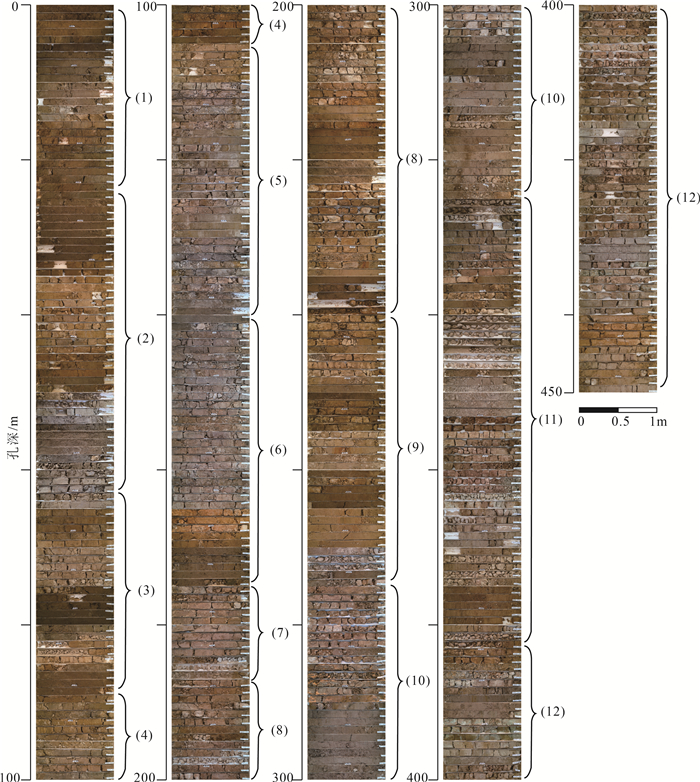
钻孔QYJ01岩性主要包括粘土、粉砂质粘土、粘土质粉砂、粉砂、细砂、粗砂及砂砾,野外编录分成419个自然层位,通过对沉积物岩性、颜色、沉积组合和沉积相分析,将其分为十二大岩性段(图 2)。
(1) 孔深0~23.7 m,主要为2个正粒序的沉积旋回,0~14 m为灰黄色-褐黄色粉砂质粘土-粘土质粉砂-粉砂-细砂-中砂,14~23.7 m为灰黄色-褐黄色粘土-粉砂-细砂-中砂-粗砂。中砂中偶见钙质结核,粒径4~8 mm;粗砂中偶见暗色矿物条带,18.15~19.10 m为深灰色粘土层;粘土层局部见锈染,偶见小型螺类化石。
(2) 孔深23.7~62.85 m,上部为黄灰色-绿灰色细砂-中砂-粗砂的沉积旋回,偶见螺类化石碎片和钙质结核,少见泥砾;下部为多个棕黄色-黄棕色粘土-粉砂质粘土-粉砂-中砂/细砂/砂砾组成的沉积旋回,粘土层见锰染和锈染,中砂层见10~40 mm钙质结核和泥砾,砂砾层的砾石以中砾为主。
(3) 孔深62.85~88.65 m,包含5个灰黄色-棕灰色粘土-粉砂质粘土-粘土质细砂及灰绿色细砂-中砂/砾石组成的沉积旋回。粘土和粘土质粉砂中见锈染,偶见钙质结核;细砂-中砂呈粒序层理,砾石以中砾为主。
(4) 孔深88.65~105.1 m,上部为2个灰黄色-绿灰色粘土质粉砂/粉砂质粘土-灰黄色粉砂组成的沉积旋回,粉砂中偶见2~20 mm的钙质结核,最大粒径50 mm;下部为灰黑色/红棕色粘土-浅灰色粘土质粉砂-灰绿色细砂-灰黄色中砂组成的沉积旋回,粘土中多见锈染、可见大量贝壳碎屑,偶见3~15 mm的钙质结核、最大粒径40 mm,底部中砂分选性好。
(5) 孔深105.1~141.25 m,上部以灰色粘土-黄绿色粉砂质粘土组成的小型沉积旋回为主,粘土中见5~10 mm钙质结核,偶见贝壳化石碎屑;下部为以红棕色粘土/黄绿色-绿灰色粘土质粉砂-黄灰色-灰绿色细砂-中砂组成的沉积旋回,粘土质粉砂中多见锈染,中砂中见贝壳化石碎屑。
(6) 孔深141.25~174.85 m,上部以黄棕色-棕红色粘土-粉砂质粘土为主,多见5~20 mm钙质结核,149.85~149.95 m处和150.5~150.6 m处夹钙质团块、中砾状,少见锈染或锈斑,可见细粒贝壳化石碎片;下部以灰色细砂-中砂-粗砂-砾石为主,偶见钙质结核,分选性中等,底部夹黄褐色粗砂薄层,厚5 mm,与下伏地层呈突变接触。
(7) 孔深174.85~187.15 m,包含2个灰棕色粘土-花棕色粉砂质粘土的小型沉积旋回和1个红棕色粘土-黄棕色粉砂质粘土-灰白色胶结细砂-灰黄色中砂组成的沉积旋回,中砂中可见泥砾,底部(187.00~187.15 m处)夹钙锰质结核堆积薄层,厚0.15 m,粒径一般10~20 mm,最大30 mm,与下伏地层呈突变接触关系。
(8) 孔深187.15~239.7 m,上部包含多个黄棕色-红棕色粘土-粉砂质粘土-粘土质粉砂组成的小型沉积旋回,局部见锈染,粘土质粉砂中偶见5~15 mm钙质结核,可见半固结黄白色粘土斑块;下部包含2个黄棕色粉砂质粘土-粘土质粉砂与灰绿色-灰黄色细砂-中砂组成的沉积旋回,细砂中见20 mm砾石,中砂中见泥砾,底层细砂胶结明显,偶见锈染;底部为砾石层,分选性差。
(9) 孔深239.7~274.6 m,由4个灰棕色-黄棕色粘土-粉砂质粘土-绿灰色-灰黄色细砂-中砂组成的沉积旋回组成,上部粘土、粉砂质粘土较厚,偶见潴育化斑块;下部细砂中砂厚度较大,偶见钙质结核,粒径5~20 mm,偶见铁锰质结核,一般为5~15 mm。
(10) 孔深274.6~324.65 m,上部为红棕色-黄棕色粘土-粉砂质粘土-绿灰色细砂-中砂-粗砂的沉积旋回,粘土层中多见钙质结核,粒径一般5~20 mm,最大40 mm;下部为黄棕色-灰黄色粘土-粉砂质粘土-粘土质粉砂-黄灰色粉砂-中砂-细砂-粗砂或砾砂的沉积旋回,偶见泥砾和火山岩屑,偶见锈染,砾石以次棱角状-圆形中砾为主。
(11) 孔深324.65~382.65 m,由3个灰黄色-紫红色粘土-黄棕色粉砂质粘土-黑灰色-绿灰色粉砂-细砂-中砂-粗砂的沉积旋回组成,粘土层刀切面光滑,见钙质结核,砂层较厚,砂呈胶结砂状、胶结程度中等以上,偶见泥砾、火山碎屑和小型砾石。
(12) 382.65~450.9 m,包含5个红棕色-杂色-棕褐色粘土-粘土质粉砂-灰棕色-灰绿色粉砂-细砂/中砂的沉积旋回,偶见小型钙质结核和轻微锈染,砂呈胶结状,偶见潴育化斑块,底部局部锈染强烈。
3.2 古地磁
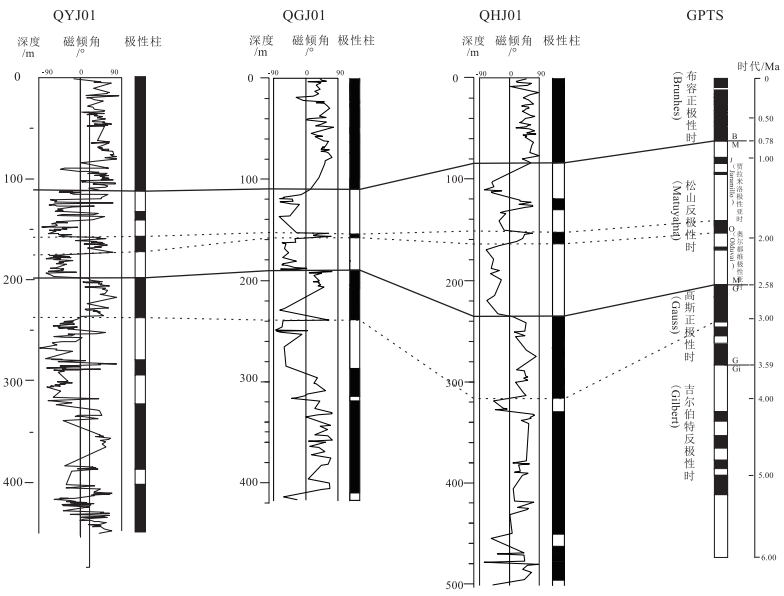
采用PaleoMag古地磁专用数据处理软件对古地磁实验结果数据进行分析,绘制了退磁衰减曲线和正交投影图(图 3),采用主成分分析法并通过原点线性拟合得到特征剩磁方向,剔除最大角偏差(MAD)大于15°的样品,共获得可靠特征剩磁504个。从正交投影图可以看出,在20 mT以上的磁场作用下基本可以分离出特征剩磁。根据QYJ01孔磁倾角的变化特征建立QYJ01孔极性倒转序列(图 4),可以看出QYJ01孔的极性倒转序列较规则,通过与国际标准古地磁极性柱进行对比,钻孔自上而下可分为3个明显的极性时。
布容正极性时(Brunhes):对应孔深0~111.5 m,表现为正极性时,其地质时代为0~0.78 Ma,属全新统和中—上更新统。
松山反极性时(Matuyama):对应孔深111.5~198.1 m,以反极性时为主,夹2个长短不同的正极性时,其地质时代为0.78~2.58 Ma,属早更新世。通过与国际标准古地磁极性柱相比,其中133.5~140.1 m处正极性时厚度较大,与松山反极性时的贾拉米洛正极性亚时(Jaramillo)对应,地层年代相当于0.98~1.07 Ma;157.5~172.2 m处正极性时厚度较大,与松山反极性时的奥尔都维正极性亚时(Olduvai)对应,地层年代相当于1.77~1.95 Ma。
高斯正极性时(Gauss):对应孔深198.1 m以下,表现为正极性时,其代表的是2.58~3.59 Ma的地层。其中孔深198.1~237.8 m对应C2An.1n正极性亚时[31],相当于地层年代2.58~ 3.03 Ma。
4. 讨论
4.1 年代地层划分
以古地磁极性倒转序列和14C测年结果为主要依据,结合岩石地层分层特征,对QYJ01钻孔进行年代地层划分。
全新统(Qh):孔深0~23.7 m。QYJ01钻孔中18.15~ 19.10 m处为北方普遍存在的末次冰期开始出现的泥炭层,有机质含量丰富,向上14.00~ 18.15 m处粘土颜色变为褐黄色-黄灰色,一般认为泥炭层是冰期后气候转暖、降水增多的标志[32]。由表 1可知,在孔深5.8 m处的14C测年样品距今3681a,结合河北平原区及周边全新世沉积物厚度分布及岩性岩相变化特征[18, 33],仿照北京、天津地区的相似钻孔经验[32, 34-36],以末次冰期开始出现的泥炭层所在沉积旋回底界作为全新统底界,将QYJ01钻孔全新统底界确定为23.7 m,与钻孔第1岩性段对应。
上更新统(Qp3):孔深23.7~88.65 m。孔深32.8 m处的14C测年样品距今23323 a,将QYJ01钻孔上更新统底界确定为88.65 m,对应钻孔第3岩性段。
中更新统(Qp2):孔深88.65~111.5 m。根据古地磁极性倒转序列布容正极性时和松山反极性时(B/M)的时间,其对应孔深为111.5 m,作为中更新统底界。
下更新统(Qp1):孔深111.5~ 198.1 m。据古地磁极性倒转序列中的松山反极性时和高斯正极性时(M/G)的时间,将QYJ01孔的下更新统底界(即第四系底界)确定为198.1 m。
上新统(N2):孔深198.1~450.9 m,未见底。其中深度198.1~ 237.8 m对应C2An.1n正极性亚时,属上新统。
4.2 晚新生代沉积速率特征
根据QYJ01钻孔年代地层划分结果,结合研究区北部QGJ01钻孔和研究区中东部QHJ01钻孔年代地层划分的成果(图 4)[25, 33],综合分析永定河冲积平原南部第四纪沉积速率特征(图 5)[37]。
上新世(N2)下部地层在钻孔QYJ01、QGJ01和QHJ01中均未见底,但从已经获得的岩心厚度和早上新世经历的地质时间推算,三者沉积速率均较大,表明在早上新世永定河冲积平原南部经历了一个快速沉降的过程。部分学者[38-39]通过环渤海地区年代地层研究结果得出,大约3.7 Ma以前以河流相和冲洪积相沉积为主,盆地快速沉降,永定河冲积平原南部早上新世的快速沉降过程与此观点有很好的一致性。晚上新世(N22),钻孔QYJ01、QGJ01和QHJ01对应的沉积速率分别为88 m/Ma、124 m/Ma和194 m/Ma,此时永定河冲积平原南部的沉积中心靠近中东部,其次为北部,南部沉积速率最低。
早更新世(Qp1),钻孔QHJ01的沉积速率仍然较大,为85 m/Ma,其所处位置靠近永定河冲积平原南部的沉积中心;QYJ01和QGJ01沉积速率相差不大,分别为48 m/Ma和43 m/Ma,可见在早更新世永定河冲积平原南部的沉积中心向南偏移。
中更新世(Qp2),钻孔QYJ01的沉积速率超过QGJ01和QHJ01,达76 m/Ma, QGJ01和QHJ01对应的沉积速率分别为71 m/Ma和45 m/Ma,此时永定河冲积平原南部的沉积中心靠近南部,其次为北部,东部沉积速率最低。
晚更新世(Qp3),钻孔QYJ01、QGJ01和QHJ01对应的沉积速率分别为325 m/Ma、320 m/Ma和241 m/Ma,维持了中更新世的沉积速率特征。
钻孔QYJ01、QGJ01和QHJ01的全新世(Qh)地层沉积厚度分别为23.7 m、21.45 m和24.9 m,对应的沉积速率分别为2370 m/Ma、2145 m/Ma和2490 m/Ma,可见永定河冲积平原南部全新世地层沉积速率很快,且永定河冲积平原南部不同位置全新世地层沉积速率差别不大,沉积中心靠近研究区中东部。
综上所述,永定河冲积平原南部第四纪沉积中心经历了2次偏移,第1次是始于早更新世、在中更新世完成的沉积中心由中东部向南部偏移,第2次是在全新世完成的沉积中心由南部向中东部回迁。
沉积中心的迁移可能是由于新构造运动以来,燕山与太行山区强烈的构造隆起与构造差异运动造成的。早更新世末期与中更新世初期,燕山与太行山区强烈的构造隆升作用[40-41],造成了永定河冲积平原南部沉积中心的第一次偏移,晚更新世末期与全新世早期新构造运动的构造活动减弱,沉积中心随之回迁至研究区中部。
5. 结论
(1) 通过对钻孔QHJ01古地磁样品的测试分析得出,孔深0~111.5 m为古地磁极性带的布容正极性时,111.5~198.1 m为古地磁极性带的松山反极性时,198.1 m以下为古地磁极性带的高斯正极性时。
(2) 根据古地磁极性倒转序列和14C测年结果,结合岩石地层特征,将钻孔QYJ01年代地层划分为上新统、下更新统、中更新统、上更新统和全新统,其对应孔深分别为198.1~450.9 m、111.5~198.1 m、88.65~111.5 m、23.7~88.65 m和0~23.7 m。
(3) 根据永定河冲积平原南部第四纪代表性钻孔QYJ01、QGJ01和QHJ01的沉积速率特征分析,发现永定河冲积平原南部第四纪沉积中心经历了2次偏移,第1次是始于早更新世、在中更新世完成的沉积中心由中东部向南部偏移,第2次是在全新世完成的沉积中心由南部向中东部回迁。
致谢: 感谢中国地质调查局发展研究中心李仰春研究员、西安地质调查中心李建星研究员等对本文提出的诸多建设性意见。 -
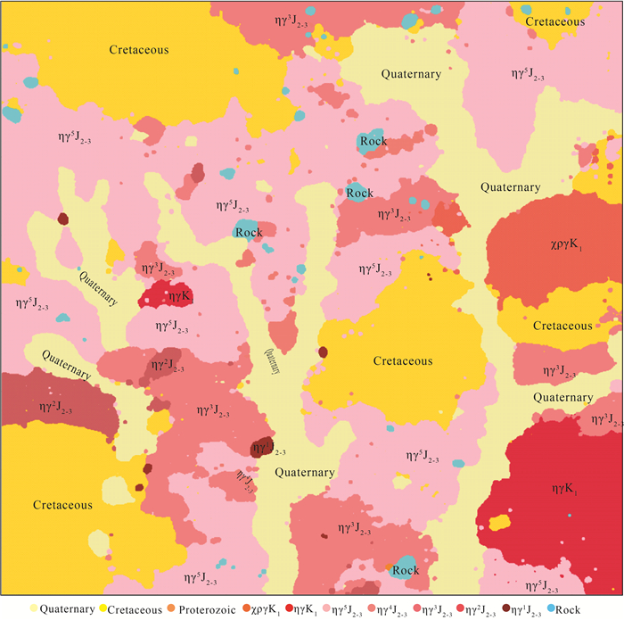
图 4 浅覆盖区望峰公社幅地质简图(据参考文献[46]修改)
Figure 4. Geological map of Wangfeng Commune Sheet in shallow coverage area
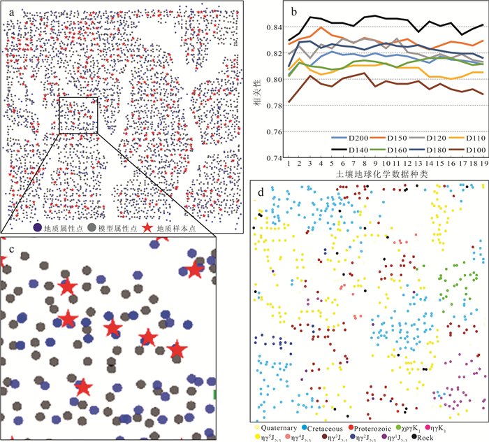
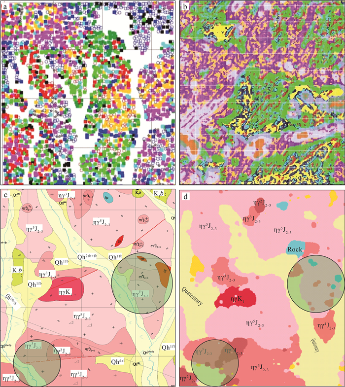
图 16 标签的选择与制定分析结果(岩性代号同图 4)
a—属性点空间分布图;b—搜索参数测试分析结果;c—地质样本点局部分布特征;d—模型标记空间
Figure 16. Analysis results of the label selection and formulation
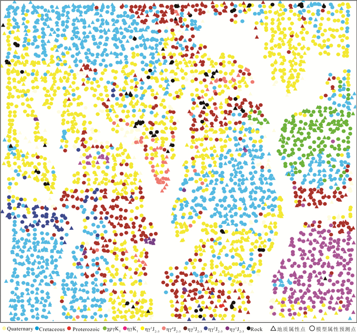
图 17 所有属性点的模型预测结果(岩性代号同图 4)
Figure 17. Model prediction results of all attribute points
图 18 基于大数据深度学习的望峰公社幅地质图(岩性代号同图 4)
Figure 18. Geological map of Wangfeng Commune Sheet based on deep learning of big data
表 1 研究区不同位置覆盖层厚度
Table 1 Thickness statistics of the overburden at different location in the study area
类型 (近)山顶处/m 山坡处/m (近)山脚处/m 腐殖土层 0.05~0.15 0.15~0.2 0.2~0.5 坡积砂、砾、碎石、粘土层 ≥0.3~0.5 ≥0.5~1.25 ≥1.25~2.5 残积碎石层 ≥0.3~0.5 ≥0.3~1.5 ≥1.5~2.5 表 2 望峰公社幅源数据
Table 2 Statistical list of source data of Wangfeng Commune Sheet
类别 序号 数据内容 数据格式 数据量 地质资料 1 地质路线 Excel表格 共计485条 2 地质剖面(含导线库、分层库、小结等信息) Excel表格 共20条 3 各类样品 Excel表格 硅酸盐稀土微量85件,薄片1236件、锆石U-Pb样品17件 遥感数据 4 SPOT6 影像资料 234/RGB 物探资料 5 1:5万航空磁测数据(原始数据) Excel表格 共93739个数据 6 1:2万地面高精度磁测(原始数据) Excel表格 共2124个数据 化探资料 7 1:5万土壤地球化学测量(原始数据) Excel表格 共2565个数据 8 1:2万土壤地球化学测量(原始数据) Excel表格 1913个数据(含重复样) 9 土壤及综合剖面的岩石样品数据 Excel表格 共274个数据 表 3 主要特征地球化学元素统计
Table 3 Statistical analysis result of the main characteristic geochemical elements
元素分类 元素 均值 标准差 最小值 25% 50% 75% 最大值 成规模成矿元素 Ag 0.17 0.18 0.02 0.07 0.11 0.18 3.33 As 6 2 1 4 6 7 44 Au 0.67 0.54 0.3 0.5 0.6 0.7 20.6 Bi 0.51 1.04 0.03 0.29 0.37 0.49 32.6 Mo 2.5 3.9 0.3 1.1 1.6 2.5 64.8 Ni 15 6 2 11 15 18 60 Pb 33 18 14 26 29 34 289 W 2.0 1.3 0.3 1.6 1.9 2.2 25.3 不成规模成矿元素 Cu 15 5 3 12 15 17 65 Hg 0.04 0.01 0.01 0.03 0.04 0.04 0.07 Mn 1215 772 54 658 1045 1571 8167 Sb 0.4 0.1 0.1 0.3 0.4 0.5 1.5 Sn 2.7 0.7 1.0 2.3 2.7 3.1 9.4 Zn 105 51 7 78 96 120 780 微量元素 La 32 13 3 26 29 34 212 Sr 241 104 57 168 223 285 1143 Th 10 3 2 8 9 11 40 U 2.8 1.8 0.5 2.1 2.5 2.9 57.1 Y 17 6 5 14 17 19 94 造岩元素 Al2O3 15 1 11 15 15 16 21 CaO 0.9 0.3 0.3 0.8 0.9 1.1 4.2 TFe2O3 4.6 1.0 0.6 4.0 4.5 5.1 15.1 K2O 1.9 1.0 0.1 1.0 2.3 2.8 4.4 MgO 1.9 1.0 0.1 1.0 1.5 2.9 4.6 Na2O 2.4 0.7 0.3 1.9 2.3 2.8 5.3 SiO2 65 3 50 64 65 67 74 注:25%,50%和75%分别代表 25百分位数、中位数和75百分位数 表 4 主要地球化学元素相关性分析
Table 4 Correlation analysis result of some geochemical elements
元素 As Co Cr Cu La Mn Nb Ni Pb Sb Sr Th Ti U V Zn Al2O3 CaO TFe2O3 K2O MgO Na2O SiO2 As 1.00 0.43 0.50 0.47 0.25 0.17 0.15 0.44 0.21 0.59 -0.31 0.30 0.26 0.17 0.57 0.24 0.30 -0.17 0.63 -0.09 0.06 -0.54 -0.39 Co 1.00 0.63 0.46 0.23 0.54 0.13 0.64 0.12 0.32 -0.03 0.23 0.44 0.07 0.61 0.25 0.24 0.24 0.71 0.02 -0.02 -0.41 -0.57 Cr 1.00 0.55 0.28 0.31 0.33 0.90 0.11 0.51 -0.31 0.32 0.54 0.12 0.71 0.31 0.21 0.06 0.60 -0.02 -0.01 -0.75 -0.50 Cu 1.00 0.46 0.22 0.08 0.52 0.28 0.41 -0.15 0.38 0.40 0.29 0.63 0.33 0.38 0.13 0.65 -0.15 0.11 -0.52 -0.56 La 1.00 0.17 0.06 0.26 0.21 0.15 -0.15 0.63 0.06 0.50 0.27 0.14 0.28 0.13 0.33 -0.04 0.03 -0.29 -0.44 Mn 1.00 0.27 0.36 0.19 0.31 -0.27 0.17 0.18 0.04 0.21 0.42 -0.08 -0.02 0.33 -0.05 0.05 -0.35 -0.22 Nb 1.00 0.27 0.13 0.37 -0.56 0.35 0.40 0.07 0.17 0.31 -0.15 -0.40 0.16 -0.12 0.12 -0.35 0.12 Ni 1.00 0.10 0.41 -0.22 0.33 0.39 0.09 0.59 0.31 0.30 0.16 0.61 0.06 -0.04 -0.62 -0.56 Pb 1.00 0.28 -0.16 0.17 0.04 0.12 0.12 0.60 0.09 -0.12 0.16 -0.07 0.06 -0.17 -0.18 Sb 1.00 -0.46 0.20 0.44 0.09 0.56 0.44 0.14 -0.33 0.53 -0.13 0.10 -0.63 -0.25 Sr 1.00 -0.37 -0.03 -0.14 -0.12 -0.26 0.17 0.60 -0.16 0.14 -0.11 0.64 -0.09 Th 1.00 -0.01 0.52 0.19 0.16 0.31 -0.07 0.32 -0.14 0.17 -0.33 -0.36 Ti 1.00 -0.02 0.78 0.30 0.09 0.08 0.60 0.00 -0.04 -0.38 -0.24 U 1.00 0.12 0.08 0.15 0.07 0.10 -0.08 0.07 -0.18 -0.25 V 1.00 0.29 0.38 0.12 0.89 0.01 -0.06 -0.61 -0.58 Zn 1.00 0.12 -0.11 0.36 -0.06 0.04 -0.33 -0.34 Al2O3 1.00 0.15 0.49 -0.01 0.05 -0.07 -0.66 CaO 1.00 0.12 0.02 0.01 0.30 -0.39 TFe2O3 1.00 -0.01 -0.03 -0.59 -0.73 K2O 1.00 -0.96 0.05 -0.02 Mgo 1.00 0.04 0.03 Na2O 1.00 0.33 SiO2 1.00 表 5 磁异常分布规律参数的统计描述、数学表述和意义
Table 5 Statistical description, mathematical expression and significance of magnetic anomaly distribution parameters
统计描述 数学表述 意义 均值 mean(X(n, m)) 强弱 极大值~极小值 max(X(n, m))~min(X(n, m)) 范围 极大值 max(X(n, m)) 极大值 正值个数/负值个数 number(plus(X(n, m)))/ number(negative(X(n, m))) 跳动幅度 峰度 kurtosis(X(n, m)) 数据陡缓程度 偏度 skewness(X(n, m)) 分布对称性 表 6 航磁数据特征属性的相关性分析结果
Table 6 Correlation analysis result of the aeromagnetic data characteristic attributes
属性 mean median min max var std skew diff bf mean 1.00 1.00 0.98 0.98 0.14 0.22 -0.17 0.22 0.00 median 1.00 0.98 0.98 0.14 0.22 -0.19 0.21 0.00 min 1.00 0.94 0.00 0.06 -0.15 0.05 -0.03 max 1.00 0.27 0.38 -0.14 0.38 0.01 var 1.00 0.82 0.01 0.82 0.09 std 1.00 0.00 0.99 0.12 skew 1.00 0.01 -0.07 diff 1.00 0.13 bf 1.00 表 7 土壤地球化学数据指标分组及其元素组合
Table 7 Model grouping and element combination of the soil geochemical data
指标 元素组合 指标一 K2O、MgO 指标二 Au、Hg、Mo 指标三 Bi、W 指标四 V、Y、U、Fe2O3、Na2O、SiO2 指标五 As、Co、Cr、Cu、La、Nb、Ni、Sb、Sn、Sr、Ti、Th、V、Y、U、Fe2O3、Na2O、SiO2 指标六 所有33种元素 -
自然资源部中国地质调查局. 区域地质调查技术要求(1: 50 000)[S]. 北京, 2019. 王涛, 张进, 黄河, 等. 前言[J]. 地质通报, 2017, 36(11): 文前. http://dzhtb.cgs.cn/gbc/ch/reader/view_abstract.aspx?file_no=20171101&flag=1 胡健民. 特殊地区地质填图工程概况[J]. 地质力学学报, 2016, 22(4): 803-808. doi: 10.3969/j.issn.1006-6616.2016.04.001 严光生, 薛群威, 肖克炎, 等. 地质调查大数据研究的主要问题分析[J]. 地质通报, 2015, 34(7): 1273-1279. doi: 10.3969/j.issn.1671-2552.2015.07.004 王翔, 李景朝, 陈辉, 等. 大数据与地质资料信息服务: 需求、产品、技术、共享[J]. 地质通报, 2015, 34(7): 1309-1315. doi: 10.3969/j.issn.1671-2552.2015.07.008 李超岭, 李健强, 张宏春, 等. 智能地质调查大数据应用体系架构与关键技术[J]. 地质通报, 2015, 34(7): 1288-1299. doi: 10.3969/j.issn.1671-2552.2015.07.006 陈建平, 李婧, 崔宁, 等. 大数据背景下地质云的构建与应用[J]. 地质通报, 2015, 34(7): 1260-1265. doi: 10.3969/j.issn.1671-2552.2015.07.002 黄少芳, 刘晓鸿. 地质大数据应用与地质信息化发展的思考[J]. 中国矿业, 2016, 25(8): 166-170. doi: 10.3969/j.issn.1004-4051.2016.08.035 吴冲龙, 刘刚, 张夏林, 等. 地质科学大数据及其利用的若干问题探讨[J]. 科学通报, 2016, 61(16): 1797-1807. https://www.cnki.com.cn/Article/CJFDTOTAL-KXTB201616011.htm 胡健民, 陈虹, 梁霞, 等. 特殊地区地质填图技术方法及应用成果[J]. 地质力学学报, 2017, 23(2): 181. https://www.cnki.com.cn/Article/CJFDTOTAL-DZLX201702001.htm Giri K J, Lone T A. Big Data - overview and challenges[J]. International Journal of Advanced Research in Computer Science and Software Engineering, 2014, 4(6): 525-529.
Gandomi A, Haider M. Beyond the hype: Big data concepts, methods, and analytics[J]. International Journal of Information Management, 2015, 35: 137-144. doi: 10.1016/j.ijinfomgt.2014.10.007
Sagiroglu S, Sinanc D. Big data: A review[C]//San Diego, CA: 2013.
郑啸, 李景朝, 王翔, 等. 大数据背景下的国家地质信息服务系统建设[J]. 地质通报, 2015, 34(7): 1316-1322. doi: 10.3969/j.issn.1671-2552.2015.07.009 李婧, 陈建平, 王翔. 地质大数据存储技术[J]. 地质通报, 2015, 34(8): 1589-1594. doi: 10.3969/j.issn.1671-2552.2015.08.018 赵亚楠, 李朝奎, 肖克炎, 等. 基于Hadoop的地质矿产大数据分布式存储方法[J]. 地质通报, 2019, 38(2/3): 462-470. http://dzhtb.cgs.cn/gbc/ch/reader/view_abstract.aspx?file_no=2019020327&flag=1 吴冲龙, 刘刚. 大数据与地质学的未来发展[J]. 地质通报, 2019, 38(7): 1081-1088. http://dzhtb.cgs.cn/gbc/ch/reader/view_abstract.aspx?file_no=20190701&flag=1 Cheng Q, Oberhänsli R, Zhao M. A new international initiative for facilitating data-driven Earth science transformation[J]. Geological Society, London, Special Publications, 2020, 499: 10-1144.
陈应军, 严加永. 澳大利亚三维地质填图进展与实例[J]. 地质与勘探, 2014, 50(5): 884-892. https://www.cnki.com.cn/Article/CJFDTOTAL-DZKT201405008.htm 刘凤山, 胡道功. 欧美国家地质填图的理念、管理与战略[J]. 地质通报, 2009, 28(10): 1405-1410. doi: 10.3969/j.issn.1671-2552.2009.10.006 石宏仁. 澳大利亚新一代地质填图工作模式[J]. 中国地质, 1998, 25(1): 34-35. https://www.cnki.com.cn/Article/CJFDTOTAL-DIZI199801011.htm 张凡. 加拿大国家地质填图计划[J]. 国土资源情报, 2012, 137: 34-36. https://www.cnki.com.cn/Article/CJFDTOTAL-GTZQ201205011.htm 李仰春, 王永志, 陈圆圆, 等. 智绘地质———新一代智能化地质编图模式及应用[J]. 地质通报, 2020, 39(6): 861-870. http://dzhtb.cgs.cn/gbc/ch/reader/view_abstract.aspx?file_no=20200606&flag=1 胡道功, 刘凤山, 吴珍汉, 等. 欧美地质填图方法: 经验、试点与建议——以东昆仑造山带填图试验为例[M]. 北京: 地质出版社, 2013: 1-334. 李建星, Chen S, 毛晓长, 等. 中(西)澳地质填图对比及对中国地质填图的启示[J]. 地质通报, 2015, 34(12): 2143-2149. doi: 10.3969/j.issn.1671-2552.2015.12.001 张颖慧, Morelli R, 郭磊, 等. 中加基岩地质填图与三维地质建模合作交流经验与启示[J]. 地质通报, 2018, 37(2/3): 314-324. http://dzhtb.cgs.cn/gbc/ch/reader/view_abstract.aspx?file_no=2018020311&flag=1 胡健民, 陈虹. 覆盖区区域地质填图指导思想与方法体系的创新与探索——特殊地质地貌区填图试点项目成果概述[J]. 地质力学学报, 2019, 25(5): 1001-1002. https://www.cnki.com.cn/Article/CJFDTOTAL-DZLX201905027.htm 吴冲龙, 刘刚. "玻璃地球"建设的现状、问题、趋势与对策[J]. 地质通报, 2015, 34(7): 1280-1287. doi: 10.3969/j.issn.1671-2552.2015.07.005 李丰丹, 李超岭, 吴亮, 等. 大数据环境下数字填图数据集成服务技术[J]. 地质通报, 2015, 34(7): 1300-1308. doi: 10.3969/j.issn.1671-2552.2015.07.007 张野, 李明超, 韩帅. 基于岩石图像深度学习的岩性自动识别与分类方法[J]. 岩石学报, 2018, 34(2): 333-342. https://www.cnki.com.cn/Article/CJFDTOTAL-YSXB201802010.htm 彭伟航, 白林, 商世为, 等. 基于改进InceptionV3模型的常见矿物智能识别[J]. 地质通报, 2019, 38(12): 2059-2066. http://dzhtb.cgs.cn/gbc/ch/reader/view_abstract.aspx?file_no=20191214&flag=1 鱼眼看矿业. 智能地质调查新进展: 探索"地质大脑+人工智能"新模式[Z]. 2018, https://www.tinymind.net.cn/news/cd8a05bd967423. 邓震, 孟贵祥, 汤贺军, 等. 浅覆盖区1: 5万基岩地质填图实践探索——以准噶尔北缘克什克涅绍喀尔(L45E009020)图幅为例[J]. 地球学报, 2019, 40(5): 651-660. https://www.cnki.com.cn/Article/CJFDTOTAL-DQXB201905002.htm 李超岭, 张克信, 于庆文, 等. 数字地质填图PRB粒度理论框架研究[J]. 地质通报, 2008, 27(7): 945-955. doi: 10.3969/j.issn.1671-2552.2008.07.003 李超岭, 于庆文, 杨东来, 等. PRB数字地质填图技术研究[J]. 地球科学, 2003(4): 377-383. doi: 10.3321/j.issn:1000-2383.2003.04.003 张克信, 孙赜, 于庆文, 等. 基于数字填图系统的遥感等数据在构造-地层分区和地层单位识别中的应用——以1: 25万民和县幅、临夏市幅和定西市幅数字地质填图为例[J]. 地质通报, 2008(7): 965-973. doi: 10.3969/j.issn.1671-2552.2008.07.005 周铸. 地质云1.0, 开启地质工作智能化模式[Z]. 2017. http://www.zgkyb.com/yuqing/20171110_45932.htm. 吕霞, 李健强, 龚爱华, 等. 基于云架构的中国地质调查信息网格平台关键技术研究与实现[J]. 地质通报, 2015, 34(7): 1323-1332. doi: 10.3969/j.issn.1671-2552.2015.07.010 中国地调局基础部. 智能地质调查[Z]. 2019. http://www.cgs.gov.cn/ddztt/jqthd/qgqdh/cgzsqd/201911/t20191105_497053.html. 朱江. 国家地质大数据共享平台全面升级"地质云2.0"宣布上线服务[Z]. 2018, http://www.cgs.gov.cn/xwl/ddyw/201810/t20181019_469431.html. Wu X, Zhu X, Wu G, et al. Data mining with big data[J]. IEEE Transactions on Knowledge and Data Engineering, 2014, 26(1): 97-107. doi: 10.1109/TKDE.2013.109
Katal A, Wazid M, Goudar R H. Big data: Issues, challenges, tools and Good practices[C]//Noida, 2013.
刘智慧, 张泉灵. 大数据技术研究综述[J]. 浙江大学学报(工学版), 2014, 48(6): 957-972. https://www.cnki.com.cn/Article/CJFDTOTAL-ZDZC201406001.htm Labrinidis A, Jagadish H V. Challenges and Opportunities with Big Data[J]. Proceedings of the VLDB Endowment, 2012, 12(5): 2032-2033.
Han J, Kamber M. 数据挖掘概念与技术[M]. 北京: 机械工业出版社, 2007: 1-488. 王东明, 田世攀, 张昱, 等. 森林-沼泽浅覆盖区地质填图方法试验——以黑龙江1: 5万望峰公社幅为例[J]. 地质通报, 2021, 40(5): 782-797. http://dzhtb.cgs.cn/gbc/ch/reader/view_abstract.aspx?file_no=20210513&flag=1 Feng Z Q, Liu Y J, Liu B Q, et al. Timing and nature of the Xinlin-Xiguitu Ocean: constraints from ophiolitic gabbros in the northern Great Xing'an Range, eastern Central Asian Orogenic Belt[J]. International Journal of Earth Science, 2016, 105: 491-505. doi: 10.1007/s00531-015-1185-z
吴福元, 孙德有. 东北地区显生宙花岗岩的成因与地壳增生[J]. 岩石学报, 1999, 15(2): 181-189. https://www.cnki.com.cn/Article/CJFDTOTAL-YSXB902.003.htm 郝立波, 陆继龙, 马力. 浅覆盖区土壤化学成分与基岩化学成分的关系及其意义——以大兴安岭北部地区为例[J]. 中国地质, 2005, 32(3): 139-144. doi: 10.3969/j.issn.1006-9372.2005.03.043 郝立波, 陆继龙, 李龙, 等. 区域化探数据在浅覆盖区地质填图中的应用方法研究[J]. 中国地质, 2007, 34(4): 710-715. doi: 10.3969/j.issn.1000-3657.2007.04.022 何鹏, 滕学建, 刘洋, 等. 遥感解译在内蒙古狼山戈壁荒漠地区1: 50 000地质填图中的应用[J]. 地质力学学报, 2016, 22(4): 882-892. doi: 10.3969/j.issn.1006-6616.2016.04.007 辜平阳, 陈锐明, 胡健民, 等. 高山峡谷区1: 50 000填图方法指南[M]. 北京: 科学出版社, 2018: 1-136. 山克强, 潘明, 林宇. 无人机航空遥感地质解译在岩石地层单元识别中的应用——以1: 50 000西南岩溶区填图试点为例[J]. 地质力学学报, 2016, 22(4): 933-942. doi: 10.3969/j.issn.1006-6616.2016.04.011 房立民, 杨振升, 李勤, 等. 变质岩区1: 5万区域地质填图方法指南[M]. 武汉: 中国地质大学出版社, 1991. 高秉璋, 洪大卫, 郑基俭, 等. 花岗岩类区1: 5万区域地质填图方法指南[M]. 武汉: 中国地质大学出版社, 1991. 魏家庸, 卢重明, 徐怀艾, 等. 沉积岩区1: 5万区域地质填图方法指南[M]. 武汉: 中国地质大学出版社, 1991. 陈志. 1: 5万区调地质填图新方法介绍[J]. 西北地质, 1996, (1): 49-55. https://www.cnki.com.cn/Article/CJFDTOTAL-XBDI601.009.htm 王涛, 计文化, 胡健民, 等. 专题地质填图及有关问题讨论[J]. 地质通报, 2016, 35(5): 633-641. doi: 10.3969/j.issn.1671-2552.2016.05.001 王国灿, 陈超, 胡健民, 等. 戈壁荒漠覆盖区1: 50 000填图方法指南[M]. 北京: 科学出版社, 2018: 1-240. 李朝柱, 傅建利, 王书兵, 等. 黄土覆盖区1: 50 000填图方法指南[M]. 北京: 科学出版社, 2020: 1-104. 罗照华, 苏尚国, 刘翠. 结构可控的地质解释——侵入岩专题地质填图构想[J]. 地质通报, 2017, 36(11): 2012-2029. doi: 10.3969/j.issn.1671-2552.2017.11.011 潘峰, 李向民, 校培喜, 等. 海相火山岩区地质填图方法——以北祁连山东段白银矿田古火山机构厘定为例[J]. 地质通报, 2017, 36(11): 2045-2053. doi: 10.3969/j.issn.1671-2552.2017.11.014 闫臻, 王宗起, 付长垒, 等. 混杂岩基本特征与专题地质填图[J]. 地质通报, 2018, 37(2/3): 167-191. http://dzhtb.cgs.cn/gbc/ch/reader/view_abstract.aspx?file_no=2018020301&flag=1 张进, 曲军峰, 张庆龙, 等. 基岩区构造地质填图方法思考、实践、探索[J]. 地质通报, 2018, 37(2/3): 192-221. http://dzhtb.cgs.cn/gbc/ch/reader/view_abstract.aspx?file_no=2018020302&flag=1 毛晓长, 王根厚, 梁晓, 等. 增生杂岩带1: 5万地质填图的实践与探索: 以西藏羌塘中部角木日地区为例[J]. 地学前缘, 2015, 22(3): 382-393. https://www.cnki.com.cn/Article/CJFDTOTAL-DXQY201503036.htm 卢占武, 李文辉, 张新彦, 等. 用于专题地质填图的地球物理技术——短周期密集台阵[J]. 地质通报, 2021, 40(1): 1-12. http://dzhtb.cgs.cn/gbc/ch/reader/view_abstract.aspx?file_no=20210101&flag=1 赵汀, 王安建, 刘超. 基于国情调查大数据的矿产资源保障程度动态分析系统设计与实现[J]. 地质通报, 2020, 39(2/3): 400-405. http://dzhtb.cgs.cn/gbc/ch/reader/view_abstract.aspx?file_no=2020020320&flag=1 -
期刊类型引用(4)
1. 刘鹏飞,刘少玉,周晓妮,王哲,张光辉,崔尚进. 华北平原典型区不同砂层井灌中水位水量变化差异特征——以滹沱河冲洪积扇藁城段为例. 科学技术与工程. 2023(02): 502-508 .  百度学术
百度学术
2. 王小江,李培,张凯,荣立新,姜春香,李金丽. 永定河流域新生代地层岩相地震识别. 地质通报. 2023(Z1): 332-342 .  本站查看
本站查看
3. 张梦南,程旭学,李志红,刘伟坡,崔虎群,魏世博,刘伟朋,刘江涛,李永利,陈卓. 三江平原建三江地下水位下降区地面形变监测、评估与预测. 地质通报. 2023(07): 1211-1217 .  本站查看
本站查看
4. 肖都,张强,杜炳锐,袁桂琴,刘建勋,裴发根,李建华,贲放,欧洋,王刚,冯斌,朱威,孙跃. “十一五”以来勘查地球物理发展回顾与展望. 物探化探计算技术. 2022(06): 698-707 .  百度学术
百度学术
其他类型引用(0)


 下载:
下载:
