
Monitoring, evaluation and prediction of ground deformation in the groundwater level drop area of Jiansanjiang area, Sanjiang plain
-
摘要:
三江平原地下水开采量随着水稻种植规模快速扩张而大幅增加, 2021年水位相对1980年下降5~12 m, 是否因此引发地面形变甚至地面沉降成为社会关注的问题。采用二等水准测量方法和比拟法, 分析研究了三江平原建三江垦区地下水位降落漏斗地面形变现状与发展趋势及危险性。研究表明, 研究区50个二等水准测量点2019-2021年连续3期测量数据对比发现, 地表垂向形变量整体较小(最大-18.00 mm, 平均变化速率-4.6 mm/a)。预测到2040年, 地下水位降落漏斗中心水位埋深由2021年的19.88 m降至25 m左右, 考虑到研究区"上粘下砂"的二元岩性结构, 地下水位下降疏干的地层位于浅上部且厚度有限, 地面沉降量仍较小, 地质灾害发育程度弱、危险性小。本研究不仅回应了社会关切, 也为进一步开展相关研究奠定了基础。
Abstract:The amount of groundwater exploitation in the Sanjiang Plain has increased significantly with the rapid expansion of rice planting scale; in addition, the water level in 2021 was 5~12 m lower than that in 1980.Whether it causes ground deformation and land subsidence has become a social concern.In this study, the present situation, development trend and risk of ground deformation of groundwater depression cone in Jiansanjiang reclamation area of Sanjiang plain has been analyzed and studied by using second-order leveling method and analogy method.The results showed that the vertical deformation of the surface was generally small(maximum-18.00 mm, average change rate-4.6 mm/a)by the comparison of the continuous three-period measurement data of 50 second-class leveling points in the study area from the year 2019 to 2021.It has been predicted that the depth of the water level in the center of the groundwater level depression funnel can be reduced from 19.88 m in 2021 to about 25 m in 2040.With the dual lithologic structure of ' upper clay and lower sand ' in the study area, the strata drained by the groundwater level drop was located in the shallow upper part and the thickness was limited.The amount of land subsidence was still small; the degree of geological disaster development was weak and the risk was small.This study was not only reponse to social concerns, but also a foundation for further researches.
-
致谢: 感谢中国地质调查局水文地质环境地质调查中心王晓燕和王赛博士在论文写作过程中提供的宝贵建议和帮助。
-
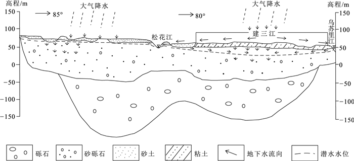
![]()
图 1 三江平原第四系含水层结构空间分布图
Figure 1. Spatial distribution of Quaternary aquifer structure in Sanjiang Plain
![]()
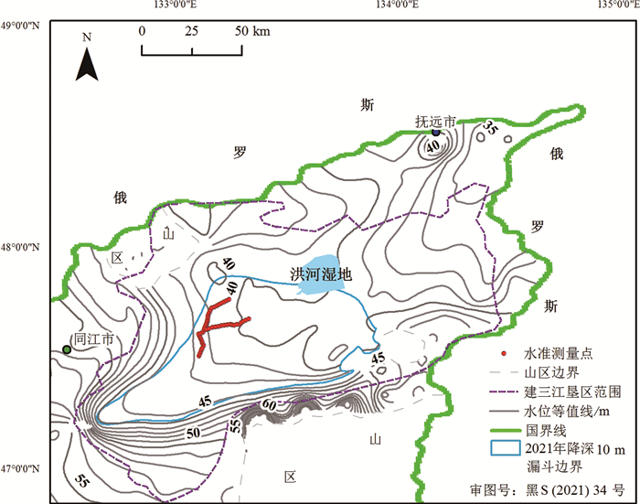
图 2 沉降监测点与地下水等水位线空间关系(2021年3—4月)
Figure 2. Spatial relationship between settlement monitoring point and groundwater level
![]()
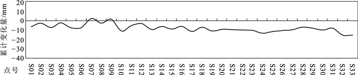
图 3 北东方向纵剖面地面形变累计变化量曲线
Figure 3. Curve of cumulative variation of ground deformation in the northeast longitudinal section
![]()
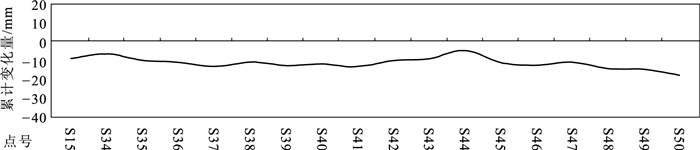
图 4 东西方向横剖面地面形变累计变化量曲线
Figure 4. Curve of cumulative variation of ground deformation in east-west cross section
![]()
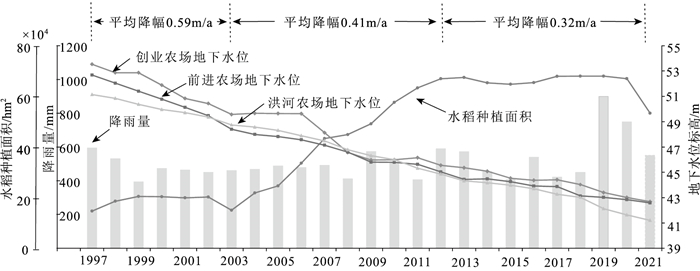
图 5 建三江地区水稻播种面积、降雨量与3月地下水水位关系曲线
Figure 5. Relationship curve between rice planting area, rainfall and groundwater level in March in Jiansanjiang Reclamation area
表 1 2019—2021年50个观测点地面形变
Table 1 List of ground deformation at 50 observation points from 2019 to 2021
点号 变化量/mm 点号 变化量/mm 点号 变化量/mm 二期 三期 累计 二期 三期 累计 二期 三期 累计 S01 -1.0 -5.4 -6.4 S18 -5.1 -2.0 -7.1 S35 -4.8 -5.2 -10.0 S02 -2.6 -0.2 -2.8 S19 -5.3 -5.8 -11.1 S36 -5.9 -5.1 -11.0 S03 -2.0 -5.1 -7.1 S20 -6.7 -2.6 -9.3 S37 -7.5 -5.6 -13.1 S04 -1.5 -1.1 -2.6 S21 -6.8 -3.1 -9.9 S38 -6.4 -4.6 -11.0 S05 -2.9 -4.9 -7.8 S22 -7.1 -3.0 -10.1 S39 -10.1 -2.7 -12.8 S06 -3.0 -4.4 -7.4 S23 -7.8 -2.5 -10.3 S40 -10.4 -1.6 -12.0 S07 -3.1 +5.3 +2.2 S24 -9.0 -4.2 -13.2 S41 -9.2 -4.1 -13.3 S08 -3.3 +0.6 -2.7 S25 -8.1 -3.7 -11.8 S42 -5.9 -4.2 -10.1 S09 -3.3 +4.5 +1.2 S26 -5.0 -5.5 -10.5 S43 -5.8 -3.3 -9.1 S10 -1.2 -9.6 -10.8 S27 -7.8 -1.9 -9.7 S44 -0.6 -4.1 -4.7 S11 -7.5 +2.2 -5.3 S28 -6.6 -0.4 -7.0 S45 -7.2 -4.0 -11.2 S12 -6.3 +3.0 -3.3 S29 -6.7 -1.5 -8.2 S46 -7.1 -5.4 -12.5 S13 -10.6 +1.4 -9.2 S30 -7.8 -2.3 -10.1 S47 -7.4 -3.6 -11.0 S14 -8.7 +2.4 -6.3 S31 -5.7 -2.4 -8.1 S48 -7.6 -6.7 -14.3 S15 -6.5 -2.4 -8.9 S32 -9.0 -6.5 -15.5 S49 -7.9 -7.0 -14.9 S16 -6.7 +0.5 -6.2 S33 -6.7 -8.6 -15.3 S50 -6.3 -11.7 -18.0 S17 -6.5 -5.0 -11.5 S34 -10.5 +3.9 -6.6 平均 -6.2 -3.0 -9.2 注:“+”表示上升,“-”表示下沉  下载: 导出CSV
表 2 地面沉降发育程度分级
Table 2 Grading table of development degree of land subsidence
因素 发育程度 强 中等 弱 近五年平均沉降速率/(mm·a-1) ≥30 10~30 ≤10 累积沉降量/mm ≥800 300~800 ≤300 注:上述2项因素满足一项即可,并按由强至弱顺序确定
下载: 导出CSV
表 3 天津市地面沉降危险性分级
Table 3 Risk classification of land subsidence in Tianjin
地面沉降速率/mm·a-1 危险性分级 0~30 小 30~50 中等 >50 大
下载: 导出CSV
-
代鹏, 邓晓红, 王盛栋, 等. 永定河冲积平原南部第四纪年代地层划分及沉积速率特征[J]. 地质通报, 2022, 41(2/3): 253-261. http://dzhtb.cgs.cn/gbc/ch/reader/view_abstract.aspx?file_no=2022020305&flag=1 狄胜同, 贾超, 张少鹏, 等. 华北平原鲁北地区地下水超采导致地面沉降区域特征及演化趋势预测[J]. 地质学报, 2020, 94(5): 1638-1652. https://www.cnki.com.cn/Article/CJFDTOTAL-DZXE202005020.htm 地质灾害危险性评后规范(GB/T 40112—2021)[S]. 国家市场监督管理局, 中国国家标准化管理委员会, 2021. 郭海朋, 白晋斌, 张有全, 等. 华北平原典型地段地面沉降演化特征与机理研究[J]. 中国地质, 2017, 44(6): 1115-1127. https://www.cnki.com.cn/Article/CJFDTOTAL-DIZI201706008.htm 郭海朋, 李文鹏, 王丽亚, 等. 华北平原地下水位驱动下的地面沉降现状与研究展望[J]. 水文地质工程地质, 2021, 48(3): 162-171. https://www.cnki.com.cn/Article/CJFDTOTAL-SWDG202103021.htm 国家一、二等水准测量规范(GB/T 12897—2006)[S]. 中华人民共和国国家质量监督检验检疫总局, 中国国家标准化管理委员会, 2006. 黑龙江省九○四水文地质工程地质勘察院. 黑龙江省地下水监测站点土建工程Ⅱ标段(2017)监测井[R]. 2017. 李慧. 京津冀平原地下水与地面沉降野外科学观测研究站建设概述[J]. 水文地质工程地质, 2020, 47(5): 191-192. https://www.cnki.com.cn/Article/CJFDTOTAL-SWDG202003024.htm 李文鹏, 王龙凤, 郭海朋, 等. 中国地面沉降防治成效与对策建议[J]. 中国水利, 2021, (7): 32-35. https://www.cnki.com.cn/Article/CJFDTOTAL-SLZG202107012.htm 刘贺, 崔文君, 罗勇, 等. 基于分层监测的北京天竺地面沉降、地下水位与孔隙水压力变化规律[J]. 地质通报, 2022, 41(2): 692-701. http://dzhtb.cgs.cn/gbc/ch/reader/view_abstract.aspx?file_no=20220413&flag=1 刘伟朋, 崔虎群, 刘伟坡, 等. 三江平原地下水流场演化趋势及影响因素[J]. 水文地质工程地质, 2021, 48(1): 10-17. https://www.cnki.com.cn/Article/CJFDTOTAL-SWDG202101002.htm 秦同春, 程国明, 王海刚. 国际地面沉降研究进展的启示[J]. 地质通报, 2018, 37(2/3): 503-509. http://dzhtb.cgs.cn/gbc/ch/reader/view_abstract.aspx?file_no=2018020328&flag=1 盛登宝, 吕义清. 基于数值模拟的地下水开采引起的地面沉降机理和对策研究-以定襄县贾家庄为例[J]. 中国农村水利水电, 2017, (10): 62-64, 69. https://www.cnki.com.cn/Article/CJFDTOTAL-ZNSD201710013.htm 田芳, 罗勇, 周毅, 等. 北京地面沉降与地下水开采时空演变对比[J]. 南水北调与水利科技, 2017, 15(2): 163-169. https://www.cnki.com.cn/Article/CJFDTOTAL-NSBD201702025.htm 王国良, 李桂玲. 地面沉降危险性分级量化分析[J]. 城市地质, 2007, 2(2): 19-28. https://www.cnki.com.cn/Article/CJFDTOTAL-CSDZ200702006.htm 邢一飞. 沧州地面沉降影响因素分析及预测评价研究[D]. 中国矿业大学(北京)博士学位论文, 2017. 杨丽萍, 周志华. 地面沉降与地下水开采相关关系及沉降预测[J]. 南水北调与水利科技, 2016, 14(3): 132-137. https://www.cnki.com.cn/Article/CJFDTOTAL-NSBD201603023.htm 赵子龙. 三江平原水资源开发利用致地面沉降分析及对策[D]. 黑龙江科技大学硕士学位论文, 2015. 中国地质调查局水文地质环境地质调查中心. 三江平原水文地质调查项目2021年度进展报告[R]. 保定, 2021.
计量
- 文章访问数: 1663
- HTML全文浏览量: 275
- PDF下载量: 547
