
A study of tectonic style of the polymetallic ore concentration area in Southern Lhasa terrane——Evidence from deep seismic reflection profile
-
摘要:
位于冈底斯成矿带中段的雄村、娘热地区,因近年来不断发现铁、铜等金属矿床,而逐渐被关注。但是由于缺少地球物理资料,该地区地壳精细结构未能取得清楚的认识。针对横过雄村-娘热矿集区130km深地震反射剖面及25km矿集区内部加密反射剖面的数据,进行了层析静校正、能量补偿、去噪、速度分析等数据处理,获得了雄村-娘热矿集区地壳结构的反射图像。结合本区地质资料,对矿集区深部结构进行了解释和推断,揭示了上地壳多条断裂及各类地质现象,认定断裂与岩浆流动上升方向有关,研究结果对矿集区成矿背景的研究具有一定价值。
Abstract:The Niangre and Xiongcun areas in the middle section of the Gangdise metallogenic belt have gradually attracted attention due to the continuous discovery of metal deposits such as iron and copper deposits in recent years. However, due to the lack of sufficient geophysical data, the fine structure of the crust in this area has not been clearly understood, which restricts the study of the ore-forming background of this area. Employing the data of 130km deep seismic reflection profile of the Xiongcun-Niangre ore concentration area and encrypted reflection profile inside 25km of the ore concentration area, the authors carried out data processing of tomographic static correction, denoising, energy compensation and velocity analysis, and obtained the reflection image crustal structure of the Xiongcun-Niangre ore concentration area. Based on the geological data of this area, the authors explained and inferred the deep structure of the ore concentration area, revealed multiple faults in the upper crust and various geological phenomena. It is determined that the fault is related to the direction of the magma flow. The results have certain value for the study of the oreforming background of the ore concentration area.
-
致谢: 感谢中石化中南分公司第五物探大队对本次工作的数据采集。
-
![]()
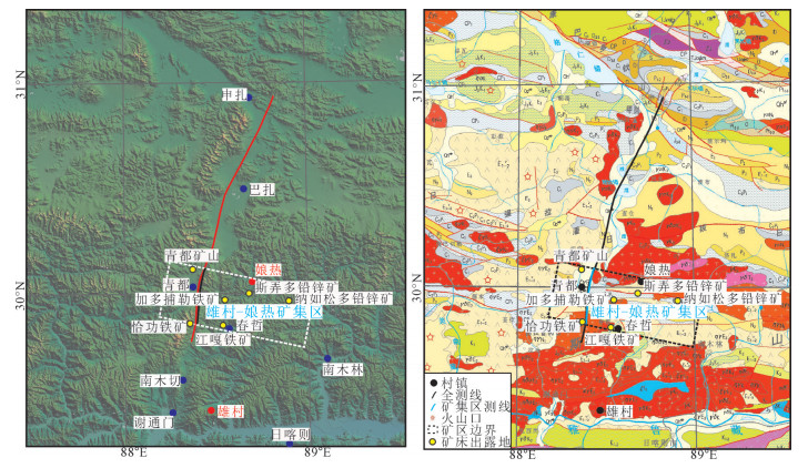
图 1 深地震反射剖面位置示意图[16]
Figure 1. Regional location of the deep seismic reflection profile
![]()
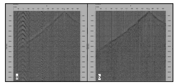
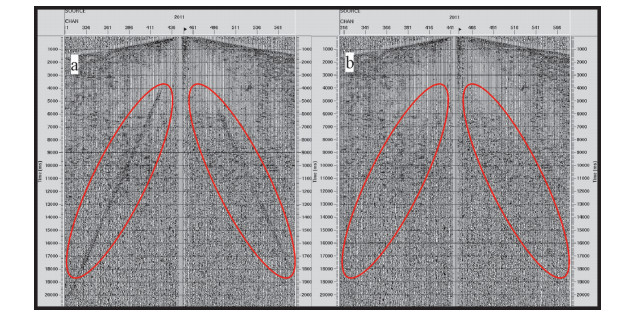
图 3 层析静校正前后对比
a—静校正前;b—静校正后
Figure 3. Comparison of data before and after tomographic static correction
![]()
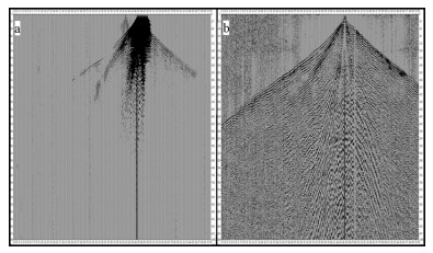
图 4 能量补偿前后对比
a—补偿前;b—补偿后
Figure 4. Comparison of data before and after energy compensation
![]()
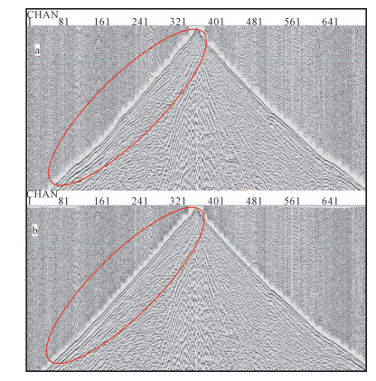
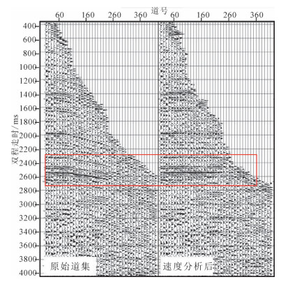
图 5 声波噪声去除前后对比
a—去除前;b—去除后
Figure 5. Comparison of data before and after acoustic noise removal
![]()
图 6 低频噪声去除前后对比
a—去除前;b—去除后
Figure 6. Comparison of data before and after Low frequency noise removal
![]()
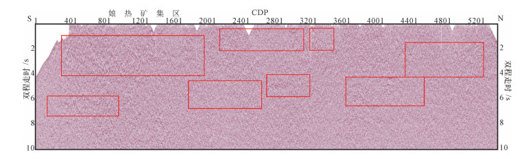
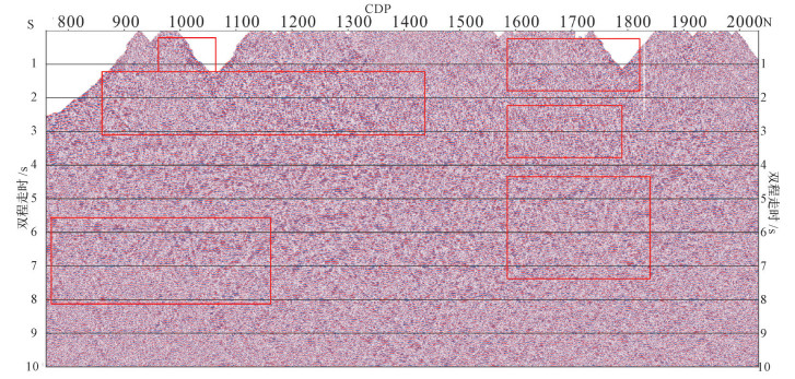
图 10 雄村-娘热矿集区深地震反射叠加剖面
Figure 10. Deep seismic reflection stack profile of Niangre ore concentration area
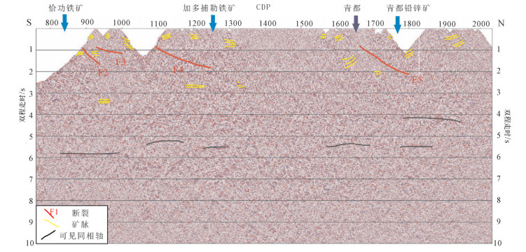
![]()
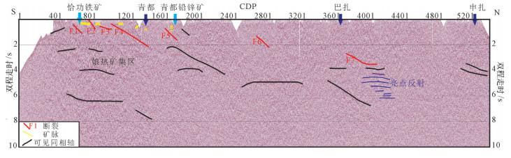
图 11 雄村-娘热矿集区深地震反射解译剖面
Figure 11. Deep seismic reflection interpretation profile of Niangre ore concentration area
表 1 深地震反射剖面(130km)采集参数
Table 1 Deep seismic reflection profile(130km)acquisition parameters
类型 道数 放炮方式 排列参数 叠次/次 道距/m 炮距/m 偏移距/m 药量/kg 小炮 720 中间放炮 17975-25-50-25-17975 ≥60 50 250 25 50 中炮 900 17975-25-50-25-17975 1000 192 22475-25-50-25-22475  下载: 导出CSV
表 2 雄村-娘热矿集区加密段(25km)采集参数
Table 2 Dense section(25km) acquisition parameters of Xiongcun-Niangre ore concentration area
类型 方式 排列参数 叠次/次 道距/m 炮距/m 偏移距/m 药量/kg 浅层单炮 中间放炮 17975-12.5-25(50)-12.5-17975 ≥60 25 100 12.5 16 小炮 17975-12.5-50(25)-12.5-17975 50 250 50 中炮 17975-12.5-50(25)-12.5-17975 (25) 1000 192 22475-12.5-50(25)-12.5-22475
下载: 导出CSV
-
Fowler C M R. The solid earth:an introduction to global geophysics[M]. Cambridge University Press, 1990.
Hubbert M K. Introduction to Geophysical Prospecting[M]. McGraw-Hill, 1960.
Brown L D. A New Map of Crustal 'Terranes' in the United States from COCORP Deep Seismic Reflection Profiling[J]. Geophysical Journal International, 1991, 105(1):3-13. doi: 10.1111/j.1365-246X.1991.tb03439.x
Cook F A. Geometry of the Kapuskasing Structure from a Lithoprobe Pilot Reflection Survey[J]. Geology, 1985, 13(5):368-371. doi: 10.1130/0091-7613(1985)13<368:GOTKSF>2.0.CO;2
Nelson K D, Zhang J. A COCORP Deep Reflection Profile Across the Buried Reelfoot Rift, South-Central United States[J]. Tectonophysics, 1991, 197(24):271-293. http://cn.bing.com/academic/profile?id=10c3b1b6a97f26e02d026d40fcfe31be&encoded=0&v=paper_preview&mkt=zh-cn
高锐, 王海燕, 马永生, 等.松潘地块若尔盖盆地与西秦岭造山带岩石圈尺度的构造关系——深地震反射剖面探测成果[J].地球学报, 2006, 27(5):411-418. doi: 10.3321/j.issn:1006-3021.2006.05.004 Pretorius C C, Trewick W F, Fourie A, et al. Application of 3-D Seismic to Mine Planning at Vaal Reefs Gold Mine, Number 10 Shaft, Republic of South Africa[J]. Geophysics, 2000, 65(6):1862-1870. doi: 10.1190/1.1444870
卢占武, 高锐, 李洪强, 等.深反射地震数据揭示的拉萨地体北部到羌塘地体南部地壳厚度的变化[J].中国地质, 2016, 43(5):1679-1687. http://d.old.wanfangdata.com.cn/Periodical/zgdizhi201605016 高锐, 卢占武, 刘金凯, 等.庐-枞金属矿集区深地震反射剖面解释结果——揭露地壳精细结构, 追踪成矿深部过程[J].岩石学报, 2010, 26(9):2543-2552. http://www.wanfangdata.com.cn/details/detail.do?_type=perio&id=ysxb98201009003 王海燕, 高锐, 卢占武, 等.深地震反射剖面揭露大陆岩石圈精细结构[J].地质学报, 2010, 84(6):818-839. doi: 10.3969/j.issn.1004-9665.2010.06.002 吴功建, 高锐, 余钦范, 等.青藏高原"亚东-格尔木地学断面"综合地球物理调查与研究[J].地球物理学报, 1991, 34(5):552-562. doi: 10.3321/j.issn:0001-5733.1991.05.003 李秋生, 彭苏萍, 高锐.青藏高原莫霍面的研究进展[J].地质论评, 2004, 50(6):598-612. doi: 10.3321/j.issn:0371-5736.2004.06.011 李廷栋.青藏高原地质科学研究的新进展[J].地质通报, 2002, 21(7):370-376. doi: 10.3969/j.issn.1671-2552.2002.07.002 Chang C F, Zeng S L. Tectonic Features of the Mount Jolmo Lungma Region in Southern Tibet, China[J]. Chinese Journal of Geology, 1973, 1:1-12. http://cn.bing.com/academic/profile?id=d2282f34b61b96386f5b3fa3665683da&encoded=0&v=paper_preview&mkt=zh-cn
尹安.喜马拉雅-青藏高原造山带地质演化:显生宙亚洲大陆生长[J].地球学报, 2001, 22(3):193-230. doi: 10.3321/j.issn:1006-3021.2001.03.001 潘桂棠等.青藏高原及邻区地质图[M].成都:成都地图出版社, 2004. 贾海青, 姜弢, 徐学纯, 等.辽西深反射地震勘探采集试验[J].吉林大学学报(地球科学版), 2014, 44(4):1357-1368. http://d.old.wanfangdata.com.cn/Periodical/cckjdxxb201404031 熊翥.复杂地区地震数据处理思路[M].北京:石油工业出版社, 2002. 卢占武, 高锐, 王海燕, 等.深地震反射剖面上的"亮点"构造[J].地球物理学进展, 2014, (6):2518-2525. http://www.cnki.com.cn/Article/CJFDTotal-DQWJ201406006.htm 中国地质科学院地质研究所. 1:100万《中国地质图》[M].北京:地质出版社, 2016.
计量
- 文章访问数: 3357
- HTML全文浏览量: 309
- PDF下载量: 1940
