Geofluid and geological mapping for geofluid
-
摘要:
地质流体是地质作用过程不可缺少的介质,以不同产状和表现形式广泛发育在造山带和沉积盆地的不同演化阶段,是油气和成矿物质形成、运移和定位成矿(藏)的直接载体。流体地质填图作为一种专题地质填图,是在基础地质研究程度较高的地区,为解决与流体形成、运移、聚集过程有关的地质和成矿(藏)问题而进行的地质调查和填图工作。通过对流体地质特征和表现形式的论述,认为流体填图单位应以流体活动类型(同源)和期次(同期)为划分依据,以流体野外宏观地质要素和流体地球化学要素为主要调查内容,填图范围和比例尺灵活多样,成果图应为以反映流体宏观分布特征、流体地球化学性质变化、流体动力学、流体成矿(藏)作用及其分布规律等为内容的一系列图件。流体地质填图为地质科学研究和找矿提供了创新性的地质工作方法和思路。
Abstract:Geofluid played an indispensable role in almost all geological processes and was widely developed in different evolutionary stages of orogeny and sedimentary basin with different occurrences and various forms. Geofluid is considered to be the direct carrier of oil/gas or metal to form reservoir or deposit by migration and accumulation. The aim of geological mapping for geofluid is to solve special geological problems related to geofluid or to investigate natural resources formed along with geofluid formation, migration and accumulation. This paper discusses basic issues of geological mapping for geofluid for detecting features and forms of geofluid both in field outcrop and under microscope. It is proposed that the unit of geological mapping for geofluid should be divided by source and episode of geofluid itself. The essential work of geological mapping for geofluid is mainly to investigate geological features in field outcrop and determine geochemistry of the geofluid. The scale and scope of geologic mapping for geofluid could be flexible and be dependent on the aim and task of the work. Map representation should be a series of maps to reflect field distribution characteristics, variation of geochemistry, geodynamic history, active pathway and mineralization of geofluid. Geological mapping for geofluid provides new methods and ideas for geological research and prospecting work.
-
深覆盖区第四纪地层划分及其沉积速率,是近年的研究热点[1-3]。20世纪,由于国际上对第四系的下限年龄存在分歧,中国华北地区曾出现不同地区采用不同第四系下限的见解。其中,下辽河平原、山东以1.80 Ma为第四纪下限,河北平原以3.06 Ma为下限,北京、河南、天津以2.58 Ma为下限[4]。随着《中国地层指南》[5]的施行,学者们对河北平原及周边第四纪地层划分进行了重新整理和再研究,采用化石群时代[6-8]、气候旋回[9-11]、地层成因划分[12-13]、古地磁极性倒转序列[14-19]及14C、光释光、热释光等测年方法[20-22],并结合测井、电法、浅层地震等地球物理方法[23-25]辅助划分第四纪地层。
目前对于永定河冲积平原南部深覆盖区第四纪地层沉积速率的研究还比较薄弱。本次以永定河冲积平原南部典型第四纪QYJ01钻孔为重点剖析对象,综合岩心分析与古地磁年代地层划分结果,结合研究区北部和东部钻孔G01(即QGJ01)和QHJ01成果,分析第四纪沉积速率特征,并对其意义进行讨论,旨在为深覆盖区地层划分对比研究提供一定的参考。
1. 地质概况
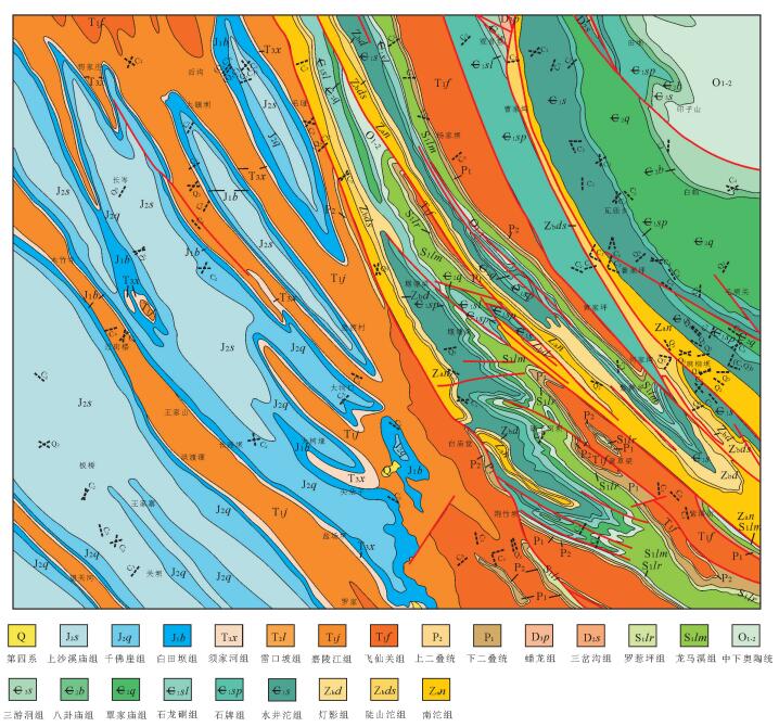
永定河冲积平原南部地处河北平原区北部,其主要构造单元包括廊固凹陷、牛北斜坡、牛驼镇凸起及大兴凸起部分,其中以廊固凹陷为主体。廊固凹陷是渤海湾盆地冀中坳陷的次级构造单元,其北部与大厂凹陷相接,西部与大兴凸起相靠,南部与牛驼镇凸起与霸县凹陷相接,东部与武清凹陷相邻(图 1)。廊固凹陷整体呈北东向展布,南北长约90 km,东西宽20~40 km,总体表现为北断南超的箕状断陷,具有东高西低、南高北低的构造格局[26]。断块变形是廊固凹陷构造变形的基本方式,凹陷内部断裂数量较多,产状较复杂,但控制研究区区域构造发育的主要是西部的大兴断裂及南部的牛东-河西务断裂[27]。研究区第四系厚度较大,成因类型复杂,学者们[4, 9, 11, 16-19]通过多种方法将第四纪地层划分为更新统和全新统,一般将更新统分为3组,全新统分为3组或不做详细区分。区内主要河流为北京的母亲河——永定河,其上游来自官厅水库,主河道流经北京大兴、河北固安、天津北辰等地入渤海,另有北线支流凉水河在天津回归永定河,南线支流白沟河汇入拒马河(图 1)。
QYJ01钻孔位于研究区南侧固安县大吴村村北(图 1),钻孔位置北纬39°19′02.62″、东经116°17′59.44″,实际孔深450.3 m。
2. 研究方法
2.1 样品采集
在钻孔35 m以浅的有机质粘土、泥炭、古土壤中采取了2件14C测年样品,单件样品采样约200 g,用塑料袋封装和送样。14C测年实验在北京大学考古文博学院第四纪年代测定实验室完成,实验结果见表 1。
表 1 QYJ01钻孔14C测年结果Table 1. 14C dating of borehole QYJ01样品编号 实验室编号 岩性 深度/m 14C年代/a B.P. 树轮校正后年龄/cal.a B.P. 1σ 2σ 01 BA172277 粉砂质粘土 5.8 3480±35 3789 3681 02 BA172280 粘土质粉砂 32.8 30680±150 23555 23323 2.2 古地磁测年
古地磁样品的野外现场采集是建立高质量古地磁极性柱的重要前提[28-29]。在采样之前先对研究区及周边区域地质资料进行分析,对钻孔所在位置第四纪地层厚度进行初步确定,然后根据钻孔钻取岩心的实际岩性变化确定采样密度,采样密度一般为2件/m,对粘土、粘土质粉砂、粉砂质粘土、粉砂、细砂以0.5 m间隔取样,中砂、粗砂以1 m间隔取样,对于较难获取古地磁标准样品的砾石层不予取样。取出岩心后,按照一致的顶底方向摆放岩心,并对方向进行标定,刮去表面泥浆,立即进行古地磁采样,规格为2 cm×2 cm×2 cm,采样时对顶底方向严格把关,不可弄反。QYJ01孔古地磁样品取样深度450.3 m,共采集752块样品。
所有的古地磁实验操作在中国科学院地质与地球物理研究所古地磁与年代学实验室的磁屏蔽室(小于300 nT)完成,实验在无磁环境中进行,最大限度地保障了古地磁实验结果的精确性和可靠性。实验的剩磁和退磁过程在集成于一体的2G-760U channel岩石超导磁力仪中进行,剩磁量的测量误差控制在2×10⁻⁸ Am2以内。对所有样品经过逐步退磁处理,以了解岩石中剩磁的稳定性[30]。采用交变退磁场对样品进行退磁,退磁间隔依次为5 mT、10 mT、15 mT、20 mT、25 mT、30 mT、35 mT、40 mT、45 mT、50 mT、55 mT、60 mT、70 mT。
3. 岩心特征和测年结果
3.1 岩心特征
钻孔QYJ01岩性主要包括粘土、粉砂质粘土、粘土质粉砂、粉砂、细砂、粗砂及砂砾,野外编录分成419个自然层位,通过对沉积物岩性、颜色、沉积组合和沉积相分析,将其分为十二大岩性段(图 2)。
(1) 孔深0~23.7 m,主要为2个正粒序的沉积旋回,0~14 m为灰黄色-褐黄色粉砂质粘土-粘土质粉砂-粉砂-细砂-中砂,14~23.7 m为灰黄色-褐黄色粘土-粉砂-细砂-中砂-粗砂。中砂中偶见钙质结核,粒径4~8 mm;粗砂中偶见暗色矿物条带,18.15~19.10 m为深灰色粘土层;粘土层局部见锈染,偶见小型螺类化石。
(2) 孔深23.7~62.85 m,上部为黄灰色-绿灰色细砂-中砂-粗砂的沉积旋回,偶见螺类化石碎片和钙质结核,少见泥砾;下部为多个棕黄色-黄棕色粘土-粉砂质粘土-粉砂-中砂/细砂/砂砾组成的沉积旋回,粘土层见锰染和锈染,中砂层见10~40 mm钙质结核和泥砾,砂砾层的砾石以中砾为主。
(3) 孔深62.85~88.65 m,包含5个灰黄色-棕灰色粘土-粉砂质粘土-粘土质细砂及灰绿色细砂-中砂/砾石组成的沉积旋回。粘土和粘土质粉砂中见锈染,偶见钙质结核;细砂-中砂呈粒序层理,砾石以中砾为主。
(4) 孔深88.65~105.1 m,上部为2个灰黄色-绿灰色粘土质粉砂/粉砂质粘土-灰黄色粉砂组成的沉积旋回,粉砂中偶见2~20 mm的钙质结核,最大粒径50 mm;下部为灰黑色/红棕色粘土-浅灰色粘土质粉砂-灰绿色细砂-灰黄色中砂组成的沉积旋回,粘土中多见锈染、可见大量贝壳碎屑,偶见3~15 mm的钙质结核、最大粒径40 mm,底部中砂分选性好。
(5) 孔深105.1~141.25 m,上部以灰色粘土-黄绿色粉砂质粘土组成的小型沉积旋回为主,粘土中见5~10 mm钙质结核,偶见贝壳化石碎屑;下部为以红棕色粘土/黄绿色-绿灰色粘土质粉砂-黄灰色-灰绿色细砂-中砂组成的沉积旋回,粘土质粉砂中多见锈染,中砂中见贝壳化石碎屑。
(6) 孔深141.25~174.85 m,上部以黄棕色-棕红色粘土-粉砂质粘土为主,多见5~20 mm钙质结核,149.85~149.95 m处和150.5~150.6 m处夹钙质团块、中砾状,少见锈染或锈斑,可见细粒贝壳化石碎片;下部以灰色细砂-中砂-粗砂-砾石为主,偶见钙质结核,分选性中等,底部夹黄褐色粗砂薄层,厚5 mm,与下伏地层呈突变接触。
(7) 孔深174.85~187.15 m,包含2个灰棕色粘土-花棕色粉砂质粘土的小型沉积旋回和1个红棕色粘土-黄棕色粉砂质粘土-灰白色胶结细砂-灰黄色中砂组成的沉积旋回,中砂中可见泥砾,底部(187.00~187.15 m处)夹钙锰质结核堆积薄层,厚0.15 m,粒径一般10~20 mm,最大30 mm,与下伏地层呈突变接触关系。
(8) 孔深187.15~239.7 m,上部包含多个黄棕色-红棕色粘土-粉砂质粘土-粘土质粉砂组成的小型沉积旋回,局部见锈染,粘土质粉砂中偶见5~15 mm钙质结核,可见半固结黄白色粘土斑块;下部包含2个黄棕色粉砂质粘土-粘土质粉砂与灰绿色-灰黄色细砂-中砂组成的沉积旋回,细砂中见20 mm砾石,中砂中见泥砾,底层细砂胶结明显,偶见锈染;底部为砾石层,分选性差。
(9) 孔深239.7~274.6 m,由4个灰棕色-黄棕色粘土-粉砂质粘土-绿灰色-灰黄色细砂-中砂组成的沉积旋回组成,上部粘土、粉砂质粘土较厚,偶见潴育化斑块;下部细砂中砂厚度较大,偶见钙质结核,粒径5~20 mm,偶见铁锰质结核,一般为5~15 mm。
(10) 孔深274.6~324.65 m,上部为红棕色-黄棕色粘土-粉砂质粘土-绿灰色细砂-中砂-粗砂的沉积旋回,粘土层中多见钙质结核,粒径一般5~20 mm,最大40 mm;下部为黄棕色-灰黄色粘土-粉砂质粘土-粘土质粉砂-黄灰色粉砂-中砂-细砂-粗砂或砾砂的沉积旋回,偶见泥砾和火山岩屑,偶见锈染,砾石以次棱角状-圆形中砾为主。
(11) 孔深324.65~382.65 m,由3个灰黄色-紫红色粘土-黄棕色粉砂质粘土-黑灰色-绿灰色粉砂-细砂-中砂-粗砂的沉积旋回组成,粘土层刀切面光滑,见钙质结核,砂层较厚,砂呈胶结砂状、胶结程度中等以上,偶见泥砾、火山碎屑和小型砾石。
(12) 382.65~450.9 m,包含5个红棕色-杂色-棕褐色粘土-粘土质粉砂-灰棕色-灰绿色粉砂-细砂/中砂的沉积旋回,偶见小型钙质结核和轻微锈染,砂呈胶结状,偶见潴育化斑块,底部局部锈染强烈。
3.2 古地磁
采用PaleoMag古地磁专用数据处理软件对古地磁实验结果数据进行分析,绘制了退磁衰减曲线和正交投影图(图 3),采用主成分分析法并通过原点线性拟合得到特征剩磁方向,剔除最大角偏差(MAD)大于15°的样品,共获得可靠特征剩磁504个。从正交投影图可以看出,在20 mT以上的磁场作用下基本可以分离出特征剩磁。根据QYJ01孔磁倾角的变化特征建立QYJ01孔极性倒转序列(图 4),可以看出QYJ01孔的极性倒转序列较规则,通过与国际标准古地磁极性柱进行对比,钻孔自上而下可分为3个明显的极性时。
布容正极性时(Brunhes):对应孔深0~111.5 m,表现为正极性时,其地质时代为0~0.78 Ma,属全新统和中—上更新统。
松山反极性时(Matuyama):对应孔深111.5~198.1 m,以反极性时为主,夹2个长短不同的正极性时,其地质时代为0.78~2.58 Ma,属早更新世。通过与国际标准古地磁极性柱相比,其中133.5~140.1 m处正极性时厚度较大,与松山反极性时的贾拉米洛正极性亚时(Jaramillo)对应,地层年代相当于0.98~1.07 Ma;157.5~172.2 m处正极性时厚度较大,与松山反极性时的奥尔都维正极性亚时(Olduvai)对应,地层年代相当于1.77~1.95 Ma。
高斯正极性时(Gauss):对应孔深198.1 m以下,表现为正极性时,其代表的是2.58~3.59 Ma的地层。其中孔深198.1~237.8 m对应C2An.1n正极性亚时[31],相当于地层年代2.58~ 3.03 Ma。
4. 讨论
4.1 年代地层划分
以古地磁极性倒转序列和14C测年结果为主要依据,结合岩石地层分层特征,对QYJ01钻孔进行年代地层划分。
全新统(Qh):孔深0~23.7 m。QYJ01钻孔中18.15~ 19.10 m处为北方普遍存在的末次冰期开始出现的泥炭层,有机质含量丰富,向上14.00~ 18.15 m处粘土颜色变为褐黄色-黄灰色,一般认为泥炭层是冰期后气候转暖、降水增多的标志[32]。由表 1可知,在孔深5.8 m处的14C测年样品距今3681a,结合河北平原区及周边全新世沉积物厚度分布及岩性岩相变化特征[18, 33],仿照北京、天津地区的相似钻孔经验[32, 34-36],以末次冰期开始出现的泥炭层所在沉积旋回底界作为全新统底界,将QYJ01钻孔全新统底界确定为23.7 m,与钻孔第1岩性段对应。
上更新统(Qp3):孔深23.7~88.65 m。孔深32.8 m处的14C测年样品距今23323 a,将QYJ01钻孔上更新统底界确定为88.65 m,对应钻孔第3岩性段。
中更新统(Qp2):孔深88.65~111.5 m。根据古地磁极性倒转序列布容正极性时和松山反极性时(B/M)的时间,其对应孔深为111.5 m,作为中更新统底界。
下更新统(Qp1):孔深111.5~ 198.1 m。据古地磁极性倒转序列中的松山反极性时和高斯正极性时(M/G)的时间,将QYJ01孔的下更新统底界(即第四系底界)确定为198.1 m。
上新统(N2):孔深198.1~450.9 m,未见底。其中深度198.1~ 237.8 m对应C2An.1n正极性亚时,属上新统。
4.2 晚新生代沉积速率特征
根据QYJ01钻孔年代地层划分结果,结合研究区北部QGJ01钻孔和研究区中东部QHJ01钻孔年代地层划分的成果(图 4)[25, 33],综合分析永定河冲积平原南部第四纪沉积速率特征(图 5)[37]。
上新世(N2)下部地层在钻孔QYJ01、QGJ01和QHJ01中均未见底,但从已经获得的岩心厚度和早上新世经历的地质时间推算,三者沉积速率均较大,表明在早上新世永定河冲积平原南部经历了一个快速沉降的过程。部分学者[38-39]通过环渤海地区年代地层研究结果得出,大约3.7 Ma以前以河流相和冲洪积相沉积为主,盆地快速沉降,永定河冲积平原南部早上新世的快速沉降过程与此观点有很好的一致性。晚上新世(N22),钻孔QYJ01、QGJ01和QHJ01对应的沉积速率分别为88 m/Ma、124 m/Ma和194 m/Ma,此时永定河冲积平原南部的沉积中心靠近中东部,其次为北部,南部沉积速率最低。
早更新世(Qp1),钻孔QHJ01的沉积速率仍然较大,为85 m/Ma,其所处位置靠近永定河冲积平原南部的沉积中心;QYJ01和QGJ01沉积速率相差不大,分别为48 m/Ma和43 m/Ma,可见在早更新世永定河冲积平原南部的沉积中心向南偏移。
中更新世(Qp2),钻孔QYJ01的沉积速率超过QGJ01和QHJ01,达76 m/Ma, QGJ01和QHJ01对应的沉积速率分别为71 m/Ma和45 m/Ma,此时永定河冲积平原南部的沉积中心靠近南部,其次为北部,东部沉积速率最低。
晚更新世(Qp3),钻孔QYJ01、QGJ01和QHJ01对应的沉积速率分别为325 m/Ma、320 m/Ma和241 m/Ma,维持了中更新世的沉积速率特征。
钻孔QYJ01、QGJ01和QHJ01的全新世(Qh)地层沉积厚度分别为23.7 m、21.45 m和24.9 m,对应的沉积速率分别为2370 m/Ma、2145 m/Ma和2490 m/Ma,可见永定河冲积平原南部全新世地层沉积速率很快,且永定河冲积平原南部不同位置全新世地层沉积速率差别不大,沉积中心靠近研究区中东部。
综上所述,永定河冲积平原南部第四纪沉积中心经历了2次偏移,第1次是始于早更新世、在中更新世完成的沉积中心由中东部向南部偏移,第2次是在全新世完成的沉积中心由南部向中东部回迁。
沉积中心的迁移可能是由于新构造运动以来,燕山与太行山区强烈的构造隆起与构造差异运动造成的。早更新世末期与中更新世初期,燕山与太行山区强烈的构造隆升作用[40-41],造成了永定河冲积平原南部沉积中心的第一次偏移,晚更新世末期与全新世早期新构造运动的构造活动减弱,沉积中心随之回迁至研究区中部。
5. 结论
(1) 通过对钻孔QHJ01古地磁样品的测试分析得出,孔深0~111.5 m为古地磁极性带的布容正极性时,111.5~198.1 m为古地磁极性带的松山反极性时,198.1 m以下为古地磁极性带的高斯正极性时。
(2) 根据古地磁极性倒转序列和14C测年结果,结合岩石地层特征,将钻孔QYJ01年代地层划分为上新统、下更新统、中更新统、上更新统和全新统,其对应孔深分别为198.1~450.9 m、111.5~198.1 m、88.65~111.5 m、23.7~88.65 m和0~23.7 m。
(3) 根据永定河冲积平原南部第四纪代表性钻孔QYJ01、QGJ01和QHJ01的沉积速率特征分析,发现永定河冲积平原南部第四纪沉积中心经历了2次偏移,第1次是始于早更新世、在中更新世完成的沉积中心由中东部向南部偏移,第2次是在全新世完成的沉积中心由南部向中东部回迁。
致谢: 感谢中国地质科学院地质力学研究所施炜研究员,长安大学地球科学与资源学院刘淑文和赵欣副研究员,以及陕西省区域地质调查研究院段立志工程师在大巴山野外工作中的大力帮助和成文过程中的有益建议。 -
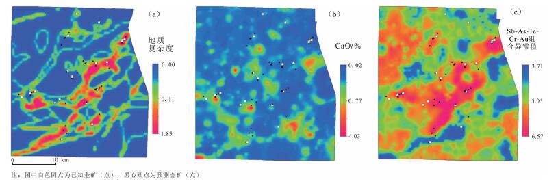
图 9 南非Giyani绿岩带造山带金矿成矿流体运移通道及流体蚀变与矿化[6]
a—地质复杂度图,反映断层、剪切带和岩性接触面等流体运移通道发育程度;b—流体运移通道蚀变岩CaO含量分布图,反映碳酸盐化程度;c—Sb-As-Te-Cr-Au多元素组合异常值分布图,反映流体中Au的沉淀成矿作用程度
Figure 9. Maps of active fluid pathway and fluid-mediated alteration or mineralization for orogenic gold, Giyani greenstone belt, South Africa
-
王涛, 计文化, 胡建民, 等.专题地质填图及有关问题讨论[J].地质通报, 2016, 35(5):633-641. http://dzhtb.cgs.cn/ch/reader/view_abstract.aspx?file_no=20160501&flag=1 蒙义峰, 徐文艺, 杨竹森, 等.流体地质填图—一种新的地质调查方法[J].地质通报, 2002, 21(3):181-182. http://dzhtb.cgs.cn/ch/reader/view_abstract.aspx?file_no=20020356&flag=1 蒙义峰, 侯增谦, 杨竹森, 等.安徽铜陵地区蚀变流体填图方法的探讨[J].地学前缘, 2003, 10(1):105-110. http://d.wanfangdata.com.cn/Periodical_dxqy200301013.aspx 董方浏, 莫宣学, 王勇, 等.云南省巍山-永平矿集区成矿流体地质填图试验重要进展[J].地学前缘, 2001, 8(3):52. http://www.wanfangdata.com.cn/details/detail.do?_type=perio&id=zgdizhi200301008 王勇, 莫宣学, 董方浏, 等.云南巍山永平矿集区流体地质填图的理论与实践[J].中国地质, 2003, 30(1):73-83. http://www.wanfangdata.com.cn/details/detail.do?_type=perio&id=zgdizhi200301008 Carranza E J M, Sadeghi M, Billay A. Predictive mapping of prospectivity for orogenic gold, Giyani greenstone belt (South Africa)[J]. Ore Geology Reviews, 2015, 71:703-718. doi: 10.1016/j.oregeorev.2014.10.030
Amiri M A, Karimi M, Sarab A A. Hydrocarbon resources potential mapping using the evidential belief functions and GIS, Ahvaz/Khuzestan Province, southwest Iran[J]. Arabian Journal of Geosciences, 2015, 8(6):3929-3941. doi: 10.1007/s12517-014-1494-8
Chi G, Lavoie D, Bertrand R. Regional-scale variation of characteristics of hydrocarbon fluid inclusions and thermal conditions along the Paleozoic Laurentian continental margin in eastern Quebec, Canada[J]. Bulletin of Canadian Petroleum Geology, 2000, 48(3):193-211. doi: 10.2113/48.3.193
Badertscher N P, Beaudoin G, Therrien R, et al. Glarus overthrust:A major pathway for the escape of fluids out of the Alpine orogen[J]. Geology, 2002, 30(10):875. doi: 10.1130/0091-7613(2002)030<0875:GOAMPF>2.0.CO;2
Kirschner D L, Masson H, Sharp Z D. Fluid migration through thrust faults in the Helvetic nappes (Western Swiss Alps)[J]. Contributions to Mineralogy & Petrology, 1999, 136(1/2):169-183. doi: 10.1007/s004100050530
Vrolijk P. Tectonically driven fluid flow in the Kodiak accretionary complex, Alaska[J]. Geology, 1987, 15(5):466. doi: 10.1130/0091-7613(1987)15<466:TDFFIT>2.0.CO;2
Goldstein A, Valley J W, Selleck B. Pressure, temperature, and composition history of syntectonic fluids in a low-grade metamorphic terrane[J]. Geology, 2005, 33(5):421. doi: 10.1130/G21143.1
Wiltschko D V, Lambert G R, Lamb W. Conditions during syntectonic vein formation in the footwall of the Absaroka Thrust Fault, Idaho-Wyoming-Utah fold and thrust belt[J]. Journal of Structural Geology, 2009, 31(9):1039-1057. doi: 10.1016/j.jsg.2009.03.009
Cox S F. Deformational controls on the dynamics of fluid flow in mesothermal gold systems[J]. Geological Society London Special Publications, 1999, 155(1):123-140. doi: 10.1144/GSL.SP.1999.155.01.10
Buis E, Temme A J A M, Veldkamp A, et al. Fluid history related to the Alpine compression at the margin of the south-Pyrenean Foreland basin:the El Guix anticline[J]. Tectonophysics, 2000, 321(1):73-102. doi: 10.1016/S0040-1951(00)00090-1
Achel H G M, Cavell P A. Low-flux, tectonically-induced squeegee fluid flow ("hot flash") into the Rocky Mountain Foreland Basin[J]. Bulletin of Canadian Petroleum Geology, 1999, 47(4):510-533. https://www.researchgate.net/publication/241898472_Low-flux_tectonically-induced_squeegee_fluid_flow_hot_flash_into_the_Rocky_Mountain_Foreland_Basin
Rasmussen B, Krapez B. Evidence of hydrocarbon and metalliferous fluid migration in the Palaeoproterozoic Earaheedy Basin of Western Australia[J]. American Ethnologist, 2000, 157(2):355-366. http://jgs.lyellcollection.org/content/157/2/355
Bradley D C, Leach D L. Tectonic controls of Mississippi Valleytype lead-zinc mineralization in orogenic forelands[J]. Mineralium Deposita, 2003, 38(6):652-667. doi: 10.1007/s00126-003-0355-2
Leach D L, Bradley D, Lewchuk M T, et al. Mississippi Valleytype lead-zinc deposits through geological time:implications from recent age-dating research[J]. Mineralium Deposita, 2001, 36(8):711-740. doi: 10.1007/s001260100208
Roure F, Swennen R, Schneider F, et al. Incidence and Importance of Tectonics and Natural Fluid Migration on Reservoir Evolution in Foreland Fold-And-Thrust Belts[J]. Oil & Gas Science & Technology, 2006, 60(60):67-106. https://www.researchgate.net/profile/Nicole_Guilhaumou2/publication/232708857_Incidence_and_Importance_of_Tectonics_and_Natural_Fluid_Migration_on_Reservoir_Evolution_in_Foreland_Fold-And-Thrust_Belts/links/558a6eca08ae2affe7154dab/Incidence-and-Importance-of-Tectonics-and-Natural-Fluid-Migration-on-Reservoir-Evolution-in-Foreland-Fold-And-Thrust-Belts.pdf
Vandeginste V, Swennen R, Faure J L, et al. Paleostress evolution in the Canadian Cordilleran foreland fold-and-thrust belt west of Calgary[J]. Geologica Belgica, 2012, 15(1):42-52. https://lirias.kuleuven.be/handle/123456789/358086
Jolly R J H, Sanderson D J. A Mohr circle construction for the opening of a pre-existing fracture[J]. Journal of Structural Geology, 1997, 19(6):887-892. doi: 10.1016/S0191-8141(97)00014-X
Gudmundsson A. Fluid pressure and stress drop in fault zones[J]. Geophysical Research Letters, 1999, 26:115-118. doi: 10.1029/1998GL900228
Muchez P, Slobodnik M, Viaene W A, et al. Geochemical constraints on the origin and migration of palaeofluids at the northern margin of the Variscan foreland, southern Belgium[J]. Sedimentary Geology, 1995, 96(3):191-200. https://www.sciencedirect.com/science/article/pii/003707389400118E
Nesbitt B E, Muehlenbachs K. Geochemistry of syntectonic crustal fluid regimes along the Lithoprobe southern Canadian Cordilleran transect[J]. Canadian Journal of Earth Sciences, 1995, 32:1699-1719. doi: 10.1139/e95-134
Batartsogt B, Schwinn G, Wagner T, et al. Contrasting paleo fl uid systems in the continental basement:fluid inclusion and stable isotope study of hydrothermal vein mineralization, Schwarzwald district, Germany[J]. Geofluids, 2007, 7:123-147. doi: 10.1111/gfl.2007.7.issue-2
Bons P D, Elburg M A, Gomez-Rivas E. A review of the formation of tectonic veins and their microstructures[J]. Journal of Structural Geology, 2012, 43(43):33-62. https://www.sciencedirect.com/science/article/pii/S0191814112001654
李荣西, 董树文, 丁磊.构造驱动大巴山前陆烃类流体排泄:含烃包裹体纤维状方解石脉证据[J].沉积学报, 2013, 31(3):516-526. http://www.cnki.com.cn/Article/CJFDTOTAL-CJXB201303015.htm 李继宏, 李荣西, 韩天佑.鄂尔多斯盆地西缘马家滩地区地层水与油气成藏关系研究[J].石油实验地质, 2009, 31(3):253-257. doi: 10.11781/sysydz200903253 梁积伟, 李荣西, 陈玉良.鄂尔多斯盆地苏里格气田西部盒8段地层水地球化学特征及成因[J].石油与天然气地质, 2013, 34(5):625-630. doi: 10.11743/ogg20130507 楼章华, 朱蓉.中国南方海相地层水文地质地球化学特征与油气保存条件[J].石油与天然气地质, 2006, 27(5):584-593. doi: 10.11743/ogg20060502 夏林, 车遥, 吕古贤.区域流体地质填图研究中的几个关键问题[J].地学前缘, 2002, 9(4):353-354. http://www.wanfangdata.com.cn/details/detail.do?_type=perio&id=dxqy200204032 Li R X, Liu S W, Dong S W. Characteristics of hydrocarbon fluid inclusions and their significance for evolution of petroleum systems in the Dabashan foreland, Central China[J]. Acta Geologica Sinica, 2015, 89(3):861-875. doi: 10.1111/1755-6724.12484
覃小丽, 李荣西, 董树文, 等.大巴山陆内造山带构造流体及其形成条件研究[J].地学前缘, 2016, 23(4):183-189. http://www.wanfangdata.com.cn/details/detail.do?_type=perio&id=dxqy201604015 Bechtel A, Gratzer R, Püttmann W, et al. Geochemical characteristics across the oxic/anoxic interface (Rote Fäule, front) within the Kupferschiefer of the Lubin-Sieroszowice mining district (SW Poland)[J]. Chemical Geology, 2002, 185(1/2):9-31. https://www.sciencedirect.com/science/article/pii/S0009254101003953
Luca V, Gianni C, Sonia T, et al. Conditions for veining and origin of mineralizing fluids in the Alpi Apuane (NW Tuscany, Italy):Evidence from structural and geochemical analyses on calcite veins hosted in Carrara marbles[J]. Journal of Structural Geology, 2012, 4:76-92. https://www.researchgate.net/publication/258671497_Corrigendum_to_Conditions_for_veining_and_origin_of_mineralizing_fluids_in_the_Alpi_Apuane_NW_Tuscany_Italy_Evidence_from_structural_and_geochemical_analyses_on_calcite_veins_hosted_in_Carrara_marbles
Ferket H, Roure F, Swennen R, et al. Fluid migration placed into the deformation history of fold-and-thrust belts:an example from the Veracruz basin (Mexico)[J]. Journal of Geochemical Exploration, 2000, s69/70(9):275-279. https://www.sciencedirect.com/science/article/pii/S0375674200000704
Fischer M P, Higueradiaz I C, Evans M A, et al. Fracture-controlled paleohydrology in a map-scale detachment fold:Insights from the analysis of fluid inclusions in calcite and quartz veins[J]. Journal of Structural Geology, 2009, 31(12):1490-1510. doi: 10.1016/j.jsg.2009.09.004
Evans M A, Fischer M P. On the distribution of fluids in folds:A review of controlling factors and processes[J]. Journal of Structural Geology, 2012, 44:2-24. doi: 10.1016/j.jsg.2012.08.003
Billi A. Attributes and influence on fluid flow of fractures in foreland carbonates of southern Italy[J]. Journal of Structural Geology, 2005, 27(9):1630-1643. doi: 10.1016/j.jsg.2005.05.001
陈法正.砂岩型铀矿的成矿地质条件与战略选区[J].铀矿地质, 2002, 18(3):138-143. http://industry.wanfangdata.com.cn/yj/Detail/Periodical?id=Periodical_ykdz200203002 肖新建, 李子颖, 陈安平, 等.东胜地区砂岩型铀矿床后生蚀变矿物分带特征初步研究[J].铀矿地质, 2004, 20(2):136-140. http://www.cqvip.com/QK/91728X/2004003/9685822.html 李荣西, 段立志, 陈宝赟, 等.东胜砂岩型铀矿氧化-酸性流体与还原碱性热液流体过度界面蚀变带成矿作用研究[J].大地构造与成矿学, 2011, 35(4):524-531. http://www.cqvip.com/QK/90781X/201104/40071142.html 董树文, 胡健民, 施炜, 等.大巴山侏罗纪叠加褶皱与侏罗纪前陆[J].地球学报, 2006, 27(5):403-410. http://industry.wanfangdata.com.cn/dl/Detail/Periodical?id=Periodical_dqxb200605003 施炜, 董树文, 胡健民, 等.大巴山前陆西段叠加构造变形分析及其应力场特征[J].地质学报, 2007, 81(10):1314-1327. doi: 10.3321/j.issn:0001-5717.2007.10.002 Groves D I, Groves D I, Goldfarb R J, et al. Orogenic gold deposits:a proposed classification in the context of their crustal distribution and relationship to other gold deposit types[J]. Ore Geology Reviews, 1998, 13:7-27. doi: 10.1016/S0169-1368(97)00012-7
Groves D I, Bierlein F P. Geodynamic settings of mineral deposit systems[J]. Journal of the Geological Society of London, 2007, 164:19-30. doi: 10.1144/0016-76492006-065
Sarah H, Tsehaie W, Emmanuel J M, et al. Predictive mapping of prospectivity for orogenic gold in Uganda[J]. Journal of African Earth Sciences, 2014, 99:666-693. doi: 10.1016/j.jafrearsci.2014.03.001
Carranza E J M, Hale M. Evidential belief functions for data-driven geologically constrained mapping of gold potential, Baguio district, Philippines[J]. Ore Geology Reviews, 2003, 22:117-132. doi: 10.1016/S0169-1368(02)00111-7
-
期刊类型引用(4)
1. 刘鹏飞,刘少玉,周晓妮,王哲,张光辉,崔尚进. 华北平原典型区不同砂层井灌中水位水量变化差异特征——以滹沱河冲洪积扇藁城段为例. 科学技术与工程. 2023(02): 502-508 .  百度学术
百度学术
2. 王小江,李培,张凯,荣立新,姜春香,李金丽. 永定河流域新生代地层岩相地震识别. 地质通报. 2023(Z1): 332-342 .  本站查看
本站查看
3. 张梦南,程旭学,李志红,刘伟坡,崔虎群,魏世博,刘伟朋,刘江涛,李永利,陈卓. 三江平原建三江地下水位下降区地面形变监测、评估与预测. 地质通报. 2023(07): 1211-1217 .  本站查看
本站查看
4. 肖都,张强,杜炳锐,袁桂琴,刘建勋,裴发根,李建华,贲放,欧洋,王刚,冯斌,朱威,孙跃. “十一五”以来勘查地球物理发展回顾与展望. 物探化探计算技术. 2022(06): 698-707 .  百度学术
百度学术
其他类型引用(0)


 下载:
下载:


