Application of geometric precision correction based on high-resolution Remote Sensing Image in 1:50000 geological mapping
-
摘要:
高山峡谷区海拔高、切割深,穿越条件极差,借助高分辨率遥感图像开展1:5万区域地质填图工作具有非常重要的意义。然而市场购置的遥感图像产品与实地位置信息和地形图等工作底图不匹配,其几何精度严重制约地质填图野外调查工作。为解决这一现实问题,采用高分辨率遥感图像SPOT7,以青藏高原柴达木盆地北缘赛什腾山为例开展研究,提出一套高分辨率遥感图像几何精校正技术方法。该方法在高分辨率遥感图像融合配准的基础上,创新半自动化人机交互式地面控制点选取方法,以及典型特征控制点海量选取、空间均匀分布等技术,通过对校正后遥感图像几何精度的反复检查提升,实现了高分辨率遥感图像的几何精校正。该方法校正后的遥感图像充分发挥了遥感技术的先导作用,极大地提高了野外地质填图的工作效率,可为地形复杂地区高分辨率遥感图像几何精校正提供技术参考。
Abstract:The high resolution remote sensing images can play an important role in the 1:50000 geological mapping in the alpine-gorge area with high altitude, deep cutting and poor crossing conditions.However, the remote sensing image products provided by the current market cannot match the working base maps such as field position information and topographic maps, and their geometric accuracy seriously restricts the field investigation of geological mapping.In order to solve this practical problem, a set of geometric precision correction techniques for high resolution remote sensing images is proposed by using high resolution remote sensing image SPOT7 and exemplifying Saishiteng Mountain in the northern margin of Qaidam Basin in Qinghai-Tibet Plateau as an example.Based on the fusion registration of high-resolution remote sensing images, this method innovates the semi-automatic man-machine interactive ground control point selection method, as well as the techniques of mass selection and spatial uniform distribution of typical feature control points.Through repeatedly checking and improving the geometric accuracy of corrected remote sensing images, the geometric precision correction of high-resolution remote sensing images is realized.The corrected remote sensing images give full play to the leading role of remote sensing technology, greatly improve the efficiency of field geological mapping, and can provide technical reference for geometric precision correction of high resolution remote sensing images in complex terrain areas.
-
高山峡谷区海拔高、切割深,穿越条件极差,在1:5万区域地质填图中,有大量野外工作人员难以到达的地区[1-2]。现今遥感图像的分辨率越来越高,遥感图像成为地质填图方面一个重要的信息源,遥感技术成为地质填图工作中一种重要的勘查方法,遥感技术可为高山峡谷区1:5万区域地质填图提供支撑[3-6]。但是,遥感图像应用之前需进行几何校正,使遥感图像与实地位置精确配准,才能利用校正后的精准高分辨率遥感图像进行野外填图[7]。张婷等[8]提出对SPOT5的几何校正方法,其研究区主要涉及平原区、丘陵区和少量山区,控制点的采集选用野外GPS采点,对于高山峡谷区没有涉及。陈静等[9]利用重庆市主城区DEM对Worldview影像正射校正,其控制点和检查点采用GPS-RTK野外实测,校正后影像存在不同程度的扭曲变形,对于高山峡谷区同样没有涉及。屈为刚[10]基于ENVI软件对中高山区的SPOT5进行正射校正方法初探,但没有详细地讨论控制点选取和精度检查等关键问题。蓝晓丹等[11]基于不同地面控制点采集方法对林区的SPOT5图像几何精校正精度的影响进行了研究,发现很难在地形图和遥感图像上选取同名地物点。梳理前人研究成果,结合青藏高原柴达木盆地北缘赛什腾山1∶5万区域地质填图项目的实践可知,高分辨率遥感图像的几何校正精度非常重要,是制约高分辨率遥感图像应用于1:5万区域地质填图的关键。其中技术的难点在于高山峡谷区人工地物稀少,难以在地形图和遥感图像上选取同名地物点进行高分辨率遥感图像的几何精校正。鉴于此,本文采用高分辨率遥感图像SPOT7,以青藏高原柴达木盆地北缘赛什腾山为例,探索采用1:5万标准地形图对高山峡谷区高分辨率遥感图像SPOT7进行几何精校正的方法,详细讨论地面控制点选取和精度检查等关键问题。
1. 研究区地形特征
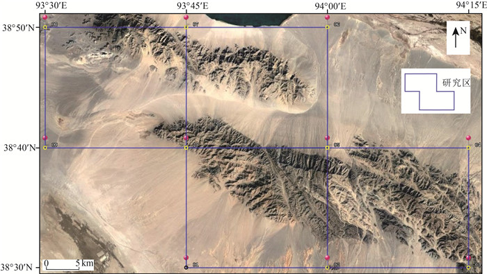
青藏高原柴达木盆地北缘赛什腾山一带,区内山势陡峻,山脉横亘呈北西走向,切割强烈,峰峦叠嶂,沟谷发育,地势险峻,属强烈剥蚀的构造高山区。地势北西高、南东低。区内西南部为高原低山丘陵地带,属柴达木盆地,多为戈壁及沙漠,地形较复杂,山区一般海拔3200~3900 m,最高峰赛什腾山4006 m,相对高差400~600 m,最大高差1300 m[12-13](图 1)。
2. 采用的数据与处理
本文以赛什腾山为研究区,采用购置的高分辨率遥感图像SPOT7数据和1:5万地形图开展研究。总体思路是,以1:5万地形图为标准图,加载1:5万地形图生成的DEM数据,基于ERDAS遥感图像处理平台对高分辨率遥感图像半自动化人机交互式选取地面控制点,进行几何精校正。1:5万地形图为2000年后获取的数据所更新,采用2000国家大地坐标系、高斯-克吕格投影、1985国家高程基准,由中国地质调查局西安地质调查中心提供。
目前SPOT系列卫星已经发射7颗,确保了SPOT卫星服务的连续性。SPOT6卫星于2012年9月9日发射成功,SPOT7卫星于2014年6月30日发射成功。SPOT6/7双子星座可对地球任意地点实现1天重访。SPOT6/7空间分辨率:全色1.5 m和多光谱波段6 m;波长分别是:全色(0.455~0.745 μm),蓝(0.455~0.525 μm),绿(0.530~0.590 μm),红(0.625~0.695 μm),近红外(0.760~0.890 μm);宽幅:60 km×60 km。实现了全色波段与多光谱波段图像无误差配准,配准精度非常高[14]。研究采用的遥感数据编号为SEN_SPOT7_20180324_041607300_000,时相为2018-03-24 04:16:06.2。全色波段为IMG_SPOT7_P_001_A: SPOT7 2018-03-24 04:16:06.2 SENSOR P;多光谱波段为IMG_SPOT7_MS_001_A: SPOT7 2018-03-24 04:16:06.2 SENSOR MS。观察发现,其多光谱波段与全色波段获取数据时间处于同一时间,都是2018-03-24 04:16:06.2,无需对多光谱与全色波段进行图像对图像的配准工作,SPOT7可以实现多光谱与全色波段快速直接融合,生成分辨率为1.5 m的4个波段多光谱图像,以备几何精校正使用。
3. 几何精校正的若干关键问题研究分析
3.1 典型特征控制点选取
对于自然地理环境恶劣,人员难以进入、海拔高深切割区,1:5万区域地质填图工作势必要借助遥感图像[7]。遥感图像的几何精校正成功与否,对后续的处理和分析相当重要,因校正后的精准遥感图像才能对图像信息进行各种分析,制作满足量测和定位要求的各类地球资源及环境的遥感专题图[8, 11, 15]。高山峡谷区高分辨率遥感图像几何精校正的关键就是地面控制点选取。高山峡谷区人烟稀少,房屋、道路、桥梁或水库坝址等基础设施很少,因此,对于在高山峡谷区的高分辨率遥感图像,选取同名地面控制点,就显得非常困难,甚至无法实现[8, 16-17]。杨国栋等[18]采用RTK动态测量外作业实测点作为检查点对全色与多光谱影像进行了无控制点的正射校正,但是RTK在高山峡谷区外作业也非常困难。
典型特征控制点选取的实质是如何以1:5万地形图和1:5万地形图生成的DEM数据为标准,在高分辨率遥感图像上找到同名地物点。据此,确定了选取同名地物点的选点原则:①观察并熟悉工作区地形图与遥感图像,研究分析确定选择典型特征同名控制点的类型,确保地形图上的点与遥感图像的点一一对应。②在缺少典型人工地物同名控制点的前提下,多选山顶,如等高线圈闭并标有数字处,将控制点选择在山顶或山脊交叉点,一般山顶或山脊交叉点不会发生改变,除非人工开挖;尽量少选河流,沟谷,因为地形图制作时间与遥感图像成像时间不一致,遥感图像离现今比较近,而地形图较早,河流容易改道,导致选择河流拐弯的点不准确。③先易后难,在准确确定前3个控制点的基础上,利用好软件的预测辅助功能快速高效选点;在1:5万地形图中,先由北向南或由东到西顺序,1~2 km范围内加一个控制点,等到第4个点后就可以采用预测(Predict)点的位置。特别要强调的是,对预测的地面控制点,要进行对应准确位置的微调。该种预测点操作方法简单,基本是半自动化人机交互式完成。④一定要注意控制点是否均匀分布、控制点是不是同名控制点、控制点的位置、在地形图和遥感图像上位置是否一一对应。
3.2 典型特征控制点海量选取统筹协调
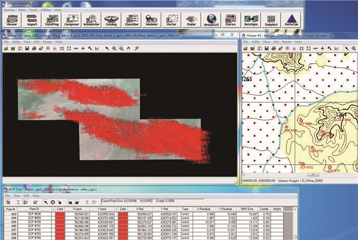
一是典型特征控制点的空间分布问题,二是海量特征控制点的误差控制问题。最终整幅图基本上选完点后,在误差处一定要注意贡献误差数值(Contribute),如果发现哪一个控制点贡献值太大,就要尽量在其周围多加控制点,将误差降下来,最后将这个贡献误差值大的点删除,本次研究的贡献误差小于1。总误差(Total)尽量保持在20 m以下,本文是13.925 m(图 2),对于1:5万区域地质填图工作,地质图上就是0.2785 mm,而一般手图比例尺是1:2.5万,地质图上就是0.557 mm,没有超过1 mm,完全满足1∶5万区域地质调查地质填图技术标准规范[7]。这样就可以运行ERDAS 9.2软件进行1:5万地形图与遥感图像几何精校正。
3.3 校正后遥感图像几何精度的检查
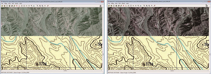
野外地质工作人员经常用到高分辨率的遥感图像,不知怎样检查遥感图像的精度,有时将野外地质GPS作业点投到遥感图像上,发现遥感图像的误差甚至达100 m,这样的遥感图像不能展现遥感技术的优势。因此,校正后的遥感图像精度检查非常重要,本文介绍2种简单易操作的检查校正后遥感图像的精度方法。一种方法是通过卷帘工具检查对比校正前与校正后的图像SPOT7与1:5万地形图套合情况(图 3)。采用ERDAS 9.2软件在一个窗口同时打开遥感图像SPOT7和1:5万地形图,将叠合的2张图通过卷帘工具(Swipe)检查其套合情况。以1:5万地形图的3条河流(以左中右表示)为标志检查点,图 3-a是校正前的SPOT7图像,图 3-b是校正后的SPOT7图像。可以发现,校正前的SPOT7图像3条河流与1:5万地形图纬向上实际位置都有很大的误差,通过校正前的SPOT7图像(图 3-a)检查发现,左、中和右河流与1:5万地形图实际横向位置分别相差78 m、134 m和122 m,而且可以看出1:5万地形图上的河流在遥感图像上位于山坡上,这与实际位置不符。相比之下,校正后的SPOT7图像3条河流与1:5万地形图实际位置误差很小,分别为12.9 m、14.2 m、13.6 m,而且校正后的SPOT遥感图像上的河流与1:5万地形图上的河流位置基本匹配准确。
另一种方法是将校正后的SPOT7图像通过mapGIS软件转换成MSI格式,添加到1:5万数字地形图工程文件中,将其与1:5万地形图叠合用光标十字查看其校正精度,在此不赘述。这2种检查方法能够帮助野外地质工作人员快速高效地检查出校正后的遥感图像是否符合项目要求。
3.4 校正前后SPOT7图像在野外地质调查中的应用
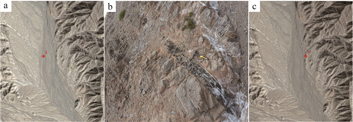
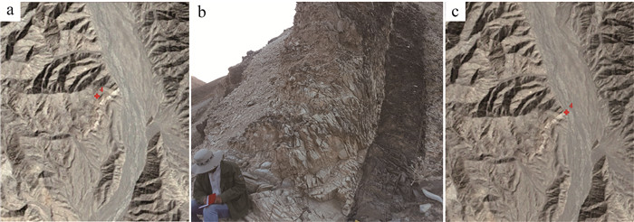
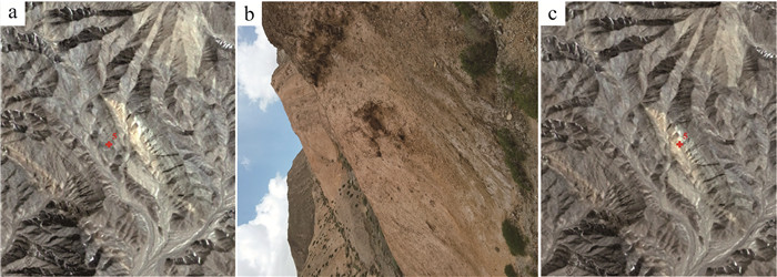
2019年笔者所在课题组进行了野外实地踏勘区域地质调查工作,此次均匀抽取10个野外地质典型露头GPS点(表 1;图 4)。图 5、图 6和图 7分别是SH03点处、SH04点处和SH05点处,包括校正前的SPOT7图像、GPS点处野外露头和校正后的SPOT7图像。可以发现,经校正后的SPOT7图像与野外实际位置匹配非常准确,能很好地在遥感图像上勾画出地质体及地质界线,而校正前的SPOT7图像与野外地质体实际位置相差太远,不能在此遥感图像上勾画地质界线。项目野外实践显示,经校正后的精准遥感图像可以和1:5万地形图一起作为手图使用,直接在其上进行实际填图工作,大大地提高了工作效率,减少了野外工作艰苦程度。同时可以进一步对图像信息进行各种分析,制作满足测量和定位要求的各类地球资源及环境的遥感专题图。
表 1 研究区野外典型露头点坐标Table 1. Coordinates of the typical outcrops in the study area点号 X Y 典型露头 SH01 E93°48′33.8652" N38°36′34.488" 灰绿色中细粒辉长-闪长岩脉宏观特征 SH02 E93°53′16.0152" N38°39′11.898" 灰色中粗粒片麻状石英闪长岩及其中发育的浅肉红色中细粒正长花岗岩脉 SH03 E93°55′22.6344" N38°36′15.6888" 中粗粒钾化花岗岩脉,晚期的细粒辉长岩侵入其中 SH04 E93°55′44.436" N38°34′57.36" 灰白色花岗细晶岩脉宏观特征 SH05 E93°57′22.1436" N38°36′54.7056" 灰白色细晶花岗岩脉特征 SH06 E93°57′40.8024" N38°35′5.928" 灰黑色石英片岩与大理岩接触部位 SH07 E93°58′30.2484" N38°35′21.1884" 黄色云母片岩夹灰绿色绿泥石英片岩 SH08 E93°59′43.8432" N38°38′34.5444" 灰黑色中粒辉长岩及其中发育的大理岩透镜体 SH09 E93°59′40.1172" N38°32′21.3036" 灰褐色黑云斜长片麻岩中的浅色脉体,发育揉流褶皱 SH10 E93°59′53.4876" N38°35′55.5252" 灰绿色中细粒闪长岩宏观(硅化、褐铁矿化强烈) 4. 结果和讨论
经本次几何精校正后的遥感图像,能完全满足1∶5万区域地质调查地质填图技术标准规范[7],从而解决了高山峡谷区地质填图几何精校正问题。对于校正后的图像精度检查的2种方法也易于操作,能够帮助野外地质填图一线工作人员快速高效地检查出校正后的遥感图像是否符合项目要求。项目实践显示,经校正后的精准遥感图像可配合1:5万地形图,直接应用于实际填图工作,直观清晰并提高了工作效率。同时可以进一步对图像信息进行各种分析,制作满足要求的各类遥感专题图。
高山峡谷区基础设施很少,值得一提的是,高山峡谷区高分辨率遥感图像几何精校正的关键就是地面控制点选取。本次研究提出典型特征控制点选取四步原则:①地形图上的点与遥感图像的点是否一一对应;②选取山顶或者山脊交叉点作为控制点;③半自动化人机交互式快速高效海量选取控制点;④控制点空间均匀分布。这四步缺一不可。同时校正后遥感图像几何精度的检查也必不可少。
5. 结论
通过研究提出一套适合高山峡谷区1:5万区域地质填图高分辨率遥感图像几何精校正技术,创新半自动化人机交互式地面控制点选取方法,以及典型特征控制点海量选取、空间均匀分布等技术,通过对校正后遥感图像几何精度的反复检查提升,实现了高分辨率遥感图像的几何精校正。在青藏高原柴达木盆地北缘赛什腾山1:5万区域地质填图工作中,几何精校正后的SPOT7高分辨率遥感图像充分发挥了遥感技术的先导作用,极大地提高了野外地质填图的工作效率。该研究可为地形复杂地区高分辨率遥感图像几何精校正提供技术参考,对提高该类地区地质填图效率有重要的意义。
-
表 1 研究区野外典型露头点坐标
Table 1 Coordinates of the typical outcrops in the study area
点号 X Y 典型露头 SH01 E93°48′33.8652" N38°36′34.488" 灰绿色中细粒辉长-闪长岩脉宏观特征 SH02 E93°53′16.0152" N38°39′11.898" 灰色中粗粒片麻状石英闪长岩及其中发育的浅肉红色中细粒正长花岗岩脉 SH03 E93°55′22.6344" N38°36′15.6888" 中粗粒钾化花岗岩脉,晚期的细粒辉长岩侵入其中 SH04 E93°55′44.436" N38°34′57.36" 灰白色花岗细晶岩脉宏观特征 SH05 E93°57′22.1436" N38°36′54.7056" 灰白色细晶花岗岩脉特征 SH06 E93°57′40.8024" N38°35′5.928" 灰黑色石英片岩与大理岩接触部位 SH07 E93°58′30.2484" N38°35′21.1884" 黄色云母片岩夹灰绿色绿泥石英片岩 SH08 E93°59′43.8432" N38°38′34.5444" 灰黑色中粒辉长岩及其中发育的大理岩透镜体 SH09 E93°59′40.1172" N38°32′21.3036" 灰褐色黑云斜长片麻岩中的浅色脉体,发育揉流褶皱 SH10 E93°59′53.4876" N38°35′55.5252" 灰绿色中细粒闪长岩宏观(硅化、褐铁矿化强烈) -
张进, 曲军峰, 张庆龙, 等. 基岩区构造地质填图方法思考、实践、探索[J]. 地质通报, 2018, 37(2/3): 192-221. http://dzhtb.cgs.cn/gbc/ch/reader/view_abstract.aspx?file_no=2018020302&flag=1 黄理善, 李学彪, 荆林海, 等. 基于遥感技术的高寒山区矿产资源远景区快速圈定与综合评价技术集成[J]. 中国地质, 2020-02-10, 网络首发论文. https:kns.cnki.net/kcms/detail/11.1167.P.20200210.1631.002.html. 李娜, 董新丰, 甘甫平, 等. 高光谱遥感技术在基岩区区域地质调查填图中的应用[J]. 地质通报, 2021, 40(1): 13-21. http://dzhtb.cgs.cn/gbc/ch/reader/view_abstract.aspx?file_no=20210102&flag=1 李永胜, 张生辉, 张彤, 等. 1: 50000矿产地质图编制与数据库建设要求[J]. 中国地质, 2020, 47(S2): 1-15. doi: 10.12029/gc2020Z201 陈圆圆, 候德华, 潘志龙, 等. 典型地区基础地质图智能编图实践——以北山地区1: 25万甜水井幅为例[J]. 地质通报, 2021-01-21, 网络首发论文. https://kns.cnki.net/kcms/detail/11.4648.P.20210121.1054.004.html. 黄辉, 路彥明, 李仰春, 等. 基于多元知识和编图模型的智能地质编图技术及其应用[J]. 地质通报, 2021-01-20, 网络首发论文. https://kns.cnki.net/kcms/detail/11.4648.P.20210120.1056.004.html. 辜平阳, 陈瑞明, 查显峰, 等. 高山峡谷区1: 50000地质填图技术方法探索与实践——以新疆乌什北山为例[J]. 地质力学学报, 2016, 22(4): 837-855. doi: 10.3969/j.issn.1006-6616.2016.04.004 张婷, 刘军, 骆慧琴. 1: 1万DEM的生成及SPOT-5卫星数据正射校正[J]. 遥感技术与应用, 2004, 19(5): 420-423. doi: 10.3969/j.issn.1004-0323.2004.05.025 陈静, 袁超, 陈雪洋, 等. DEM对山区高分辨率影像正射校正精度的影响[J]. 地理空间信息, 2014, 12(1): 128-131. doi: 10.11709/j.issn.1672-4623.2014.01.044 屈为刚. ENVI软件制作SPOT5遥感正射影像图方法初探[J]. 山西建筑, 2014, 40(21): 223-225. https://www.cnki.com.cn/Article/CJFDTOTAL-JZSX201421120.htm 蓝晓丹, 李春干, 杜海波. 不同地面控制点采集方法对SPOT5图像几何精校正精度的影响[J]. 中南林业调查规划, 2009, 28(3): 31-35. https://www.cnki.com.cn/Article/CJFDTOTAL-ZLDF200903010.htm 高万里, 王宗秀, 李磊磊, 等. 柴达木盆地北缘小赛什腾山二叠纪花岗岩的发现及其构造意义[J]. 地质力学学报, 2019, 93(4): 816-829. https://www.cnki.com.cn/Article/CJFDTOTAL-DZXE201904005.htm 和政军, 许志琴, 杨经绥, 等. 柴达木盆地北缘小赛什腾山晚古生代放射虫的发现及其意义[J]. 地质通报, 2002, 21(3): 156-157. http://dzhtb.cgs.cn/gbc/ch/reader/view_abstract.aspx?file_no=20020349&flag=1 杨亚莉, 赵宁, 成晓倩. 基于FLAASH模型的SPOT6卫星影像大气校正及评价[J]. 现代测绘, 2015, 38(2): 3-9. https://www.cnki.com.cn/Article/CJFDTOTAL-JSCH201502001.htm 田淑芳, 詹骞. 遥感地质学[M]. 北京: 地质出版社, 2013. 高晖. 不同精度控制点对遥感图像几何校正的影响[D]. 中国地质大学硕士学位论文, 2008. 钟婷, 杨敏华. 高山区遥感影象与地形数据几何配准试验研究[J]. 内蒙古林学院学报(自然科学版), 1999, 21(1): 76-81. https://www.cnki.com.cn/Article/CJFDTOTAL-NMGL901.016.htm 杨国东, 赵强, 张旭晴, 等. 基于SPOT6卫星遥感数据无控制点正射校正[J]. 测绘与空间地理信息, 2018, 41(7): 1-3. https://www.cnki.com.cn/Article/CJFDTOTAL-DBCH201807001.htm -
期刊类型引用(8)
1. 赵利芬,常晓通. SAR图像增强的建筑基坑底面下沉风险监测仿真. 计算机仿真. 2023(09): 291-295 .  百度学术
百度学术
2. 冯乾文. 复杂造山带多尺度构造变形的观测方法——来自南天山库米什地区研究的启示. 地质通报. 2023(10): 1706-1717 .  本站查看
本站查看
3. 程三友,王曦,李永军,王冉. 多源遥感数据在西准噶尔哈拉阿拉特山地区1∶5万地质填图中的对比研究. 地质力学学报. 2022(01): 143-154 .  百度学术
百度学术
4. 周恩生,魏维轩,王南. 城市公园碳汇计量中RTK多光谱遥感技术的应用研究. 现代园艺. 2022(09): 47-49 .  百度学术
百度学术
5. 李发森,李显巨,陈伟涛,董玉森,李雨柯,王力哲. 基于深度特征的双极化SAR遥感图像岩性自动分类. 地球科学. 2022(11): 4267-4279 .  百度学术
百度学术
6. 邹键,唐文龙,王凤华,胡峰,薄军委,王志新,刘治,魏绪峰,李勇. 高分遥感数据在胶东水道地区金成矿远景区圈定中的应用研究. 地质论评. 2022(06): 2336-2348 .  百度学术
百度学术
7. 林海星,程三友,王曦,陈静,辜平阳,庄玉军,赵欣怡,马刚. 青海赛什腾地区遥感影像岩石信息提取研究. 地质论评. 2022(06): 2319-2335 .  百度学术
百度学术
8. 苗晓岐. 多源遥感技术在藏东南艰险复杂山区泥石流物源识别中的应用. 地质通报. 2021(12): 2052-2060 .  本站查看
本站查看
其他类型引用(3)


 下载:
下载:
