
Effect of geological mapping in shallow overburden area of East Junggar, Xinjiang Province: A case of bedrock geological mapping in the Dure shallow overburden area
-
摘要:
如何“剥离”盖层,以获取盖层下伏基岩地质(地层、岩浆岩、构造)及矿化信息是开展成矿带浅覆盖区地质填图的重要研究内容。结合区域地质及地球物理场特征,梳理了填图区与基岩地质填图有关问题,在填图区岩石物性分析的基础上,通过对1:5万重力、磁力和激电(IP)测量数据处理分析,采用多参数互约束解释技术和钻探验证约束技术“剥离”盖层,进而获得杜热一带覆盖区下伏基岩地质图,并提出以“穿透性”地球物理探测技术(重磁电)为先导,融合地质、地球化学、浅钻为一体的综合调查技术。在填图区新识别隐伏岩体43处(包括中酸性岩体18处,中基性岩体21处, 基性—超基性岩体4处),划分主要断裂构造22条,进而划分出阿尔曼太-扎河坝蛇绿混杂岩带、北部萨吾尔—二台古生代复合岛弧带和南部谢米斯台-库兰喀孜干古生代复合岛弧带3个三级地质构造分区;划分出奥依达格-吉勒库木铜金钴、铬铁矿找矿远景区1处,圈定找矿靶区4处,其中位于阿尔曼太-扎河坝蛇绿混杂岩带西延带的浅覆盖区玉塔斯铜金钴找矿靶区具有很好的找矿潜力。通过地球物理解译和钻探验证,成功预测并新发现准格尔北缘盆山结合带扎河坝-阿尔曼太蛇绿混杂岩带向西部浅覆盖区延伸。杜热一带浅覆盖区基岩地质填图效果表明,开展成矿带浅覆盖区基岩地质填图可为区域构造环境、成矿地质背景研究和找矿靶区预测提供重要基础地质和矿化蚀变信息。
Abstract:How to "peel off " the cover to obtain the underlying bedrock geology (strata, magmatic rock and structure)and mineralization information is an important research content of geological mapping in shallow overburden area of metallogenic belt.Combined with the characteristics of regional geology and geophysical field, the problems related to the mapping area and bedrock geological mapping were sorted out.Based on the physical property analysis of the mapping area, through the processing and analysis of 1:50000 gravity, magnetic and IP measurement data, the multi-parameter mutual constraint interpretation technique and drilling verification were used to peel off the overburden, and then the underlying bedrock geological map of the Dure overburden area was obtained.Meanwhile, a comprehensive investigation technology guided by "penetrating" geophysical technology (gravity, magnetism, and electricity), integrating geology, geochemistry and shallow drilling was proposed.In this paper, 43 concealed plutons and 22 faults in the mapping area were recognized, including 18 intermediate-acid plutons, 21 medium-basic plutons and 4 basic-ultrabasic plutons.Three 3-order geological tectonic zones were divided, namely Aermantai-Zhahaba ophilitic melange belt, Sawur-Ertai Paleozoic composite island arc belt in the north, and Xiemistai-Kulankazigan Paleozoic composite island arc belt in the south.The Aoyidage-Jilekumu Cu-Au-Co-Fe prospect was determined, in which 4 ore prospects were delineated.Among ore prospects, the Yutasi Cu-Au-Co target area in the west of Aermantai-Zhahaba ophilitic melange belts exhibits agreeable prospecting potential.Through geophysical interpretation and drilling verification, it was successfully predicted and confirmed that the Aermantai-Zhahaba ophilitic melange belt on the basin-mountain junction belt in the northern margin of Jungar extends to the shallow coverage area in the west.The geological mapping of batholith in the Dure shallow coverage area can provide the important basic geological and mineralized alteration information for the regional tectonic environment, metallogenic geological backgrounds and predictions of ore prospects.
-
作为古洋壳和上地幔构造就位至大陆边缘的产物[1-3],蛇绿岩记录了古大洋形成、演化与消亡的信息[4]。它们在碰撞型和增生型造山带中普遍产出,并作为闭合后的板块或增生地体构造界线的主要标志[5],在重建一个地区区域演化中扮演着十分重要的角色。
狮泉河-纳木错-嘉黎缝合带是由蛇绿岩套、构造混杂岩块组成的蛇绿混杂岩带,北西自狮泉河,向南东经拉果错、阿索、格仁错、申扎永珠、纳木错西,再向东经九子拉、凯蒙、波密等地,在拉萨地体北部呈北西—南东向延伸约上千千米[6-7]。作为狮泉河-纳木错-嘉黎缝合带的一部分,拉果错蛇绿岩是缝合带中出露最完整的蛇绿岩组合之一,对恢复和反演该缝合带代表的洋盆演化具有重要的意义。目前,关于拉果错蛇绿岩的形成时代存在不同见解,已知的同位素年龄区间为190~124 Ma[8-10],横跨侏罗纪—白垩纪。此外,关于拉果错蛇绿岩形成的构造环境观点同样存在分歧。西藏地质矿产局[11]认为该蛇绿岩是洞错蛇绿岩的构造推覆体;樊帅权等[10]、王保弟等[12]认为其形成于俯冲带上的构造环境;张玉修等[9]认为其为班公湖-怒江缝合带的一个分支。
基于此,本文选择拉果错蛇绿岩中斜长花岗岩及与之伴生的基性岩类(辉长岩、辉绿岩及辉绿玢岩)为研究对象,通过详细的岩石学、锆石U-Pb年代学和地球化学研究,确定该区蛇绿岩的形成时代与岩石成因,并通过区域地质资料对比,约束狮泉河-纳木错-嘉黎缝合带所代表的洋盆性质。
1. 区域地质背景及岩石学特征
研究区位于西藏改则县以南拉果错地区,大地构造位置处于狮泉河-纳木错-嘉黎缝合带中段(图 1)。区内地层主要为上石炭统—下二叠统拉嘎组(C2P1l)、中二叠统下拉组(P2x)、下白垩统罗玛组(K1lm)和郎山组(K1l)。其中,拉嘎组岩性以粉砂岩、细砂岩、含砾砂岩、板岩及少量石英砂岩为主,夹少量灰岩。下拉组岩性主要为细晶白云岩、生物碎屑灰岩和生物碎屑泥晶灰岩,局部夹灰色细砂岩、板岩,硅质条带灰岩、角砾状灰岩等,在生物碎屑灰岩中,发育大量的珊瑚等生物化石。罗玛组岩性以碎屑岩与碳酸盐岩的韵律性沉积为主,局部见火山岩夹层。郎山组岩性较单一,以生物碎屑灰岩为主。
![]() 图 1 西藏中部拉果错地区地质简图Figure 1. Simplified geological map of Lhaguo Tso area, central Tibet
图 1 西藏中部拉果错地区地质简图Figure 1. Simplified geological map of Lhaguo Tso area, central Tibet区内中酸性岩浆岩较发育,岩性以花岗闪长斑岩、石英钠长斑岩、花岗斑岩和花岗闪长岩为主,直接侵入于拉果错蛇绿岩中。
拉果错蛇绿岩是本文研究的重点,其分布面积较广,岩石端元较齐全。在前人研究的基础上,本文经过详细的路线调查,初步明确拉果错蛇绿岩能识别的岩石端元包括超基性岩、堆晶辉长岩、基性岩墙、枕状熔岩、斜长花岗岩、放射虫硅质岩等,与现今大洋岩石圈的岩石组合可以对比,表明拉果错蛇绿岩应为典型的古洋壳残片。拉果错蛇绿岩各岩石端元详细的岩石学特征描述如下。
超基性岩:主要包括变质橄榄岩(图版Ⅰ-a、e)、强蚀变辉橄岩、单辉橄榄岩、斜辉橄榄岩、橄榄辉石岩、异剥辉石岩等不同岩石端元,可见到较多的全蚀变(碳酸盐化)超基性岩。
![]() 图版Ⅰa.斜长花岗岩侵入超基性岩;b.斜长花岗岩侵入辉绿岩;c.堆晶辉长岩;d.枕状玄武岩;e.蛇纹石化橄榄岩;f.辉绿岩;g.辉绿玢岩;h.斜长花岗岩。Px—辉石; Pl—斜长石; Chl—绿泥石; Am—角闪石; Ab—钠长石; Ep—绿帘石; Srp—蛇纹石; Q—石英图版Ⅰ.
图版Ⅰa.斜长花岗岩侵入超基性岩;b.斜长花岗岩侵入辉绿岩;c.堆晶辉长岩;d.枕状玄武岩;e.蛇纹石化橄榄岩;f.辉绿岩;g.辉绿玢岩;h.斜长花岗岩。Px—辉石; Pl—斜长石; Chl—绿泥石; Am—角闪石; Ab—钠长石; Ep—绿帘石; Srp—蛇纹石; Q—石英图版Ⅰ.堆晶辉长岩:是拉果错蛇绿岩的主要组成部分,野外表现为白色的“斜长岩”和灰黑色的“辉石岩”、“辉长岩”等交替成层出现(图版Ⅰ-c),镜下主要见斜长石、辉石等矿物组成。
基性岩墙:包括辉长岩、辉绿岩、辉绿玢岩等,是本文研究的重点。与堆晶辉长岩不同的是,基性岩墙呈致密块状,未见堆晶结构。辉长岩主要由斜长石(约40%)和辉石(约60%)组成,辉长结构,块状构造,其中斜长石呈半自形板状,聚片双晶发育;辉石呈半自形柱状,部分颗粒发生纤闪石化,粒径大小与斜长石相当。辉绿岩主要由斜长石(约60%)、辉石(15%)和绿泥石(约15%)组成,另见少量金属矿物(约8%),其中斜长石呈自形-半自形板状,部分发生绢云母化及碳酸盐化,聚片双晶发育;辉石多呈粒状,绿泥石呈鳞片状,分布于斜长石颗粒之间搭建的三角形空隙中;金属矿物多呈粒状,分布于粒间孔隙中(图版Ⅰ-b、f)。辉绿玢岩呈斑状结构,分为斑晶(约7%)和基质两部分,其中斑晶主要由斜长石组成,基质主要由斜长石(约55%)、角闪石(约35%)和少量金属矿物(约3%)组成(图版Ⅰ-g)。
斜长花岗岩:呈脉状侵入于辉橄岩和辉绿岩中,侵入接触关系明显(图版Ⅰ-a、b)。镜下显示其主要由钠长石(约48%)和石英(约40%)组成,次为绿泥石(约6%)及绿帘石(约1%),另见绿帘石脉(约5%)。钠长石主要呈粒状,聚片双晶发育,粒径多介于0.05~0.35 mm之间。石英呈他形粒状,粒径大小与钠长石相当。绿泥石系暗色矿物蚀变而来,呈鳞片状,分布于钠长石和石英颗粒之间。绿帘石呈粒状,分布于粒间空隙中。岩石中见绿帘石脉穿插分布,脉体中绿帘石呈微粒状集合体(图版Ⅰ-h)。
枕状熔岩:具典型的枕状构造,由于构造的影响,枕状玄武岩一般较破碎(图版Ⅰ-d)。岩石主要由斜长石、绿泥石、方解石组成;另见不超过5%的杏仁体,典型的填间(间片、间粒)结构,块状-杏仁状构造。斜长石大部分为板条状,粒径多在0.025~0.27 mm之间。绿泥石为绿色,多色性可见。方解石为微粒状,粒径在0.1 mm以下。杏仁体较少,圆形或不规则状,大小0.15~1 mm,主要由石英或石英、绿泥石或石英、方解石充填。岩石中见方解石细脉穿插,脉宽一般小于0.2 mm。
硅质岩:岩石呈深绿灰色,具微晶结构、块状构造,并见次生钠长石脉。岩石主要由硅质及泥质组成,具含泥质微晶结构,并发育次生裂隙,局部见硅化石英脉。岩石中硅质多为隐晶-微晶,粒径0.005 mm左右,其间混杂少量粘土质,局部呈细纹状富集,并弥漫尘状铁炭质,局部见粘土质重结晶为绢(水)云母等。
2. 分析方法
2.1 全岩地球化学
为探讨拉果错蛇绿岩的构造背景,本文采集了拉果错蛇绿岩中的6件辉长岩、3件辉绿岩、5件辉绿玢岩及3件斜长花岗岩样品进行了全岩地球化学分析。全岩主量、微量元素分析在西南冶金地质测试所完成。其中主量元素测试分析方法为重量法、X射线荧光法、滴定法,采用荷兰帕纳科Axios X荧光射线光谱仪测定,分析误差小于5%;微量元素测试分析方法为等离子发射光谱法、X荧光光谱法,采用美国THEROM公司生产的iCAP6300全谱直读等离子发射光谱仪测定,当元素含量大于10×10-6时,精度误差小于5%;含量小于10×10-6时,误差小于10%。
2.2 锆石U-Pb同位素测定
为确定拉果错蛇绿岩的形成时代,本文选取其中的斜长花岗岩样品进行锆石U-Pb定年。锆石U-Pb同位素定年分析在中国地质大学(武汉)地质过程与矿产资源国家重点实验室(GPMR)完成,激光剥蚀系统为GeoLas 2005,ICP-MS为Agilent 7500a。实验中激光波长193 nm、束斑32 μm、脉冲频率6 Hz;采用锆石标准91500为外标进行U-Pb同位素分馏校正,并利用91500的变化采用线性内插的方式对U-Th-Pb同位素比值漂移进行了校正。采用ICPMSDTACAL程序离线处理分析数据,详细的仪器操作条件和数据处理方法见参考文献[13],采用Isoplot/Ex(3.0版)绘制U-Pb谐和图绘制及年龄加权平均计算。
3. 分析结果
3.1 岩石地球化学
辉长岩、辉绿岩、辉绿玢岩和斜长花岗岩全岩主量、微量和稀土元素分析结果见表 1。
表 1 拉果错蛇绿岩的全岩主量、微量和稀土元素分析结果Table 1. Major, trace and rare earth elements data for the Lhaguo Tso ophiolite岩性
样号斜长花岗岩 辉长岩 辉绿岩 辉绿(玢)岩 PD003Gs14 PD003Gs18 2145Gs 1447Gs 1754Gs1 1758Gs1 1777Gs PM003Gs36 PM003Gs38 1195Gs1 1908Gs4 1910Gs 1194Gs 1908Gs1 1910Gs5 1438Gs5 1442Gs3 SiO2 71.90 72.65 73.18 47.89 49.61 49.79 53.19 48.00 52.34 53.17 52.07 49.64 52.62 47.04 50.80 49.56 50.59 Al2O3 13.91 13.25 13.01 16.92 14.74 17.38 13.23 15.70 14.02 16.08 16.93 16.90 16.08 16.59 19.50 15.35 16.60 Fe2O3 1.03 0.91 2.89 2.25 2.03 2.14 3.10 2.31 2.27 1.25 2.92 1.66 0.97 0.98 1.54 3.20 2.28 FeO 1.65 1.09 0.53 5.03 7.92 8.11 10.08 7.15 6.60 8.16 7.08 7.94 9.30 6.78 5.66 7.18 5.02 TFe2O3 2.86 2.12 3.47 7.84 10.83 11.15 14.30 10.25 9.60 10.32 10.79 10.48 11.30 8.51 7.83 11.18 7.86 CaO 2.01 2.47 3.68 11.89 7.67 9.09 5.30 10.66 9.19 3.03 7.15 7.28 7.64 10.19 7.75 9.98 4.95 MgO 1.13 1.15 0.25 8.21 8.42 6.30 4.72 7.74 6.70 6.81 4.65 5.61 4.46 9.72 3.84 5.30 8.18 K2O 0.09 0.04 0.06 0.60 0.39 0.60 0.12 0.50 0.47 0.22 1.58 1.05 0.92 1.38 0.55 0.75 2.10 Na2O 6.44 6.34 4.89 2.29 3.66 2.48 4.59 2.93 4.07 5.61 2.48 4.37 4.23 1.59 4.99 3.94 3.90 TiO2 0.40 0.40 0.18 0.54 0.97 0.63 1.55 0.79 0.89 0.69 0.81 0.60 0.69 0.73 0.49 1.39 0.72 P2O5 0.06 0.06 0.04 0.04 0.06 0.03 0.13 0.05 0.06 0.03 0.06 0.03 0.03 0.10 0.04 0.14 0.07 MnO 0.05 0.03 0.07 0.16 0.16 0.21 0.18 0.17 0.16 0.19 0.19 0.15 0.18 0.19 0.13 0.17 0.13 烧失量 1.15 1.40 1.07 3.74 4.08 2.98 3.70 3.51 2.91 4.44 3.85 4.50 2.61 4.47 4.46 2.45 4.93 总计 99.82 99.79 99.84 99.56 99.72 99.74 99.88 99.50 99.67 99.68 99.77 99.73 99.72 99.75 99.75 99.41 99.47 K2O+Na2O 6.53 6.38 4.95 2.89 4.05 3.08 4.71 3.43 4.54 5.83 4.06 5.42 5.15 2.97 5.54 4.69 6.00 K2O/Na2O 0.01 0.01 0.01 0.26 0.11 0.24 0.03 0.17 0.11 0.04 0.64 0.24 0.22 0.87 0.11 0.19 0.54 Mg# 48 56 14 71 64 57 43 64 62 61 50 56 48 73 53 52 71 La 5.56 6.44 11.60 3.04 3.54 3.82 4.64 3.13 3.08 3.92 3.00 3.15 3.00 9.44 4.70 4.90 4.88 Ce 19.00 21.90 24.20 5.69 6.99 8.42 12.80 6.40 7.55 6.46 6.13 4.70 6.20 15.80 9.50 10.50 9.94 Pr 2.68 2.71 3.89 0.81 1.14 1.03 1.95 1.09 1.19 0.93 0.94 0.69 0.83 2.20 1.29 1.91 1.43 Nd 12.50 11.80 17.20 3.77 5.55 4.73 9.73 6.65 6.12 4.30 4.82 3.46 4.32 9.62 5.59 9.54 6.55 Sm 3.85 3.09 4.80 1.13 1.79 1.54 3.37 1.92 2.14 1.49 1.59 1.26 1.62 2.64 1.67 3.35 2.05 Eu 1.05 0.94 1.24 0.44 0.66 0.58 1.10 0.74 0.79 0.52 0.76 0.67 0.58 0.80 0.63 1.63 1.01 Gd 3.18 2.57 5.46 1.03 1.47 1.30 2.72 1.57 1.71 1.30 1.40 1.10 1.39 2.26 1.47 2.83 1.71 Tb 1.05 0.78 1.20 0.31 0.49 0.42 0.98 0.56 0.60 0.45 0.46 0.39 0.48 0.67 0.44 0.92 0.52 Dy 6.72 4.99 8.93 1.95 3.14 2.79 6.30 3.65 3.81 2.96 3.15 2.54 3.25 4.38 2.88 6.04 3.38 Ho 1.59 1.20 1.72 0.45 0.74 0.69 1.48 0.87 0.94 0.70 0.74 0.64 0.79 1.06 0.71 1.43 0.80 Er 4.45 3.49 4.58 1.24 2.11 1.94 4.15 2.50 2.62 1.96 2.09 1.85 2.26 2.89 2.06 3.97 2.24 Tm 0.76 0.63 0.78 0.20 0.35 0.32 0.69 0.42 0.45 0.33 0.35 0.32 0.41 0.48 0.34 0.65 0.38 Yb 4.66 4.13 4.80 1.28 2.23 2.12 4.37 2.73 2.85 2.15 2.31 2.22 2.67 2.98 2.38 4.38 2.58 Lu 0.71 0.73 0.75 0.21 0.36 0.36 0.67 0.45 0.46 0.37 0.40 0.38 0.46 0.45 0.41 0.65 0.44 Y 38.20 30.10 52.00 10.10 17.20 15.20 33.00 20.20 21.40 15.60 16.60 15.20 18.40 24.80 17.00 33.20 18.70 ∑REE 67.76 65.40 91.15 21.55 30.56 30.06 54.95 32.68 34.31 27.84 28.14 23.37 28.26 55.67 34.07 52.70 37.91 LREE 44.64 46.88 62.93 14.88 19.67 20.12 33.59 19.93 20.87 17.62 17.24 13.93 16.55 40.50 23.38 31.83 25.86 HREE 23.12 18.52 28.22 6.67 10.89 9.94 21.36 12.75 13.44 10.22 10.90 9.44 11.71 15.17 10.69 20.87 12.05 LREE/HREE 1.93 2.53 2.23 2.23 1.81 2.02 1.57 1.56 1.55 1.72 1.58 1.48 1.41 2.67 2.19 1.53 2.15 Cu 2.56 511.00 11.70 80.20 68.20 47.00 42.30 112.00 73.80 174.00 10.30 16.10 29.00 2.61 62.50 37.70 42.60 Cr 21.00 39.80 7.14 462.00 182.00 164.00 67.00 114.00 152.00 51.90 44.30 42.20 62.60 35.40 53.80 312.00 230.00 Ni 17.10 25.80 2.31 80.80 59.10 52.80 22.80 66.50 53.10 18.20 10.10 12.50 22.20 16.60 22.30 90.00 96.20 Co 13.90 19.80 2.30 30.90 34.20 38.70 41.50 41.00 35.20 33.40 29.20 30.20 35.50 19.20 23.00 50.10 30.80 Rb 3.24 2.58 2.51 10.00 4.33 12.80 4.32 4.49 6.37 9.35 45.00 24.60 21.20 20.90 4.91 18.40 34.60 W 0.63 1.05 0.31 0.57 0.52 0.74 0.54 0.53 0.54 0.71 0.55 1.44 0.64 0.66 0.65 0.63 0.55 Sr 120.00 48.60 112.00 336.00 103.00 200.00 98.30 936.00 85.60 194.00 293.00 272.00 172.00 234.00 114.00 768.00 384.00 Ba 32.00 25.10 12.20 99.60 73.60 110.00 38.60 226.00 112.00 172.00 420.00 296.00 134.00 107.00 96.60 476.00 1930.00 V 55.80 65.40 23.40 258.00 266.00 294.00 410.00 302.00 249.00 290.00 336.00 282.00 306.00 262.00 210.00 284.00 212.00 Sc 11.40 11.90 13.40 49.80 32.00 39.50 31.30 37.40 31.30 40.30 38.80 39.00 40.10 28.20 31.20 45.80 29.80 Nb 5.35 5.06 4.24 2.55 4.31 3.23 6.31 2.82 3.76 2.88 3.04 2.80 2.81 4.10 2.94 4.34 3.18 Ta 1.00 0.96 0.34 0.68 0.91 0.76 1.14 0.72 0.82 0.72 0.72 0.70 0.71 0.89 0.78 0.88 0.76 Zr 105.00 107.00 185.00 20.50 44.20 28.90 83.60 27.50 55.10 26.90 25.50 22.20 32.10 67.30 33.00 84.20 48.00 Hf 2.50 3.60 5.58 0.69 0.65 0.49 0.51 1.80 0.79 0.35 0.36 0.38 0.20 1.10 0.45 2.40 2.00 Sn 2.45 2.86 1.36 1.56 1.67 1.75 1.79 1.54 1.54 1.32 1.88 1.57 1.62 1.76 1.90 1.95 1.68 Ag 0.03 0.08 0.03 0.04 0.04 0.03 0.04 0.05 0.04 0.12 0.02 0.02 0.03 0.02 0.03 0.03 0.04 Au 0.52 0.61 0.59 0.88 0.50 1.43 0.52 0.52 0.37 0.53 0.47 0.55 0.70 0.46 0.31 0.41 0.96 U 0.68 1.18 0.47 0.66 0.66 0.74 1.12 0.34 1.12 0.38 0.97 0.72 0.94 1.07 0.51 0.78 0.42 Th 2.10 2.75 3.64 1.86 1.00 1.94 0.85 0.74 2.14 0.72 1.30 0.77 1.32 2.92 1.45 1.20 1.50 Eu* 0.92 1.02 0.74 1.25 1.24 1.25 1.11 1.30 1.26 1.14 1.56 1.74 1.18 1.00 1.23 1.62 1.65 (La/Yb)N 0.80 1.05 1.63 1.60 1.07 1.21 0.72 0.77 0.73 1.23 0.88 0.96 0.76 2.14 1.33 0.75 1.28 (La/Sm)N 0.91 1.31 1.52 1.69 1.24 1.56 0.87 1.03 0.91 1.65 1.19 1.57 1.16 2.25 1.77 0.92 1.50 (Gd/Yb)N 0.55 0.50 0.92 0.65 0.53 0.49 0.50 0.46 0.48 0.49 0.49 0.40 0.42 0.61 0.50 0.52 0.53 (Sm/Nd)N 0.95 0.81 0.86 0.92 0.99 1.00 1.07 0.89 1.08 1.07 1.02 1.12 1.15 0.84 0.92 1.08 0.96 注:主量元素含量单位为%,微量和稀土元素含量单位为10-6 由于辉长岩、辉绿岩和辉绿玢岩具有相似的全岩地球化学特征,本文将其统称为基性岩类。基性岩类的SiO2含量在47%~54%之间,MgO含量在3%~10%之间,TiO2含量在0.49%~2%之间,Al2O3含量在13%~20%之间,K2O+Na2O含量在2%~6%之间,K2O/Na2O值在0.03~0.87之间。样品的Mg#值在43~73之间,变化范围较大。在Nb/Y-Zr/TiO2*0.0001图解上,样品点落入亚碱性玄武岩区域(图 2-a);在SiO2-TFeO/MgO图解中,大部分样品为拉斑玄武岩系列岩石(图 2-b)。
![]()
基性岩类的稀土元素总量较低,在22×10-6~56×10-6之间。在球粒陨石标准化稀土元素配分曲线上,所有样品表现出与E-MORB(富集洋中脊玄武岩)相似的特征(图 3-a),即轻、重稀土元素弱分馏,轻、重稀土元素比值(LREE/HREE)在1.41~2.67之间,(La/Yb)N值在0.72~2.14之间。此外,样品具不明显的正Eu异常,Eu/Eu*值在1.00~1.74之间;在原始地幔标准化的蛛网图解中,辉长岩样品表现出了Nb元素的亏损,富集Th、U、Ta等元素,部分样品表现出Hf元素的亏损(图 3-b)。
![]()
斜长花岗岩的SiO2含量在71%~74%之间,平均值72.58%;MgO含量在0.25%~2%之间,平均值0.84%;TiO2含量在0.18%~0.40%之间,平均值0.33%,Al2O3的含量在13%~14%之间,平均值13.39%。K2O+Na2O含量在4%~7%之间,K2O/Na2O值在0.006~0.015之间。样品的Mg#值在14.41~55.80之间,变化范围较大。在Or-Ab-An三角图解中,均落入奥长花岗岩范围(图 4-a);K2O含量极低,在SiO2-K2O图解中,落入低钾(拉斑)系列岩石范围(图 4-b)。
斜长花岗岩稀土元素含量较低,介于65×10-6~92×10-6之间。在球粒陨石标准化稀土元素配分曲线上,与基性岩类一样,表现出平坦型,轻、重稀土元素分馏也不明显,其LREE/HREE值在1.93~2.53之间,(La/Yb)N值在0.80~1.1.63之间,且Eu异常不明显(图 3-c)。在原始地幔标准化的蛛网图解中,斜长花岗岩样品表现出了典型的Nb亏损,富集Th、Ta等元素(图 3-d)。
3.2 锆石U-Pb同位素
斜长花岗岩锆石U-Pb同位素数据见表 2。
表 2 斜长花岗岩(2145TW)LA-ICP-MS锆石U-Th-Pb同位素分析结果Table 2. LA-ICP-MS zircon U-Th-Pb data for plagiogranite(2145TW)样品编号 含量/10-6 Th/U 同位素比值(±1σ) 年龄/Ma(±1σ) Th U 207Pb/206Pb 207Pb/235U 206Pb/238U 207Pb/206Pb 207Pb/235U 206Pb/238U 2145TW-01 132 159 0.83 0.0544 0.0045 0.1952 0.0153 0.0261 0.0006 387 189 181 13 166 4 2145TW-02 223 201 1.11 0.0610 0.0056 0.2119 0.0170 0.0261 0.0006 639 200 195 14 166 4 2145TW-03 155 143 1.08 0.0567 0.0058 0.2095 0.0207 0.0266 0.0008 480 234 193 17 169 5 2145TW-04 607 399 1.52 0.0416 0.0031 0.1566 0.0113 0.0266 0.0005 148 10 169 3 2145TW-05 442 311 1.42 0.0397 0.0031 0.1483 0.0110 0.0260 0.0006 140 10 166 3 2145TW-06 127 126 1.00 0.0726 0.0066 0.2778 0.0245 0.0260 0.0008 1003 192 249 19 166 5 2145TW-07 136 153 0.89 0.0618 0.0056 0.2267 0.0175 0.0265 0.0008 733 194 207 15 169 5 2145TW-08 133 129 1.03 0.0704 0.0075 0.2522 0.0230 0.0270 0.0008 939 219 228 19 172 5 2145TW-09 114 128 0.89 0.0540 0.0048 0.1978 0.0155 0.0266 0.0008 372 197 183 13 169 5 2145TW-10 98.0 120 0.82 0.0514 0.0044 0.1854 0.0147 0.0263 0.0007 261 194 173 13 167 5 2145TW-11 320 251 1.28 0.0424 0.0037 0.1520 0.0119 0.0258 0.0007 144 10 164 4 2145TW-12 60.6 97.4 0.62 0.0771 0.0093 0.2667 0.0253 0.0263 0.0009 1124 241 240 20 167 6 2145TW-13 460 311 1.48 0.0387 0.0028 0.1436 0.0102 0.0261 0.0006 136 9 166 3 2145TW-14 127 139 0.91 0.0577 0.0054 0.2124 0.0188 0.0269 0.0007 517 206 196 16 171 5 2145TW-15 475 317 1.50 0.0433 0.0033 0.1624 0.0120 0.0265 0.0006 153 10 169 4 2145TW-16 121 136 0.89 0.0706 0.0053 0.2594 0.0175 0.0267 0.0007 946 158 234 14 170 4 2145TW-17 295 232 1.27 0.0514 0.0040 0.1786 0.0116 0.0268 0.0007 261 178 167 10 170 4 2145TW-18 153 153 1.00 0.0664 0.0056 0.2392 0.0190 0.0266 0.0007 820 176 218 16 169 5 2145TW-19 94.1 120 0.78 0.0765 0.0078 0.2634 0.0251 0.0264 0.0008 1109 201 237 20 168 5 2145TW-20 92.2 118 0.78 0.0856 0.0077 0.2944 0.0265 0.0262 0.0007 1329 174 262 21 167 4 2145TW-21 121 131 0.92 0.0805 0.0063 0.2966 0.0248 0.0265 0.0007 1209 156 264 19 169 4 2145TW-22 140 158 0.89 0.0669 0.0059 0.2432 0.0198 0.0266 0.0007 835 183 221 16 169 4 2145TW-23 119 146 0.82 0.0596 0.0062 0.2071 0.0173 0.0267 0.0008 591 429 191 15 170 5 2145TW-24 206 190 1.09 0.0533 0.0041 0.1867 0.0144 0.0259 0.0006 343 169 174 12 165 4 分析结果显示,在CL图像上,斜长花岗岩的锆石具有明显的岩浆振荡环带,Th/U值在0.62~1.52之间,显示典型岩浆锆石的特征。24个测点的206Pb/238U年龄介于164±4~172±5 Ma之间,其年龄加权平均值为167.8±1.7 Ma(MSWD=0.22;图 5)。
![]() 图 5 锆石阴极发光(CL)图像、锆石U-Pb谐和图(a)和年龄分布图(b)Figure 5. CL images, U-Pb concordia plots(a)and age distribution for zircons(b)
图 5 锆石阴极发光(CL)图像、锆石U-Pb谐和图(a)和年龄分布图(b)Figure 5. CL images, U-Pb concordia plots(a)and age distribution for zircons(b)4. 讨论
4.1 形成时代
1:25万改则幅[8]在拉果错蛇绿岩硅质岩中获得的放射虫时代为晚侏罗世—早白垩世,张玉修等[9]测得拉果错斜长花岗岩锆石SHRIMP U-Pb年龄为167 Ma,Yuan等[18]报道拉果错蛇绿岩中橄榄辉绿岩和石英闪长岩的锆石U-Pb年龄分别为165 Ma和161 Ma。本次研究获得拉果错蛇绿岩中斜长花岗岩的锆石U-Pb年龄为167.8 Ma,与上述报道的时代基本一致,为晚侏罗世,能够代表拉果错蛇绿岩的形成时代。
4.2 岩石成因
4.2.1 基性岩类
拉果错基性岩类的MgO含量在3%~10%之间,Mg#值在43~73之间,变化范围均较大,说明基性岩类经历一定的分异演化。基性岩类Cr在35.4×10⁻⁶~462×10-6之间,Ni在10.1×10⁻⁶~96.2×10⁻⁶之间,与原始玄武质岩浆的Cr、Ni(Cr=300×10-6~500×10-6,Ni=300×10-6~400×10-6)含量差异较大,也证明基性岩类经历了不同程度的镁铁质矿物的分离结晶作用。
弧后盆地玄武岩主要来源于软流圈地幔,既可以是亏损地幔也可以是富集地幔[19-22]。俯冲不活动元素主要赋存于金红石、石榴子石和锆石中,稳定性高,在俯冲过程中不发生迁移,可以用来鉴别地幔源区,如Nb、Ta、Zr、Ti等[19, 23-25]。在Zr-Nb判别图解中,本次研究的所有样品均集中在亏损地幔区域或其附近(图 6-a)。基性岩石的轻、重稀土元素分异很弱((La/Yb)N=0.72~2.14),与石榴子石的轻、重稀土元素分配系数差别较大,而与尖晶石的轻、重稀土元素分配系数(≈1)较相似,证明基性岩石的源区可能为尖晶石相的地幔橄榄岩。它们具有较低的Dy/Yb(1.14~1.52)、Sm/Yb(0.57~0.89)、La/Sm(1.38~3.58)值,并且在La/Yb-Dy/Yb图解(图 6-b)中,基性岩石落入尖晶石橄榄岩的稳定区域,证明基性岩类来源于尖晶石橄榄岩地幔[27-29]。
4.2.2 斜长花岗岩
关于蛇绿岩中斜长花岗岩的成因大致有2种模式,一是由玄武质岩浆分离结晶形成,二是由玄武质岩石部分熔融形成,而蛇绿岩中的玄武质岩石和斜长花岗岩中的元素La和Yb与SiO2之间的变异关系是重要的判别依据[30]。如果斜长花岗岩中元素La和Yb与相应的玄武质岩石中的含量接近,即La和Yb的含量不随SiO2含量的增加而增加,保持相对的稳定,那么斜长花岗岩成因与玄武质岩石有关,是玄武质岩石经部分熔融形成的;如果斜长花岗岩中La和Yb含量明显高于玄武质岩石中的含量,表明La和Yb的含量随着SiO2含量的升高而逐渐升高,那么斜长花岗岩成因极有可能与大洋中脊玄武质岩浆相关,是其经过分离结晶形成的[30]。拉果错斜长花岗岩的La和Yb含量较高,与本区的中基性岩相比,La和Yb含量随SiO2含量升高而同样具有升高的迹象,因此,斜长花岗岩应该是大洋中脊玄武质岩浆经过分离结晶作用形成的产物。
4.2.3 斜长花岗岩与基性岩的同源性
斜长花岗岩与基性岩类相比,均富集Th、U,不同程度亏损Nb、Ti,具有相近的化学成分。相容元素Cr、Ni含量均低于原生岩浆岩[31-32]。斜长花岗岩Cr=7×10⁻⁶~40×10-6、Ni=2×10⁻⁶~26×10-6;基性岩除2件样品的Cr分别为462×10-6和312×10-6外,其余样品的Cr在35×10-6~230×10-6之间,Ni在10×10-6~97×10-6之间,表明二者经历了不同程度的橄榄石、铬尖晶石、辉石等镁铁质矿物的分离结晶[33-34]。在稀土元素配分曲线和微量元素蛛网图(图 3)中,斜长花岗岩与辉长岩具有大体相似的配分形式及微量特点,具体表现为斜长花岗岩的LREE/HREE值为2.23,(La/Yb)N值为1.16,(La/Sm)N值为1.25,(Sm/Nd)N值为0.87;与之相比玄武质岩石各项比值分别为1.82、1.10、1.38和1.01。此外,在Cr-Ni图解(图 7)上,斜长花岗岩与玄武质岩石线性关系明显。所以,笔者认为二者应为同源岩浆分离结晶作用的产物。
4.3 拉果错蛇绿岩构造背景
Dilek等[4]以蛇绿岩的生成环境为依据,将其划分为与俯冲作用无关的蛇绿岩和与俯冲作用相关的蛇绿岩2个大类。其中,俯冲带上盘型(SSZ型)是与俯冲作用相关的一种亚类,在俯冲带上的伸展板块上形成,可进一步分为4个次级类型,即弧后至弧前、弧前、大洋弧后和大陆弧后。
基性岩的构造环境判别图解相对于酸性岩构造图解,具有更高的准确性。在Ti/1000-V图解(图 8-a)中,所有辉长岩、辉绿(玢)岩样品都落入弧后盆地玄武岩和大洋中脊玄武岩的区域。在Y-La-Nb图解(图 8-b)中,除1件辉绿岩样品落入洋内弧玄武岩区域外,其余样品均落入E-MORB区域、弧后盆地区域及两者之间的过渡区域。上述投图结果表明,基性岩石的地球化学特征同时具有岛弧玄武岩和洋中脊玄武岩的特点,这与弧后盆地玄武岩的特征基本一致[19]。前人研究显示,弧后盆地玄武岩不仅可以形成于洋内弧后盆地(如马里亚纳海沟)[39],也可以形成于陆缘弧后盆地(如冲绳海槽)[40]。西太平洋产出的洋内弧的弧后盆地玄武岩有N-MORB至洋内岛弧玄武岩之间的地球化学特征[41],而与之相反,大陆基底上发育的弧后盆地则具有相似与E-MORB至大陆弧火山岩之间的地球化学特征[42]。此外,拉果错蛇绿岩中基性岩石的球粒陨石标准化稀土元素配分型式类似于E-MORB。根据以上结果可知,拉果错蛇绿岩可能形成于大陆弧后盆地的大地构造环境。
![]()
通过以上研究,拉果错蛇绿岩形成时代为晚侏罗世,形成于大陆弧后盆地的构造背景。笔者认为,在晚侏罗世,狮泉河-纳木错-嘉黎缝合带代表的“洋盆”应处于大陆弧后盆地的构造背景下。该缝合带夹持于班-怒结合带与雅江带之间,北侧班-怒洋南向俯冲或南侧新特提斯洋北向俯冲均有可能是该弧后盆地拉张的深部动力学解释,然而从现有资料看,班-怒洋是否存在南向俯冲仍有较大争议。因此,笔者认为,南侧新特提斯洋北向俯冲可能是该弧后盆地打开更合理的解释。
5. 结论
(1) 拉果错斜长花岗岩的锆石U-Pb年龄为167.8±1.7 Ma,表明拉果错蛇绿岩形成于晚侏罗世。
(2) 拉果错蛇绿岩中基性岩的地球化学特征表明其来源于尖晶石橄榄岩地幔,斜长岩的地球化学组分与其相近,二者为同源岩浆的产物。
(3) 拉果错蛇绿岩地球化学特征同时具有岛弧玄武岩和洋中脊玄武岩的特征,形成于具有强烈MORB特征的弧后盆地环境。
致谢: 感谢中国地质调查局西安地质调查中心陈隽璐研究员,新疆地质调查院李咸阳高级工程师对本文提供的资料及提出的宝贵意见,感谢审稿专家提出的修改意见和建议。 -
![]()
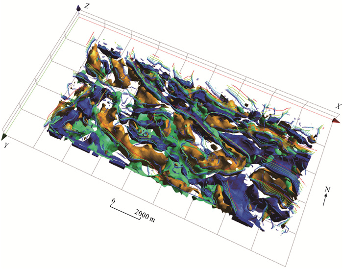
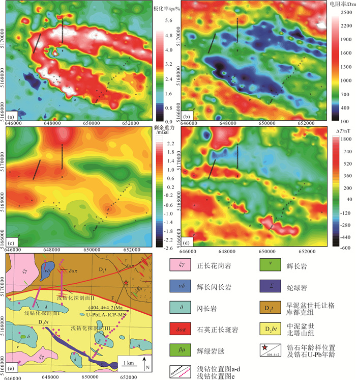
图 4 填图区域地质-地球物理初始模型
黄色不规则形体为高密度体, 蓝色为低密度体, 绿色为高磁性体; 多尺度边缘检测线由红到蓝表示其深度由深到浅
Figure 4. Initial geological-geophysical model
![]()
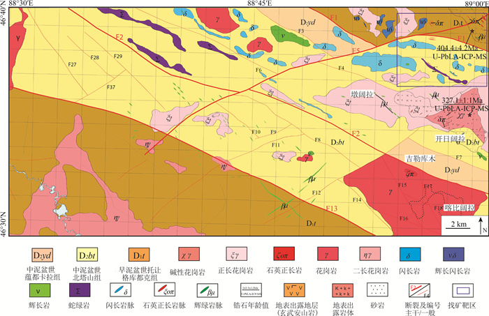
图 6 东准噶尔浅覆盖填图区基岩地质图
Figure 6. The bedrock geological map of shallow overburden area in East Junggar
-
吕庆田, 孟贵祥, 严加永, 等. 成矿系统的多尺度探测: 概念与进展——以长江中下游成矿带为例[J]. 中国地质, 2019, 46(4): 673-689. https://www.cnki.com.cn/Article/CJFDTOTAL-DIZI201904002.htm 施俊法, 唐金荣, 周平, 等. 隐伏矿勘查经验与启示——从《信息找矿战略与勘查百例》谈起[J]. 地质通报, 2008, 27(4): 433-450. doi: 10.3969/j.issn.1671-2552.2008.04.001 孟贵祥, 吕庆田, 严加永, 等. "穿透性"探测技术在覆盖区地质矿产调查中的应用研究[J]. 地球学报, 2019, 40(5): 637-650. https://www.cnki.com.cn/Article/CJFDTOTAL-DQXB201905001.htm 胡健民. 特殊地区地质填图工程概况[J]. 地质力学学报, 2016, 22(4): 803-808. doi: 10.3969/j.issn.1006-6616.2016.04.001 王国灿, 赵璇, 陈超, 等. 西北断陷盆地覆盖区填图方法探索——新疆巴里坤盆地填图实践[J]. 地质力学学报, 2016, 22(4): 809-821. doi: 10.3969/j.issn.1006-6616.2016.04.002 孟昭君, 阚学胜, 李宪臣, 等. 大兴安岭北东段森林覆盖区岔路口巨型斑岩钼多金属矿床的发现过程及意义[J]. 中国地质, 2011, 38(6): 433-450. https://www.cnki.com.cn/Article/CJFDTOTAL-DIZI201106012.htm 成秋明. 覆盖区矿产综合预测思路与方法[J]. 地球科学-中国地质大学学报, 2012, 37(6): 1109-1125. https://www.cnki.com.cn/Article/CJFDTOTAL-DQKX201206005.htm 严加永, 吕庆田, 陈向斌, 等. 基于重磁反演的三维岩性填图试验-以安徽庐枞矿集区为例[J]. 岩石学报, 2014, 30(4): 1041-1053. https://www.cnki.com.cn/Article/CJFDTOTAL-YSXB201404012.htm 汪青松. 安徽省淮北前常-徐楼覆盖区综合找矿方法研究[J]. 安徽地质, 2010, 20(3): 206-212. doi: 10.3969/j.issn.1005-6157.2010.03.011 陈超, 许顺芳, 王国灿, 等. 戈壁荒漠覆盖区地质调查中综合地球物理方法与实践[J]. 地球科学, 2021, 46(8): 3028-3038. https://www.cnki.com.cn/Article/CJFDTOTAL-DQKX202108027.htm 王东明, 田世攀, 张昱, 等. 森林-沼泽浅覆盖区地质填图方法试验——以黑龙江1: 5万望峰公社幅为例[J]. 地质通报, 2021, 40(5): 782-797. http://dzhtb.cgs.cn/gbc/ch/reader/view_abstract.aspx?file_no=20210513&flag=1 邓震, 孟贵祥, 汤贺军, 等. 浅覆盖区1: 5万基岩地质填图实践探索——以准噶尔北缘克什克涅绍喀尔(L45E009020)图幅为例[J]. 地球学报, 2019, 40(5): 651-660. https://www.cnki.com.cn/Article/CJFDTOTAL-DQXB201905002.htm 邹国庆, 余牛奔, 孙国庆, 等. 东准噶尔奥依托浪格地区石炭纪双峰式火山岩地球化学特征及其构造意义[J]. 吉林大学学报(地球科学版), 2021, 51(2): 455-472. https://www.cnki.com.cn/Article/CJFDTOTAL-CCDZ202102012.htm 聂凤军, 江思宏. 中蒙边境塔林大型金矿化带的发现对我们的启示[J]. 内蒙古地质, 2000, 95(2): 20-23. https://www.cnki.com.cn/Article/CJFDTOTAL-NMGZ200002002.htm 李光明, 秦克章, 李金祥. 哈萨克斯坦环巴尔喀什斑岩铜矿地质与成矿背景研究[J]. 岩石学报, 2008, 24(12): 2679-2700. https://www.cnki.com.cn/Article/CJFDTOTAL-YSXB200812004.htm 王登红, 李华芹, 应立娟, 等. 新疆伊吾琼河坝地区铜、金矿成矿时代及其找矿前景[J]. 矿床地质, 2009, 28(1): 73-82. doi: 10.3969/j.issn.0258-7106.2009.01.007 董连慧, 徐兴旺, 屈迅, 等. 初论环准噶尔斑岩铜矿带的地质构造背景与形成机制[J]. 岩石学报, 2009, 25(4): 713-737. https://www.cnki.com.cn/Article/CJFDTOTAL-YSXB200904001.htm 李锦轶. 新疆东准噶尔蛇绿岩的基本特征和侵位历史[J]. 岩石学报, 1995, 11(增): 73-84. https://www.cnki.com.cn/Article/CJFDTOTAL-YSXB5S1.005.htm 李锦轶, 何国琦, 徐新, 等. 新疆北部及邻区地壳构造格架及其形成过程的初步探讨[J]. 地质学报, 2006, 80(1): 148-168. doi: 10.3321/j.issn:0001-5717.2006.01.017 王宗秀, 周高志, 李涛. 对新疆北部蛇绿岩及相关问题的思考和认识[J]. 岩石学报, 2003, 19(4): 683-691. https://www.cnki.com.cn/Article/CJFDTOTAL-YSXB200304008.htm 张连昌, 夏斌, 牛贺才, 等. 新疆晚古生代大陆边缘成矿系统与成矿区带初步探讨[J]. 岩石学报, 2006, 22(5): 1387-1398. https://www.cnki.com.cn/Article/CJFDTOTAL-YSXB200605028.htm 王玉往, 王京彬, 龙灵利, 等. 岩浆混合作用的类型、标志、机制、模式及其与成矿的关系——以新疆北部为例[J]. 岩石学报, 2012, 28(8): 2317-2330. https://www.cnki.com.cn/Article/CJFDTOTAL-YSXB201208003.htm 王京彬, 徐新. 新疆北部后碰撞构造演化与成矿[J]. 地质学报, 2006, 80(1): 23-31. https://www.cnki.com.cn/Article/CJFDTOTAL-DZXE200601002.htm 刘国仁, 秦纪华, 张立武, 等. 新疆玉勒肯哈腊苏铜矿床深部及外围找矿方向[J]. 矿床地质, 2012, 31(增刊): 861-862. https://www.cnki.com.cn/Article/CJFDTOTAL-KCDZ2012S1435.htm 肖文交, Windley B F, 阎全人, 等. 北疆地区阿尔曼太蛇绿岩锆石SHRIMP年龄及其大地构造意义[J]. 地质学报, 2006, 80(1): 32-37. doi: 10.3321/j.issn:0001-5717.2006.01.004 新疆地质调查院. 新疆富蕴县L45E009019、L45E009020、L45E010019、L45E010020四幅区域地质矿产调查报告. 2017. 中国地质调查局西安地质调查中心. 阿勒泰-准噶尔北缘成矿带基础地质综合研究报告. 2017. 新疆地质矿产勘查开发局. 新疆维吾尔自治区矿产资源潜力评价成果报告. 2017.

 下载:
下载:


计量
- 文章访问数: 2303
- HTML全文浏览量: 344
- PDF下载量: 1685
