
Geological hazard susceptibility evaluation based on improved information model: A case study of the G219 National Highway in Zayu County, Xizang
-
摘要:研究目的
公路建设引起道路沿线地质灾害频发。道路沿线地质灾害易发性评价是地质灾害应急救援中的关键问题,其评价结果可为灾害防范和应急决策提供科学依据,有助于减少灾害带来的潜在损失。
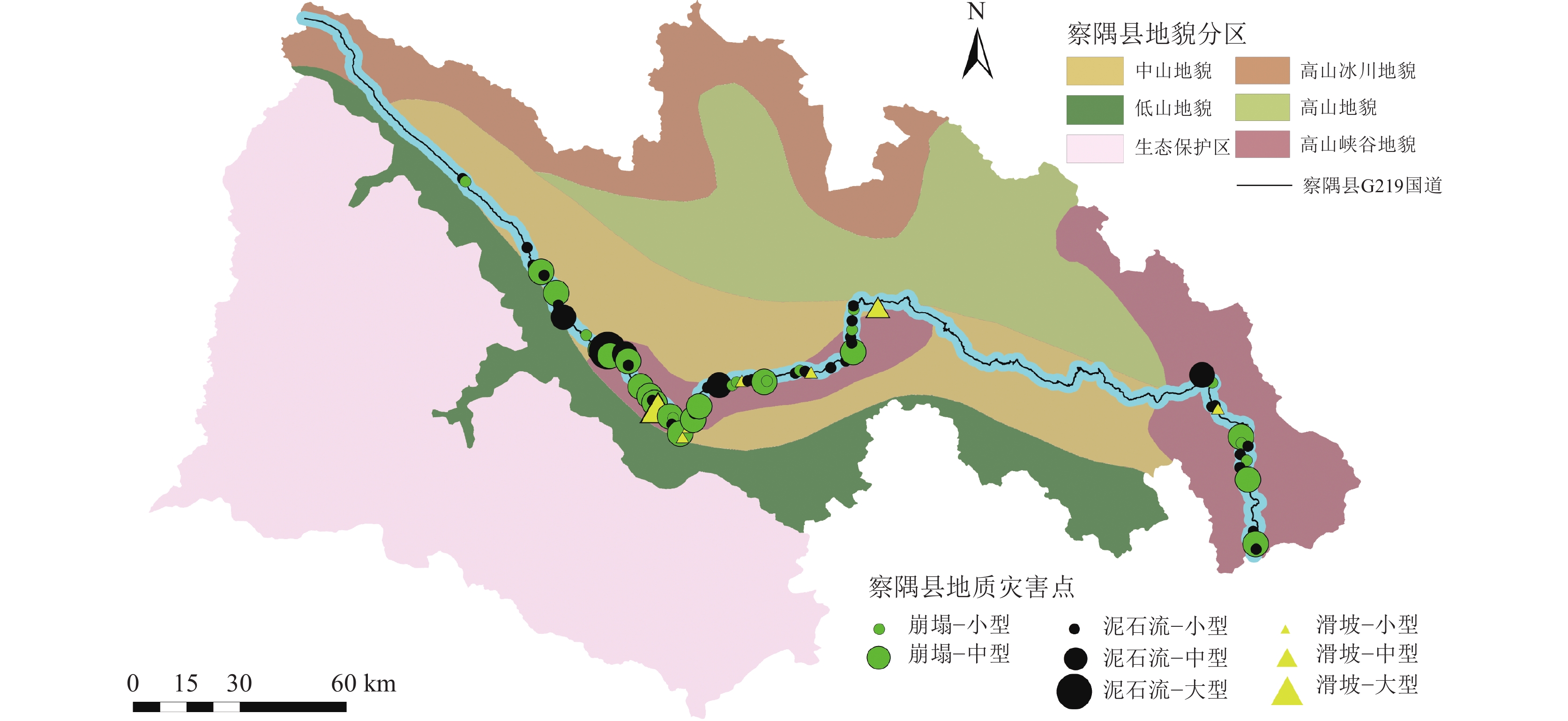
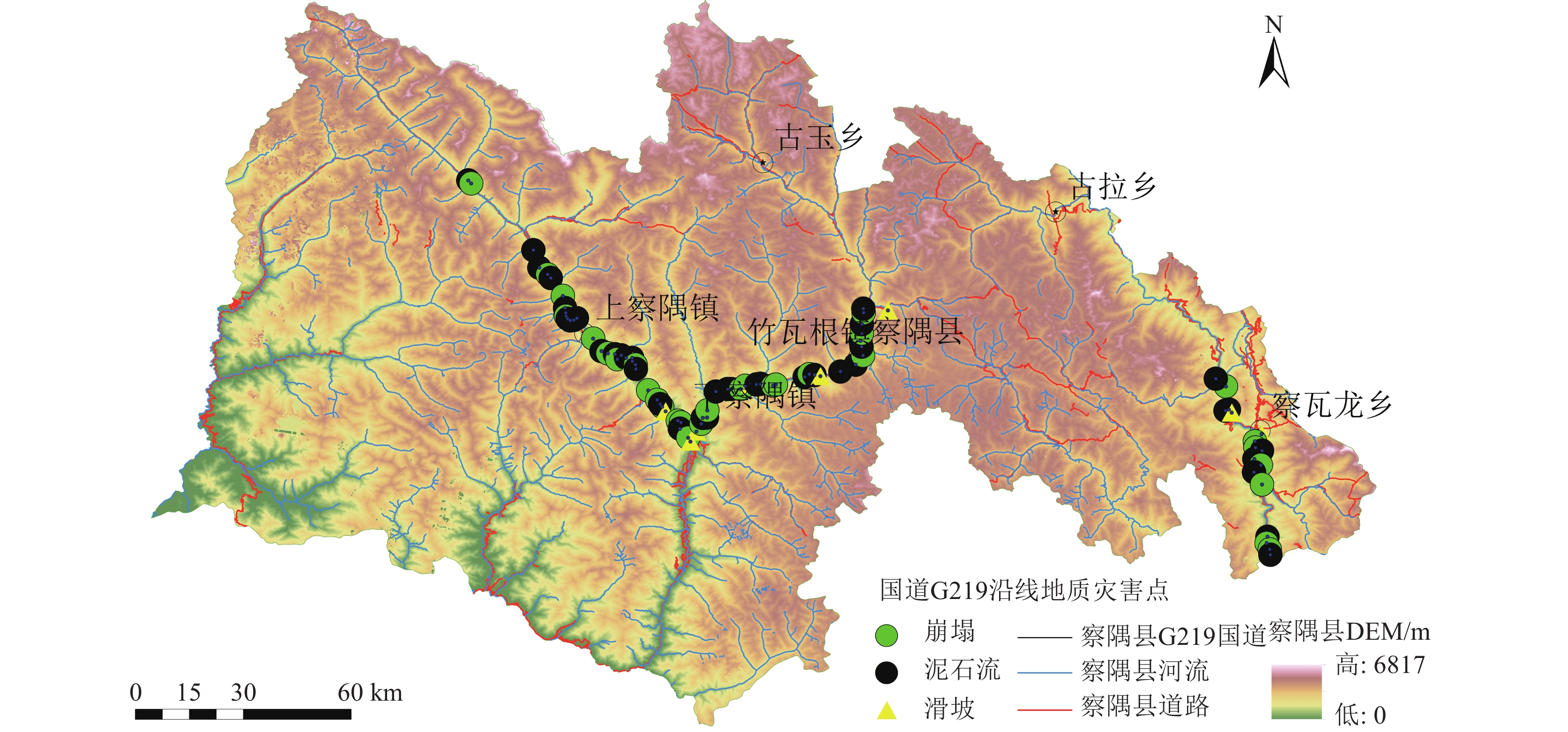
研究方法察隅县G219国道沿线共发育地质灾害85处(其中滑坡9处、崩塌31处、泥石流45处)。根据地质灾害的发育特征,选取水系线密度、道路线密度、地震峰值加速度、地震反应谱特征、岩组、地貌、DEM、平面曲率、剖面曲率、坡向和坡度11个影响因素作为评价因子,将地质灾害点核密度分析与信息量法相结合,改进信息量法模型,并运用GIS技术对研究区域的地质灾害易发性进行评价。
研究结果研究表明,基于改进的信息量法模型的易发性评价结果与实际灾害分布情况高度吻合。模型评价精度较高,AUC值达到0.836,表明模型对地质灾害易发性的预测能力显著。
结论改进的信息量法模型在评价地质灾害易发性方面表现出更优的精度,可为察隅县及其附近区域的城镇规划建设和地质灾害风险管理提供可靠的科学依据。
Abstract:ObjectiveDue to the impact of highway construction, geological hazards along roadways occur frequently. The susceptibility evaluation of geological hazards along roadways is a key issue in emergency response and rescue. The evaluation results can provide a scientific basis for disaster prevention and emergency decision-making, helping to mitigate potential losses caused by such hazards.
MethodsAlong the G219 Highway in Zayu County, 85 geological disaster sites were identified (including 9 landslides, 31 collapses, and 45 debris flows). Based on the developmental characteristics of geological disasters, 11 influencing factors were selected as evaluation indicators: drainage density, road density, peak ground acceleration, seismic response spectrum characteristics, rock groups, geomorphology, DEM, plan curvature, profile curvature, aspect, and slope. A modified information value model combining geological disaster kernel density analysis with the information value method was developed. GIS technology was applied to evaluate the susceptibility of geological disasters in the study area.
ResultsThe results show that the susceptibility evaluation based on the modified information value model aligns closely with the actual distribution of geological disasters. The model demonstrated high predictive accuracy, with an AUC value of 0.836, indicating its significant capability in assessing geological disaster susceptibility.
ConclusionsThe modified information value model provides superior evaluation accuracy and offers reliable scientific support for urban planning, construction, and geological disaster risk management in Zayu County and surrounding areas.
创新点核密度分析与信息量法结合用于察隅县G219国道沿线地质灾害易发性评价。
-
-
![]()
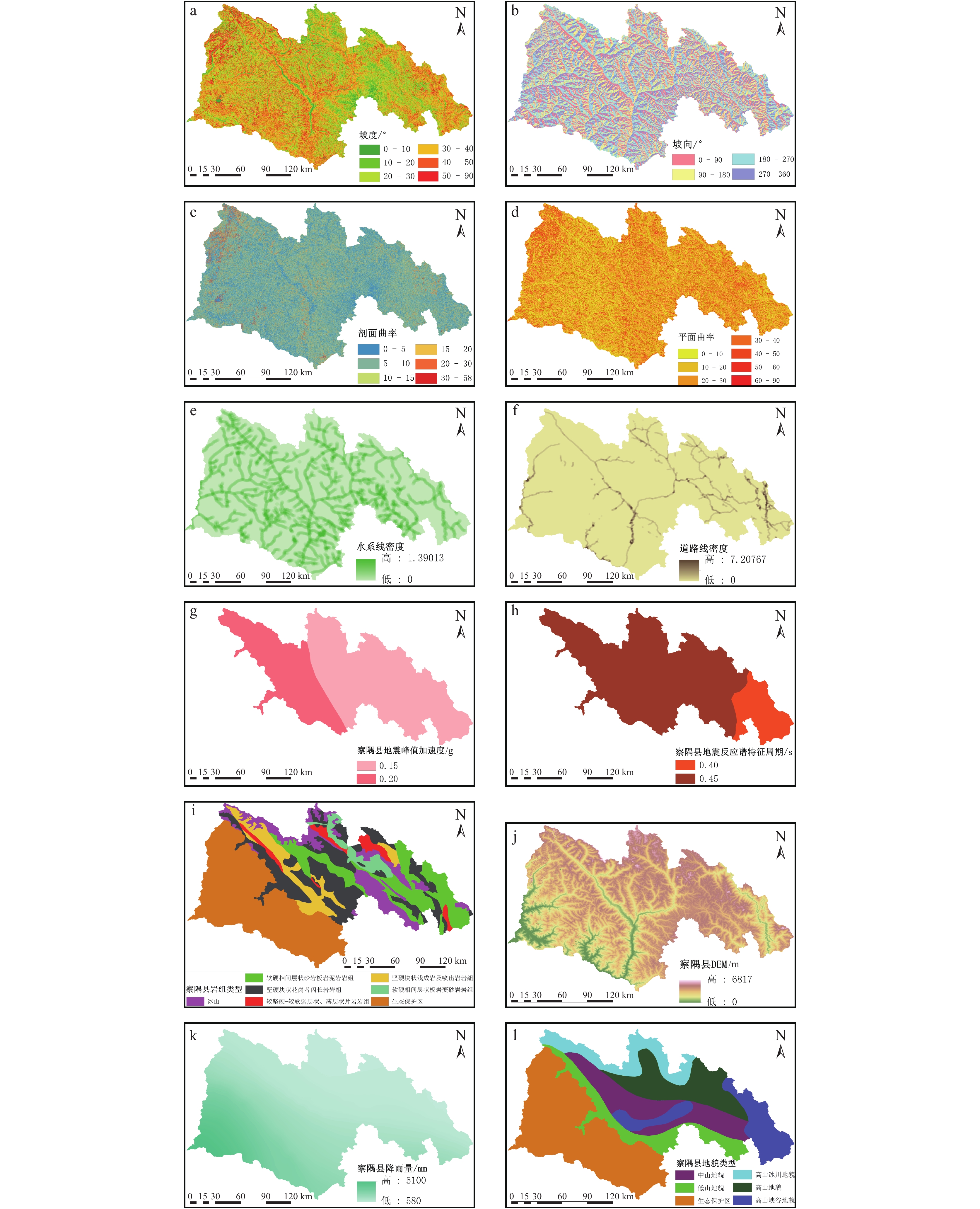
图 3 评价因子分布图
a—坡度;b—坡向;c—剖面曲率;d—平面曲率;e—水系线密度;f—道路线密度;g—地震峰值加速度;h—地震反应谱特征;i—岩组;j—DEM;k—降雨量;l—地貌
Figure 3. Evaluation factor
![]()
图 4 基于改进信息量模型的地质灾害易发性评价框架流程图
Figure 4. Flow chart of geological hazard susceptibility assessment framework based on improved information model
![]()
图 5 基于信息量法地质灾害易发性分区图
Figure 5. Geological hazard susceptibility zoning map based on information method
![]()
图 6 基于信息量法地质灾害易发性评价
Figure 6. Geological hazard susceptibility evaluation based on information method
![]()
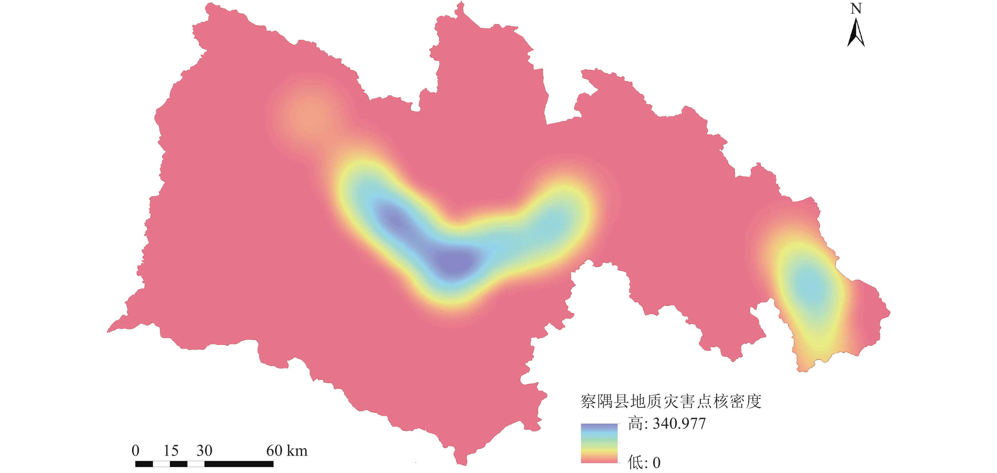
图 7 察隅县地质灾害点核密度估计
Figure 7. Nuclear density estimation of geological disaster sites in Zayu County
![]()
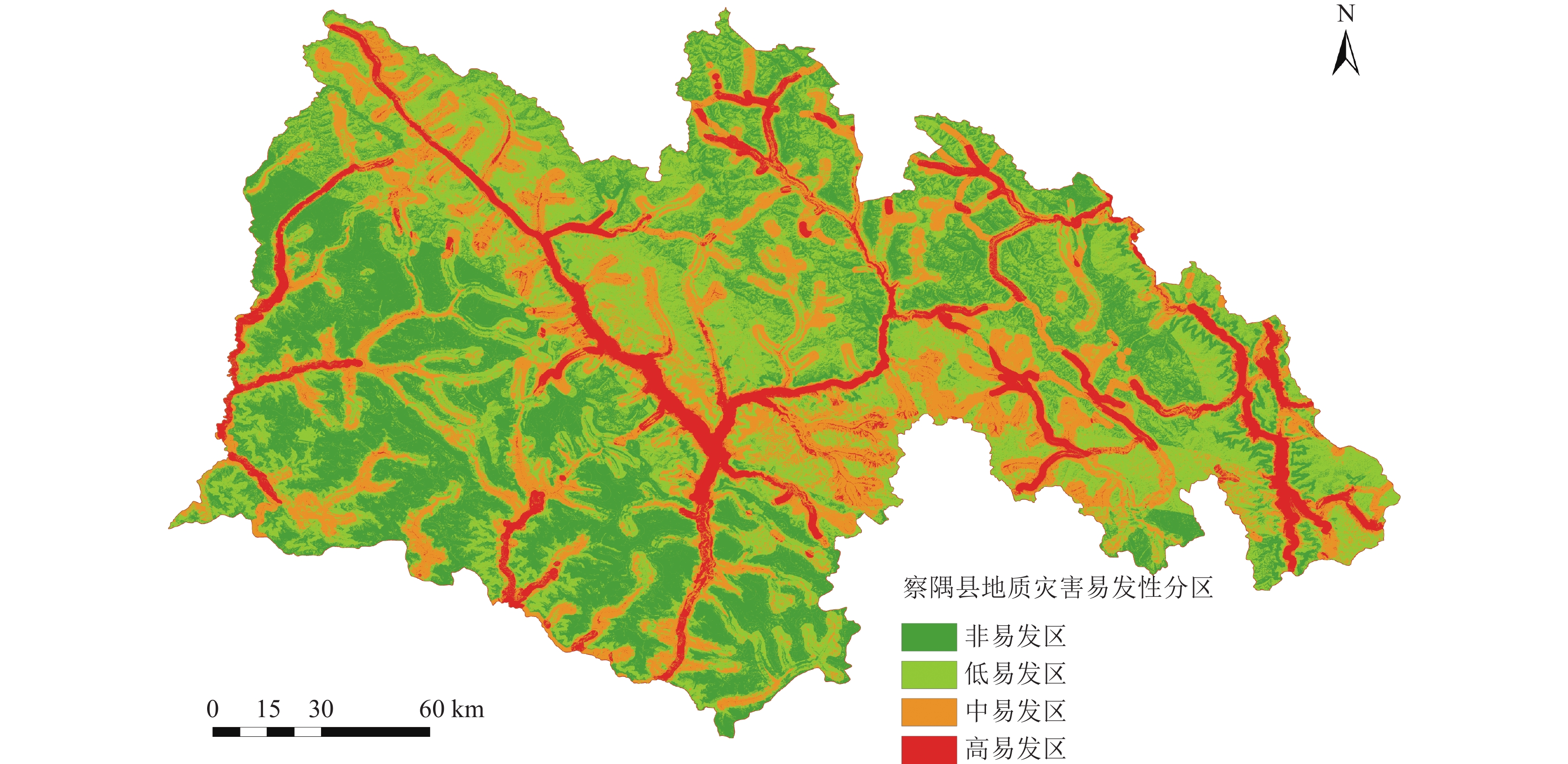
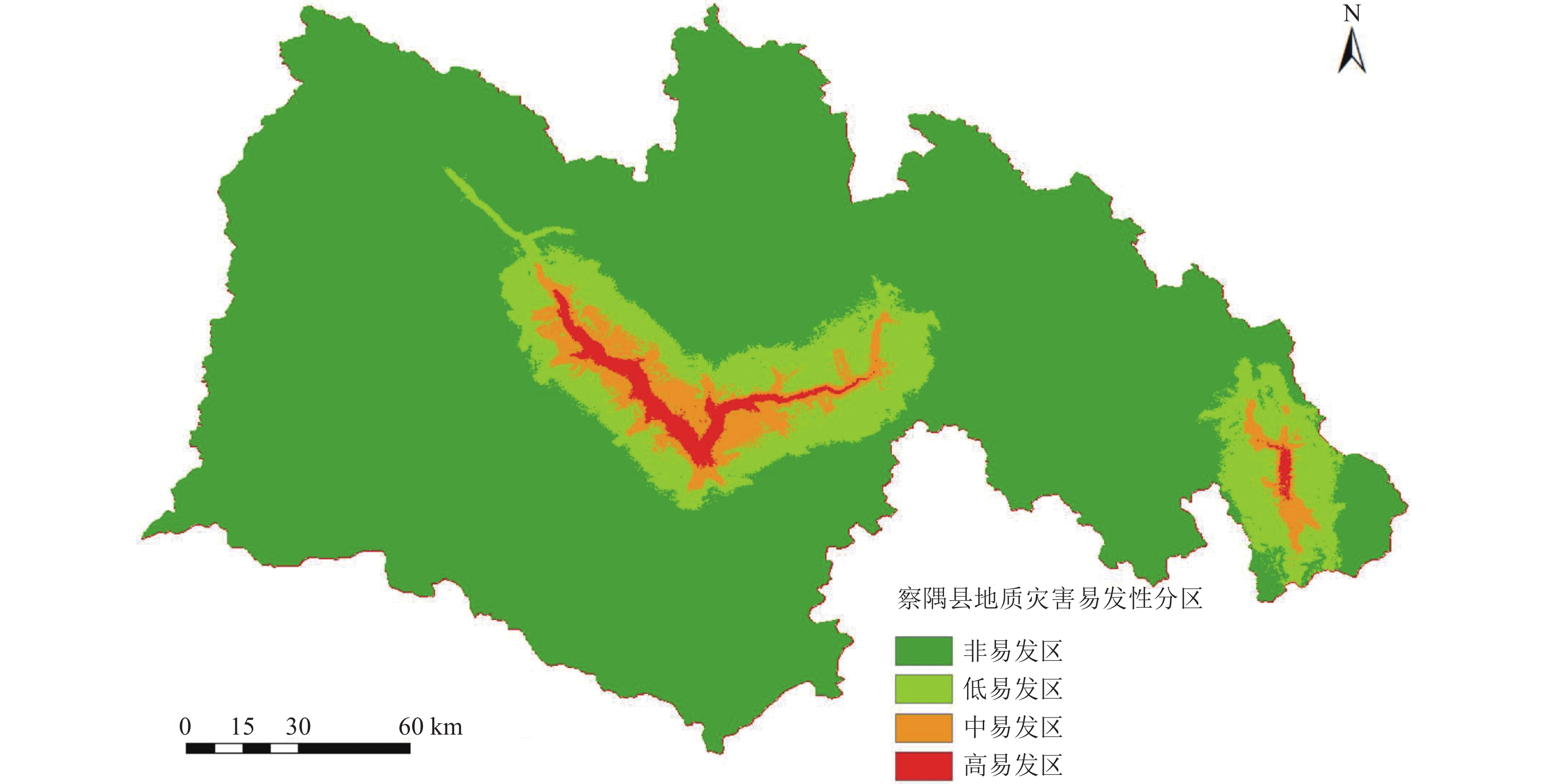
图 8 基于改进信息量法的地质灾害易发性分区图
Figure 8. Geological hazard susceptibility zoning map based on improved information method
![]()
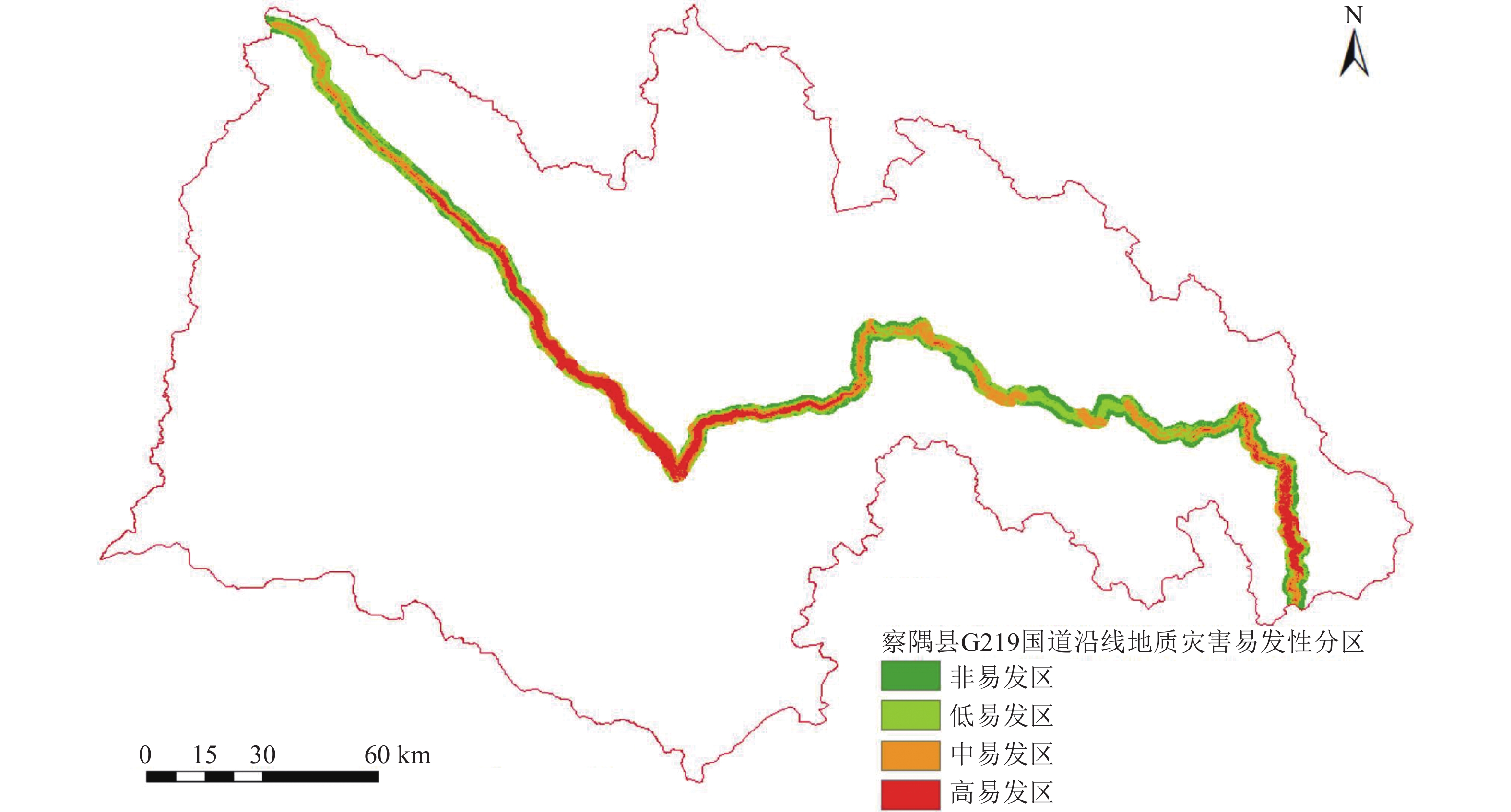
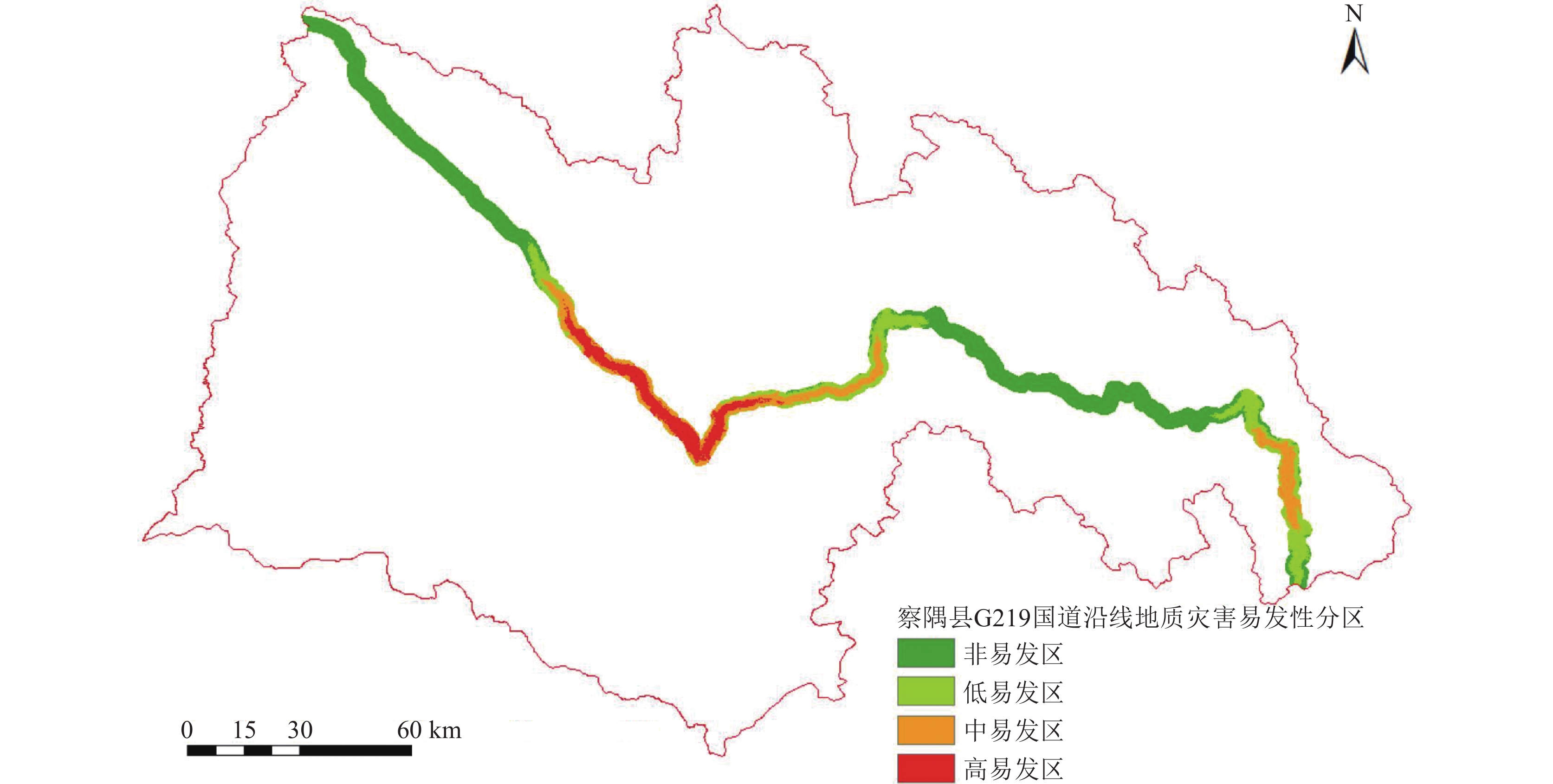
图 9 基于改进信息量法的察隅县G219国道沿线地质灾害易发性分区图
Figure 9. Geological hazard susceptibility zoning map along G219 National Highway in Zayu County based on improved information method
![]()
图 11 信息量法和改进信息量法ROC曲线
Figure 11. ROC curves of information method and improved information method
表 1 察隅县G219国道沿线地质灾害规模等级
Table 1 Geological disaster scale level along the G219 National Highway in Zayu County
处 灾害类型 大型 中型 小型 合计 滑坡 0 2 7 9 崩塌 0 18 13 31 泥石流 1 8 36 45 合计 1 28 56 85  下载: 导出CSV
表 2 察隅县G219国道沿线地质灾害现状稳定性与发展趋势
Table 2 The stability and development trend of geological disasters along the National Highway G219 in Zayu County
处 状态 稳定性 滑坡 崩塌 泥石流 合计 现状稳定性 不稳定 1 26 \ 27 较稳定 3 5 7 15 稳定 5 \ 38 43 发展趋势 不稳定 1 27 \ 28 较稳定 8 4 18 30 稳定 \ \ 27 27
下载: 导出CSV
表 3 相关性分析矩阵
Table 3 Correlation analysis matrix
因子 a b c d e f g h i j k l a 1 0.2790 0.0150 0.0800 0.0345 −0.0002 −0.0081 −0.326 −0.0310 −0.0175 −0.0001 0.0346 b 0.2790 1 −0.0507 −0.1151 −0.0413 −0.1001 −0.0538 −0.2844 −0.0126 −0.0301 −0.0088 −0.0586 c 0.0150 −0.0507 1 0.2991 0.0531 0.1175 0.1022 −0.1320 −0.0276 0.0321 0.0079 0.0862 d 0.0800 −0.1151 0.2991 1 0.0746 0.2185 −0.0210 0.1465 0.0019 −0.0131 −0.0146 −0.0684 e 0.0345 −0.0413 0.0531 0.0746 1 0.2798 0.6667 −0.4106 −0.0264 0.0331 0.0395 0.1196 f −0.0002 −0.1001 0.1175 0.2185 0.2798 1 0.2403 0.0445 −0.0051 0.0109 −0.0042 0.0090 g −0.0081 −0.0538 0.1022 −0.0210 0.6667 0.2403 1 −0.6120 −0.0342 0.0044 0.0269 0.1160 h −0.3266 −0.2844 −0.1320 0.1465 −0.4106 0.0445 −0.6120 1 0.0534 0.0100 −0.0184 −0.1416 i −0.0310 −0.0126 −0.0276 0.0019 −0.0264 −0.0051 −0.0342 0.0534 1 0.2679 −0.0206 −0.2962 j −0.0175 −0.0301 0.0321 −0.0131 0.0331 0.0109 0.0044 0.0100 0.26790 1 −0.0344 0.1158 k −0.0001 −0.0088 0.0079 −0.0146 0.0395 −0.0042 0.0269 −0.0184 −0.0206 −0.0344 1 0.0289 l 0.0346 −0.0586 0.0862 −0.0684 0.1196 0.0090 0.1160 −0.1416 −0.2962 0.1158 0.0289 1 注:a—水系线密度;b—道路线密度; c—地震峰值加速度;d—地震反应谱特征; e—岩组;f—地貌; g—降雨量; h—DEM; i—平面曲率; j—剖面曲率; k—坡向; l—坡度
下载: 导出CSV
表 4 主成分分析结果
Table 4 Results of principal component analysis
因子 特征值 特征值占比 特征值累计占比 水系线密度 439.846 46.38% 46.38% 道路线密度 367.880 38.79% 85.18% 坡度 75.437 7.96% 93.13% 岩组 18.325 1.93% 95.07% 地震峰值加速度 14.236 1.50% 96.57% 地貌 13.091 1.38% 97.95% DEM 10.895 1.15% 99.10% 平面曲率 6.383 0.67% 99.77% 剖面曲率 1.323 0.14% 99.91% 坡向 0.606 0.06% 99.97% 地震反应谱特征 0.250 0.03% 100.00%
下载: 导出CSV
表 5 评价因子各分区区间信息量
Table 5 Information value of each zone of evaluation factor
因子 分区区间 信息量 DEM 0~1600 0.3102 1600~2300 2.3956 2300~2900 0.5967 2900~3500 −2.4469 3500~6900 0 剖面曲率 0~5 0.2742 5~10 −0.1723 10~15 −0.2335 15~20 0.0451 20~30 −0.94 30~58 0 地貌 中山地貌 0.7517 低山地貌 1.7254 其他 0 地震反应谱特征周期 0.4 0.4844 0.45 0.4842 地震峰值加速度 0.15 0.0297 0.20 1.0226 坡向 0~90 0.5252 90~180 −0.5728 180~270 −0.3118 270~360 0.032 坡度 0~10 1.3547 10~20 0.6354 20~30 −0.123 30~40 −0.8226 40~50 −0.4084 50~90 −0.6364 工程地质岩组 坚硬块状花岗者闪长岩岩组 0.563 软硬相间层状砂岩板岩泥岩岩组 0.0301 冰山 0.3581 较坚硬-较软弱层状、薄层状片岩岩组 1.2453 其他 0 平面曲率 0~10 −0.0391 10~20 −0.0279 20~30 −0.3062 30~40 −0.5248 40~50 0.1163 50~60 0.4755 60~90 0.5718 水系线密度 0~0.08 −3.7177 0.08~0.24 −2.4331 0.24~0.42 0.6696 0.42~0.62 1.6218 0.62~1.4 0.7205 道路线密度 0~0.28 −2.8886 0.28~0.87 1.8923 0.87~1.64 2.4519 1.64~2.85 2.1497 2.85~7.3 2.8018
下载: 导出CSV
表 6 基于信息量法的分区占比
Table 6 Partition ratio based on information method
易发分区 信息量范围 面积占比 灾害点数量/个 高易发区 2.1280~15.3661 9.19% 83 中易发区 −2.6555~2.1280 24.45% 2 低易发区 −5.9929~−2.6555 37.84% 0 非易发区 −13.0013~−5.9929 29.52% 0
下载: 导出CSV
表 7 基于信息量法的分区占比(国道G219沿线)
Table 7 Partition ratio based on information method (along National Highway G219)
易发分区 信息量范围 面积占比 灾害点数量/个 高易发区 7.3162~15.3661 20.32% 63 中易发区 −2.6555~7.3162 30.52% 20 低易发区 −5.9929~−2.6555 28.87% 2 非易发区 −10.2920~−5.9929 20.29% 0
下载: 导出CSV
表 8 基于改进信息量法的分区占比
Table 8 Partition ratio based on improved information method
易发分区 改进信息量范围 面积占比 灾害点数量/个 高易发区 160.8139~320.371 1.15% 55 中易发区 75.3815~160.8139 3.65% 23 低易发区 22.6144~75.3815 10.25% 7 非易发区 0~22.6144 84.95% 0
下载: 导出CSV
表 9 基于改进信息量法的分区占比(国道G219沿线)
Table 9 Partition ratio based on improved information method (along National Highway G219)
易发分区 改进信息量范围 面积占比 灾害点数量/个 高易发区 201.0584~320.371 11.56% 36 中易发区 115.6555~201.0584 19.20% 36 低易发区 41.5559~115.6555 20.59% 11 非易发区 0.11~−41.5559 48.65% 2
下载: 导出CSV
-
Chen J G, Zhong L X. 2023. Assessment of rockfall susceptibility along the expressway based on the CF−AHP coupling model: A case study of the Tucheng−Wanglong section of the Rongzun expressway[J]. The Chinese Journal of Geological Hazard and Control, 34(6): 105−115 (in Chinese with English abstract).
Dias H C, Hölbling D, Grohmann C H, 2021. Landslide susceptibility mapping in Brazil: A review[J]. Geosciences, 11(10): 425.
Feng W, Tang Y M, Ma H N. 2021. Comprehensive risk assessment of multi−hazard natural disastersin Xianyang City based on AHP[J]. Northwestern Geology, 54(2): 282−288(in Chinese with English abstract).
Fleuchaus P, Blum P, Wilde M, et al. 2021. Retrospective evaluation of landslide susceptibility maps and review of validation practice[J]. Environmental Earth Sciences, 80: 1−15. doi: 10.1007/s12665-020-09327-2
Hao Q, Wei K, Zhao Z W, et al. 2023. Evaluation of geological hazard susceptibility of debris flow based on slope unit: A case study of Xintai City, Shandong Province[J]. Huabei Natural Resources, (2): 106−111(in Chinese with English abstract).
Hou R N, Li Z, Chen N S, et al. 2023. Modeling of debris flow susceptibility assessmentl in Tianshan based on watershed unit and stacking ensemble algorithm[J]. Earth Science, 48(5): 1892−1907 (in Chinese with English abstract).
Huang X P, Zheng L, Du J, et al. 2023. Regional rockfall hazard susceptibility assessment considering combination modes of rock mass dis−l continuities[J]. Safety and Environmental Engineering, 30(1): 163−172(in Chinese with English abstract).
Kang Y H, Wang Y Y, Xia Z J, et al. 2018. Identification and classification of Wuhan urban districts based on POI[J]. Journal of Gcomatics, (1): 81−85 (in Chinese with English abstract).
Lan Z X, Zheng B, Liao D W, et al. 2023. Risk assessment of geological disasters in Dayu town, Sandu county, Guizhou province based on information quantity method and slope unit[J]. Ground Water, 45(5): 160−163 (in Chinese with English abstract).
Li S, Shang Y J, Wei, S Y, et al. 2020. Study on the susceptibility and causes of geohazards of Karakoram highway[J]. Xinjiang Geology, 38(4): 532−538(in Chinese with English abstract).
Meng X R, Pei X J, Liu Q H, et al. 2016. GIS−Based susceptibility assessment of geological hazards along the road from Dujiangyan to Wenchuan by factor analysis[J]. The Chinese Journal of Geological Hazard and Control, 27(3): 106−115(in Chinese with English abstract).
Sun B, Zhu C B, Kang X B, et al. 2022. Susceptibility assessment of debris flows based on information model in Dongchuan, Yunnan Province[J]. The Chinese Journal of Geological Hazard and Control, 33(5): 119−127(in Chinese with English abstract).
Wei Y, 2020. Geological Disaster Susceptibility assessment along expressway in Southwest Mountain area: A case study of Panzhihua−Yanyuan expressway[D]. Master’s Thesis of Chengdu University of Technology (in Chinese with English abstract).
Wu X, Song Y, Chen W, et al. 2023. Analysis of geological hazard susceptibility of landslides in Muli County based on random forest algorithm[J]. Sustainability, 15(5): 4328. doi: 10.3390/su15054328
Xu Z H, 2020. Susceptibility Evaluation of geological hazards in Zhen'an section of 345 national highway[D]. Master’s Thesis of Xi 'an University of Science and Technology (in Chinese with English abstract).
Yang R, Yu C Y, Wang Y, 2023. Susceptibility evaluation of geological disaster based on weighted information and GIS method: A case study of Yushe County[J]. Mining Research and Development, 43(2): 163−170(in Chinese with English abstract).
Zeng B, Yang M Y, Shao C J, et al. 2018. Susceptibility assessment of karst collapse of Hangchang Expressway Projects based on analytic hierarchy process[J]. Safety and Environmental Engineering, 25(1): 29−38 (in Chinese with English abstract).
Zhang T. 2015. Research on risk evoluation of geological disasters in Tianshan Highway in Xinjiang[D]. Master’s Thesis of Chongqing Jiaotong Univerisity (in Chinese with English abstract).
Zhou Y, Wang Y S, Zhao X, et al. 2022. Susceptibility assessment of debris flow in Dimaluo River, branch of Nujiang River[J]. Geological Bulletin of China, 41(4): 702−712 (in Chinese with English abstract).
Zhu M L, Tang X L, Yang W L, et al. 2023. Application of optimised SVM model to mudslide susceptibility[J]. Foreign Electronic Measurement Technology, 42(6): 163−170 (in Chinese with English abstract).
陈建国, 钟连祥. 2023. 基于CF-AHP耦合模型的高速公路沿线崩塌地质灾害易发性评价——以蓉遵高速公路土城−旺隆段为例[J]. 中国地质灾害与防治学报, 34(6): 105−115. 冯卫, 唐亚明, 马红娜, 等. 2021. 基于层次分析法的咸阳市多灾种自然灾害综合风险评价[J]. 西北地质, 54(2): 282−288. 郝骐, 魏凯, 赵志伟, 等. 2023. 基于斜坡单元的泥石流地质灾害易发性评价——以山东新泰市为例[J]. 华北自然资源, (2): 106−111. 侯儒宁, 李志, 陈宁生, 等. 2023. 基于流域单元和堆叠集成模型的天山地区泥石流易发性评估建模[J]. 地球科学, 48(5): 1892−1907. 黄肖萍, 郑莉, 杜娟, 等. 2023. 考虑岩体结构面组合的区域崩塌灾害易发性评价[J]. 安全与环境工程, 30(1): 163−172. 康雨豪, 王玥瑶, 夏竹君, 等. 2018. 利用POI数据的武汉城市功能区划分与识别[J]. 测绘地理信息, (1): 81−85. 兰中孝, 郑冰, 廖德武, 等. 2023. 基于信息量法与斜坡单元的贵州省三都县打鱼镇地质灾害风险评价[J]. 地下水, 45(5): 160−163. 李坤, 尚彦军, 魏思宇, 等. 2020. 喀喇昆仑公路国内段地质灾害易发性评价及成因分析[J]. 新疆地质, 38(4): 532−538. doi: 10.3969/j.issn.1000-8845.2020.04.018 孟祥瑞, 裴向军, 刘清华, 等. 2016. GIS支持下基于因子分析法的都汶路沿线地质灾害易发性评价[J]. 中国地质灾害与防治学报, 27(3): 106−115. 孙滨, 祝传兵, 康晓波, 等. 2022. 基于信息量模型的云南东川泥石流易发性评价[J]. 中国地质灾害与防治学报, 33(5): 119−127. 魏雨. 2020. 西南山区高速公路沿线地质灾害易发性评价——以攀枝花至盐源高速为例[D]. 成都理工大学硕士学位论文. 徐志浩. 2020.345国道镇安段公路地质灾害易发性评价[D]. 西安科技大学硕士学位论文. 杨锐, 于春勇, 汪洋. 2023. 基于加权信息量和GIS方法的地质灾害易发性评价——以榆社县为例[J]. 矿业研究与开发, 43(2): 163−170. 曾斌, 杨木易, 邵长杰, 等. 2018. 基于层次分析法的杭长高速岩溶塌陷易发性评价[J]. 安全与环境工程, 25(1): 29−38. 张婷. 2015. 新疆天山公路地质灾害危险性评价研究[D]. 重庆交通大学硕士学位论文. 周粤, 王运生, 赵逊, 等. 2022. 怒江支流迪麻洛河流域泥石流易发性评价[J]. 地质通报, 41(4): 702−712. 朱木雷, 谭晓玲, 杨伟良, 等. 2023. 优化SVM模型在泥石流易发性中的应用[J]. 国外电子测量技术, 42(6): 163−170.


计量
- 文章访问数: 1169
- HTML全文浏览量: 228
- PDF下载量: 217
