Mapping test of lithological association-lithofacies in continental volcanic rock field:A case study of western Taipusi caldera, in Inner Mongolia
-
摘要:
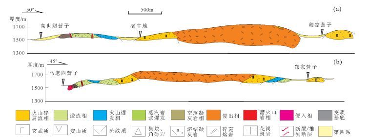
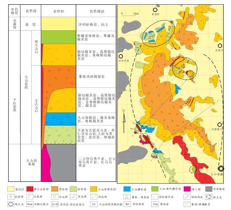
中国陆相火山岩区的填图方法半个多世纪以来几经反复,为了与传统的沉积岩区填图方法相区别,反映火山作用的特点,先后探索过双重填图法(即岩相-地层学填图方法)、火山构造-岩性岩相-火山地层填图法等,在局部地区取得过重要进展和成果。但在全国层面的实际填图工作中,没有摆脱将火山岩作为地层(组)的习惯性做法。探索和总结适合陆相火山岩区的填图方法体系,坚持推广反映火山作用特点的填图技术方法仍然是区调工作面临的重大问题。火山岩相是重溯火山作用过程、恢复古火山机构的基础,理应成为火山岩地质图所要表达的核心要素,而岩性组合是确定岩相类型最直接和最可靠的依据。利用岩性组合-岩相进行火山岩区填图能够很好地反映陆相火山作用的特点。
Abstract:The mapping method for continental volcanic rock field with the purpose of reflecting the volcanic characteristics is different from the traditional method suitable for sedimentary area, and this problem has been groped for over half a century in China. The "diplex mapping method"(lithofacies+stratigraphy) and the "volcanic construction-lithologic rock facies-volcanic sequence" have been explored, with important progress and achievement obtained in local area. Nevertheless, the fact that volcanic rock was mapped as stratum (formation) did not get out of habitual practice in actual mapping at the national level. It is still a significant task to explore and summarize mapping method suitable for continental volcanic rocks. Volcanic facies is a foundation for restoration of the processes of volcanism and ancient volcanic apparatus, and should be shown as key elements in volcanic geological maps, whereas lithological association is a most reliable basis for assigning types of lithofacies. The continental volcanic characteristics can be well reflected on the basis of lithological association-lithofacies mapping.
-
Keywords:
- lithological association /
- lithofacies /
- volcanic mapping /
- caldera /
- Taipusiqi
-
致谢: 中国地质科学院地质研究所王涛研究员在成文和图面表达方面提出了很好的建议,在此深表感谢。
-
-
区域地质矿产地质司.火山岩地区区域地质调查方法指南[M].北京:地质出版社, 1987:1-305. 陶奎元.火山岩相构造学[M].南京:江苏科学技术出版社, 1994. 傅树超, 卢清地.陆相火山岩区填图方法研究新进展——"火山构造-火山岩相-火山地层"填图方法[J].地质通报, 2010, 29(11):1640-1648. http://dzhtb.cgs.cn/ch/reader/view_abstract.aspx?flag=1&file_no=20101106&journal_id=gbc Steven T A, Lipman P W. Calderas of the San Juan volcanic field, southwestern Colorado[J]. U.S. Geol. Surv., Prof. Pap., 1976, 958:1-35. https://pubs.usgs.gov/pp/0958/report.pdf
Lipman P W, Steven T A, Mehnert H H. Volcanic history of the San Juan Mountains, Colorado, as indicated by potassium-argon dating[J]. GSA Bull., 1970, 81:2329-2352. doi: 10.1130/0016-7606(1970)81[2329:VHOTSJ]2.0.CO;2
Lipman P W. Oligocene-Miocene San Juan volcanic field, Colorado[C]//Chapin C E, Zidek J. Field Excursion to Volcanic Terranes in the Western United States, Volume 1:Southern Rocky Mountain Region. N.M. Bur. Mines Miner. Resour. Mem., 1989, 46:303-305.
Lake E T, Farmer G L. Oligo-Miocene mafic intrusions of the San Juan volcanic field, southwestern Colorado, and their relationship to voluminous, caldera-forming magmas[J]. Geochimica et Cosmochimica Acta, 2015, 157:86-108. doi: 10.1016/j.gca.2015.02.020
顿斯基赫B B, 泽列普根B H, 克罗尼道夫ИИ[著]. 林彻, 何庆先, 徐成彦[译]. 古火山地质测量方法[M]. 北京: 地质出版社, 1984: 1-258. 陶奎元, 黄光昭, 王美星, 等.中国东南部碎斑熔岩基本特征及成因机理的探讨[J].中国地质科学院南京地质矿产研究所所刊, 1985, 6(1):1-21. http://cpfd.cnki.com.cn/Article/CPFDTOTAL-ZGDJ198501001003.htm


 下载:
下载:


