Development characteristics of unloading zones of high and steep bank slope in the Yiong Tsangpo of Tibet and its engineering significance
-
摘要:
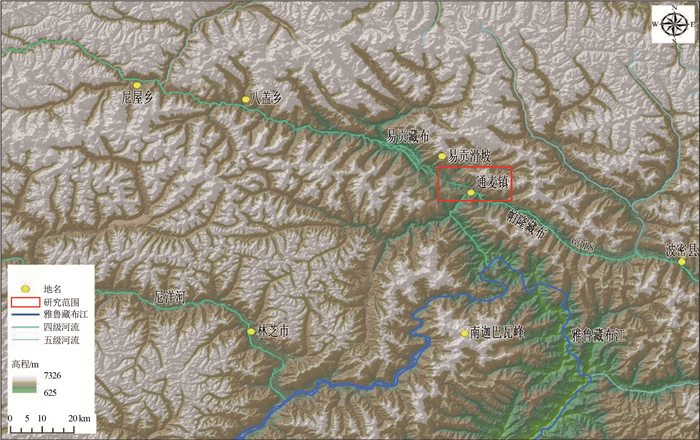
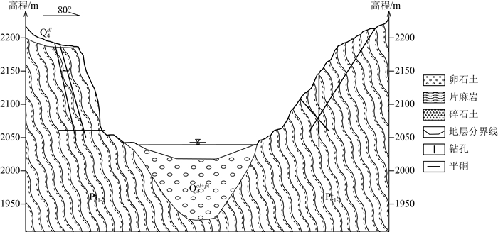
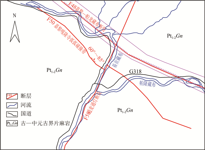
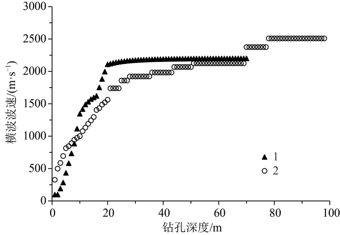
易贡藏布流域位于青藏高原喜马拉雅东构造结顶端区域,呈现高山峡谷地貌特征,地质构造复杂,地质灾害和高陡斜坡失稳现象极发育。为确定易贡藏布流域地质灾害形成机制和边坡失稳模式,通过开展边坡结构面调查、定向斜孔钻探、孔内波速测试、平硐勘探及地震波法,分析了易贡藏布下游典型岸坡卸荷带发育规律,采用岩心完整性、裂隙张开度、岩体波速等指标划分了岸坡卸荷带。结果表明,边坡由浅表部到深部岩体卸荷程度逐渐减弱,高程越高卸荷发育越强烈,河谷西侧岸卸荷程度明显强于东侧岸卸荷程度,坡表 0 m至20~30 m为强卸荷带、20~30 m至40~45 m为弱卸荷带、40~45 m以下为未卸荷带。结合岸坡稳定性分析结果,提出了利用锚索、锚杆进行边坡加固,并对洞口危岩采取清除、拦挡、锚固等工程防控措施。调查研究结果对指导该区公路、铁路、水电等工程规划建设和区域防灾减灾具有重要的意义。
Abstract:Located at the top of the eastern Himalayan tectonic junction on the Qinghai-Tibet Plateau, the Yiong Tsangpo River basin is characterized by the alpine and gorge landform, complex structure, and frequent occurrence of geological disasters and instability of high and steep slopes. In order to determine the formation mechanism of geological disasters and the mode of slope instability in Yiong Tsangpo River basin, through the investigation of slope structural plane, directional inclined drilling, in-hole wave velocity test, adit exploration and seismic wave method, the development law of typical bank slope unloading zone in Yiong Tsangpo River basin was analyzed, and the bank slope unloading zones were divided by core integrity, fracture opening, rock mass wave velocity and other indexes. The results show that the unloading degree of rock mass weakens gradually from shallow to deep part of the slope, the higher the elevation is, the stronger the unloading development is, and the unloading degree of the west bank of the valley is obviously stronger than that of the east bank. It is concluded that the slope surface below 0 m to 20~30 m is a strong unloading zone, 20~30 m to 40~45 m is a weak unloading zone, and below 40~45 m is a non-unloading zone. Based on the stability analysis results of the bank slope, it is proposed that the slope is strengthened with anchor cables and bolts, and engineering prevention and control measures can be taken such as the clearing of dangerous rocks at the entrance, blocking and anchoring. The research results are of great significance for the guiding of planning and construction of highway, railways and hydropower, regional disaster prevention and mitigation.
-
Keywords:
- Qinghai-Tibet Plateau /
- Yiong Tsangpo /
- high and steep slope /
- unloading zone /
- slope stability
-
安徽滁州地区探明的铜、金矿床(点)较多,典型的有上成金矿、郭大洼金矿、马厂金矿、大庙山金矿、铜苟城金矿、琅琊山铜矿等,地质学和年代学研究表明,这些矿床在空间和时间上与早白垩世岩体有关[1-2],地球化学研究进一步显示这些岩体具有埃达克质岩石的特征,并与长江中下游含矿埃达克岩特征类似[2]。目前国内学者对埃达克质岩成因的认识仍存在分歧[3-27]。比如,埃达克质岩的形成可能来自地壳混染的玄武岩浆结晶分异作用[5, 16-17, 20];或是幔源岩浆和壳源岩浆的混合,并可能有来自古太平洋板块俯冲带来的混入端元成分的参与[25-26];再或者是俯冲洋壳的部分熔融[18-22, 27];依据比俯冲洋壳高的87Sr/86Sr值和低的143Nd/144Nd值,一些学者认为,埃达克质岩由拆沉或加厚古老下陆壳部分熔融而成[3-4, 6-15]。尽管关于埃达克质岩的成因存在不同认识,但是世界上大部分著名的铜-金矿床都与埃达克(质)岩有关[28-33],且埃达克岩或埃达克质岩对陆壳的演化、地幔橄榄岩的交代作用[28]也有潜在的重要性,因此,本文通对安徽滁州张八岭地区闪长质岩锆石U-Pb年代学和岩石地球化学特征的详细研究,提供研究区闪长质岩的准确年龄数据,分析其岩石成因,初步讨论动力学背景及其与铜、金等的成矿关系,更好地为该区铜、金多金属矿提供找矿依据。
1. 区域地质背景
研究区大地构造位置处于张八岭隆起构造带与扬子前陆褶冲带结合部位,经过多次构造变形,断裂构造发育,主要断裂为近南北向管店-马厂断裂和北东向黄栗树-庙集断裂,北部张八岭隆起构造带出露的主要地层为新元古代北将军组和西冷岩组,北将军组主要为千枚岩为主的副变质岩系;西冷岩组主要为变细碧-角斑岩夹变粉砂岩,岩石类型包括绢云千枚岩、石英绢云千枚岩、绢云石英片岩、含云母石英片岩等。东南部扬子前陆褶冲带主要出露震旦系—奥陶系。下震旦统岩性主要为砂岩、粉砂岩、粉砂质千枚岩,上震旦统岩性主要为灰岩夹砂岩、砂质千枚岩;寒武系主要岩性为碳酸盐岩,下部见炭质页岩、硅质页岩夹石煤层;奥陶系主要岩性为灰岩、大理岩。研究区岩浆活动较强烈,有管店岩体、瓦屋刘岩体、瓦屋薛岩体、马厂岩体及广泛分布的中酸性脉岩(图 1)。
2. 岩相学特征和样品描述
本次采集了安徽滁州地区张八岭隆起区和扬子前陆带出露的管店岩体、马厂岩体及马厂地区出露的脉岩。马厂岩体及马厂地区出露的脉岩(图版Ⅰ-a)呈北东向展布,本次以马厂闪长玢岩为定年及岩石地球化学研究对象。岩石主要矿物成分为斜长石和角闪石,同成分组成斑晶和基质,基质具显微晶质结构。斜长石斑晶呈板柱状,均径为1.00~2.00mm,最大2.50mm,常见环带结构,为更-中长石,有绢云母化。角闪石斑晶为柱状,横切面为菱形,见解理,均径为1.00~1.50mm,有绿泥石化、绿帘石化,一般为普通角闪石。基质为同成分显微晶质结构,分布较均匀(图版Ⅰ-c、d)。
管店岩体呈北北东向展布,主要岩性包括石英二长岩、二长岩、黑云母花岗岩、花岗闪长岩、闪长玢岩及细晶闪长岩,采集了管店岩体北部的闪长玢岩脉及细晶闪长岩(图版Ⅰ-b)作为岩石地球化学研究对象,闪长玢岩主要矿物成分为斜长石和角闪石,其次为黑云母、钾长石,含少量石英。斜长石为板柱状,斑晶最大9mm,基质斜长石一般为1.50~2.00mm,双晶纹较对称,偶见环带结构,为中长石。钾长石为他形粒状,有高岭土化,为正长石。石英呈填隙状,含量很少。角闪石呈浅绿色,半自形,为普通角闪石,有绿泥石化,析出磁铁矿和榍石。细晶闪长岩主要矿物成分为斜长石和角闪石,含少量磁铁矿。斜长石为柱状,聚片双晶较对称,偶见环带结构,以中长石为主,有绢云母化、钠长石化。角闪石为浅黄绿色,绿泥石化、绿帘石化明显,析出的磁铁矿分布于表面(图版Ⅰ-e、f)。
3. 分析方法
3.1 LA-ICP-MS锆石U-Th-Pb同位素
原岩样品破碎成粉末,经淘洗和磁选分离出锆石重砂样,在双目镜下挑选出锆石晶体,将待测锆石颗粒制成环氧树脂样品靶,打磨至大部分颗粒的中心暴露出来,用于拍摄透射光和反射光、阴极发光(CL)图像及U-Th-Pb同位素测试。LA-MCICP-MS锆石U-Th-Pb同位素测试在中国地质科学院矿产资源研究所MC-ICP-MS实验室完成,所用仪器为Finnigan Neptune型MC-ICP-MS及与之配套的Newwave UP 213激光剥蚀系统。激光剥蚀斑束直径为25μm,频率为10Hz,能量密度约为2.5J/cm2,以氦为载气。LA-MC-ICP-MS激光剥蚀采样采用单点剥蚀的方式,数据分析前用锆石GJ-1进行调试仪器,使之达到最优状态,锆石U-Pb定年以锆石GJ1为外标,U、Th含量以锆石M257为外标进行校正。测试过程中每测定10个样品前后重复测定2个锆石标准,对样品进行校正,并测量1个锆石标准Plesovice,观察仪器的状态以保证测试的精确度。数据处理采用ICPMSData⁃ Cal程序[34],测量过程中绝大多数分析点206Pb/204Pb>1000,未进行普通铅校正,204Pb由离子计数器检测,剔除可能受包体等普通Pb的影响204Pb含量异常高的分析点,锆石U-Pb谐和图用Isoplot 3.0程序获得。
3.2 岩石地球化学
本次工作全岩主量和微量元素分析在广州澳实矿物实验室完成。主量元素分析采用X-射线荧光光谱分析法(XRF法),首先称取0.6g干燥粉末样品,在高温条件下加热,除去挥发分并计算烧失量(LOI),然后加入适量的硼酸将样品高温熔融成玻璃片,然后在X-射线荧光光谱仪上测定氧化物的含量,分析精度优于5%。微量元素采用ICPMS(电感耦合等离子体质谱)分析方法。将约40mg样品酸溶(对中酸性岩)或碱溶(对基性岩)后测定微量元素的浓度,大部分元素的分析精度优于2%。
4. 分析结果
4.1 锆石U-Th-Pb同位素
安徽滁州地区闪长质岩中2个闪长玢岩定年样品的LA-ICP-MS锆石U-Pb年龄数据列于表 1,锆石CL图像见图 2。大部分锆石是无色、透明的,半自形到自形,具有典型的岩浆成因锆石生长环带。Th和U含量变化范围较大(Th为2×10⁻⁶~719×10-6,U为46×10-6~531×10-6),Th/U值变化范围为0.24~ 2.42,绝大多数大于0.1,与岩浆成因锆石一致。样品160309-1共获得23个点的年龄,其中14个点的206Pb/238U年龄集中在124~129Ma之间,其年龄加权平均值为126.2±0.44Ma(MSWD=6.9),代表岩体的形成年龄(图 3);另外7个点的207Pb/206Pb年龄介于1976~2657Ma之间,锆石具有岩浆环带,且Th/U值大于0.1,也属于岩浆成因锆石,代表古元古代—太古宙继承锆石年龄。160309-2共测得19个点的年龄,年龄可分为2组,其中7个点的206Pb/238U年龄介于126~130Ma之间,给出的206Pb/238U年龄加权平均值为126.4±0.7Ma(MSWD=8.8),代表岩体的形成年龄;其余12个点的207Pb/206Pb年龄集中在2013~ 2569Ma之间,是继承锆石的年龄,其中2480~ 2569Ma之间8个点的207Pb/206Pb年龄加权平均值为2505±19Ma(图 3)。
表 1 LA-ICP-MS锆石U-Th-Pb同位素测定结果Table 1. Results of the LA-ICP-MS zircon U-Th-Pb dating样品 含量/10-6 Th/U 207Pb/206Pb 206Pb/238U 207Pb/206Pb 206Pb/238U Pb 232Th 238U 比值 1σ 比值 1σ 年龄/Ma 1σ 年龄/Ma 1σ 160309-1-1 13 350 576 0.61 0.0517 0.0019 0.0194 0.0002 272 92 124 2 160309-1-2 190 14 459 0.03 0.1638 0.0013 0.3711 0.0037 2415 186 2035 18 160309-1-3 7 180 273 0.66 0.0524 0.0021 0.0201 0.0002 128 103 128 2 160309-1-5 8 293 313 0.94 0.0514 0.0022 0.0212 0.0003 209 90 128 2 160309-1-6 115 96 228 0.42 0.1594 0.0015 0.4145 0.0029 2368 16 2234 13 160309-1-7 11 377 367 1.03 0.0545 0.0028 0.0224 0.0003 276 122 141 2 160309-1-8 33 75 47 1.60 0.1636 0.0019 0.4575 0.0046 2503 20 2414 20 160309-1-9 24 527 1060 0.50 0.0526 0.0009 0.0212 0.0002 172 44 125 1 160309-1-10 6 210 257 0.82 0.0514 0.0025 0.0292 0.0003 332 101 124 2 160309-1-12 11 185 485 0.38 0.0575 0.0017 0.0214 0.0003 169 84 128 2 160309-1-13 151 248 258 0.96 0.1636 0.0018 0.4242 0.0035 2454 19 2283 16 160309-1-14 52 613 254 2.42 0.0754 0.0011 0.1251 0.0011 787 36 730 6 160309-1-15 14 719 531 1.35 0.0578 0.0013 0.0213 0.0002 102 65 126 1 160309-1-16 13 344 546 0.63 0.0507 0.0016 0.0245 0.0002 232 68 126 1 160309-1-17 126 337 276 1.22 0.1202 0.0013 0.3125 0.0034 1976 14 1755 17 160309-1-18 186 183 306 0.60 0.1812 0.0023 0.4645 0.0045 2657 22 2444 20 160309-1-19 3 105 137 0.76 0.0528 0.0027 0.0234 0.0002 272 120 126 1 160309-1-20 44 72 133 0.54 0.1515 0.0019 0.2775 0.0059 2396 21 1541 3 160309-1-21 4 126 155 0.82 0.0543 0.0041 0.0214 0.0004 217 179 125 2 160309-1-22 5 170 181 0.94 0.0531 0.0038 0.0236 0.0003 183 167 125 2 160309-1-23 11 281 469 0.60 0.0502 0.0015 0.0218 0.0003 161 72 129 2 160309-1-24 3 82 153 0.53 0.0537 0.0038 0.0248 0.0003 376 156 124 2 160309-1-25 5 150 191 0.79 0.0524 0.0035 0.0256 0.0003 195 137 129 2 160309-2-1 373 178 735 0.24 0.1625 0.0014 0.4475 0.0045 2480 15 2345 20 160309-2-2 73 95 130 0.73 0.1643 0.0016 0.4328 0.0033 2486 16 2321 15 160309-2-3 21 24 61 0.40 0.1216 0.0032 0.2946 0.0027 2013 45 1660 13 160309-2-4 40 49 73 0.68 0.1528 0.0016 0.4428 0.0039 2367 17 2344 18 160309-2-5 3 71 124 0.57 0.0575 0.0036 0.0201 0.0004 233 168 128 2 160309-2-6 98 121 175 0.69 0.1656 0.0014 0.4426 0.0046 2502 14 2340 21 160309-2-7 2 46 78 0.59 0.0585 0.0062 0.0209 0.0006 309 277 130 4 160309-2-8 167 174 307 0.57 0.1736 0.0014 0.4345 0.0046 2532 13 2321 21 160309-2-9 242 274 398 0.69 0.1715 0.0015 0.4805 0.0049 2569 15 2522 21 160309-2-10 27 1329 986 1.35 0.0515 0.0015 0.0207 0.0002 217 48 126 1 160309-2-11 76 72 193 0.37 0.1225 0.0013 0.3445 0.0034 2014 18 1886 16 160309-2-13 98 102 182 0.56 0.1775 0.0017 0.4316 0.0043 2517 51 2324 20 160309-2-14 45 69 79 0.87 0.1636 0.0017 0.4318 0.0044 2505 18 2323 20 160309-2-15 9 323 359 0.90 0.0545 0.0039 0.0218 0.0004 187 174 127 2. 160309-2-16 97 66 244 0.27 0.1425 0.0018 0.3438 0.0052 2333 21 1902 25 160309-2-17 7 151 276 0.55 0.0558 0.0022 0.0236 0.0002 354 93 126 1 160309-2-18 3 97 103 0.94 0.0563 0.0044 0.0279 0.0004 317 189 128 2 160309-2-19 113 157 192 0.82 0.1779 0.0019 0.4346 0.0051 2514 20 2318 23 160309-2-20 2 61 91 0.68 0.0548 0.0045 0.0228 0.0006 250 202 127 4 4.2 岩石地球化学特征
安徽滁州地区闪长质岩主量、微量测试结果列于表 2。SiO2含量变化范围为56.75%~60.90%,均大于56%,符合洋壳来源埃达克质岩的特征[28],在TAS图解中,样品点基本全部落入二长岩区域内(图 4),属于高钾钙碱性系列(图 5)。CaO含量变化范围为2.97% ~5.85%,Al2O3含量变化范围为14.82% ~15.77%,Na2O含量变化范围为3.69% ~4.68%;K2O含量变化范围为2.64%~3.55%,Mg#值变化范围为39~45。在Harker图解中,Al2O3、CaO、Fe2O3及K2O表现出随SiO2含量增加而减少的趋势,这与岩浆演化过程中一些矿物的结晶分异作用有关,而Na2O与SiO2无明显的线性关系(图 6)。
表 2 岩石主量、微量和稀土元素组成Table 2. Composition of major, trace and rare earth elements in rocks样号 160309-2-1 160309-2-2 160309-2-3 160309-2-4 160309-2-5 160703-1 160703-2 160703-3 160729-5 160729-6 160729-7 160729-8 160729-1 160729-2 160729-3 160729-4 SiO2 59.46 59.23 58.71 58.48 58.95 56.98 56.75 56.91 60.38 60.68 60.66 60.90 59.14 59.35 59.58 59.69 Al2O3 15.44 15.40 15.22 15.06 15.32 15.77 15.66 15.70 14.82 14.88 14.88 14.87 14.98 14.99 14.94 14.86 CaO 2.97 3.27 4.37 4.40 3.23 5.85 5.76 5.44 4.04 3.85 3.69 3.84 5.68 5.36 5.34 5.09 TFe2O3 5.71 5.69 5.80 5.81 5.95 7.19 6.98 7.12 5.30 5.56 5.52 5.38 6.49 6.22 6.18 6.12 K2O 3.22 2.82 3.01 3.09 3.17 3.20 3.31 3.55 2.82 2.39 2.80 2.64 3.12 3.33 3.30 3.45 MgO 4.62 4.20 4.58 3.69 4.98 4.87 4.90 4.93 4.16 4.15 4.30 4.03 4.97 4.78 4.67 4.67 MnO 0.07 0.08 0.08 0.07 0.08 0.12 0.11 0.11 0.06 0.06 0.06 0.06 0.11 0.10 0.10 0.10 Na2O 3.88 4.68 3.75 3.92 4.10 3.86 3.93 3.69 4.09 4.21 4.11 4.26 3.76 3.77 3.77 3.74 P2O5 0.29 0.28 0.28 0.27 0.28 0.44 0.46 0.46 0.28 0.27 0.28 0.28 0.41 0.39 0.38 0.37 TiO2 0.58 0.58 0.55 0.56 0.57 0.81 0.82 0.79 0.68 0.68 0.69 0.68 0.74 0.73 0.73 0.73 烧失量 3.72 4.07 3.77 4.54 3.31 0.70 0.86 1.00 3.62 3.33 3.13 3.01 0.93 0.94 0.86 0.75 总计 99.96 99.98 99.98 99.89 99.94 99.79 99.54 99.70 99.98 99.97 99.96 99.95 99.89 99.96 99.85 99.57 Mg# 45 42 44 39 46 40 41 41 44 43 44 43 43 43 43 43 Rb 69.2 58.8 64.9 69.4 67.6 58.4 66.2 62.7 72.6 77.0 84.0 77.6 58.9 63.0 65.7 68.1 Ba 1320 1455 1455 2710 1315 2140 1915 2000 1535 1255 1425 1410 1995 2040 2010 2030 Th 4.85 4.60 4.73 4.85 4.73 4.83 5.44 4.47 7.54 7.59 7.82 7.84 6.20 7.20 8.20 7.20 U 2.91 1.90 1.53 1.52 2.57 1.35 1.92 1.29 1.74 1.99 1.84 1.80 1.80 2.00 2.10 1.90 Nb 6.0 5.8 5.8 5.7 5.8 6.8 7.1 6.7 8.0 8.1 8.3 8.2 8.2 8.4 9.0 9.10 Ta 0.5 0.5 0.5 0.4 0.4 0.5 0.5 0.5 0.5 0.5 0.5 0.5 0.6 0.6 0.7 0.70 Pb 17 15 13 11 16 20 25 18 8 9 8 7 21 25 20 26 Sr 871 831 1030 1050 864 1320 1270 1230 767 800 786 816 1045 967 977 968 Nd 18.6 17.9 21.9 20.7 20.5 27.7 27.8 27.0 28.8 29.4 27.1 30.0 29.5 29.5 29.4 29.8 Zr 146 135 140 137 137 191 177 178 189 195 201 195 165 199 201 218 Hf 3.60 3.3 3.6 3.4 3.5 4.8 4.4 4.4 4.6 4.7 4.9 4.8 4.2 5.1 4.8 5.6 Tb 0.32 0.31 0.38 0.36 0.35 0.51 0.51 0.50 0.46 0.46 0.46 0.48 0.60 0.50 0.50 0.60 Er 0.96 0.93 1.05 1.01 1.11 1.61 1.54 1.50 1.20 1.08 1.19 1.19 1.50 1.60 1.60 1.60 La 27.1 22.8 30.5 28.8 28.8 34.6 35.1 33.7 43.5 41.6 32.5 42.9 38.8 38.8 39.3 39.6 Ce 49.9 44.2 56.5 53.5 53.4 67.2 66.4 64.5 77.8 75.7 62.8 78.0 74.4 73.3 75.3 75.5 Pr 5.13 4.79 5.84 5.65 5.49 7.23 7.17 7.11 7.93 8.02 6.97 8.2 7.97 7.91 7.88 7.95 Nd 18.6 17.9 21.9 20.7 20.5 27.7 27.8 27 28.8 29.4 27.1 30 29.5 29.5 29.4 29.8 Sm 3.26 3.2 3.8 3.5 3.51 5.07 5 4.83 5 4.86 4.83 5.25 5.26 5.43 5.01 5.42 Eu 0.97 0.93 1.21 1.1 1.12 1.61 1.54 1.56 1.46 1.47 1.51 1.48 1.59 1.47 1.52 1.56 Gd 2.48 2.38 2.93 2.82 2.9 4.08 4.01 4.05 3.82 3.77 3.97 3.94 4.09 4.04 4.08 4.09 Tb 0.32 0.31 0.38 0.36 0.35 0.51 0.51 0.5 0.46 0.46 0.46 0.48 0.58 0.53 0.51 0.55 Dy 1.62 1.62 1.86 1.85 1.82 2.78 2.64 2.74 2.4 2.24 2.41 2.37 2.9 2.85 2.81 2.87 Ho 0.34 0.34 0.37 0.36 0.38 0.54 0.56 0.53 0.45 0.42 0.44 0.45 0.56 0.55 0.56 0.57 Er 0.96 0.93 1.05 1.01 1.11 1.61 1.54 1.5 1.2 1.08 1.19 1.19 1.51 1.55 1.59 1.61 Tm 0.15 0.15 0.16 0.15 0.15 0.21 0.21 0.21 0.16 0.15 0.16 0.16 0.21 0.23 0.22 0.23 Yb 0.81 0.79 0.99 0.9 0.95 1.25 1.24 1.33 0.85 0.83 0.91 0.94 1.33 1.32 1.26 1.39 Lu 0.13 0.13 0.14 0.13 0.13 0.19 0.18 0.18 0.13 0.12 0.13 0.12 0.2 0.21 0.2 0.21 Y 8.7 8.6 10.1 9.5 9.9 14.8 14.3 14.2 11.7 11.4 11.9 11.7 15.5 15.2 15.7 15.4 Sr/Y 100.1 96.6 102.0 110.5 87.3 89.2 88.8 86.6 65.6 70.2 66.1 69.7 67.4 63.6 62.2 62.9 δEu 1.00 0.99 1.07 1.04 1.04 1.05 1.02 1.05 0.98 1.01 1.02 0.95 1.01 0.92 1.00 0.97 注:Mg#=100×Mg2+/(Mg2++TFe2+); 主量元素含量单位为%,微量和稀土元素为10-6 稀土元素总量(ΣREE)为100.47×10⁻⁶~175.48×10⁻⁶,平均值为145.47×10⁻⁶。在稀土元素配分模式图上,各稀土元素配分曲线近一致,显示同源岩浆演化的特点(图 7)。(La/Yb)N值为18.18~36.71,变化范围较大,表明后期岩浆分异较强烈。稀土元素配分曲线明显右倾,强烈富集轻稀土元素,轻、重稀土元素分馏明显。轻稀土元素(LREE)的总量与ΣREE呈同消长,而重稀土元素总量变化小,表明岩体ΣREE的差别主要由LREE引起。δEu为0.95~1.11,几乎全部接近于1,说明Eu异常不明显,表明该岩体源区几乎没有斜长石的分离,暗示源区为榴辉岩或角闪榴辉岩,熔融的残留矿物为石榴子石和金红石,没有或很少有斜长石。在MORB标准化微量元素蛛网图上,富集Ba、U、Pb、Sr,亏损Nb、Ta和Ti(图 7)。
![]() 图 7 稀土元素配分曲线及微量元素蛛网图(标准化值据参考文献[35])Figure 7. Chondrite-normalized REE patterns and primitive mantle-normalized trace element spider diagram
图 7 稀土元素配分曲线及微量元素蛛网图(标准化值据参考文献[35])Figure 7. Chondrite-normalized REE patterns and primitive mantle-normalized trace element spider diagram5. 讨论
5.1 形成时代
本次研究获得的锆石U-Pb年龄为126Ma。李学明等[36]用U-Pb法获得张八岭隆起北段管店岩体的年龄为128Ma,牛漫兰[37]测得瓦屋刘、瓦屋薛岩体的黑云母40Ar/39Ar年龄分别为128.2Ma和120.1Ma,资峰等[38]测得管店岩体的U-Pb年龄为131.5 ± 1.6Ma;胡子龙[2]利用锆石U-Pb测得滁县岩体的年龄为121.8±1.9Ma和124.0±1.4Ma,马厂岩体的年龄为123.1±2.0Ma,上腰铺岩体的年龄为126.6±1.8Ma和123.4±1.9Ma。基于以上的定年数据,安徽滁州地区闪长质岩的侵位时代应为120~130Ma,为早白垩世。
5.2 岩石成因
安徽滁州地区闪长质岩地球化学特征显示,其具有高Al2O3、Sr、Sr/Y、La/Yb,低Y、Yb,Sr正异常的特征,富集轻稀土元素和大离子亲石元素(LILE),亏损高场强元素Nb、Ta、Ti,Eu异常不明显,与典型的埃达克质岩一致[28]。在Y-Sr/Y图解和Yb-La/Yb图解中,大部分样品点落入埃达克岩区域(图 8)。
埃达克岩最初指由俯冲洋壳熔融形成的一套具有特殊地球化学性质的中酸性岩石,如Eu弱负异常至正异常。随着对埃达克岩的深入研究,发现除俯冲洋壳模式外,一些其他的形成机制也可以产生具有埃达克岩地球化学特征的岩石(埃达克质岩),如增厚下地壳熔融、拆沉下地壳熔融、玄武质岩浆的地壳混染和低压分离结晶过程,以及岩浆混合作用等。安徽滁州地区埃达克质岩具有高Mg(3.69%~4.98%)的特征,在SiO2-MgO图解上落入俯冲洋壳熔融和拆沉下地壳熔融形成的埃达克岩的共同区域,但与长江下游埃达克质岩相比,具有较高的MgO含量(图 9)。
![]() 图 9 安徽滁州地区埃达克质岩的成因分类图解(长江中下游埃达克质岩数据参考文献[27])Figure 9. Petrogenetic diagrams of the adakitic rocks in Chuzhou area of Anhui
图 9 安徽滁州地区埃达克质岩的成因分类图解(长江中下游埃达克质岩数据参考文献[27])Figure 9. Petrogenetic diagrams of the adakitic rocks in Chuzhou area of Anhui另外,安徽滁州地区埃达克质岩K2O/Na2O值变化于0.57~0.96之间,平均值为0.75,明显低于大别造山带加厚下地壳埃达克岩[13, 39-40],安徽滁州地区埃达克质岩无论SiO2含量高还是低,均具有较高的Mg#值,变化范围为39~45,几乎全部大于40,高于玄武岩的实验熔体值[41],有效地排除了加厚下地壳部分熔融形成的埃达克质岩成因;安徽滁州地区埃达克质岩具有高Sr、Sr/Y及低Y的特点,但是Sr含量最高不过1270×10-6,Sr/Y值最高达110,属于高硅埃达克质岩,因此不属于与长英质板片熔体反应交代过橄榄岩地幔楔熔融形成的埃达克岩。此外,安徽滁州地区埃达克质岩具有不高的Cr和Ni含量, 也不支持橄榄岩与熔体相互作用成因的埃达克质岩。一般来说,陆壳Ce /Pb值为4~5[42-43],比洋壳(约24[35])低,安徽滁州地区埃达克质岩Ce /Pb值集中在3~5之间,少数较高,最高不超过10,明显低于洋壳。此外,受海水蚀变的洋壳更富集Sr,导致Sr/La值升高,安徽滁州地区埃达克质岩Sr/La值也明显低于洋壳,排除了俯冲洋壳部分熔融形成的埃达克质岩成因。区域上缺失与埃达克岩同期的基性岩及从基性岩、中基性岩到埃达克岩的一系列岩石组合,排除了玄武质岩浆分离结晶成因的埃达克质岩。由此认为,安徽滁州埃达克质侵入岩很可能由拆沉下地壳部分熔融形成,产生的埃达克质岩浆在上升过程中与地幔橄榄岩发生反应,导致熔体的MgO、Cr、Ni等含量增高。
5.3 动力学背景
现有研究认为,从早侏罗世开始,中国东部已逐渐变成与古太平洋俯冲有关的活动大陆边缘[44-45]。太平洋板块向欧亚大陆俯冲,大陆岩石圈地壳受挤压增厚,地壳玄武岩向榴辉岩转变,密度增大,为后期下地壳的拆沉提供了必要的先决条件。直到早白垩世中期,太平洋板块向欧亚大陆俯冲方向发生急剧变化,由北向南西俯冲,中国东部地壳构造背景经历了重大转变,开始伸展减薄,区域内重要断裂重新活化,下地壳发生拆沉,岩石圈地幔和拆沉下地壳进入下伏软流圈参与地幔循环,并发生部分熔融产生埃达克质岩浆,这些岩浆在上升过程中受到地幔物质不同程度的混染,使岩浆的MgO含量、Mg#值及相容元素含量明显升高,最终沿伸展激活的断裂带侵位形成安徽滁州地区的高镁埃达克质岩,从而形成与断裂走向一致的平面展布特征。
5.4 铜、金成矿指示意义
世界范围内,铜、金矿床与埃达克质岩有密切关系,埃达克质岩可作为铜、金的找矿标志[28-33]。安徽滁州地区埃达克质岩与成矿也有密切的联系,管店岩体内部的郭大洼金矿、岩体外接触带的上成金矿及南部马厂大庙山、龙王尖金矿均与埃达克质岩密切相关。
长江中下游是目前中国最重要的铜、金成矿区之一,从鄂东—九瑞到安庆—铜陵地区,埃达克质岩形成于140~145Ma,是由俯冲洋壳部分熔融形成的[27],洋壳部分熔融来源的岩浆具有偏高的Cu含量[22]。俯冲进入地幔的洋壳,由于本身携带大量水、物质和具有较高的氧逸度,形成高氧逸度和富水的溶体,富含Cu、Au等成矿物质的溶体在快速上升到地壳浅处时,由于温度的降低和压力的释放有利于成矿[12-13]。此外,由于氧逸度降低,上升至地表浅处的岩浆也可能导致Cu、Au等成矿物质从溶体中释放而成矿[43]。与之不同的是,安徽滁州地区埃达克质岩是由拆沉下地壳部分熔融形成的,也有地幔物质的参与,地幔物质带来部分Cu、Au等成矿元素,从成矿规模看,远小于长江中下游地区,但是,埃达克质岩依然可作为该地区Cu、Au矿床的找矿标志。
6. 结论
(1)安徽滁州地区闪长质岩形成年龄为120~130Ma。具有高Al2O3、MgO、Sr、Sr/Y、La/Yb,低Y、Yb的特征,同时富集轻稀土元素和大离子亲石元素,亏损高场强元素Nb、Ta、Ti,Eu异常不明显,与典型的埃达克质岩一致。岩石地球化学研究结果表明,该地区埃达克质岩是由拆沉下地壳部分熔融形成的,并在上升过程中与地幔橄榄岩发生了反应。
(2)早白垩世中期太平洋板块俯冲转向,中国东部的地壳伸展减薄导致下地壳拆沉,使研究区埃达克质岩沿断裂上升侵位,平面展布与区域上断裂走向一致。
(3)安徽滁州地区埃达克质岩区别于长江中下游俯冲洋壳成因的埃达克质岩,但也有地幔物质的参与,带来Cu、Au等成矿元素,成矿规模小于长江中下游地区,但依然可作为该地区铜、金矿床的找矿标志。
致谢: 感谢审稿专家对本文提出的修改意见和建议。 -
表 1 易贡藏布两岸边坡岩体优势结构面组产状
Table 1 The occurrence of dominant structural plane group of slope rock mass on both sides of the Yiong Tsangpo
位置 结构面类型 倾向/° 倾角/° 延展性 左岸边坡,坡向287°(昌都侧) 面理C 359 51 节理J1 143 19 贯通性好 节理J2 280 50 节理J3 109 65 节理J4 35 45 右岸边坡,坡向107°(林芝侧) 面理C 21 81 节理J1 155 24 贯通性非常好 节理J2 279 36 贯通性好 节理J3 109/287 77 节理J4 60 35 表 2 易贡藏布东岸工程岩体综合评价与分级
Table 2 Comprehensive evaluation and classification of rock mass in east bank of the Yiong Tsangpo
典型钻孔岩心段/m 工程岩体评价与分级 Q法 RMR法 CSMR法 RQD法 综合评价 0~3 差-Ⅲ 一般-Ⅲ 一般-Ⅲ 较差-Ⅲ Ⅲ 3~15 一般-Ⅲ 好-Ⅱ 很好-Ⅰ 好-Ⅰ Ⅲ 15~25 一般-Ⅲ 好-Ⅱ 好-Ⅱ 较好-Ⅱ Ⅲ 25~44 好-Ⅱ 好-Ⅱ 很好-Ⅰ 好-Ⅰ Ⅱ 44~50 好-Ⅲ 好-Ⅱ 好-Ⅱ 较差-Ⅲ Ⅲ 50~69 好-Ⅱ 非常好-Ⅰ 很好-Ⅰ 好-Ⅰ Ⅱ 69~76 好-Ⅱ 好-Ⅱ 好-Ⅱ 较差-Ⅲ Ⅱ 76~80 好-Ⅱ 非常好-Ⅰ 很好-Ⅰ 好-Ⅰ Ⅱ 表 3 岩体和结构面力学参数
Table 3 Mechanical parameters of rock mass and structural plane
参数 强卸荷岩体 结构面 天然 暴雨 天然 暴雨 体积模量K(kPa)或法线刚度Kn(kPa/m2) 7.89×10⁶ 6.5×10⁶ 2×10⁴ 1.6×10⁴ 剪切模量G(kPa)或切向刚度Ks(kPa/m2)
5.43×1064.5×106 2×10⁴ 1.6×10⁴ 黏聚力/kPa 2130 2000 80 50 内摩擦角/° 30 28 16 12 表 4 不同工况下楔形体破坏的稳定性系数
Table 4 Stability coefficient of wedge failure under different working conditions
计算工况 天然 暴雨 地震 稳定性系数 2.91 2.04 1.97 -
彭少文, 贺金明, 孙冠军, 等. 高陡边坡深部卸荷张拉裂缝的成因机制探讨[J]. 人民长江, 2015, 46(14): 32-35. https://www.cnki.com.cn/Article/CJFDTOTAL-RIVE201514010.htm 黄润秋, 林峰, 陈德基, 等. 岩质高边坡卸荷带形成及其工程性状研究[J]. 工程地质学报, 2001, 9(3): 227-232. doi: 10.3969/j.issn.1004-9665.2001.03.001 王兰生, 李文纲, 孙云志. 岩体卸荷与水电工程[J]. 工程地质学报, 2008, 16(2): 145-153. doi: 10.3969/j.issn.1004-9665.2008.02.001 何书涛, 邓辉, 伍小军, 等. 班达水电站下坝址卸荷带特征研究[J]. 人民珠江, 2020, 41(6): 44-52. doi: 10.3969/j.issn.1001-9235.2020.06.008 姚鑫, 李凌婧, 张永双, 等. 青藏高原东缘区域地壳稳定性评价[J]. 地质通报, 2015, 34(1): 32-44. doi: 10.3969/j.issn.1671-2552.2015.01.003 周洪福, 冯治国, 石胜伟, 等. 川藏铁路某特大桥成都侧岸坡工程地质特征及稳定性评价[J]. 水文地质工程地质, 2021, 48(5): 112-119. https://www.cnki.com.cn/Article/CJFDTOTAL-SWDG202105012.htm 游敏, 聂德新. 河谷斜坡卸荷综合分带研究[J]. 人民黄河, 2011, 33(1): 103-105. doi: 10.3969/j.issn.1000-1379.2011.01.044 郑达, 黄润秋. 西南水电工程坝址峨眉山玄武岩卸荷分带研究[J]. 成都理工大学学报(自然科学版), 2009, 36(2): 195-200. doi: 10.3969/j.issn.1671-9727.2009.02.015 李日运, 刘田珂. 岸坡应力场及卸荷带划分量化指标研究[J]. 华北水利水电大学学报(自然科学版), 2014, 35(2): 76-80. doi: 10.3969/j.issn.1002-5634.2014.02.018 郑达, 黄润秋. 高边坡岩体卸荷带划分的量化研究[J]. 水文地质工程地质, 2006, 33(5): 9-12. doi: 10.3969/j.issn.1000-3665.2006.05.002 郝文忠, 刘冲平, 王吉亮, 等. 乌东德水电站边坡岩体卸荷特征及稳定性评价[J]. 人民长江, 2015, 46(14): 12-15. https://www.cnki.com.cn/Article/CJFDTOTAL-RIVE201514004.htm 朱容辰. 边坡岩体卸荷分带性研究[J]. 铁道勘察, 2010, 36(5): 46-50. doi: 10.3969/j.issn.1672-7479.2010.05.014 马宇, 任光明, 罗轶, 等. 岩质斜坡卸荷分带量化指标与应用研究[J]. 人民长江, 2013, 44(7): 33-35. doi: 10.3969/j.issn.1001-4179.2013.07.009 尹健民, 艾凯, 刘元坤, 等. 钻孔弹模法评价小湾水电站坝基岩体卸荷特征[J]. 长江科学院院报, 2006, 23(4): 44-46. doi: 10.3969/j.issn.1001-5485.2006.04.010 周黎明, 肖国强, 王法刚, 等. 边坡岩体风化卸荷特征研究及在姚家坪水利工程中的应用[J]. 长江科学院院报, 2014, 31(11): 81-86. doi: 10.3969/j.issn.1001-5485.2014.11.017 陈洪凯, 易丽云, 唐红梅. 开挖岩体边坡卸荷带宽度的计算方法[J]. 防灾减灾工程学报, 2011, 31(4): 358-363. https://www.cnki.com.cn/Article/CJFDTOTAL-DZXK201104003.htm 黄勇, 孟祥连, 胡卸文, 等. 雅安至林芝交通廊道重大工程地质问题与对策研究[J]. 工程地质学报, 2021, 29(2): 307-325. https://www.cnki.com.cn/Article/CJFDTOTAL-GCDZ202102003.htm 许强, 王士天, 柴贺军, 等. 西藏易贡特大山体崩塌滑坡事件[J]. 爆破, 2007, 24(12): 41-46. https://cpfd.cnki.com.cn/Article/CPFDTOTAL-ZGYJ200712001013.htm 李俊, 陈宁生, 邓明枫. 西藏林芝扎木弄沟泥石流规模变化趋势研究[J]. 人民长江, 2017, 48(23): 61-65. https://www.cnki.com.cn/Article/CJFDTOTAL-RIVE201723013.htm 中华人民共和国国家标准: GB/T 50218-2014. 工程岩体分级标准[S]. 北京: 中国计划出版社, 2014. 黄海宁, 巨能攀, 黄健, 等. 郑万高铁宜万段边坡危岩崩落破坏特征[J]. 水文地质工程地质, 2020, 47(3): 164-172. https://www.cnki.com.cn/Article/CJFDTOTAL-SWDG202003021.htm 张加桂, 张永双, 曲永新. 滇藏铁路沿线滇藏交界段劈理化带成因探讨及工程效应分析[J]. 地球学报, 2009, 30(6): 885-892. doi: 10.3321/j.issn:1006-3021.2009.06.021 蔡荣坤, 戴自航, 徐根连, 等. 降雨对花岗岩风化层路堑边坡滑动模式影响——以福建云平高速云霄段为例[J]. 中国地质灾害与防治学报, 2021, 32(2): 27-35. https://www.cnki.com.cn/Article/CJFDTOTAL-ZGDH202102004.htm 陈笑楠, 张慧梅. 顺层边坡岩体结构的分岔灾变条件[J]. 中国地质灾害与防治学报, 2020, 31(1): 30-35. https://www.cnki.com.cn/Article/CJFDTOTAL-ZGDH202001006.htm


 下载:
下载:


