
Development characteristics of unloading zones of high and steep bank slope in the Yiong Tsangpo of Tibet and its engineering significance
-
摘要:
易贡藏布流域位于青藏高原喜马拉雅东构造结顶端区域,呈现高山峡谷地貌特征,地质构造复杂,地质灾害和高陡斜坡失稳现象极发育。为确定易贡藏布流域地质灾害形成机制和边坡失稳模式,通过开展边坡结构面调查、定向斜孔钻探、孔内波速测试、平硐勘探及地震波法,分析了易贡藏布下游典型岸坡卸荷带发育规律,采用岩心完整性、裂隙张开度、岩体波速等指标划分了岸坡卸荷带。结果表明,边坡由浅表部到深部岩体卸荷程度逐渐减弱,高程越高卸荷发育越强烈,河谷西侧岸卸荷程度明显强于东侧岸卸荷程度,坡表 0 m至20~30 m为强卸荷带、20~30 m至40~45 m为弱卸荷带、40~45 m以下为未卸荷带。结合岸坡稳定性分析结果,提出了利用锚索、锚杆进行边坡加固,并对洞口危岩采取清除、拦挡、锚固等工程防控措施。调查研究结果对指导该区公路、铁路、水电等工程规划建设和区域防灾减灾具有重要的意义。
Abstract:Located at the top of the eastern Himalayan tectonic junction on the Qinghai-Tibet Plateau, the Yiong Tsangpo River basin is characterized by the alpine and gorge landform, complex structure, and frequent occurrence of geological disasters and instability of high and steep slopes. In order to determine the formation mechanism of geological disasters and the mode of slope instability in Yiong Tsangpo River basin, through the investigation of slope structural plane, directional inclined drilling, in-hole wave velocity test, adit exploration and seismic wave method, the development law of typical bank slope unloading zone in Yiong Tsangpo River basin was analyzed, and the bank slope unloading zones were divided by core integrity, fracture opening, rock mass wave velocity and other indexes. The results show that the unloading degree of rock mass weakens gradually from shallow to deep part of the slope, the higher the elevation is, the stronger the unloading development is, and the unloading degree of the west bank of the valley is obviously stronger than that of the east bank. It is concluded that the slope surface below 0 m to 20~30 m is a strong unloading zone, 20~30 m to 40~45 m is a weak unloading zone, and below 40~45 m is a non-unloading zone. Based on the stability analysis results of the bank slope, it is proposed that the slope is strengthened with anchor cables and bolts, and engineering prevention and control measures can be taken such as the clearing of dangerous rocks at the entrance, blocking and anchoring. The research results are of great significance for the guiding of planning and construction of highway, railways and hydropower, regional disaster prevention and mitigation.
-
Keywords:
- Qinghai-Tibet Plateau /
- Yiong Tsangpo /
- high and steep slope /
- unloading zone /
- slope stability
-
致谢: 感谢审稿专家对本文提出的修改意见和建议。
-
![]()
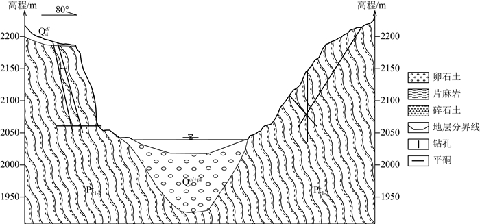
图 2 易贡藏布河谷地貌及典型工程地质剖面图
Pt1-2—古-中元古界;Q4dl—第四系全新统坡积层;Q4al+pl—第四系全新统冲洪积层
Figure 2. Morphology and engineering geological profile of the Yiong Tsangpo River Valley
![]()
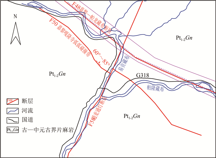
图 3 研究区地质构造示意图
Figure 3. Simplified geological map showing structure in the study area
![]()
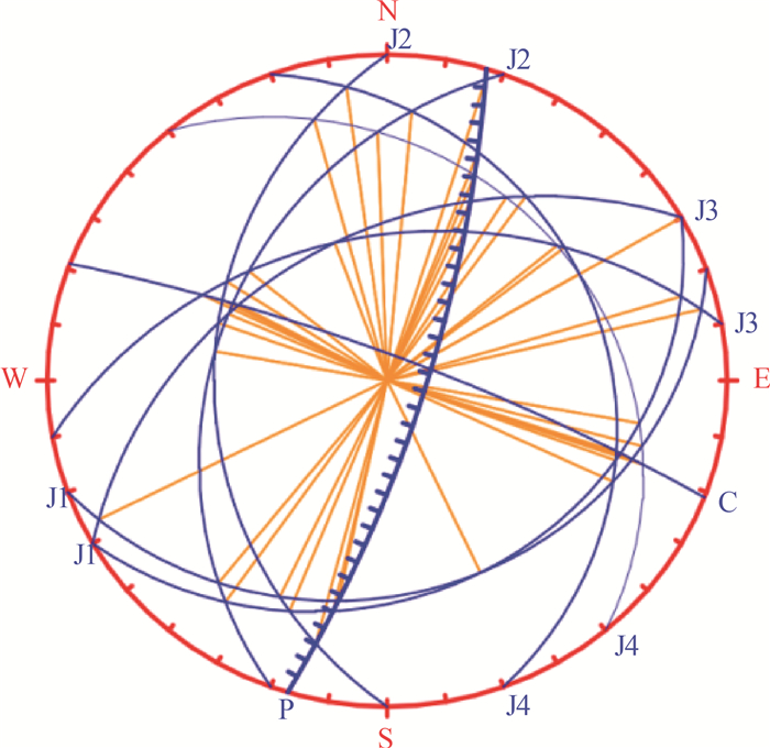
图 4 易贡藏布西侧岸边坡赤平投影图
J1~J4—节理;P—边坡;c—面理
Figure 4. Stereogram of west bank slope of the Yiong Tsangpo
![]()
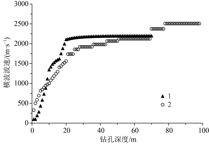
图 5 钻孔Z1和Z3内纵波波速随深度变化规律
Figure 5. Variation of longitudinal wave velocity with depth in boreholes Z1 and Z3
![]()
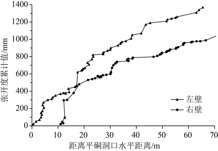
图 7 平硐裂隙张开度累积值分布规律
Figure 7. Distribution law of cumulative value of crack opening in adit
![]()
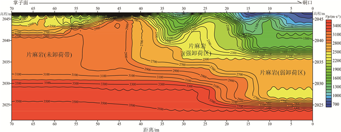
图 8 平硐内地震物探解译成果与卸荷分带
Figure 8. Results of interpretation and unloading zoning of seismic objects in the interior of adit
![]()
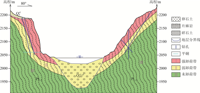
图 9 易贡藏布典型边坡卸荷分区图
Pt1-2—古-中元古界;Q4dl—第四系全新统坡积层;Q4al+pl—第四系全新统冲洪积层
Figure 9. Unloading zoning of the slope in the Yiong Tsangpo
![]()
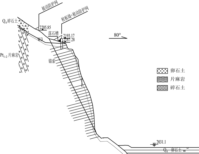
图 10 易贡藏布河谷边坡防护示意图
Q4—第四系全新统;Pt1-2—古-中元古界
Figure 10. Slope protection map of the slope of the Yiong Tsangpo
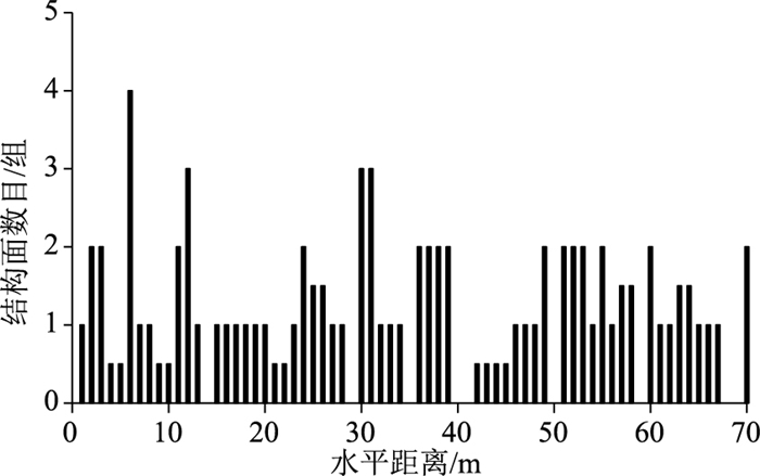
表 1 易贡藏布两岸边坡岩体优势结构面组产状
Table 1 The occurrence of dominant structural plane group of slope rock mass on both sides of the Yiong Tsangpo
位置 结构面类型 倾向/° 倾角/° 延展性 左岸边坡,坡向287°(昌都侧) 面理C 359 51 节理J1 143 19 贯通性好 节理J2 280 50 节理J3 109 65 节理J4 35 45 右岸边坡,坡向107°(林芝侧) 面理C 21 81 节理J1 155 24 贯通性非常好 节理J2 279 36 贯通性好 节理J3 109/287 77 节理J4 60 35  下载: 导出CSV
表 2 易贡藏布东岸工程岩体综合评价与分级
Table 2 Comprehensive evaluation and classification of rock mass in east bank of the Yiong Tsangpo
典型钻孔岩心段/m 工程岩体评价与分级 Q法 RMR法 CSMR法 RQD法 综合评价 0~3 差-Ⅲ 一般-Ⅲ 一般-Ⅲ 较差-Ⅲ Ⅲ 3~15 一般-Ⅲ 好-Ⅱ 很好-Ⅰ 好-Ⅰ Ⅲ 15~25 一般-Ⅲ 好-Ⅱ 好-Ⅱ 较好-Ⅱ Ⅲ 25~44 好-Ⅱ 好-Ⅱ 很好-Ⅰ 好-Ⅰ Ⅱ 44~50 好-Ⅲ 好-Ⅱ 好-Ⅱ 较差-Ⅲ Ⅲ 50~69 好-Ⅱ 非常好-Ⅰ 很好-Ⅰ 好-Ⅰ Ⅱ 69~76 好-Ⅱ 好-Ⅱ 好-Ⅱ 较差-Ⅲ Ⅱ 76~80 好-Ⅱ 非常好-Ⅰ 很好-Ⅰ 好-Ⅰ Ⅱ
下载: 导出CSV
表 3 岩体和结构面力学参数
Table 3 Mechanical parameters of rock mass and structural plane
参数 强卸荷岩体 结构面 天然 暴雨 天然 暴雨 体积模量K(kPa)或法线刚度Kn(kPa/m2) 7.89×10⁶ 6.5×10⁶ 2×10⁴ 1.6×10⁴ 剪切模量G(kPa)或切向刚度Ks(kPa/m2)
5.43×1064.5×106 2×10⁴ 1.6×10⁴ 黏聚力/kPa 2130 2000 80 50 内摩擦角/° 30 28 16 12
下载: 导出CSV
表 4 不同工况下楔形体破坏的稳定性系数
Table 4 Stability coefficient of wedge failure under different working conditions
计算工况 天然 暴雨 地震 稳定性系数 2.91 2.04 1.97
下载: 导出CSV
-
彭少文, 贺金明, 孙冠军, 等. 高陡边坡深部卸荷张拉裂缝的成因机制探讨[J]. 人民长江, 2015, 46(14): 32-35. https://www.cnki.com.cn/Article/CJFDTOTAL-RIVE201514010.htm 黄润秋, 林峰, 陈德基, 等. 岩质高边坡卸荷带形成及其工程性状研究[J]. 工程地质学报, 2001, 9(3): 227-232. doi: 10.3969/j.issn.1004-9665.2001.03.001 王兰生, 李文纲, 孙云志. 岩体卸荷与水电工程[J]. 工程地质学报, 2008, 16(2): 145-153. doi: 10.3969/j.issn.1004-9665.2008.02.001 何书涛, 邓辉, 伍小军, 等. 班达水电站下坝址卸荷带特征研究[J]. 人民珠江, 2020, 41(6): 44-52. doi: 10.3969/j.issn.1001-9235.2020.06.008 姚鑫, 李凌婧, 张永双, 等. 青藏高原东缘区域地壳稳定性评价[J]. 地质通报, 2015, 34(1): 32-44. doi: 10.3969/j.issn.1671-2552.2015.01.003 周洪福, 冯治国, 石胜伟, 等. 川藏铁路某特大桥成都侧岸坡工程地质特征及稳定性评价[J]. 水文地质工程地质, 2021, 48(5): 112-119. https://www.cnki.com.cn/Article/CJFDTOTAL-SWDG202105012.htm 游敏, 聂德新. 河谷斜坡卸荷综合分带研究[J]. 人民黄河, 2011, 33(1): 103-105. doi: 10.3969/j.issn.1000-1379.2011.01.044 郑达, 黄润秋. 西南水电工程坝址峨眉山玄武岩卸荷分带研究[J]. 成都理工大学学报(自然科学版), 2009, 36(2): 195-200. doi: 10.3969/j.issn.1671-9727.2009.02.015 李日运, 刘田珂. 岸坡应力场及卸荷带划分量化指标研究[J]. 华北水利水电大学学报(自然科学版), 2014, 35(2): 76-80. doi: 10.3969/j.issn.1002-5634.2014.02.018 郑达, 黄润秋. 高边坡岩体卸荷带划分的量化研究[J]. 水文地质工程地质, 2006, 33(5): 9-12. doi: 10.3969/j.issn.1000-3665.2006.05.002 郝文忠, 刘冲平, 王吉亮, 等. 乌东德水电站边坡岩体卸荷特征及稳定性评价[J]. 人民长江, 2015, 46(14): 12-15. https://www.cnki.com.cn/Article/CJFDTOTAL-RIVE201514004.htm 朱容辰. 边坡岩体卸荷分带性研究[J]. 铁道勘察, 2010, 36(5): 46-50. doi: 10.3969/j.issn.1672-7479.2010.05.014 马宇, 任光明, 罗轶, 等. 岩质斜坡卸荷分带量化指标与应用研究[J]. 人民长江, 2013, 44(7): 33-35. doi: 10.3969/j.issn.1001-4179.2013.07.009 尹健民, 艾凯, 刘元坤, 等. 钻孔弹模法评价小湾水电站坝基岩体卸荷特征[J]. 长江科学院院报, 2006, 23(4): 44-46. doi: 10.3969/j.issn.1001-5485.2006.04.010 周黎明, 肖国强, 王法刚, 等. 边坡岩体风化卸荷特征研究及在姚家坪水利工程中的应用[J]. 长江科学院院报, 2014, 31(11): 81-86. doi: 10.3969/j.issn.1001-5485.2014.11.017 陈洪凯, 易丽云, 唐红梅. 开挖岩体边坡卸荷带宽度的计算方法[J]. 防灾减灾工程学报, 2011, 31(4): 358-363. https://www.cnki.com.cn/Article/CJFDTOTAL-DZXK201104003.htm 黄勇, 孟祥连, 胡卸文, 等. 雅安至林芝交通廊道重大工程地质问题与对策研究[J]. 工程地质学报, 2021, 29(2): 307-325. https://www.cnki.com.cn/Article/CJFDTOTAL-GCDZ202102003.htm 许强, 王士天, 柴贺军, 等. 西藏易贡特大山体崩塌滑坡事件[J]. 爆破, 2007, 24(12): 41-46. https://cpfd.cnki.com.cn/Article/CPFDTOTAL-ZGYJ200712001013.htm 李俊, 陈宁生, 邓明枫. 西藏林芝扎木弄沟泥石流规模变化趋势研究[J]. 人民长江, 2017, 48(23): 61-65. https://www.cnki.com.cn/Article/CJFDTOTAL-RIVE201723013.htm 中华人民共和国国家标准: GB/T 50218-2014. 工程岩体分级标准[S]. 北京: 中国计划出版社, 2014. 黄海宁, 巨能攀, 黄健, 等. 郑万高铁宜万段边坡危岩崩落破坏特征[J]. 水文地质工程地质, 2020, 47(3): 164-172. https://www.cnki.com.cn/Article/CJFDTOTAL-SWDG202003021.htm 张加桂, 张永双, 曲永新. 滇藏铁路沿线滇藏交界段劈理化带成因探讨及工程效应分析[J]. 地球学报, 2009, 30(6): 885-892. doi: 10.3321/j.issn:1006-3021.2009.06.021 蔡荣坤, 戴自航, 徐根连, 等. 降雨对花岗岩风化层路堑边坡滑动模式影响——以福建云平高速云霄段为例[J]. 中国地质灾害与防治学报, 2021, 32(2): 27-35. https://www.cnki.com.cn/Article/CJFDTOTAL-ZGDH202102004.htm 陈笑楠, 张慧梅. 顺层边坡岩体结构的分岔灾变条件[J]. 中国地质灾害与防治学报, 2020, 31(1): 30-35. https://www.cnki.com.cn/Article/CJFDTOTAL-ZGDH202001006.htm
计量
- 文章访问数:
- HTML全文浏览量: 0
- PDF下载量:
