Assessment of agricultural production suitability in Nantong City based on ArcGIS technology
-
摘要:
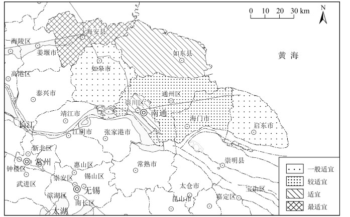
针对环境变化引起的区域农业生产适应性变化、农作物种植结构改变、产业布局调整,以南通市为研究对象,以积温、年降水量、土壤肥力、土壤重金属共同构建农业生产因素评价体系,探究南通市的农业生产适应性情况。结果显示,南通市积温值较高且年际变化大体呈递增趋势。降水量年际变化浮动大,随年份增加呈现先增后减的趋势,日照时数与降水量的变化特征呈负相关。土壤全氮与有效磷含量均满足土壤养分标准二级要求,速效钾含量仅达到四级标准要求。土壤重金属内梅罗综合污染指数在0.26~0.4之间,说明土壤环境质量安全。基于ArcGIS技术采用空间分析等技术手段,将南通地区的农业适宜区分为4级,海安为一级适宜区(最适宜),南通市辖区与如东为二级适宜区,通州、海门为三级适宜区,启东、如皋为四级适宜区。通过南通市农业生产适宜性评价,为今后南通地区科学的农作物生产布局、国土空间规划提供参考依据。
Abstract:Based on the regional adaptation of agricultural production, the change of crop planting structure and the industrial layout adjustment, as a result of environmental change, Nantong City was selected to build an evaluation system of agricultural production factors with accumulated temperature, annual precipitation, soil fertility, soil heavy metals and slope advantages.The results show the accumulated temperature of Nantong City is high and the interannual variation is generally increasing.The interannual variation of precipitation fluctuates greatly with a trend of firstly increasing and then decreasing over the years.There is a negative correlation between the sunshine duration and the variation of precipitation.Both total nitrogen and the available phosphorus content in soil meet the secondary requirements of soil nutrient standard, while the content of available potassium only meets the requirements of the fourth standard level.The Nemero index of heavy metals in soil is between 0.26 and 0.4, indicating that the environmental quality of soil is safe.Based on ArcGIS technology, spatial analysis and other technical methods are used to classify agricultural areas of Nantong into 4 levels.As a result, Haian is rated as the first-tier suitable area (the most suitable), municipal district of Nantong City and Rudong as the secondary one, Tongzhou and Haimen as the third one, and Qidong and Rugao are rated as the fourth one.The evaluation of agricultural production suitability in Nantong City is expected to provide a reference for layout of crop production and territorial space planning scientifically and rationally.
-
随着城市化进程的加快与人口数量迅速增多,生态环境变化对农业生产的影响已成为全球范围重点关注的问题之一[1]。据《全国生态环境十年变化(2000—2010年)调查评估报告》调查结果表明,全国生态安全形势极为严峻,生态保护与发展矛盾突出,主要表现在农业生产与开发导致的水土流失、土地沙化等问题加剧。中国作为以农业生产为国民经济基础的国家,农业生产的合理布局及可持续发展一直受到政府部门高度重视。在《中共中央、国务院关于建立国土空间规划体系并监督实施的若干意见》中指出“要在资源环境承载能力和国土空间开发适宜性评价的基础上,科学有序统筹布局生态、农业、城镇等功能空间”。
土地生产及农业适宜评估是农业区域开发与规划的重要步骤,这一领域国外研究多与GIS技术有机结合且多注重模型构建及单一作物的GIS应用[2-3]。Stork等[4]基于GIS方法在区域尺度上利用供水条件及土壤质量两大因素来评价薪柴生产潜力区域。Kumar等[5]采用频率比(FR)、层次分析法(AHP),结合遥感(RS)和地理信息系统(GIS)多重手段共同探索潜在的农业用地,对制定研究区可持续农业管理计划具有极好作用。Javad等[6]基于遥感(RS)和GIS技术,采用层次分析法和物质元素技术来评估和绘制大麦的种植布局,实验结果表明层次分析法和物质元素技术混合可使模型准确度更高。而国内研究偏重于应用,早期多以与农业生产相关的土壤、气候、地形等单一因素或单一植被展开研究。如土壤重金属元素的来源辨识、对生态环境污染风险的评价研究[7-9],或土壤养分含量动态变化跟踪及土培对策研究[10-12]。土地利用方式引起的土壤理化性质及生态效应变化等方面也有研究[13-15]。此外,在降水量变化特征及自然灾害对农业生产影响方面的研究也较为广泛[15-18]。现阶段随着国土空间规划相关政策提出,“资源环境承载能力与国土空间开发适宜性”(简称“双评价”)研究也逐渐开展[19-22]。总体看,已有研究大多具有较强的针对性和单一性,而关于不同时间尺度下的区域农业生产环境变化开展的农业适宜性评价鲜有报道。
本文运用ArcGIS的空间分析方法,采用南通市近年来气候条件变化、土壤肥力与土壤重金属污染情况等评价因子加权求和的方式,对南通市县市地区的农业生产适宜性进行分析,为1:50万精度及大比例尺图件关于农业生产要素的区域分析及动态变化影响分析提供参考方法,为推进南通市及更小尺度范围的地区了解区域农业生产环境变化并制定相应环境改善政策、开展农作物产业布局研究、识别农业生产合理区、国土空间规划方案制定提供依据支持。
1. 研究区概况
南通市地处江苏省东南部,处于沿海经济带与长江经济带T字形交汇中心,富集“黄金海岸”与“黄金水道”两大优越的空间地理位置资源,是长江流域重要的港口城市之一,也是中国沿海地区土地资源最丰富的地区之一。南通市凭借其独特的地理位置与丰富的自然资源已成为国内沿海地区农业优质发展的典型地区。南通市属长江三角洲冲积平原,全境地势平坦,多数地区海拔在2~6 m之间。全市现有耕地44.87×10⁴ m2,以水田和旱地为主,当地农业产品以粮棉为主,盛产棉花和特种经济作物,耕地产出率高于全省平均水平[9]。南通市土壤多为水稻土、潮土及滨海盐土,整体土壤肥力较高,呈碱性土质[10]。
已有调查表明,当地年平均气温达到15~17℃,年平均日照时数在1700~2200 h之间,年平均降水量为1000~1100 mm,属于典型的气候温和、光照充足、雨水丰沛的农业适宜区,地处海陆过渡带(滨江临海),受季风影响明显,也是典型的自然灾害频发区。下辖海安县、如东县、如皋市、启东市、海门市,崇川区、港闸区、通州区,考虑到获取数据的重合性,本次研究将崇川区与港闸区合并为南通市辖区。
2. 数据来源与评价体系
2.1 数据来源
本次研究所用数据主要为空间数据和统计数据,其中,空间数据包含南通市行政区划图、南通市基础地理图;统计数据包括积温、年降水量、日照时数、土壤养分、土壤重金属元素含量。积温采用当地一年内日平均气温≥10℃的持续期间日平均气温的总和作为年积温数据;年降水量、日照时数来源于《南通市统计年鉴》(2013—2017);土壤肥力数据、土壤重金属数据来源于土壤肥力普查数据及巩万合等[8, 10]关于南通市土壤肥力及重金属的相关研究。具体如表 1所示。
表 1 数据来源Table 1. Data sources数据名称 数据来源 数据类型 积温 天气网历史天气数据的日平均温度 统计数据 年降水量 《南通市统计年鉴》(2013—2017) 统计数据 日照时数 《南通市统计年鉴》(2013—2017) 统计数据 土壤养分数据 全国第二次土壤普查数据 统计数据 土壤重金属数据 全国第二次土壤普查数据、巩万合等[8, 10]关于南通市土壤肥力及重金属 统计数据 南通市行政区划图 地理信息共享平台(https://www.tianditu.gov.cn) 空间数据 南通市基础地理图 地理信息共享平台(https://www.tianditu.gov.cn) 空间数据 2.2 评价体系构建
农业生产过程极易受多种因素影响,因此结合南通市生态环境特性与农业生产模式,选取积温、年降水量、日照时数、土壤养分(有机质、P、K)、土壤重金属(Cd、Cr、Hg、Pb、As)11个评价指标因子构建农业生产适应性评价体系,如表 2所示。这些评价因子对农业生产影响的范围及强度存在差异,结合南通市实际情况,采用德尔菲法[23-25]将所有指标对当地农业影响的重要程度逐一评分,最终确定各指标权重。在此基础上参考“双评价指南”,并与专家评定结合,共同划定同一因子的适宜程度等级。
表 2 农业生产适应性评价体系Table 2. Evaluation system of agricultural production adaptability评价指标 指标因子 权重 分值 分类 评价指标 指标因子 权重 分值 分类 气候 积温/℃ 0.15 1 < 5000 土壤 土壤磷含量/(mg·kg-1) 0.1 2 50~70 2 5000~5500 3 70~90 3 5500~5700 4 ≥90 4 ≥5700 Cd/(mg·kg-1) 0.05 1 ≥0.2 年降水量/mm 0.1 1 < 1000 2 0.1~0.2 2 1000~1500 3 < 0.1 3 ≥1500 Cr/(mg·kg-1) 0.05 1 ≥60 日照时数/h 0.1 1 1000~1400 2 50~60 2 1400~2200 3 < 50 3 2200~3000 Hg/(mg·kg-1) 0.05 1 ≥0.12 土壤 土壤有机质/% 0.1 1 < 0.6 2 0.1~0.12 2 0.6~1 3 < 0.1 3 1~2 Pb/(mg·kg-1) 0.05 1 ≥25 4 2~3 2 20~25 土壤钾含量/(mg·kg-1) 0.1 1 < 10 3 15~20 2 10~20 4 < 15 3 20~30 As/(mg·kg-1) 0.05 1 ≥8 4 ≥30 2 6~8 土壤钾含量/(mg·kg-1) 0.1 1 < 50 3 < 6 评价单元的综合得分是确定土地开发建设适宜性等级的基础,本次研究通过ArcGIS的空间统计方法,采用11个适宜性评价因子加权求和的数据模型来构建农业生产适宜性指数,计算公式如下所示:
Ti=n∑i=1Wi∗Ci (1) 式中:T代表南通市农业生产适宜性指数及综合得分,i=1,…,n代表第i个评价因子;W表示第i个评价因子的权重;C表示对应的评价因子等级评分。
基于ArcGIS软件平台,以南通市行政区划图为本底,所属县级区域为基本单位,对采集获取的各项数据进行空间叠加分析与属性空间化,构成多因子属性值的综合评价图,进而对南通市农业适宜性程度进行综合评价,划分为农业最适宜区、农业适宜区、农业较适宜区、农业一般适宜区[26-27]。
3. 评价过程与结果
3.1 气候变化
了解区域积温、降水演变规律、区域日照时数,可为农业环境条件筛选适宜种植的作物类型提供参考。
3.1.1 积温年际变化特征
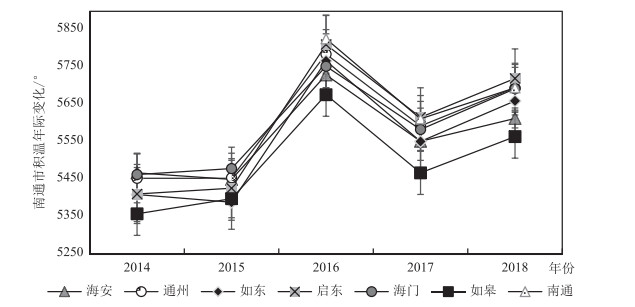
分析积温年际变化有利于对该地区未来的农业生产气候条件做出合理预判。本研究对南通市近5年(2014—2018年)的积温年际变化进行统计,如图 1所示,近5年南通市不同区域积温主要分布在5358.5~5826.5℃之间,年际变化波动幅度较大,随年份递增积温整体呈波动上升趋势,这与王涛等[16]的研究结果一致。对比同一年份南通市各区域之间的积温变化,发现不同地区的积温变化特征基本随年份呈现统一变化规律。经统计,近5年南通市不同区域积温均高于5300℃,产生的热量满足了大部分农作物的需求,属于农业生产的适宜区域。
3.1.2 区域积温空间分布特征
区域积温图可通过直观展示积温具体情况来挖掘其空间分布特征。利用ArcGIS软件平台,以县级区域为单位叠加空间属性将南通市积温分布划分为4类积温区域(综合各地近5年平均积温)。如图 2所示,积温较高区域的温度集中在5563~5712℃之间,主要分布在南通市辖区、通州、海门、启东4个地区,占据了全市47.18%的面积,这部分地区纬度偏低、人口稠密、城市建设用地布局紧张、临江沿海工业聚集程度拥挤,长年处于南通市高积温区域。如东市、海安市区域积温在5494~5563℃之间,处于积温梯度中部,如皋地区积温低于5494℃,处于南通市低积温区域。
3.1.3 降水量与日照时数时间分布特征
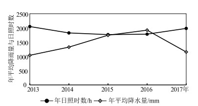
图 3为南通市年均降水量与年日照时数的年际变化情况(2013—2017年),从图中历年降水数据可知,年降水量在2013—2016年基本呈逐年递增趋势,在2016年达到近年降水量最高值1921.4 mm,到2017年降水量陡减,同比上年减少了39.8%,表明南通市年降水量起伏波动变化大,极易受洪涝、干旱等气象灾害影响,因此应重点预测降水受灾风险区,提前做好防护措施,避免农业生产与城市基础设施遭受破坏。年日照时数的变化特征与年降水量完全相反,两者之间的变化规律呈负相关。
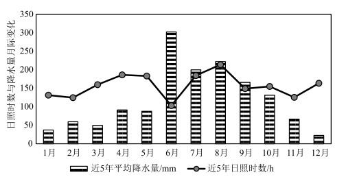
降水量与日照时数的月分布对农作物生长影响、农业环境变化、灾害风险预测提供分析依据。图 4为南通市降水量月分布情况(2013—2017年月平均数据),通过对降水量的分析,发现南通市全年降水大多集中于5~11月之间,占据年降水量的76.2%~86.3%,其中南通地区的降水峰值主要集中在6月中下旬至7月上中旬的梅雨期,因此应在梅雨期前夕做好重点防御工作。月日照时数按时间分布来看,6~7月的光照时数明显偏低,在光照强度与时间不足的条件下农作物难以进行有效的光合作用,进而导致农作物的减产与停产。此外,梅雨期降水集中,空气湿度与土壤湿度大,极易诱发病虫害[21]。
3.1.5 气候变化对南通市农业生产影响分析
农业对气候变化的反应敏感而脆弱,气候变化还会导致农作物生长过程发生改变[28]。南通市现代农业以小麦、大麦、稻谷等粮食作物与大豆、花生、油菜、棉花等经济作物作为主要农作物,农作物产业分布具备如下的地域特点,小麦、大麦、稻谷等粮食作物多分布在海安、如东、如皋等地区,花生、油菜、棉花等经济作物主要集中于启东、海门等沿海地区。南通市主要农作物的产业空间分布在一定程度上符合农作物对气候条件的要求。
根据南通市积温空间分布、降水量与日照特征对照分析,发现高积温气候适宜区域与经济作物分布区域高度重合,高积温区受沿海区位影响有降水量大、日照时数偏小等特点,可见对光热要求较高的油菜、棉花等作物极易受气候变化影响。对于处于粮食主产区、积温梯度中部的如东与海安来讲,气候变化特征与强度可能会对喜长日照的小麦产生影响,相对于喜高温、多湿、短日照的稻谷,气候变化对其影响较小。
总体看,气候变化对不同农作物的影响强度与范围差异性较大,且难以把控气候演变规律,因此可通过调整农田种植结构与农业布局模式、选育良种、加强气候灾害防控等措施来适应气候变化[29]。
3.2 土壤养分
3.2.1 土壤养分年际变化特征
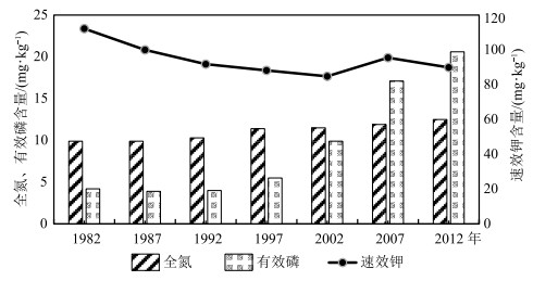
图 5为南通市养分年际变化情况,随年份增加,全氮与有效磷呈递增趋势,土壤全氮含量浮动趋于稳定,至2012年达到12.5 mg/kg,增幅不足27%。有效磷的起伏变化较大,1982—2012年土壤有效磷增幅超过390%,至2012年含量达到20.6 mg/kg。土壤全氮与有效磷的逐年递增主要来自于有机肥的施用,与之相比,土壤速效钾的年际浮动极特殊,自1982—2012年经历了先减少后增加再减少的连续起伏过程。根据全国第二次土壤普查土壤养分分级标准,南通市土壤全氮与有效磷含量均满足土壤养分标准的二级要求,速效钾含量仅达到四级标准要求。
3.2.2 土壤养分评价
利用南通市各区域土壤养分空间分析,将土壤养分划为养分丰富、养分充足、养分较充足及养分基本充足4级(图 6)。海安、如东因土壤养分条件优越,列为土壤养分丰富区,通州、启东养分含量相对有所下滑,划为土壤养分充足地区,市辖区与海门市划为养分较充足区,与其他区域相比,如皋耕地面积相对偏少且土壤养分含量略有不足,可划分为养分基本充足地区。
从农业角度分析,海安与如东是养分丰富的粮食主产区,满足小麦、水稻等作物对土壤养分的需求,可进一步通过调整农业布局增加土壤养分丰富区域的利用率。通州、启东地区土壤养分充足,可达到油菜、蔬菜、棉花等经济作物的养分要求。
3.3 土壤重金属污染
3.3.1 土壤重金属污染统计分析
土壤重金属是评价耕地土壤环境质量的一项重要指标。表 3为南通市土壤重金属Hg、Pb、Cd、As和Cr的元素含量,根据已有研究发现[7-9],江苏省海岸带主要为碱性土壤,pH多集中在7.5~8.5之间,因此参考《土壤环境质量标准》(GB15618—1995)二级标准中土壤pH>7.5的标准值。
依据土壤环境质量标准,南通市土壤重金属含量均符合标准要求。通过对比,南通市各重金属平均含量与江苏省海岸带土壤重金属含量相似度较高,其中Cd元素含量均超过了江苏省土壤背景值,表明南通市及海岸带重金属污染来源可能相似,南通市是重要的粮食基地,有机肥、农药等大量施用增加了土壤养分,也造成了农用地土壤Cd等其他重金属富集。此外,南通市土壤中Hg元素的平均含量较高,这部分Hg的污染源主要来自工业三废与煤炭燃烧,土壤中的Hg元素富集会导致土壤肥力降低,妨碍农作物根系生长,通过食物链进入人体甚至危害人类健康。近年来,南通市第二产业发展迅速,已占据南通GDP比重的48.4%,可见工业发展对农业生产环境的影响极明显。其他重金属元素含量均低于江苏省土壤背景值。
3.3.2 土壤重金属污染评价
图 7为南通市各地区重金属含量,表 4为各地区综合污染指数,根据已有研究对土壤重金属的内梅罗指数进行计算与评价[7]。整体看,南通市各地区的综合污染指数均在0.26~0.4之间,污染程度处于安全阶段。从综合指数的分布看,重金属的分布也存在一定规律,启东的重金属含量最高,通州、海门、南通市辖区3个地区的指数相近,处于0.3~0.32之间,如皋、海安、如东的综合指数较低,可见重金属污染综合指数基本按照南东—北西方向由大到小呈阶梯状分布。沿海地带是工业发展、进出口集散地、人口密集的重要位置,因此由人类活动引发的重金属富集程度较内陆地区有所抬升。总体看,南通市各地区重金属污染对农业生产影响较小。
表 4 南通市各地区单因子指数与内梅罗综合污染指数Table 4. Index of single factor and comprehensive pollution index in different areas of Nantong区域 单因子指数 内梅罗综合指数 Cd Cr Pb As Hg 如皋 0.10 0.13 0.05 0.29 0.09 0.26 海安 0.11 0.13 0.04 0.28 0.09 0.26 启东 0.18 0.17 0.08 0.51 0.09 0.40 如东 0.18 0.15 0.05 0.30 0.09 0.27 通州 0.10 0.14 0.06 0.39 0.14 0.32 海门 0.17 0.16 0.05 0.34 0.10 0.30 南通 0.15 0.14 0.06 0.37 0.12 0.31 3.3.3 土壤重金属相关性分析
多种重金属元素之间的相关性分析基本反映了元素之间的关联情况,有助于辨识重金属污染来源[31]。表 5为土壤重金属之间的相关系数。Cd-Cr、Cr-As之间的Pearson相关性系数为0.792、0.758,p < 0.05,正相关呈显著,Pb-As之间的相关性系数为0.966,通过p < 0.01的检验,说明Pb与As之间的元素相关性很大,元素之间的同源性可能较高。其他元素之间的相关性略低。
表 5 土壤重金属之间的相关系数Table 5. Correlation coefficient among different heavy metals in soil项目 Cd Cr Pb As Hg Cd 1 Cr 0.792* 1 Pb 0.41 0.673 1 As 0.412 0.758* 0.966** 1 Hg -0.361 -0.163 0.214 0.143 1 注:*代表显著性相关(p < 0.05),**代表极显著相关(p < 0.01) 3.4 江苏海岸带滩涂资源与农业利用
土壤盐渍化是海岸带普遍存在的现象之一,海岸带大部分盐渍土主要集中在沿海滩涂,然而滩涂土壤的含盐量在空间分布上的不均与季节变化上的巨大差异导致盐分数据难以利用。海岸滩涂湿地实际是一种具有较强的气候调节、净化环境等功能的土地后备资源,随着土地资源的日渐紧张,大部分滩涂资源已被开发利用,且围垦后超过60%的土地作为耕地资源进行利用[32]。据了解,现今江苏省有超过2/3的海岸带处于淤长状态,每年新淤达到1333 km2[33]。虽然这些利用的滩涂存在含盐量过高的情况,然而随着新淤面积的不断增加,以及逐渐远离海岸与地表径流的冲洗,出露滩涂盐分随之下降。如东县作为南通市的滩涂大县,海平面以上滩涂面积达8×10⁴ hm2,占南通市滩涂面积的50%,具备了持续生长的后备耕地资源[34]。目前改善土壤盐渍化的方法有很多,种植耐盐作物、水稻,添加土壤改良剂,进行秸秆覆盖、植被覆盖、调整耕作方式等人为措施均可达到降盐、控盐的作用[35],由此可见,如东县等沿海地区具有较强的农业发展潜力。
4. 适宜性区域分析
以农业生态环境为背景,按照南通市区域特点,参考相关行业标准依据专家经验评判确定指标权重及分级参数,建立以气候、土壤为主要指标的评价体系(详见2.2部分)。利用ArcGIS空间统计分析、叠加分析等技术为依托,通过对各指标综合分级空间计算统计(自然间断点分级法)与专家评定相结合的方式展开对南通市各县区农业生产适宜性综合性评价。由于南通市各区县气候条件相对适宜,土壤环境指标均在安全范围内,因此本研究讨论了各区县农业生产环境的相对适宜程度。启东的气候条件及土壤养分条件尚可,而土壤重金属单因子指数及内梅罗指数相对偏高且分值较低设置为一般适宜区域(四级适宜区),可种植如棉花这类重金属耐受性较好的经济作物,建立农产品加工生产基地,也可充分利用区位优势发展水产养殖业。如皋区位条件及连续性耕作,导致了该地气候及土壤养分等指标的综合分值偏低,也划分为一般适宜区范围,区内大多为砂壤土、中壤土等土质也可种植山药、马铃薯及四季蔬菜等。南通各县区中海安的综合分值最高,主要是土壤养分及土壤环境安全等指标级别较高所致,可适合大多数农作物种植。如东县与海安县情况类似,与南通市辖区划分为农业适宜生产区域也称为二级适宜区,可大规模种植四季蔬菜,因其低洼的地势条件及水源条件也发展水稻种植及水产养殖。而通州市、海门市各指标参数较为均匀,按综合分值划分为三级适宜区,因其优越的地理位置可作为上海市农产品供应基地开发,可大力发展形成蔬菜水果、水稻等需求农产品的种植基地及农业商品加工基地。
5. 结论
(1) 从气候的逐年变化情况看,南通市积温基本呈逐年递增趋势,高积温区多分布在纬度较低地区,如南通市辖区、通州、海门、启东,占据了全市面积的47.18%。降水量年际起伏波动较大,变化复杂,且多与年日照时数关系密切,其变化规律与日照时数呈负相关。
(2) 从土壤养分与质量的逐年变化看,土壤全氮与有效磷呈递增趋势,据全国第二次土壤普查土壤养分分级标准,南通市土壤全氮与有效磷处于土壤养分二级水平,速效钾含量偏低仅达到土壤养分四级要求。从养分富集程度的空间分布看,海安、如东为养分丰富区,通州、启东为养分充足地区,市辖区与海门市划为养分较充足区,如皋为养分基本充足区。
(3) 参照《土壤环境质量标准》,南通市土壤重金属含量均符合标准要求,全市综合污染指数在0.26~0.4之间,处于安全阶段。此外,相关性分析发现Pb与As之间相关性系数较高,元素同源性可能性较高。
(4) 根据农业生产适应性评价,将适宜区划分为4级,海安地区的农业生产环境达到最适宜程度(一级适宜区),南通市辖区与如东为二级农业生产适宜区,通州、海门划分为三级适宜区,启东、如皋为四级适宜区。
致谢: 审稿专家在成文过程中给予了宝贵的意见和建议,在此表示衷心感谢。 -
表 1 数据来源
Table 1 Data sources
数据名称 数据来源 数据类型 积温 天气网历史天气数据的日平均温度 统计数据 年降水量 《南通市统计年鉴》(2013—2017) 统计数据 日照时数 《南通市统计年鉴》(2013—2017) 统计数据 土壤养分数据 全国第二次土壤普查数据 统计数据 土壤重金属数据 全国第二次土壤普查数据、巩万合等[8, 10]关于南通市土壤肥力及重金属 统计数据 南通市行政区划图 地理信息共享平台(https://www.tianditu.gov.cn) 空间数据 南通市基础地理图 地理信息共享平台(https://www.tianditu.gov.cn) 空间数据 表 2 农业生产适应性评价体系
Table 2 Evaluation system of agricultural production adaptability
评价指标 指标因子 权重 分值 分类 评价指标 指标因子 权重 分值 分类 气候 积温/℃ 0.15 1 < 5000 土壤 土壤磷含量/(mg·kg-1) 0.1 2 50~70 2 5000~5500 3 70~90 3 5500~5700 4 ≥90 4 ≥5700 Cd/(mg·kg-1) 0.05 1 ≥0.2 年降水量/mm 0.1 1 < 1000 2 0.1~0.2 2 1000~1500 3 < 0.1 3 ≥1500 Cr/(mg·kg-1) 0.05 1 ≥60 日照时数/h 0.1 1 1000~1400 2 50~60 2 1400~2200 3 < 50 3 2200~3000 Hg/(mg·kg-1) 0.05 1 ≥0.12 土壤 土壤有机质/% 0.1 1 < 0.6 2 0.1~0.12 2 0.6~1 3 < 0.1 3 1~2 Pb/(mg·kg-1) 0.05 1 ≥25 4 2~3 2 20~25 土壤钾含量/(mg·kg-1) 0.1 1 < 10 3 15~20 2 10~20 4 < 15 3 20~30 As/(mg·kg-1) 0.05 1 ≥8 4 ≥30 2 6~8 土壤钾含量/(mg·kg-1) 0.1 1 < 50 3 < 6 表 3 南通市土壤重金属含量分析
Table 3 Analysis of heavy metal content in soil of Nantong
mg/kg 表 4 南通市各地区单因子指数与内梅罗综合污染指数
Table 4 Index of single factor and comprehensive pollution index in different areas of Nantong
区域 单因子指数 内梅罗综合指数 Cd Cr Pb As Hg 如皋 0.10 0.13 0.05 0.29 0.09 0.26 海安 0.11 0.13 0.04 0.28 0.09 0.26 启东 0.18 0.17 0.08 0.51 0.09 0.40 如东 0.18 0.15 0.05 0.30 0.09 0.27 通州 0.10 0.14 0.06 0.39 0.14 0.32 海门 0.17 0.16 0.05 0.34 0.10 0.30 南通 0.15 0.14 0.06 0.37 0.12 0.31 表 5 土壤重金属之间的相关系数
Table 5 Correlation coefficient among different heavy metals in soil
项目 Cd Cr Pb As Hg Cd 1 Cr 0.792* 1 Pb 0.41 0.673 1 As 0.412 0.758* 0.966** 1 Hg -0.361 -0.163 0.214 0.143 1 注:*代表显著性相关(p < 0.05),**代表极显著相关(p < 0.01) -
郭佳, 张宝林, 高聚林, 等. 气候变化对中国农业气候资源及农业生产影响的研究进展[J]. 北方农业学报, 2019, 47(1): 105-113. doi: 10.3969/j.issn.2096-1197.2019.01.18 Zhang L, Song W, Song W. Assessment of agricultural drought risk in the Lancang-Mekong Region, South East Asia[J]. International Journal of Environmental Research and Public Health, 2020, 17(17): 6153-6176. doi: 10.3390/ijerph17176153
Wielemaker R, Wilken C, Chen W S, et al. Resource Dynamo: A GIS model to match urban nutrient supply with agricultural demand[J]. Journal of Cleaner Production, 2020, 258: 120789. doi: 10.1016/j.jclepro.2020.120789
Stork M, Schulte A, Murach D. Large-scale fuelwood production on agricultural fields in mesoscale river catchments-GIS-based determination of potentials in the Dahme river catchment(Brandenburg, NE Germany)[J]. Biomass and Bioenergy, 2014, 64: 42-49. doi: 10.1016/j.biombioe.2014.03.029
AK A, MPb C, SC A, et al. Land evaluation for sustainable development of Himalayan agriculture using RS-GIS in conjunction with analytic hierarchy process and frequency ratio[J]. Journal of the Saudi Society of Agricultural Sciences, 2021, 20(1): 1-17. doi: 10.1016/j.jssas.2020.10.001
Seyedmohammadi J, Sarmadian F, Jafarzadeh A A, et al. Development of a model using matter element, AHP and GIS techniques to assess the suitability of land for agriculture[J]. Geoderma, 2019, 352: 80-95. doi: 10.1016/j.geoderma.2019.05.046
吕建树. 江苏典型海岸带土壤及沉积物重金属环境地球化学研究[D]. 南京大学博士学位论文, 2015. 巩万合, 王志强, 郁伟, 等. 南通市农田土壤重金属含量及评价[J]. 黑龙江农业科学, 2014, (10): 34-39. https://www.cnki.com.cn/Article/CJFDTOTAL-HLJN201410010.htm 巩万合, 王志强, 阚建鸾. 长三角典型农业区耕地土壤重金属污染与潜在生态风险评价[J]. 湖北农业科学, 2017, 56(23): 4493-4496. https://www.cnki.com.cn/Article/CJFDTOTAL-HBNY201723018.htm 巩万合, 郁伟, 王志强, 等. 南通市耕地土壤肥力演变趋势及培肥对策[J]. 现代农业科技, 2014, (8): 189-191. doi: 10.3969/j.issn.1007-5739.2014.08.119 巩万合, 杨连飞, 刘蓉蓉, 等. 江苏南通地区耕层土壤微量元素含量与有效性评价[J]. 江苏农业科学, 2014, 42(11): 378-380. https://www.cnki.com.cn/Article/CJFDTOTAL-JSNY201411134.htm 金成伟, 闫德智, 贾凤薇. 南通市不同农业土地利用方式对土壤理化性质的影响[J]. 江苏农业科学, 2013, 41(6): 336-339. doi: 10.3969/j.issn.1002-1302.2013.06.121 于淼, 吕晓, 廉丽姝, 等. 江苏省沿海地区土地利用变化及其生态效应[J]. 水土保持通报, 2017, 37(3): 131-139. https://www.cnki.com.cn/Article/CJFDTOTAL-STTB201703023.htm 宁立新, 周云凯, 张启斌, 等. 近19年江苏海岸带地区土地利用变化特征[J]. 水土保持研究, 2017, 24(4): 227-233. https://www.cnki.com.cn/Article/CJFDTOTAL-STBY201704038.htm 王雪薇, 董增川, 韩锐. 江苏省东台市近65年气温和降水量特征分析[J]. 水电能源科学, 2017, 35(11): 6-9, 21. https://www.cnki.com.cn/Article/CJFDTOTAL-SDNY201711002.htm 王涛, 陶辉, 杨强. 南通地区1960年-2007年气温与降水的年际和季节变化特征[J]. 资源科学, 2011, 33(11): 2080-2089. https://www.cnki.com.cn/Article/CJFDTOTAL-ZRZY201111011.htm 仇娟娟, 宋正逵, 周荣, 等. 南通市洪涝灾害案例分析与对策探讨[J]. 中国西部科技, 2014, 13(9): 57-59. doi: 10.3969/j.issn.1671-6396.2014.09.025 陈烨丽. 气象灾害对南通市通州区蔬菜生产的影响及防御措施[J]. 上海农业科技, 2016, (5): 27-28. doi: 10.3969/j.issn.1001-0106.2016.05.014 黄燕如, 郑玉萍, 廖楠. 基于国土空间规划背景的双评价应用研究——以广州市番禺区生态适宜性评价为例[J]. 现代信息科技, 2020, 4(11): 121-125. https://www.cnki.com.cn/Article/CJFDTOTAL-XDXK202011041.htm 严圣华, 黄跃飞, 熊娟, 等. 基于"双评价"的市县土地资源评价——以大冶市为例[J]. 国土与自然资源研究, 2020, 000(001): 43-47. https://www.cnki.com.cn/Article/CJFDTOTAL-GTZY202001010.htm 杜海娥, 李正, 郑煜. 资源环境承载能力评价和国土空间开发适宜性评价研究进展[J]. 中国矿业, 2019, 28(S2): 159-165. https://www.cnki.com.cn/Article/CJFDTOTAL-ZGKA2019S2036.htm 李瑞敏, 殷志强, 李小磊, 等. 资源环境承载协调理论与评价方法[J]. 地质通报, 2020, 39(1): 80-87. http://dzhtb.cgs.cn/gbc/ch/reader/view_abstract.aspx?file_no=20200108&flag=1 王忠蕾, 张训华, 许淑梅, 等. 海岸带地区环境承载能力评价研究综述[J]. 海洋地质动态, 2010, 26(8): 28-34. https://www.cnki.com.cn/Article/CJFDTOTAL-HYDT201008007.htm 陈武, 李瑞敏, 殷志强, 等. 贵州乌蒙山毕节市七星关区资源环境承载能力评价[J]. 地质通报, 2020, 39(1): 114-123. http://dzhtb.cgs.cn/gbc/ch/reader/view_abstract.aspx?file_no=20200113&flag=1 曾毅, 项广鑫, 蒋星祥, 等. 基于国土空间自然适宜性的三类空间划分方法——以湖南省为例[J]. 地质通报, 2020, 39(1): 138-145. http://dzhtb.cgs.cn/gbc/ch/reader/view_abstract.aspx?file_no=20200116&flag=1 丰继林, 刘帅, 黄猛. Excel数据与GIS空间数据转换技术研究[J]. 中国新通信, 2013, 15(10): 90-91. doi: 10.3969/j.issn.1673-4866.2013.10.070 董敏, 孙宝生, 陈川. 基于ArcGIS的地质图图例绘制及意义——以《西准噶尔地区地质图》为例[J]. 新疆地质, 2010, 28(1): 116-118. doi: 10.3969/j.issn.1000-8845.2010.01.023 葛全胜, 陈泮勤, 方修琦, 等. 全球变化的区域适应研究: 挑战与研究对策[J]. 地球科学进展, 2004(4): 516-524. doi: 10.3321/j.issn:1001-8166.2004.04.005 钱凤魁, 王文涛, 刘燕华. 农业领域应对气候变化的适应措施与对策[J]. 中国人口资源与环境, 2014, 24(5): 19-24. https://www.cnki.com.cn/Article/CJFDTOTAL-ZGRZ201405004.htm 廖启林, 刘聪, 金洋, 等. 江苏土壤地球化学分区[J]. 地质学刊, 2011, 35(3): 225-235. doi: 10.3969/j.issn.1674-3636.2011.03.225 Lv J, Liu Y, Zhang Z, et al. Distinguishing anthropogenic and natural sources of trace elements in soils undergoing recent 10-year rapid urbanization: a case of Donggang, Eastern China[J]. Environmental Science and Pollution Research, 2015, 22(14): 10539-10550. doi: 10.1007/s11356-015-4213-4
马志军. 江苏省盐城市沿海滩涂资源可持续开发利用研究[D]. 南京农业大学硕士学位论文, 2006. 毛桂囡, 龚政, 赵立梅, 等. 江苏入海河道河口治导线研究[J]. 河海大学学报(自然科学版), 2010, 38(4): 462-466. doi: 10.3876/j.issn.1000-1980.2010.04.021 杨宏忠. 关于海岸滩涂资源投资开发模式的探讨[J]. 中国农垦, 2012, (12): 55-57. doi: 10.3969/j.issn.0529-6382.2012.12.022 张蛟, 冯芝祥, 崔世友, 等. 滩涂垦区不同盐分水平土壤的盐分动态及土壤因子变化[J]. 江苏农业报, 2017, 33(4): 836-842. https://www.cnki.com.cn/Article/CJFDTOTAL-JSNB201704018.htm


 下载:
下载:
