Fault characteristics and tectonic evolution model of the East Timor trough
-
摘要:
东帝汶海槽位于澳大利亚板块西北帝汶海与帝汶岛之间,晚中新世澳大利亚板块与东南亚班达岛弧碰撞引发了帝汶岛与帝汶海槽的构造变形,由于弧-陆碰撞过程的复杂性,帝汶海槽的变形时间与机制仍然存在较大争议。为约束帝汶海槽变形时间、探讨其演化过程,依据二维地震数据,对东帝汶海槽的断裂特征进行定量分析,并结合钻井与天然地震事件探讨弧-陆碰撞背景下帝汶海槽的构造演化模式。研究结果表明,晚中新世(约6 Ma)澳大利亚板块与班达岛弧碰撞,引发了帝汶岛的隆升与帝汶海槽的沉降,变形持续至晚上新世(约3 Ma),形成现今帝汶海槽形态。现今澳大利亚板块与班达岛弧之间的相对运动速率已逐渐减小趋于停止,未来二者可能会以一个整体继续向北运动。
Abstract:The East Timor trough is located on the boundary between the Australian plate and the Eurasian plate, whose tectonic deformation was caused by the collision between the Australian plate and the Banda arc in southeastern Asia during Late Miocene. Due to the complexity of the arc-continent collision process, the deformation time and mechanism of the Timor trough are still controversial. In order to limit the deformation time of the Timor trough and discuss its evolution process, the fault characteristics of the Timor trough were quantitatively analyzed based on two-dimensional seismic data, and its tectonic evolution model under the background of arc-land collision was discussed in combination with drilling and natural seismic events.The results show that the Australia plate collided with the Banda island arc in the Late Miocene (about 6 Ma), which triggered the uplifting and subsidence of the Timor trough. The deformation lasted until the Late Pliocene(about 3 Ma), forming the present Timor trough. At present, the relative movement rate between the Australian plate and the Banda island arc has gradually decreased toward a halt. In the future, they may continue to move northward as a whole.
-
Keywords:
- Timor trough /
- arc-continent collision /
- fault characteristics /
- earthquakes /
- tectonic evolution
-
东帝汶海槽位于澳大利亚西北部帝汶海与帝汶岛之间,地处澳大利亚板块西北边缘,是太平洋与印度洋之间印尼贯穿流(Indonesian Throughflow, ITF)的重要通道之一。晚中新世澳大利亚板块与东南亚班达岛弧的碰撞引发了帝汶岛的隆升与帝汶海槽的沉降[1-6],形成澳大利亚板块与东南亚板块之间的复杂构造带。弧-陆碰撞的轨迹、时间仍然存在争议,帝汶海槽的变形时间与过程也存在差异;同时动物地理分区与地质物源研究结果存在较大差异,欧亚板块东南缘与澳大利亚板块的界线尚不明确,因此还引发了帝汶海槽是否为俯冲带的争议[3-9]。现有研究认为,弧-陆碰撞开始于晚中新世9.8~5.7 Ma[7-8],帝汶海槽开始变形,晚上新世—第四纪4~2 Ma碰撞逐渐停止[8-9],形成现今的海槽形态。
本文在前人研究的基础上,依据东帝汶海槽总长6500 km的二维地震数据,系统总结了东帝汶海槽区域断裂分布与活动性特征;结合DSDP钻井与天然地震事件分布,约束帝汶海槽变形时间,探讨帝汶海槽的构造演化模式与弧-陆碰撞的关键时间节点,为帝汶海槽的构造演化过程研究提供地质依据与新的认识。
1. 地质背景
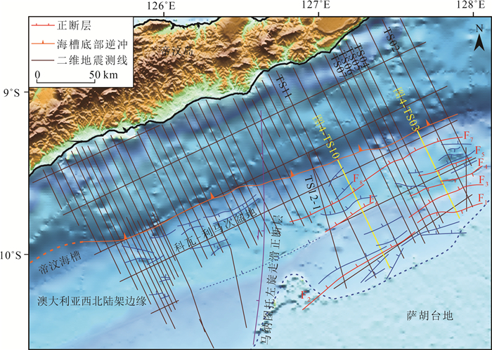
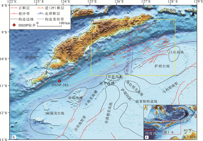
东帝汶海槽即帝汶海槽东段,北部为帝汶岛(Timor)、塔宁巴尔岛(Tanimbar)、阿鲁岛(Aru)组成的外班达弧和与巽他古陆相接的小巽他群岛、韦塔岛(Wetar)、班达海(Banda Sea)岛弧组成的内班达弧,内、外班达弧间隔萨武海(Savu Sea)、翁拜海峡(Ombai Strait)、韦伯深渊(Weber Deep);西部延伸至印度洋,与爪哇海沟东段相接;东南部为澳大利亚西北大陆架,发育一系列台地、盆地等,并以发育一系列正断层为主要特征,整体呈SW—NE向,主要控制了陆架台地与盆地边缘及地垒、地堑带,浅水、温热、光照充足等较好的环境条件促进了台地碳酸盐岩沉积与珊瑚生物礁的发育;海槽西北部由于帝汶岛的抬升与海槽沉降发育一系列叠瓦状逆冲断层,属于半深海海槽向帝汶岛的过渡带,形成多个微型盆地与褶皱。帝汶海槽中部发育一条约150 km长的马纳图托(Manatuto)左旋走滑正断层[10],控制了科瓦-利马次盆地(Cova-Lima sub-basin)的形成(图 1)。
![]() 图 1 东帝汶海槽位置(a)与区域构造图(b)(据参考文献[5]修改)Figure 1. Location(a) and regional structure(b) of the East Timor trough
图 1 东帝汶海槽位置(a)与区域构造图(b)(据参考文献[5]修改)Figure 1. Location(a) and regional structure(b) of the East Timor trough新近纪以来,澳大利亚板块与欧亚板块、太平洋板块发生了多次碰撞,导致了澳大利亚西北部的构造变形。晚中新世前,帝汶岛与班达岛弧隔翁拜海峡相望,晚中新世—晚上新世由于洋壳俯冲殆尽,澳大利亚大陆与班达岛弧发生碰撞,较低的澳大利亚陆壳边缘被挤压至班达岛弧下方,后缘帝汶岛受挤压作用隆升,帝汶海槽开始沉降[11-14]。包括帝汶海槽及其邻域在内的海域沉积序列主要受岩石圈的挠曲控制[15-17],弧-陆碰撞使该区由单一被动离散边缘转化为斜向碰撞汇聚带,造就了由若干个盆地、台地组成的构造带,形成该区域独特的构造模式。周缘岛域的逆冲使中生代裂谷再活化,导致了澳大利亚西北部的变形。澳大利亚西北大陆架由二叠纪—白垩纪的盆地组成,外缘为残留的高地、深海平原和浅海台地,边缘近海SW—NE向构造反映了石炭纪、二叠纪和中生代的裂谷作用,浅海局部同沉积构造作用增强导致中生代和新近纪变形。中生代沉积主要集中在波拿帕特盆地(Bonaparte Basin)的3个狭长沉积带内,包括石炭纪—二叠纪再活化的沃坎(Vulcan)和马利塔(Malita)地堑及残留的萨胡(Sahul)斜坡;新近纪同沉积构造主要集中在残留的马利塔地堑、萨胡斜坡与南卡海槽(Nancar Trough)外侧,以及古沃坎地堑与卡地亚海槽(Cartier Trough)的东北部[18-19]。沿澳大利亚西北边缘的挠曲变形断层活动和逆冲前缘变形持续至今,虽然缺乏明显的断层位移量,但帝汶海槽南部、昆布高地(Laminaria High)和沃坎地堑区存在海底断层,表明沉积速率可能低于断层活动。
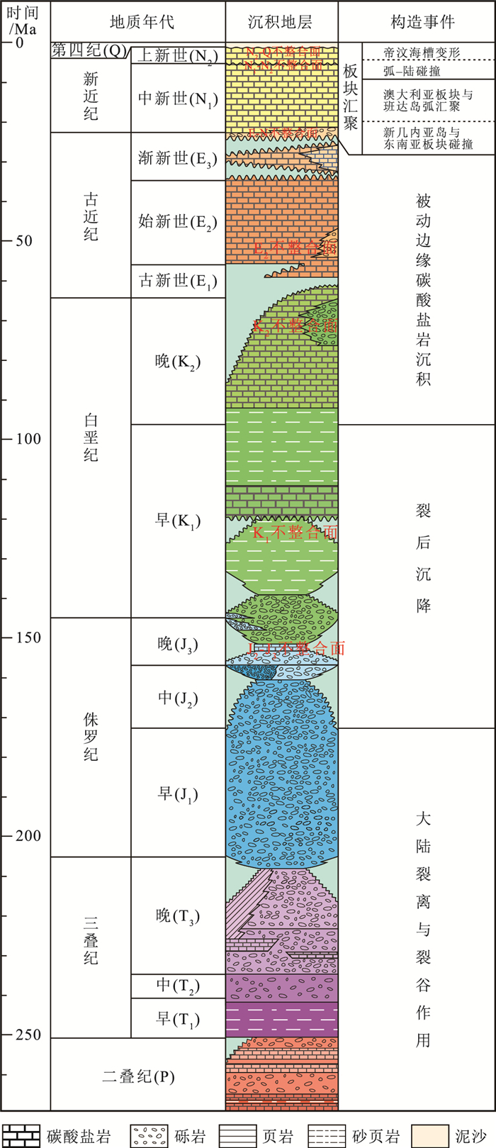
新几内亚岛、澳大利亚西北大陆架、塔宁巴尔岛、帝汶岛、松巴岛(Sumba)的砂岩物源与锆石测年研究结果[20]显示,班达岛弧白垩纪砂岩的物源自西向东不同,松巴岛的砂岩含有大量长石(钾长石和斜长石)和岩屑,表明是岩浆弧成因,而帝汶岛和塔宁巴尔岛砂岩中富含石英,表明其来源于澳大利亚大陆内部。物源研究[20]进一步证明,帝汶岛与帝汶海槽属于澳大利亚板块,帝汶海槽地层与澳大利亚西北陆架地层基本一致,弧-陆碰撞后可能增加了帝汶岛沿岸的物质输入。帝汶岛地层主要来源于原地沉积,部分来源于弧-陆碰撞过程中异地漂积和逆冲推覆的亚洲微板块[21-22],本文在此基础上总结了研究区东帝汶海槽地层系统与主要构造事件(图 2)。
![]() 图 2 东帝汶海槽地层柱状图与构造事件(据参考文献[23]修改)Figure 2. Stratigraphy of the East Timor trough and its tectonic events
图 2 东帝汶海槽地层柱状图与构造事件(据参考文献[23]修改)Figure 2. Stratigraphy of the East Timor trough and its tectonic events2. 数据与方法
本文所用二维地震数据由中国石油集团东方地球物理勘探有限责任公司在2005年采集,采样间隔2 ms,总长6500 km,覆盖面积约33000 km2;DSDP-262钻井数据来自深海大洋钻探计划DSDP-27-262报告及前人研究校正后的生物地层数据;天然地震与震源机制解释数据来自美国地质调查局(USGS)自1900年以来记录的天然地震事件。
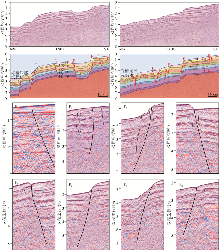
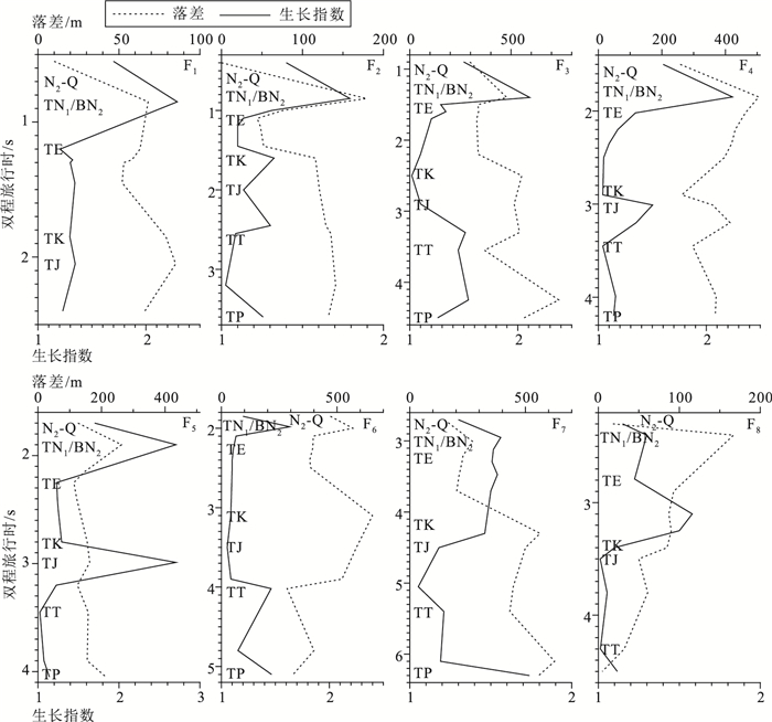
依据钻井与前人研究成果标定的二维地震资料,本文对东帝汶海槽陆架区正断层特征进行了研究,首先对地震解释数据插值形成同一层位反射面,依据各反射层位追踪、识别、统计了研究区断裂带,绘制断裂平面分布图,并对研究区8条主要断裂带运用古落差法与生长指数法进行定量分析(图 3)。古落差法通过统计断层某一时期的落差判断断层的活动性,断层落差反映了断层两盘的下降幅度及沉积充填和隆升剥蚀相对速率等地质信息,落差越大表明断裂活动性越强[24]。断层生长指数是同一地质历史时期上盘沉积层厚度与下盘沉积层厚度的比值,即断层生长指数=上盘沉积层厚度/下盘沉积层厚度。生长指数为1时断层不活动,生长指数大于1时与断层活动性成正比,生长指数小于1时表明断层性质发生反转。断层生长指数之间的相对数值大小可以反映空间和时间上断层活动周期和运动迁移规律[25-26]。受地层压实作用、侵蚀、剥蚀等因素影响,断层落差与生长指数分析必然存在一定误差,且两种分析方法本身存在其优缺点,本文将两种方法结合对比,能减少误差带来的影响,更客观地反映研究区的断裂活动变化。
3. 区域断裂活动特征定量分析
东帝汶海槽南部陆架区主要发育一系列正断层,控制了斜坡边缘地垒、地堑构造特征,仍然保留了前陆盆地的形态。大部分主要断层起始于二叠纪同裂谷期,结束于晚上新世—第四纪,晚中新世—晚上新世弧-陆碰撞导致的变形引发了同裂谷期断裂再活化。部分次级断层起始于早三叠世—早侏罗世,随着印缅地块、班达-内班达-阿尔戈(Banda-Inner Banda-Argo)地体的裂离,澳大利亚大陆发生了最后的裂解与裂离,经历了长时间的裂后沉降期,形成侏罗纪—白垩纪的多个不整合面与断层。次级断层主要控制了小型地垒、地堑或凹陷,部分被晚白垩世—古近纪被动大陆边缘碳酸盐岩沉积覆盖,另一部分发育至今,并于晚中新世—晚上新世弧-陆碰撞期再活化。古近纪末期、新近纪以来,澳大利亚板块与东南亚板块的碰撞形成多个不整合面与新的断层,新断层主要发育于晚渐新世—早中新世,规模较小,在晚上新世—第四纪弧-陆碰撞结束后,被较高沉积速率的第四纪沉积填充覆盖(图 4)。
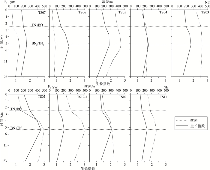
为分析研究区主要断裂活动特征,本文对F1~F8断层运用古落差与生长指数法进行定量分析。结果表明,断层落差与生长指数整体表现为早白垩世前与新近纪以来2个活动高峰(图 5),其中早白垩世前为澳大利亚大陆裂谷作用与裂后沉降阶段,新近纪以来为弧-陆碰撞阶段。澳大利亚西北边缘是由冈瓦纳大陆在寒武纪—白垩纪断裂的泛大陆形成的被动边缘,早期冈瓦纳大陆的断裂影响了二叠纪前期的陆内伸展和裂陷,在澳大利亚西北边缘形成潜在的盆地构造(西澳大利亚超级盆地)。石炭纪—早二叠世,澳大利亚陆内边缘裂谷控制了中生代和新生代的地壳结构,并导致整个边缘范围的凹陷,被厚6~8 km的二叠系—三叠系填充[23, 27-28]。白垩纪之前,澳大利亚大陆构造活动一直较活跃,断层活动性较强;晚侏罗世—早白垩世,随着印缅地块的分离,澳大利亚西北大陆发生了最后的裂解和裂离,深海裂谷经历了长期沉积填充,澳大利亚西北陆架被一层巨厚的被动边缘沉积覆盖;白垩纪晚期之后构造活动相对稳定。新近纪以来,澳大利亚大陆与欧亚板块发生碰撞,碰撞与碰撞导致的边缘变形重新激活了早期裂谷与裂后沉降期古老断层,并形成新的断裂,构造活动再次活跃。早中新世以来,帝汶海槽断层落差与生长指数逐渐增大,表明断裂活动性增加;晚中新世—早上新世(TN1/BN2),断层落差与生长指数达到最大,表明断裂活动性达到顶峰,此时为构造活动的活跃期,澳大利亚大陆与班达岛弧发生碰撞;晚上新世—第四纪(N2—Q),断层落差与生长指数逐渐减小,表明断层活动性减弱,由弧-陆碰撞引发的构造活动逐渐减弱。
依据F1~F8断层落差与生长指数分析结果及剖面特征(图 5),本文将F3、F6划分为一级断裂,F4、F5、F7、F8划分为二级断裂,F1、F2划分为三级断裂。其中一级断裂带主要控制了帝汶海槽的沉降与澳大利亚西北陆架边界;二级断裂主要控制了地垒、地堑特征;三级断裂主要控制了次级凹陷特征。为探讨弧-陆碰撞时期研究区断裂活动特征,本文对F3、F6一级断裂带各剖面新近纪以来的断层落差与生长指数进行定量分析,并分析其活动性。
一级断裂带为发育于二叠纪或更早的古老断裂带,其断裂活动性记录了东帝汶海槽地质历史时期的构造活动强度,并较好地响应了弧-陆碰撞与帝汶海槽的变形。F3与F6断层落差与生长指数变化均较大,落差最大达530 m,生长指数最大2.75(图 6)。由西南至东北方向,F3断层落差与生长指数峰值整体表现为增大趋势,表明晚中新世—晚上新世F3北部断裂活动性高于南部,具有更大的落差与地层厚度差异。F6断裂由于延伸较短,经过地震剖面较少,难以准确描述其横向活动性变化,现有断层定量分析表明,F6断裂带南北落差与生长指数变化不大,活动性差异较小。F3生长指数明显大于F6,特别是晚中新世—晚上新世,F3平均生长指数比F6大约0.5,表明F3断裂上、下盘厚度差异更大。现今剖面特征表明,F3断裂带水深700~800 m,F6水深1500~1600 m,且F6更靠近帝汶海槽,F3位于澳大利亚西北陆架与斜坡交界地带。晚中新世—晚上新世,F3相对浅水的陆架坡折边缘地带水动力条件大于相对深水的陆架斜坡内部F6断裂带,更大的水动力条件使F3断裂上升盘(即下盘)受到海水与洋流的侵蚀,剥蚀作用更强,可能导致了F3断裂更大的上、下盘厚度差异。
新近纪以来断层落差与生长指数整体趋势保持一致,早中新世—晚中新世,断层落差与生长指数缓慢增大,表明澳大利亚板块新几内亚岛与东南亚板块的碰撞引发了澳大利亚西北陆架区域的断裂活动,此时期断层活动性逐渐增加。晚中新世—早上新世(6~5 Ma),断层落差与生长指数达到最大,表明澳大利亚大陆与班达岛弧发生碰撞引发古老断层再活化,该时期断层活动达到顶峰;断层较强活动性一直持续至晚上新世—第四纪(3.6~2.5 Ma),弧-陆碰撞与碰撞后的挤压变形导致了帝汶岛的隆升与帝汶海槽的沉降,构造活动一直较活跃;第四纪以来断层落差与生长指数逐渐减小,表明断层活动性已逐渐减弱。弧-陆碰撞后期断层落差整体小于碰撞前期,但生长指数与之相反,碰撞结束后,帝汶海槽构造活动相对稳定,较高的沉积充填速率与来自帝汶岛沿岸的物质输入,导致断层上、下盘厚度差异增大;且海水侵蚀、洋流冲刷等作用可能侵蚀断层上盘使其变薄,因此,第四纪较高的沉积速率与外部物质输入,以及海底侵蚀等共同导致了断层生长指数较大的现象。依据断层定量分析与断裂特征,本文将新近纪以来的东帝汶海槽区域断裂活动分为早中新世—晚中新世断裂活动性上升阶段、晚中新世—晚上新世断裂活动高峰和第四纪断裂活动性下降3个阶段。
4. 帝汶海槽演化模式
4.1 帝汶海槽的变形
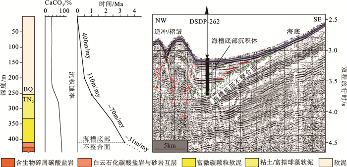
帝汶海槽是位于帝汶岛和澳大利亚西北大陆架之间的深海槽,槽底宽约5 km,水深2000~3500 m,底部沉积一个较厚楔形沉积体(厚度250~500 m),平行于底部亚平行沉积层,海槽底部沉积体与陆架斜坡沉积之间有一个明显的不整合面。DSDP-262井钻于西帝汶海槽南段,井深442 m,钻穿海槽底部沉积物,钻遇第四纪沉积体与晚上新世地层,自下而上分别为晚上新世碳酸盐岩和第四纪沉积,岩性可依次分为含生物碎屑碳酸盐岩层、白云石化碳酸盐岩与砂岩层、富微碳颗粒软泥层、含拟球藻浮游有孔虫软泥层、软泥层5个特征带(图 7)。DSDP-262经校正后的生物地层数据表明,海槽底部沉积体与陆架斜坡沉积之间的不整合面为晚上新世约3.3 Ma,由于DSDP-262底部岩心缺少能够确定年代的标志性化石,下部地层年龄无法准确界定,但岩心中未发现Globorotalia crassaformis有孔虫类[29],表明下部地层应晚于4 Ma。
DSDP-262钻井与帝汶海槽底部沉积体不整合面记录了晚上新世海槽由下伏陆架斜坡碳酸盐岩沉积到上覆半深海软泥沉积的急剧转变,海槽底部晚上新世碳酸盐岩表明该时期海槽为浅水环境,向上碳酸盐岩消失表明帝汶海槽逐渐加深,细粒物质的增多及沉积速率的急剧增加,表明可能有来自帝汶岛沿岸的新物质输入(图 7)。同期澳大利亚大陆边缘发生了弯曲变形,澳大利亚西北大陆架边缘台地经历了与岩石圈挠曲有关的断陷和拉张变形,断层落差与生长指数分析指示了断层活动的多个阶段。帝汶岛地层在约3 Ma记录了由碳酸盐岩沉积转变为浊积岩和岩屑沉积的变化[31],表明经历了一次隆升事件;浊积岩和泥灰岩层的孢粉学研究证明在约3.01 Ma帝汶岛迅速隆起[32]。帝汶岛的隆升导致早期帝汶海槽的沉降和波拿帕特盆地边缘隆起的变形,因此,结合最新物源研究,笔者认为帝汶海槽是一个早期的前陆盆地[33-35],而不是一个已停止的俯冲带。帝汶海槽北部碰撞产生的逆冲推覆与挤压作用,导致较薄的澳大利亚大陆地壳前缘变形,原始帝汶前缘随着弧-陆碰撞和向北逆冲开始变形,形成现今的帝汶海槽形态。帝汶岛构造古地理研究认为,海槽前缘在约5.7 Ma已形成于帝汶岛南侧[36],早期前缘由于逆冲作用变形,逐渐向克拉通方向移动,同造山期沉积物沉积在不断演化的前陆盆地和背驮式盆地内,形成了现代帝汶海槽,弧-陆碰撞后形成的弗洛勒斯-韦塔(Flores-Wetar)板块边界将外班达弧转变为双向扩张造山带。帝汶海槽的演化过程与中国台湾西部前陆盆地的发育和前缘隆起向克拉通方向的迁移具有相似性,二者在同时期的弧-陆碰撞背景下形成了相似的局部构造格局,但板块挠曲特性可能存在巨大差异[37-39]。
4.2 帝汶海槽演化模式
地震数据表明,帝汶海槽北侧是由一系列逆冲断层形成的造山楔与背驮式盆地,逆冲逐渐向南部前陆方向扩展,现今变形前锋位于海槽北侧斜坡底部。随着褶皱带和逆冲带的演化,背驮式盆地在各逆冲组合中向后发展,前陆盆地在逆冲前缘发展,早期逆冲前缘形成于现今位置北部,随前缘变形逐步向前陆移动。逆冲影响了早期帝汶海槽的沉积,海槽沉积物中保留了早期挤压变形的痕迹,现今海底断层的存在表明沉积速率低于断层活动,因此海槽可能还在继续横向变形中,沿澳大利亚西北边缘的弯曲变形、断层活动和逆冲前缘变形持续至今。东帝汶海槽沉积序列与断裂活动记录的变形时间同弧-陆碰撞时间一致,早中新世—晚中新世断层落差与生长指数增大,表明新几内亚岛与东南亚板块碰撞影响了东帝汶海槽的断层活动;晚中新世—晚上新世断层落差与生长指数达到最大,断层活动性达到顶峰,表明弧-陆碰撞引发了东帝汶海槽古老断层的再活化与新断层的发育;第四纪以来,断层落差与生长指数逐渐减小,表明弧-陆碰撞引发的构造活动逐渐趋于稳定,标志着碰撞的结束,但碰撞引发的构造变形可能仍在持续。晚中新世约6 Ma,澳大利亚大陆与班达岛弧的碰撞标志着澳大利亚西北边缘变形的开始,导致中生代卡地亚海槽的再次沉降及其边缘的隆升和伸展断层活动,由于北部班达岛弧的推力作用,帝汶岛开始隆升,帝汶海槽开始沉降。自此,澳大利亚板块与班达岛弧由洋-陆俯冲转变为陆-陆碰撞与挤压变形(图 8)。
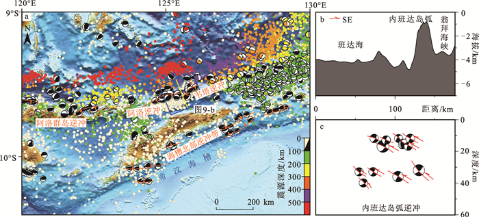
东帝汶海槽-班达岛弧区域天然地震事件分布(图 9-a)反映了现今澳大利亚板块的特征,帝汶海槽与澳大利亚西北陆架地震事件较少,主要分布于浅层,相比于帝汶岛、帝汶海槽所处的外班达弧,内班达弧深源地震与强震数量明显增多,震源最大深度超过600 km,最大震级超过7级,表明班达岛弧区域板块、构造活动较活跃。外班达岛弧以北的地震事件分布形态与班达岛弧一致,呈现出明显的分带性与规律性,自帝汶岛北部边缘起地震事件逐渐增多,向北震源深度逐渐加深,一直延伸至班达海内部。震源机制解表明,海槽北部发育一系列逆冲断层,与地震剖面特征一致;韦塔岛、阿洛群岛浅部(10~50 km)已产生新的逆冲(图 9-b),表明内班达岛弧正在沿班达海发生变形,深部澳大利亚洋壳可能已俯冲至班达海下方。
来自帝汶岛的物源、地质年代研究,帝汶海槽的构造特征与演化过程研究,以及区域内天然地震研究等都指示现今帝汶海槽属于板块变形前缘,而非俯冲带。澳大利亚板块与班达岛弧之间的俯冲带位于帝汶岛北部与韦塔岛之间的翁拜海峡,即内班达弧与外班达弧之间,第四纪以来,弧-陆碰撞结束后,澳大利亚板块与班达岛弧之间的相对运动速率逐渐减小,但并不代表现今澳大利亚板块与欧亚板块之间的运动、俯冲、变形已经停止。现今,内、外班达岛弧之间的相对运动速率约为22 mm/a[40],韦塔岛与阿洛群岛北部的新逆冲表明,二者可能作为一个整体继续向北运动,这为预测板块间发展趋势与地质灾害研究提供了新的见解与认识。
5. 结论
(1) 东帝汶海槽北部主要发育一系列褶皱、叠瓦状逆冲断层,南部陆架以大量发育SW—NE向正断层为主要特征,海槽南部陆架断裂活动特征表现为早白垩世之前裂谷与裂后沉降期和新近纪以来弧-陆碰撞期2个活动高峰。弧-陆碰撞导致帝汶岛隆升与帝汶海槽的沉降并引发古老断裂再活化,活动高峰出现于约6 Ma,约3 Ma之后,断裂活动性下降并趋于稳定。
(2) 东帝汶海槽F3、F6一级断裂主要控制了帝汶海槽的沉降与澳大利亚西北陆架边界,F4、F5、F7、F8二级断裂主要控制了地垒、地堑特征,F1、F2三级断裂主要控制了次级凹陷特征。依据断层分析与构造演化过程,东帝汶海槽新近纪以来断裂活动分为早中新世—晚中新世断裂活动性上升阶段、晚中新世—晚上新世断裂活动高峰、第四纪断裂活动性下降3个阶段。
(3) 晚中新世约6 Ma澳大利亚大陆边缘帝汶岛与东南亚班达岛弧发生碰撞,导致帝汶岛隆升与早期帝汶海槽前缘变形,晚上新世3.3~3 Ma在班达岛弧的挤压作用下,帝汶前缘受北侧隆升与挤压作用,沿底部凹陷向下变形形成现今帝汶海槽形态。晚中新世—晚上新世的弧-陆碰撞使澳大利亚板块与班达岛弧由洋-陆俯冲转变为陆-陆碰撞与挤压变形,内班达弧北部韦塔-阿洛逆冲的产生表明未来二者可能以一个整体继续向北运动。
致谢: 感谢审稿专家对本文提出的宝贵修改意见和进一步深入研究的建议,使本文内容更加严谨、完善。 -
图 1 东帝汶海槽位置(a)与区域构造图(b)
(据参考文献[5]修改)
Figure 1. Location(a) and regional structure(b) of the East Timor trough
图 2 东帝汶海槽地层柱状图与构造事件
(据参考文献[23]修改)
Figure 2. Stratigraphy of the East Timor trough and its tectonic events
-
Mccaffrey R. Active tectonics of the Eastern Sunda and Banda Arcs[J]. Journal of Geophysical Research: Solid Earth, 1988, 93(B12): 15163-15182. doi: 10.1029/JB093iB12p15163
Obrien G W, Lisk M, Duddy I R, et al. Plate convergence, foreland development and fault reactivation: Primary controls on brine migration, thermal histories and trap breach in the Timor Sea, Australia[J]. Marine & Petroleum Geology, 1999, 16(6): 533-560.
Tandon K, Lorenzo J M, O'Brien G W. Effective elastic thickness of the northern Australian continental lithosphere subducting beneath the Banda orogen(Indonesia): inelastic failure at the start of continental subduction[J]. Tectonophysics, 2000, 329: 39-60. doi: 10.1016/S0040-1951(00)00187-6
Harrowfield M, Cunneen J, Keep M, et al. Early-stage orogenesis in the Timor Sea region, NW Australia[J]. Journal of the Geological Society, 2003, 160(6): 991-1001. doi: 10.1144/0016-764903-020
Audley-Charles M G. Ocean trench blocked and obliterated by Banda forearc collision with Australian proximal continental slope[J]. Tectonophysics, 2004, 389: 65-79. doi: 10.1016/j.tecto.2004.07.048
Hall R. Cenozoic geological and plate tectonic evolution of SE Asia and the SW Pacific: computer-based reconstructions, model and animations[J]. Journal of Asian Earth Sciences, 2002, 20(4): 353-431. doi: 10.1016/S1367-9120(01)00069-4
Keep M, Haig D W. Deformation and exhumation in Timor: Distinct stages of a young orogeny[J]. Tectonophysics, 2010, 483: 93-111. doi: 10.1016/j.tecto.2009.11.018
Tate G W, McQuarrie N, van Hinsbergen D J J, et al. Australia going down under: Quantifying continental subduction during arc-continent accretion in Timor-Leste[J]. Geosphere, 2015, 11(6): 1-24.
Hall R. Southeast Asia: New Views of the Geology of the Malay Archipelago[J]. Annual Review of Earth and Planetary Sciences, 2017, 45(1): 331-358. doi: 10.1146/annurev-earth-063016-020633
Baillie P, Gregor D, Christian M. Geological Development of the Western End of the Timor Trough[C]//SEAPEX. Proceedings of the 2013 South East Asia Petroleum Exploration Society Conference. Singapore: Southeast Asia Petroleum Exploration Society, 2016: 1-46.
Etheridge M A, O'Brien G W. Structural and tectonic evolution of the Western Australian margin basin system[J]. Journal of the Petroleum Exploration Society of Australia, 1994, 22: 45-64.
Brown D, Ryan P D, Afonso J C, et al. Arc-Continent Collision: The making of an Orogen[C]//Burn J P. Arc-Continent Collision: Frontiers in Earth Sciences. Berlin: Springer-Verlag, 2011: 477-493.
Metcalfe I. Tectonic framework and Phanerozoic evolution of Sundaland[J]. Gondwana Research, 2011, 19(1): 3-21. doi: 10.1016/j.gr.2010.02.016
Hall R, Wilson M. Neogene sutures in eastern Indonesia[J]. Journal of Asian Earth Sciences, 2000, 18(1): 781-808. http://www.sciencedirect.com/science/article/pii/S1367912000000407
Kearey P, Klepeis K A, Vine F J. Continental rifts and rifted margins[C]//John Wiley & Sons. Global Tectonics. Hoboken: Wiley-Blackwell, 2009: 176-204.
Londono J, Lorenzo J M. Geodynamics of continental plate collision during late tertiary foreland basin evolution in the Timor Sea: constraints from foreland sequences, elastic flexure and normal faulting[J]. Tectonophysics, 2004, 392: 37-54. doi: 10.1016/j.tecto.2004.04.007
Haig D W, McCartain E. Carbonate pelagites in the post-Gondwana succession(Cretaceous-Neogene)of East Timor[J]. Australian Journal of Earth Sciences, 2007, 54(6): 875-897. doi: 10.1080/08120090701392739
O'Brien G W, Higgins R, Symonds P, et al. Basement control on the development of extensional systems in Australia's Timor Sea: an example of hybrid hard linked/soft linkedfaulting?[J]. The APPEA Journal, 1996, 36(Pt1): 161-201.
Shuster M W, Eaton S, Wakefield L L, et al. Neogene tectonics, greater Timor Sea, offshore Australia: implications for trap risk[J]. The APPEA Journal, 1998, 38(1): 351-379. doi: 10.1071/AJ97017
Zimmermann S, Hall R. Provenance of Cretaceous sandstones in the Banda Arc and their tectonic significance[J]. Gondwana Research, 2019, 67: 1-20. doi: 10.1016/j.gr.2018.09.008
杨献忠, 曾勇, 刘君安, 等. 东帝汶国金属矿产资源潜力与矿业投资环境[J]. 地质通报, 2014, 33(2/3): 334-341. http://dzhtb.cgs.cn/gbc/ch/reader/view_abstract.aspx?file_no=2014020319&flag=1 Zimmermann S, Hall R. Provenance of Triassic and Jurassic sandstones in the Banda Arc: Petrography, heavy minerals and zircon geochronology[J]. Gondwana Research, 2016, 37: 1-19. doi: 10.1016/j.gr.2016.06.001
Keep M, Harrowfield M, Crowe W. The Neogene tectonic history of the North West Shelf, Australia[J]. Exploration Geophysics, 2007, 38(3): 151-174. doi: 10.1071/EG07022
冉伟民, 栾锡武, 邵珠福, 等. 东海陆架盆地南部生长断层活动特征[J]. 海洋地质与第四纪地质, 2019, 39(1): 100-112. https://www.cnki.com.cn/Article/CJFDTOTAL-HYDZ201901011.htm 雷宝华. 生长断层活动强度定量研究的主要方法评述[J]. 地球科学进展, 2012, 27(9): 947-956. https://www.cnki.com.cn/Article/CJFDTOTAL-DXJZ201209005.htm 张豪, 栾锡武, 冉伟民, 等. 珠江口盆地西部文昌A凹陷断裂特征与成因探讨[J]. 海洋地质与第四纪地质, 2020, 40(4): 96-106. https://www.cnki.com.cn/Article/CJFDTOTAL-HYDZ202004008.htm Keep M, Harrowfield M. Elastic flexure and distributed deformation along Australia's North West Shelf: Neogene tectonics of the Bonaparte and Browse basins[J]. Geological Society London Special Publications, 2015, 306(1): 185-200.
Hall R, Cottam M A, Wilson M E J. The SE Asian gateway: history and tectonics of the Australia-Asia collision[J]. Geological Society London Special Publications, 2011, 355(1): 1-6. doi: 10.1144/SP355.1
Saqab M M, Bourget J, Trotter J, et al. New constraints on the timing of flexural deformation along the northern Australian margin: Implications for arc-continent collision and the development of the Timor Trough[J]. Tectonophysics, 2017, 696: 14-36.
James R H, John J V, Hans M B, et al. Deep Sea Drilling Program Site 262 report[M]. Woods Hole: Deep Sea Drilling Project, 1972: 193-210.
Frankowicz E, McClay K R. Extensional fault segmentation and linkages, Bonaparte Basin, outer North West Shelf, Australia[J]. AAPG Bulletin, 2010, 94(7): 977-1010. doi: 10.1306/01051009120
Nguyen N, Duffy B, Shulmeister J, et al. Rapid Pliocene uplift of Timor[J]. Geology, 2013, 41(2): 179-182. doi: 10.1130/G33420.1
Spakman W, Hall R. Surface deformation and slab-mantle interaction during Banda arc subduction rollback[J]. Nature Geoscience, 2010, 3(8): 562-566. doi: 10.1038/ngeo917
Audley-Charles M G. Rates of Neogene and Quaternary tectonic movements in the Southern Banda Arc based onmicropalaeontology[J]. Journal of the Geological Society, 1986, 143(1): 161-175. doi: 10.1144/gsjgs.143.1.0161
Hall R. Late Jurassic-Cenozoic reconstructions of the Indonesian region and the Indian Ocean[J]. Tectonophysics, 2012, 570/571: 1-41. doi: 10.1016/j.tecto.2012.04.021
Haig D W. Palaeobathymetric gradients across Timor during 5.7-3.3 Ma(latest Miocene-Pliocene)and implications for collision uplift[J]. Palaeogeography, Palaeoclimatology, Palaeoecology, 2012, 331/332: 50-59. doi: 10.1016/j.palaeo.2012.02.032
Huang C Y, Yuan P B, Lin C W, et al. Geodynamic processes of Taiwan arc-continent collision and comparison with analogs in Timor, Papua New Guinea, Urals and Corsica[J]. Tectonophysics, 2000, 325: 1-21. doi: 10.1016/S0040-1951(00)00128-1
王海荣, 王英民, 刘振湖, 等. 台湾西部前陆盆地和帝汶海前陆盆地的比较学研究[J]. 大地构造与成矿学, 2007, 31(2): 137-144. doi: 10.3969/j.issn.1001-1552.2007.02.001 Chang J, Yu H, Hsu H, et al. Forebulge migration in late Cenozoic western Taiwan foreland basin[J]. Tectonophysics, 2012, 578: 117-125. doi: 10.1016/j.tecto.2011.09.007
Nugroho H, Harris R, Lestariya A W, et al. Plate boundary reorganization in the active Banda Arc-continent collision: Insights from new GPS measurements[J]. Tectonophysics, 2009, 479: 52-65. doi: 10.1016/j.tecto.2009.01.026
-
期刊类型引用(4)
1. 栾锡武. 东南亚构造分区. 地球科学进展. 2022(03): 221-252 .  百度学术
百度学术
2. 何明勇,栾锡武,魏新元,冉伟民,穆敬轩,叶传红,刘洁,陈建宏. 塔宁巴尔海槽断裂特征与构造演化. 地球科学进展. 2022(03): 290-302 .  百度学术
百度学术
3. 魏新元,栾锡武,孟凡顺,冉伟民,鲁银涛,刘泽璇,王嘉,胡庆,张丹丹. 帝汶海槽构造与地震特征对深部板块的约束. 地球科学进展. 2022(03): 277-289 .  百度学术
百度学术
4. 代向明,李志刚,孙闯,李立国,王伟涛,惠格格,梁浩,张逸鹏,李琳琳,闫永刚,许斌斌,李冠华. 正断层三维生长和连接过程研究:以南海北部陆丰凹陷为例. 地质学报. 2022(06): 1922-1936 .  百度学术
百度学术
其他类型引用(2)


 下载:
下载:
