
Intelligent extraction of area element information from colored geological map on the basis of BP neural network and mathematical morphology
-
摘要:
地质图是一个区域地质研究的重要成果,也是前人留下的宝贵资料,更融合了地质专家的丰富知识。本研究的目的是通过新的思路将彩色地质图信息提取出来,使其结果能直接进行数据分析,并用于决策和分析。以机器学习为指导,在分析半结构化(栅格)地质图特征的基础上,根据图例信息,提出一种彩色地质图信息提取新思路,对彩色地质图进行分层信息提取,并结合数学形态学和多层前向反馈式神经网络,探索半结构化数据转换为结构数据的有效技术方法。利用图像信息提取技术将半结构化地质图转化为结构化数据,可用于成矿预测等研究。这一变化将改变传统地质数据的结构,地质研究的信息基础和来源将会增加,对于获取更多的数据源和信息源,进一步开展地质分析研究具有重要意义。
Abstract:As an important result of regional geological research geological map not only belongs to the valuable information left by the previous researchers but also integrates the rich knowledgeof geological experts.The purpose of this study is to extract the color geological map information through new ideas, so that the results can be directly used for data analysis and used for decision-making and analysis. Guided by machine learning and based on the analysis of the characteristics of semi-structured grid geological maps this paper proposes a new idea for extracting the information of colored geological map according to the legend information and exploring the effective technology method for transforming semi-structured data into structured data in combination with mathematical morphology and multilayer feed forward neural network. Therefore the semi-structured geological map can be transformed into structured data available for metallogenic prediction and other researches with the help of image information extraction technology.This innovation will change the structure of traditional geological data and increase the information base and source for geological research therefore it is of important significance to obtain more data sources and information sources and to further carry out geological analysis and research.
-
-
![]()
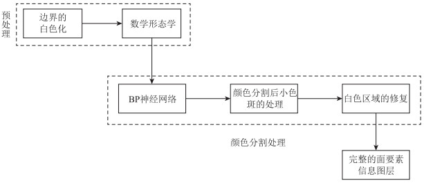
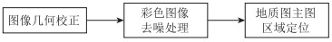
图 1 半结构化地质图图像预处理流程图
Figure 1. Flow chart for the image preprocessing of semi-structured geological map
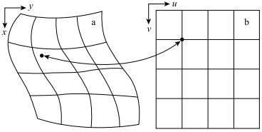
![]()
图 2 图像几何校正示意图
a—校正前;b—校正后
Figure 2. Schematic diagram for the geometric correction of image
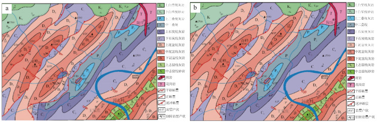
![]()
图 3 金山镇地质图的几何校正
a—几何校正前的地质图;b—几何校正后的地质图
Figure 3. Geometric correction of geological map in Jinshan Town
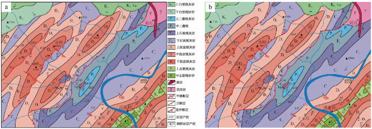
![]()
图 4 金山镇地质图主图区域的定位
a—原图;b—主图区域
Figure 4. Localization of the main map area of geological map in Jinshan Town
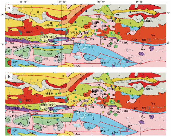
![]()
图 5 冈底斯中南段地质图主图区域的定位
a—原图;b—主图区域
Figure 5. Localization of the main map area of geological map in middle-south segment of Gangdise
![]()
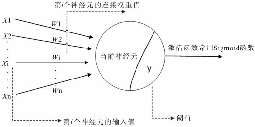
图 10 具有Sigmoid函数阈限的典型神经元节点
Figure 10. Typical neuron nodes with Sigmoid function threshold
-
赵鹏大, 张寿庭, 陈建平.危机矿山可接替资源预测评价若干问题探讨[J].成都理工大学学报(自然科学版), 2004, 31(2):111-117. http://www.wanfangdata.com.cn/details/detail.do?_type=perio&id=cdlgxyxb200402001 赵鹏大, 陈建平.非传统矿产资源体系及其关键科学问题[J].地球科学进展, 2000, 15(3):251-255. http://www.wanfangdata.com.cn/details/detail.do?_type=perio&id=dqkxjz200003002 陈建平, 李婧, 崔宁, 等.大数据背景下地质云的构建与应用[J].地质通报, 2015, 34(7):1260-1265. http://www.wanfangdata.com.cn/details/detail.do?_type=perio&id=zgqydz201507002 李华蓉.基于图段的彩色地图线要素智能识别[D].武汉大学博士学位论文, 2010. Shi L, Jianping C, Jie X.Prospecting Information Extraction by Text Mining Based on Convolutional Neural Networks - A case study of the Lala Copper Deposit, China[J].IEEE Access, 2018:1-1.
章毓晋.图像工程(上册):图像处理和分析[M].北京:清华大学出版社, 1999. 朱述龙, 朱宝山, 王卫红.遥感图像处理与应用[M].北京:科学出版社, 2006. Gonzalez R C, Woods R E.Digital image processing[M].Beijing:Publishing House of Electronics Industry, 2002.
Fabijanska A, Sankowski D.Noise adaptive switching median-base filter for impulse noise removal from extremely corrupted images[J].Image Processing, 2011, 5(5):472-480. https://www.researchgate.net/publication/224250222_Noise_adaptive_switching_median-based_filter_for_impulse_noise_removal_from_extremely_corrupted_images
苟中魁, 张少军, 李忠富, 等.一种基于极值的自适应中值滤波算法[J].红外与激光, 2005, 34(1):98-101. http://www.cnki.com.cn/Article/CJFDTotal-HWYJ200501023.htm 陈盛双, 陆昊娟, 李亮, 等.彩色图像去噪方法的研究[J].武汉理工大学学报(信息与管理工程版), 2001, 32(1):10-12. http://www.wanfangdata.com.cn/details/detail.do?_type=perio&id=whqcgydxxb200101004 盛宜韬.地形图矢量化设计及在三维重建中的应用[D].华南理工大学硕士学位论文, 2010. 卢敏.土地利用基础图件矢量化关键技术研究[D].华中科技大学硕士学位论文, 2007. Huttonlocher D P, Klanderman G A, Ruchlidge W J.Cmparing Image using the Hausdorff distance.IEEE Tran[J].Pattern Analysis and Machine Intelligence, 1993, 15(9):850-863.
Serra J.Image analysis and mathematical morphology[M].London:Academic Press, 1982.
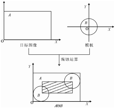
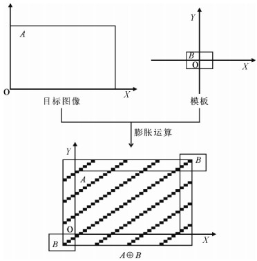
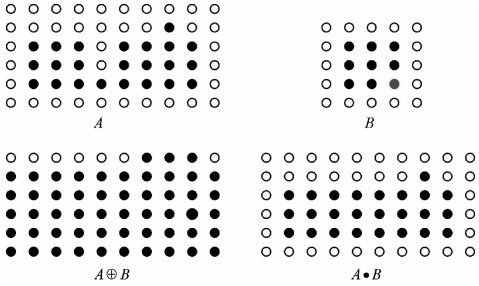
董保根.遥感影像上目标提取的数学形态学方法研究[D].解放军信息工程大学硕士学位论文, 2005. 熊联欢, 胡汉平, 李德华, 等.用BP网络进行彩色图像分割和边缘检测[J].华中理工大学学报, 1999, 27(2):87-89. http://www.wanfangdata.com.cn/details/detail.do?_type=perio&id=hzlgdxxb199902030 杨治明, 王晓蓉, 彭军, 等.BP人工神经网络在图像分割中的应用[J].计算机科学, 2007, 34(3):234-236. http://www.wanfangdata.com.cn/details/detail.do?_type=perio&id=jsjkx200703063
 下载:
下载:
计量
- 文章访问数: 2731
- HTML全文浏览量: 440
- PDF下载量: 1648
