Contrast application of unmanned aerial vehicle remote sensing and satellite remote sensing technology relating to ground surface cracks recognition in coal mining area
-
摘要:
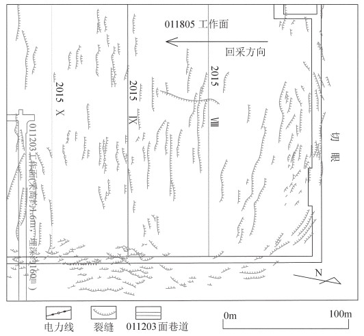
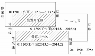
采煤诱发地表裂缝是地面塌陷最直观的表现形式之一,也是造成煤矿区环境恶化的主要因素。准确掌握地表裂缝的展布规律是煤矿区地面塌陷治理的基础。以宁夏金凤煤矿011805工作面为研究对象,对比分析卫星遥感影像与无人机遥感影像在地表裂缝调查、解译识别中的优缺点,总结工作面地表裂缝发育规律。研究表明,无人机航拍影像中裂缝整体视觉清晰,可充分反映出宽度大于5cm的地表裂缝的形态、长度、位置等发育特征,且解译出的地表裂缝发育规律更接近实际;无人机遥感不仅提高了煤矿区地表裂缝调查的精度和可靠性,也为地表裂缝各项研究提供了丰富的基础数据。
Abstract:The surface cracks induced by coal mining constitute one of the most intuitive manifestations of ground collapse and also the main factor causing the environmental deterioration in the coal mine. Thus accurately grasping the distribution law of surface cracks is the basis for the treatment of ground subsidence in the coal mine. In this paper, satellite remote sensing and unmanned aerial vehicle remote sensing technology were used to investigate the distribution of surface cracks of the 011805 working face which was selected as the research area. Research shows that in the aerial images of UAVs, the overall vision of ground cracks is clear, which can fully reflect the development characteristics including the shape, length, and location of ground cracks with a width greater than 5cm. and the interpretation results of the ground cracks are closest to reality. UAV remote sensing not only improves the accuracy and reliability of the surface crack investigation in the coal mining area but also provides abundant basic data for the study of the surface cracks.
-
致谢: 地表裂缝的野外调查工作由金凤煤矿地测科工作人员协助完成,在此表示衷心的感谢。
-
表 1 遥感影像数据
Table 1 Remote sensing image data
影像类型 分辨率/m 拍摄装备 拍摄时间 卫星遥感影像(全色波段) 0.5 Geoeye卫星 2016.12 无人机航拍影像 0.04 索尼A7R数码相机 2017.3 -
贺卫中, 向茂西, 刘海南, 等.榆神府地面塌陷特征及环境问题[J].煤田地质与勘探, 2016, 44(5):131-135. doi: 10.3969/j.issn.1001-1986.2016.05.025 蔡怀恩.彬长矿区地面塌陷特征及形成机理研究[D].西安科技大学硕士学位论文, 2008. http://cdmd.cnki.com.cn/Article/CDMD-10704-2008145586.htm 赵坤阳.煤矿地下开采诱发地表裂缝与导水裂缝分布规律预测[D].中国地质大学(北京)硕士学位论文, 2015. http://cdmd.cnki.com.cn/Article/CDMD-11415-1015391331.htm 胡振琪, 王新静, 贺安民.风积沙区采煤沉陷地裂缝分布特征及发生发育规律[J].煤炭学报, 2014, 39(1):11-18. http://cdmd.cnki.com.cn/Article/CDMD-11413-1014371351.htm 胡青峰, 崔希民, 袁德宝, 等.厚煤层开采地表裂缝形成机理与危害性分析[J].采矿与安全工程学报, 2012, 29(6):864-869. http://d.old.wanfangdata.com.cn/Periodical/ksylydbgl201206019 王瑞国.基于WorldView-2数据的乌东煤矿地质灾害遥感调查及成因分析[J].国土资源遥感, 2016, 28(2):132-138. http://d.old.wanfangdata.com.cn/Periodical/gtzyyg201602022 侯恩科, 首召贵, 徐友宁, 等.无人机遥感技术在采煤地面塌陷监测中的应用[J].煤田地质与勘探, 2017, 45(6):102-110. doi: 10.3969/j.issn.1001-1986.2017.06.017 张启元.无人机航测技术在青藏高原地质灾害调查中的应用[J].青海大学学报, 2015, (2):67-72. http://d.old.wanfangdata.com.cn/Periodical/qhdxxb-zr201502012 谢晓深, 侯恩科, 高冠杰, 等.宁夏羊场湾煤矿浅埋煤层开采地面塌陷发育规律及形成机理[J].地质通报, 2018, 37(12):2233-2240. http://dzhtb.cgs.cn/gbc/ch/reader/view_abstract.aspx?file_no=20181214&flag=1 邓喀中, 王刘宇, 范洪冬.基于InSAR技术的老采空区地表沉降监测与分析[J].采矿与安全工程学报, 2015, 32(6):918-922. http://d.old.wanfangdata.com.cn/Periodical/ksylydbgl201506008 张舒, 吴侃, 王响雷, 等.三维激光扫描技术在沉陷监测中的应用问题探讨[J].煤炭科学技术, 2008, 36(11):91-95. http://www.wanfangdata.com.cn/details/detail.do?_type=perio&id=6683076 -
期刊类型引用(34)
1. 侯恩科,慕佳欣,谢晓深,冯栋,杨磊,李研,何涛,包康光,陈小绳. 浅埋煤层开采地表裂缝发育规律及形成演化机理. 煤田地质与勘探. 2025(02): 107-117 .  百度学术
百度学术
2. 苏宇,汤伏全,李景祥,王聪,张馨月. 矿山采动地表裂缝智能识别的YOLOv7模型改进研究. 煤矿安全. 2024(04): 169-176 .  百度学术
百度学术
3. 李涛,王帆,胡东升,廉旭刚. 无人机低空遥感裂缝识别与采动地表变形指标的相关性研究. 金属矿山. 2024(07): 159-167 .  百度学术
百度学术
4. 陈柯,RUHIZAL Bin Roosli,赵国梁,陈向阳,张丞韫,冯羽. 儿童友好导向的矿区地表致灾因素治理规划研究与探索:以硕嘉湾矿区为例. 中国矿业. 2024(07): 99-107 .  百度学术
百度学术
5. 谢晓深,侯恩科,冯栋,从通,侯鹏飞,陈秋计,王建文,李民峰,谢永利. 榆神府矿区采煤地表裂缝发育规律及特征. 工程科学学报. 2023(01): 44-53 .  百度学术
百度学术
6. 廉旭刚,韩雨,刘晓宇,胡海峰,蔡音飞. 无人机低空遥感矿山地质灾害监测研究进展及发展趋势. 金属矿山. 2023(01): 17-29 .  百度学术
百度学术
7. 刘星,莫思特,张江,王炜康,杨世基,李鑫. 轻量化模型的PeleeNet_yolov3地表裂缝识别. 哈尔滨工业大学学报. 2023(04): 81-89 .  百度学术
百度学术
8. 袁新悦,甘淑,高莎,胡琳,毕瑞,罗为东. 免像控无人机技术在矿山地貌形态调查中的应用. 地质通报. 2023(Z1): 479-487 .  本站查看
本站查看
9. 张建国,鲁佳,蔡厚安,张远飞. 高光谱遥感技术在大冶地区水环境监测中的应用. 矿产勘查. 2023(03): 471-479 .  百度学术
百度学术
10. 陈芳,李杰卫,张琰君,朱贵祯,朱元昊,朱宏,朱文鑫. 黄土沟壑区特厚煤层开采地裂缝发育规律研究. 金属矿山. 2023(04): 229-235 .  百度学术
百度学术
11. 杨奇让,胡振琪,韩佳政,杨坤,浮耀坤. 煤矿区无人机影像采动地裂缝提取方法研究. 煤炭科学技术. 2023(06): 187-196 .  百度学术
百度学术
12. 员鸿燕,潘峰,吴年华,蒙君文. 基于无人机的矿区采动裂缝遥感解译方法研究与应用. 山西煤炭. 2023(02): 103-108 .  百度学术
百度学术
13. 于航,安娜,汪洁,邢宇,许文佳,步凡,王晓红,杨金中. 黔西南采煤塌陷区高分遥感动态监测——以六盘水市煤矿采空塌陷区为例. 自然资源遥感. 2023(03): 310-318 .  百度学术
百度学术
14. 李斯,杨自安,李冬月,张建国,鲁佳,尹展. 基于无人机倾斜摄影三维建模技术的赤马山铜矿地质环境调查及评价. 地质与勘探. 2023(06): 1271-1281 .  百度学术
百度学术
15. 汤伏全,杨倩. 西部黄土高原矿区采煤沉陷多源遥感监测技术进展与展望. 煤炭科学技术. 2023(12): 9-26 .  百度学术
百度学术
16. 赵毅鑫,许多,张康宁,令春伟,陶亚飞,郭晓冬,孙波. 采动地表浅层隐蔽裂缝的无人机红外识别现场试验. 煤炭学报. 2022(05): 1921-1932 .  百度学术
百度学术
17. 杨创,李聪聪,万余庆. 遥感技术在煤矿山环境监测评价中的应用. 中国煤炭地质. 2022(07): 61-66 .  百度学术
百度学术
18. 周大伟,安士凯,吴侃,胡振琪,刁鑫鹏. 矿山开采损害InSAR/UAV融合监测关键技术及应用. 煤炭科学技术. 2022(10): 121-134 .  百度学术
百度学术
19. 李洋. 羊场湾煤矿130201工作面地表沉陷规律研究. 煤炭技术. 2022(12): 97-100 .  百度学术
百度学术
20. 侯恩科,谢晓深,冯栋,陈秋计,车晓阳,侯鹏飞. 浅埋煤层开采地面塌陷裂缝规律及防治方法. 煤田地质与勘探. 2022(12): 30-40 .  百度学术
百度学术
21. 范立民,吴群英,彭捷,迟宝锁,孙魁,王宏科,郭佐宁,宁奎斌,刘水,李成,赵小峰,田水豹,李博,陈建平,高帅,仵拨云,姬怡微,郑苗苗,杜江丽. 黄河中游大型煤炭基地地质环境监测思路和方法. 煤炭学报. 2021(05): 1417-1427 .  百度学术
百度学术
22. 秦臻,黄波林,张鹏. 基于探地雷达检测的岩溶岸坡内部宏观裂隙响应规律研究. 工程地质学报. 2021(03): 628-639 .  百度学术
百度学术
23. 杜江. 煤矿工作中地表裂缝的成因与防治. 当代化工研究. 2021(18): 101-102 .  百度学术
百度学术
24. 牛晓楠,倪欢,李云峰,张庆,周小平,陆远志,郝娇娇. 基于遥感影像变化检测的城区暗浜自动识别方法——以安庆市为例. 地质通报. 2021(10): 1697-1706 .  本站查看
本站查看
25. 侯恩科,谢晓深,王双明,从通,冯栋,陈真. 中埋深煤层综采地表裂缝发育规律研究. 采矿与安全工程学报. 2021(06): 1178-1188 .  百度学术
百度学术
26. 谢晓深,侯恩科,王双明,刘峰,谢永利,陈真,马越,白坤. 风沙滩地区中深埋厚煤层综采地表移动变形规律实测研究. 煤矿安全. 2021(12): 199-206 .  百度学术
百度学术
27. 龙林丽,刘英,张旭阳,苏永东,陈孝杨. 无人机在矿区表土特征及地质灾害监测中的应用. 煤田地质与勘探. 2021(06): 200-211 .  百度学术
百度学术
28. 汤伏全,李林宽,李小涛,刘世伟. 基于无人机影像的采动地表裂缝特征研究. 煤炭科学技术. 2020(10): 130-136 .  百度学术
百度学术
29. 戴华阳,罗景程,郭俊廷,阎跃观,张旺,朱元昊. 上湾矿高强度开采地表裂缝发育规律实测研究. 煤炭科学技术. 2020(10): 124-129 .  百度学术
百度学术
30. LIAN Xu-gang,LI Zou-jun,YUAN Hong-yan,LIU Ji-bo,ZHANG Yan-jun,LIU Xiao-yu,WU Yan-ru. Rapid identification of landslide, collapse and crack based on low-altitude remote sensing image of UAV. Journal of Mountain Science. 2020(12): 2915-2928 .  必应学术
必应学术
31. 杨豪杰,张锦. 矿区采动地裂缝高分辨率影像特征分析. 地理信息世界. 2020(06): 57-63 .  百度学术
百度学术
32. 程健,叶亮,郭一楠,王瑞彬. 采空区地裂缝混合域注意力变形卷积网络检测方法. 煤炭学报. 2020(S2): 993-1002 .  百度学术
百度学术
33. 丁俊,马宁,谢一晖. 湖南省废弃煤矿地面沉陷监测的遥感技术应用探讨. 中国矿业. 2019(S2): 236-239 .  百度学术
百度学术
34. 黄海宁,黄健,周春宏,潘勇杰. 无人机影像在高陡边坡危岩体调查中的应用. 水文地质工程地质. 2019(06): 149-155 .  百度学术
百度学术
其他类型引用(18)


 下载:
下载:
