
Paleomagnetic study of Pliocene lacustrine strata in the Baoshan Basin at the southeastern edge of the Tibetan Plateau
-
摘要:
青藏高原东南缘受印度板块的持续挤压发生了强烈的陆内变形,前人的研究结果显示,保山地体中新世以来发生强烈的旋转变形,因此,在保山盆地东南缘上新世湖相沉积地层中采集了30个采点(约300块定向样品),其中160块样品分离出了特征剩磁分量,通过了褶皱检验和倒转检验,代表了沉积地层形成时的原生剩磁分量。地层产状校正后剩磁平均方向为:Ds/Is=20.2°/37.1°,Ks=59.7,α95=4.8°,N=16;对应古地磁极为:北纬67.9 °、东经205.7°,A95=2.6。通过与保山盆地东缘科研钻井磁性地层结果进行对比,可以确定羊邑剖面年代为6±0.2Ma;与10Ma东亚构造稳定区古地磁参考极对比发现,保山盆地发生了19.2°±6°的顺时针旋转,表明保山地体上新世以来平均顺时针旋转速率为3.2°±1.0°/Ma,如此快速的旋转速率印证了保山地体和腾冲地块古近纪和中新世古地磁研究所揭示的大角度顺时针旋转变形量。
Abstract:The southeastern part of the Tibetan Plateau has been strongly deformed by the penetration of the Indian Plate since the early Cenozoic. A large clockwise rotation of the Baoshan Terrane was reported through previous paleomagnetic studies. The authors therefore carried out a paleomagnetic study of the Pliocene lacustrine strata in the Baoshan Basin. A total of about 160 samples were treated by thermal demagnetization, and the characteristic remanent magnetism components (ChRMs) were isolated from these sam-ples along the Yangyi section (YYN), southeastern part of Baoshan Basin. Site-mean direction from the YYN is Ds/Is=20.21°/37.1°, Ks=59.7, α95=4.8°, N=16 after tilt correction, which give a paleomagnetic pole at 67.9°N, 205.7°E, A95=2.6°. The ChRM directions of the YYN section pass the fold and reversal tests, indicating that it represents the primary remanent magnetization during the formation of sedimentary rocks. The results reveal that the Baoshan Terrane has suffered from a clockwise rotation about 19.2°±6° relative to the paleomagnetic reference pole of East Asia since the Pliocene. Based on a comparison with the magnetostratigraphic results of the drilled core on the east margin of Baoshan basin, the authors hold that the age of the sampled strata of the YYN section is 6±0.2Ma, and a mean rotating rate of the Baoshan basin is about 3.2°±1.0°/Ma. This result is consistent with the large clockwise rotation of the Baoshan basin since the Miocene revealed by Oligocene and Miocene paleomagnetic studies of the Baoshan Terrane and Tengchong Block.
-
Keywords:
- southeastern Tibetan Plateau /
- Baoshan Terrane /
- paleomagnetism /
- Pliocene /
- rotation
-
沙麦钨矿床位于内蒙古锡林郭勒盟东乌旗沙麦苏木,大地构造位置为贺根山断裂带以北的兴蒙造山系二连-东乌旗弧盆带[1-2],属大兴安岭成矿省二连-东乌旗铜-钼-铅-锌-钨-锡-铬-铁成矿带奥尤特-朝不愣-阿尔山铁-铜-铅-锌-银-钼多金属矿成矿亚带[3-4]。矿区内主要出露中细粒黑云母花岗岩,仅在矿区南东部零星出露中下侏罗统,大部分被第四系覆盖,据钻孔资料,深部见有泥盆系。晚期脉岩有花岗伟晶岩、花岗细晶岩等。矿区可见NW、NE两组交叉断裂,其中NW向断裂与矿化关系密切,沿断裂一般充填有脉岩、石英脉及云英岩、含钨石英脉等。沙麦钨矿是华北地区最大的脉型黑钨矿床,钨矿化与燕山晚期花岗岩体演化晚期边缘相的中粒似斑状黑云母花岗岩关系密切,矿体受控于矿区内由花岗岩节理发育而来的NW向张扭性断裂。前人对该矿区的地质勘查和科学研究积累了较多资料[5-7]①,但缺乏精确的成矿年龄资料。为此,本文采用Sm-Nd同位素法对黑钨矿进行了定年,采用TIMS锆石U-Pb法对黑云母花岗岩进行了定年,以精确厘定其成矿年龄。
1. 矿床地质特征
沙麦钨矿体为含黑钨矿石英脉,集中分布在东乌旗乌苏达因乌拉一带。共圈定钨矿体550余条,其中具工业品位的矿体有77条,呈平行排列,方向120°,长几米到数百米,宽数米到几厘米。矿体总体分布形态复杂,但具体矿脉形态较简单,呈石英大脉型和云英岩细脉型。规模较大,含矿较好的有3条脉带(图 1),其中1号矿脉带由24个脉体组成,矿脉带控制长约800m,深约400m,宽度30~130m。代表性矿脉为1-1、1-2、1-17、1-24。矿脉具右向斜列的特点。1-1含钨石英大脉分布于矿区中部,矿脉长约645m,平均厚度1.58m,最大倾斜延深约265m。总体走向NW305°,倾向SW,倾角84°~87°。矿体呈脉状产出,总体形态呈舒缓波状弱折线形,自然延伸尖灭,矿脉厚度变化不大,地表厚度变化系数为37%,沿脉坑道厚度变化系数为36%。平均品位2.75%。矿脉局部地段具有分支复合现象,分支细脉一般长30~90m,与主矿体呈锐角相交。石英脉型黑钨矿矿石的主要成分为黑钨矿及石英,伴生有白云母、黄玉、萤石、伊利石等。石英约占90%,呈白色致密块状或粗砾状,偶尔在晶洞内见有完好的晶形(小水晶),石英块体因受构造影响,局部异常破碎,破碎面常有褐黑色铁锰氧化物渲染。黑钨矿分布很不均匀,多数嵌布于石英块体及白云母之间,大小变化很大,最大长达0.5m以上,最小在几毫米以下。黑钨矿呈黑色、棕黑色(钨锰铁矿),半金属光泽、宝石光泽(劈开面),板状晶体,常以纺锤状或厚板状集合体出现。1-17云英岩型大脉基本被钻孔控制圈定,产状与1-1相同。矿脉为扁豆状,长约145m,平均厚11.06m,倾向延深推测为215m,平均品位0.24%。
![]() 图 1 沙麦钨矿床地质简图1—第四纪;2—燕山期中细粒黑云母花岗岩;3—含钨矿石英脉;4—闪长玢岩脉;5—地质界线;6—安格尔音乌拉组;7—性质不明断层;8—石英脉;9—取样位置:1为用于测年的黑钨矿石英脉;2为编号DD52TW7的黑云母花岗岩Figure 1. Geological sketch map of the Shamai wolframite deposit
图 1 沙麦钨矿床地质简图1—第四纪;2—燕山期中细粒黑云母花岗岩;3—含钨矿石英脉;4—闪长玢岩脉;5—地质界线;6—安格尔音乌拉组;7—性质不明断层;8—石英脉;9—取样位置:1为用于测年的黑钨矿石英脉;2为编号DD52TW7的黑云母花岗岩Figure 1. Geological sketch map of the Shamai wolframite deposit2号矿脉带总计有34个矿体,控制长约1000m,深约400m,宽度24~55m。代表性矿脉为2-1、2-2。矿脉具左向斜列的特点。2-1含钨石英脉分布于1-1矿脉南西155m,矿脉控制长约475m,平均厚度0.92m,最大倾斜延深240m,平均品位0.90%,矿体走向NW295°,倾向NE,倾角82°~89°。矿体形态与1-1类似,脉体一侧见锐角分支细脉,厚度变化系数为35%。
3号矿脉带有8个矿体,控制长约600m,深约400m,宽度30~56m。矿体主要以尖灭再现及平行右向斜列排布为特点。代表性矿脉为3-1、3-5。3-1含钨石英大脉分布于1号矿脉北东134m处。矿脉长约290m,平均厚度0.33m,最大倾斜延深123m,WO3含量变化很大,仅局部达到工业要求,1010m标高矿体平均品位3.64%,总体走向NW307°,倾向SW,倾角84°。石英脉除规模较小外,矿体形态也较复杂,整个矿体由3种形态组成:①渐次尖灭形态,矿脉由大到小逐渐尖灭;②尖灭侧现形态,仅在局部发育;③分支尖灭再现形态。3-5云英岩型大脉产状与3-1含钨石英脉相同,脉体形态为扁豆状,长约112m,平均厚度10.76m,延深约175m,平均品位0.17%。脉体为弱云英岩化花岗岩,属云英岩型大脉。
沙麦钨矿床在剖面上的垂直分带自下而上可概括为:根部细脉带→大脉带→大脉细脉混合带→顶部细脉带。伴随矿脉带垂直结构变化、围岩岩性不同、成矿差异,矿脉带围岩蚀变及其工业价值亦出现垂直变化。
沙麦钨矿共伴生矿物有20余种,金属矿物以黑钨矿为主,其次为白钨矿、黄铁矿、黄铜矿,另见少量斑铜矿、方铅矿,偶见辉钼矿、毒砂、闪锌矿、孔雀石、蓝铜矿、褐铁矿;非金属矿物以石英、白云母、铁白云母、黑云母为主,钾长石、钠长石、黄玉次之,萤石少量,电气石、伊利石微量。矿石结构主要为伟晶、粗粒、中粗粒、细粒结晶结构,块状、交错脉状及网脉状、浸染状、梳状、晶洞构造。按有用元素组合划分为钨矿石、富钨矿石和贫钨矿石;按矿石构造可分为块状矿石、脉状矿石、网脉状矿石、浸染状矿石、角砾状矿石;按赋矿岩石分为含钨石英脉型矿石、云英岩型矿石、云英岩化花岗岩型矿石等。
主要围岩蚀变为铁白云母化、云英岩化、角岩化,其次为黄铁矿化、萤石化、电气石化。
矿石中WO3在各脉带同种及不同类别矿脉中分布不同。各矿带石英脉型矿石的WO3平均含量2.237%;云英岩型WO3平均含量0.325%,各带的石英脉型矿石的WO3含量变化大,云英岩型WO3含量较稳定。矿石中伴生有益组分除Ag及TR2O3外,其他均无工业意义。Ag平均含量为4.08g/t;TR2O3为0.042%。
2. 测试方法
黑钨矿Sm-Nd法:自Fryer等[8]1984年首次利用Sm-Nd同位素法对热液矿床进行定年以来,该同位素体系被广泛应用于金属矿床的同位素定年中,如萤石[8-14]、电气石[15-16]、黑钨矿[12-13, 17]、白钨矿[18]、方解石[17, 19]等热液矿物都成为测年的对象。本文黑钨矿的Sm、Nd同位素分析在天津地质矿产研究所同位素实验室完成,Sm、Nd含量采用同位素稀释法,Nd同位素比值是对提纯的样品直接测定。黑钨矿样品的溶解先采用HF+HCLO4法,将样品置于可密封的Teflon溶样器中,加入适量HF+HCLO4,在低温(约70℃)电热板上加热72h。然后打开盖子,缓慢蒸干,直至不冒白烟为止,加入5mol/L HCL溶样,清液吸出,保存备用。对溶样器中未溶解的样品又加入适量5mol/L HCL,密封后在电热板上缓慢溶样24h,冷却,将清液吸出。再加入适量5mol/L HCL将剩余残渣再次缓慢溶样(低温),再次吸出清液。如此反复3~4次,直至样品完全溶解为止。各次吸出的清液合并后,蒸干,再加入适量2mol/L HCL。Sm和Nd的分离采用HDEHP反相比色层法。
Sm、Nd的同位素稀释法定量测定和Nd同位素比值测定均在MAT-261型热电离质谱仪上进行,所有数据均以146Nd/144Nd=0.7219作为同位素校正因子进行校正。国家一级Sm-Nd法标准岩石样GBS04419的测定结果为Sm=3.02×10-6,Nd=10.07×10-6,143Nd/144Nd=0.512739(±5)(2σ);国际标准岩石样BCR-1的测定结果为Sm=6.57×10-6,Nd=28.75×10-6,143Nd/144Nd=0.512644(±5)(2σ)。JMCNd标准质谱样的测试结果为143Nd/144Nd=0.511132(±5)(2σ)。全流程标Sm、Nd的本底空白分别为3.0×10-11g和5.4×10-11g。Sm、Nd含量的分析误差优于0.5%,147Sm/144Nd的分析误差(2σ)为±0.5%。本文采用的衰变系数为6.54×10-12a-1,球粒陨石均一储集库147Nd/144Nd和143Nd/144Nd的现代值分别为0.1967和0.512636。
TIMS颗粒锆石U-Pb样品定年在天津地质矿产研究所同位素实验室完成,由李惠民等进行颗粒锆石U-Pb同位素稀释法测定。其溶解和U、Pb提取程序按照Krogh提出的方法[20],锆石在0.25ml容积的氟塑料容器内溶解,使用205Pb/235U混合稀释剂。将铀和铅用硅胶-磷酸溶液加在同一单铼带灯丝上,在VG354型质谱仪上用高灵敏度Daly检测器进行U-Pb同位素测定。所有U-Pb同位素数据均对质量歧视效应进行校正,误差以2σ表示。其中全流程的Pb空白为0.03~0.05ng,U空白为0.002~0.004ng。数据处理及普通Pb的扣除利用美国地质调查所Ludwig编写的PBDAT(1989.8版)和Isoplot软件[21]进行。野外采集需测年的新鲜黑云母花岗岩样品约20kg,进行人工重砂单矿物分离,分离锆石的样品粉碎至60~80目。挑选出晶体表面无熔蚀痕迹、较为自形的锆石作为测年对象。
3. 含钨石英脉中黑钨矿的Sm-Nd同位素年龄测定
为准确测定沙麦钨矿的形成时代,笔者在沙麦矿区1号含钨石英脉的采坑中采集了含钨石英脉样品(图 1)。此处主体矿石类型为含黑钨矿石英脉(图 2-a)。黑钨矿的分布很不均匀,多数嵌布于石英块体及白云母之间,大小变化很大,多数为0.5~2cm。黑钨矿呈黑色,半金属光泽,板状晶体。从6件样品中分选出的黑钨矿单矿物质纯、无污染,纯度达到99%以上,用于Sm-Nd同位素测年。测定的黑钨矿样品Sm、Nd含量及其同位素组成见表 1。所有黑钨矿样品Sm含量均大于Nd,Sm/Nd值较大,同位素分馏明显,有利于Sm-Nd同位素定年。在147Sm/144Nd-143Nd/144Nd图解(图 3)上,所有样品点均表现出良好的线性关系。利用Isoplot程序,求得黑钨矿的Sm-Nd等时线年龄为137.9±1.7Ma(2σ),MSWD为0.58,(143Nd/144Nd)i为0.512633,对应的εNd(T)值为+3.4。考虑到6个黑钨矿样品均采自1号含钨石英脉,属同源、同期热液活动的产物,且未受到后期热液蚀变作用的影响,不同样品根据等时线年龄计算的εNd(T)值变化范围也较窄(表 1),因此本次测定的年龄数据可代表黑钨矿的形成时代。黑钨矿的初始εNd值为正值,与中亚造山带内大量花岗岩的εNd值均为正值的特点一致[22-23],表明其来源于亏损地幔源。
表 1 沙麦钨矿床黑钨矿的Sm、Nd同位素组成Table 1. Sm, Nd isotopic data of wolframite from the Shamai wolframite deposit样品号 Sm/10-6 Nd/10-6 147Sm/144Nd 143Nd/144Nd(2σ) DD52TW1 7.0173 3.2594 1.3014 0.513809(7) DD52-1TW1 7.8551 3.3064 1.4463 0.513926(5) DD52-2TW1 7.2157 3.1797 1.3719 0.513872(4) DD52-3TW1 8.1179 4.3708 1.1228 0.513646(9) DD52-4TW1 7.2237 2.2399 1.9497 0.514397(7) DD52-5TW1 7.0354 2.1391 1.9884 0.514423(5) ![]() 图 2 沙麦钨矿床围岩和黑钨矿矿石标本a—黑钨矿石英脉;b—似斑状黑云母花岗岩Figure 2. Host rock and wolframite specimens in Shamai wolfram deposit
图 2 沙麦钨矿床围岩和黑钨矿矿石标本a—黑钨矿石英脉;b—似斑状黑云母花岗岩Figure 2. Host rock and wolframite specimens in Shamai wolfram deposit4. 黑云母花岗岩的同位素年龄测定
本文研究的样品黑云母花岗岩编号为DD52TW7(图 1)。采集的中粒似斑状黑云母花岗岩样品为沙麦矿区1号矿脉的赋矿围岩(图 2-b),在矿区内分布广泛,与钨矿化关系十分密切。黑云母花岗岩为肉红色,块状构造。野外采集了新鲜的黑云母花岗岩样品20kg,经人工重砂分选出的锆石呈浅黄色、透明,长柱状和短柱状自形晶体。在VG354质谱仪上用U-Pb同位素稀释法进行了年龄测定,选4个试样点为一组,其中浅黄色透明长柱状自形晶体3个,浅黄色透明短柱状自形晶体1个。测定结果表明(表 2;图 4),4个试样点均落在U-Pb谐和曲线上,其206Pb/238U表面年龄统计权重平均值为139.1±0.93Ma,代表了黑云母花岗岩的形成时代。
![]() 图 4 黑云母花岗岩TIMS颗粒锆石(DD52TW7)U-Pb年龄Figure 4. U-Pb concordia age of TIMS single zircon grains from biotite表 2 黑云母花岗岩的TIMS颗粒锆石U-Pb同位素分析Table 2. TIMS U-Pb isotopic data of single zircon grains from biotite granite
图 4 黑云母花岗岩TIMS颗粒锆石(DD52TW7)U-Pb年龄Figure 4. U-Pb concordia age of TIMS single zircon grains from biotite表 2 黑云母花岗岩的TIMS颗粒锆石U-Pb同位素分析Table 2. TIMS U-Pb isotopic data of single zircon grains from biotite granite样品情况 浓度/10-6 样品中普通铅含量/ng 同位素原子比率 表面年龄/Ma 点号 锆石特征 重量/pg U Pb 206Pb/204Pb 208Pb/206Pb 206Pb/238U 207Pb/235U 207Pb/206Pb 206Pb/238U 207Pb/235U 207Pb/206Pb 1 浅黄色透明细长柱状 45 311 9 0.059 236 0.09956 0.02225
(22)0.1460
(174)0.04760
(533)141.8 138.4 79.5 2 浅黄色透明长柱状 40 346 10 0.053 210 0.09126 0.02208
(16)0.1501
(173)0.04929
(537)140.8 142.0 161.9 3 浅黄色透明长柱状 35 219 8 0.057 126 0.12210 0.02191
(74)0.1950
(792)0.06455
(2421)139.7 180.9 760 4 浅黄色透明短柱状 35 392 14 0.130 103 0.06182 0.02085
(21)0.1416
(236)0.04927
(778)133.0 134.5 160.8 注:206Pb/204Pb已对实验空白(Pb=0.050ng, U=0.002ng)及稀释剂作了校正。其他比率中的Pb同位素均为放射成因Pb同位素。括号内的数字为2σ绝对误差,例如:0.02225 (22)表示0.02225±0.00022 (2σ) 5. 沙麦钨矿床成矿时代的讨论
沙麦钨矿床是华北地区规模最大的中型黑钨矿矿床,初步研究表明,该矿床与燕山晚期花岗岩体演化晚期边缘相的中粒黑云母花岗岩关系密切,矿体受控于矿区内由花岗岩节理发育而来的NW向张扭性断裂,但缺乏同位素年代学证据。本文采用TIMS颗粒锆石U-Pb同位素稀释法,测定的黑云母花岗岩形成时代为139.1±0.93Ma,为燕山晚期。根据黑钨矿石英脉矿石中黑钨矿Sm-Nd法,测定的黑钨矿形成年龄为137.9±1.7Ma,代表了沙麦钨矿床的成矿时代。显然,该矿床的成矿时代稍晚于黑云母花岗岩的形成时代,存在1.2Ma的时差。Cathles等[24]认为,单一的岩浆侵入事件仅可保持热液系统达0.8Ma的时段或更短[25],结合沙麦钨矿床的情况,成矿显然与黑云母花岗岩的侵入有关,一种可能的解释是,黑云母花岗岩侵入体凝结时释放出的晚期含矿热液充填于黑云母花岗岩内的NW向张性断裂破碎带,在断裂破碎带中沉淀富集,形成了现在出露的石英脉型钨矿体,其矿床类型属于岩浆期后高温热液型矿床。
沙麦钨矿床及其东部朝不楞矽卡岩型铁多金属矿[26]及迪延庆阿木斑岩型钼矿的成矿时代均为燕山晚期,与更东部大兴安岭地区以中生代燕山期为主要成矿期相同,表明位于大兴安岭西坡的该区(距大兴安岭主脊约200km)亦主体受到中生代燕山期构造-岩浆-成矿作用的影响。
沙麦钨矿床钨矿化与燕山晚期花岗岩体演化晚期边缘相的中粒黑云母花岗岩关系密切,矿体受控于矿区内由花岗岩节理发育而来的NW向张扭性断裂,以黑钨矿石英脉及蚀变云英岩的方式产出,这些特征与中国华南和花岗岩有关的石英脉型钨矿床的地质特征一致[27-29]。花岗质岩浆不仅从深部带来了大量的成矿物质,并在自身的分异演化中往岩体顶部和边部富集[30-32],而且往往扮演了“热能机”的作用,导致成矿热液的对流循环[33-34]。随着花岗质岩浆在地壳浅部侵位与冷凝,在岩体的隆起部位常形成一系列断裂系统,此时体系处于开放状态。沿这些开放的断裂系统,花岗质岩浆自身演化形成的岩浆热液与地表较冷的大气降水发生混合,引起流体体系的温度骤然冷却及物理化学条件的改变,导致钨快速沉淀,形成含钨石英脉型矿床。
6. 结论
(1)本文利用黑钨矿石英脉矿石中的黑钨矿对沙麦钨矿进行Sm-Nd同位素定年,测得沙麦钨矿床的成矿年龄为137.9±1.7Ma。
(2)对沙麦钨矿矿区赋矿围岩黑云母花岗岩的TIMS锆石U-Pb同位素定年结果表明,其形成年龄为139.1±0.93Ma。本次测定的黑钨矿年龄和赋矿黑云母花岗岩年龄值表明,该矿床形成于燕山晚期,与区域上大兴安岭西坡主要金属矿床的形成年龄数据吻合。
致谢: 中国地质科学院地质力学研究所孙玉军副研究员和徐昊硕士在野外补采样中给予了帮助,国土资源部古地磁与古构造重建重点实验室其他成员在样品测试和分析中给予了指导和帮助,在此一并致以诚挚的谢意。 -
![]()
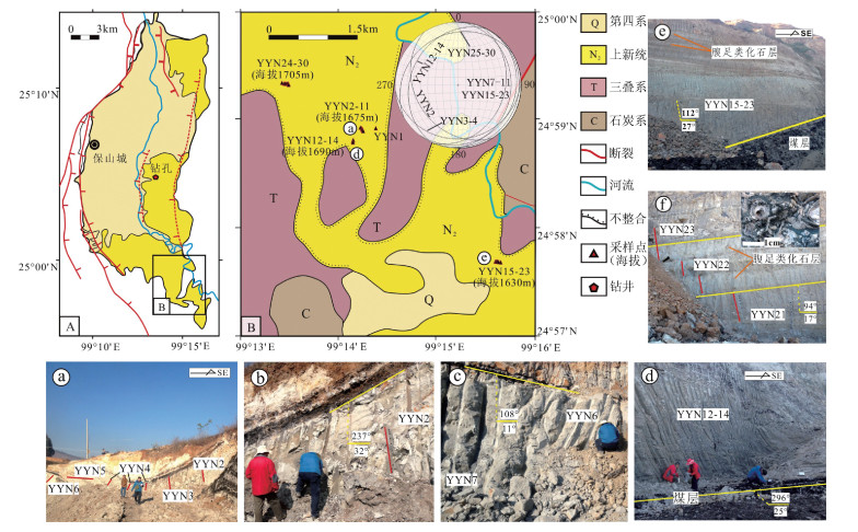
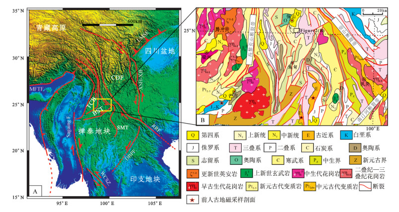
图 1 青藏高原东南缘研究区构造地质简图(A, 据参考文献[44]修改)和保山地体北部及邻区地质简图(B)
(采样点位于保山地体北部保山盆地羊邑组中)
CDF—川滇断块;SMT—思茅地体;BST—保山地体;TCB—腾冲地块;LMSF—龙门山断裂;XSH-XJF—鲜水河小江断裂;RRF—哀牢山-红河断裂;DBPF—奠边府断裂;WCSZ—王朝韧性剪切带;MFTF—主前缘逆冲断裂带Figure 1. Schematic tectonic geological map of the southeastern edge of Tibetan Plateau (A) and tectonic map of the North Baoshan Terrane (B)
![]()
图 2 保山盆地构造简图(A)和盆地南缘羊邑煤矿上新世羊邑组YYN古地磁采样点分布图(B)
(a~f为野外剖面部分照片)
Figure 2. Tectonic map of Baoshan Basin (A) and tectonic map of the paleomagnetic sampling section YYN in the Pliocene Yangyi Formation of southern part of the Baoshan Basin (B)
![]()
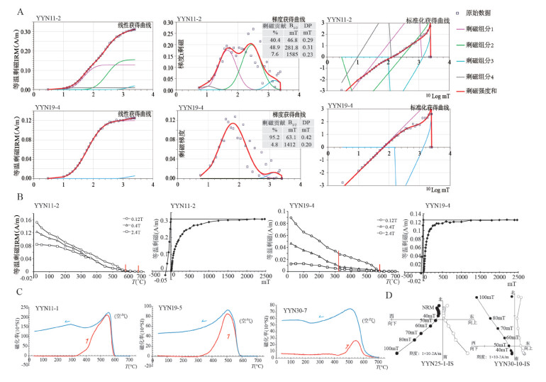
图 3 岩石磁学实验代表样品结果图
Figure 3. Rock magnetic results for representative specimens from the Pliocene Yangyi Formation
![]()
图 4 保山盆地上新统羊邑组岩石磁化率各向异性(AMS)实验结果
(a从左到右分别是等面积投影图、Pj-Km、T-P和磁化率椭球体3个轴的玫瑰花图,玫瑰花图中红色和蓝色箭头分别代表主压应力方向和主张应力方向)
Figure 4. Measurement results of anistropy magnetic susceptibility (AMS) of Pliocene Yangyi Formation in Baoshan Terrane
![]()
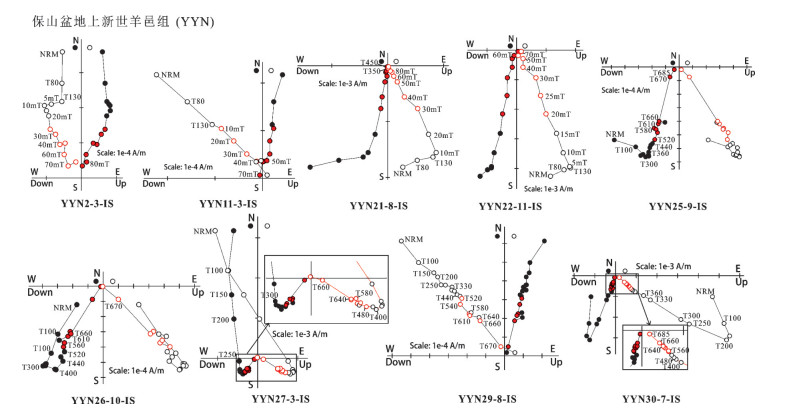
图 5 保山盆地羊邑组HZN、YYN剖面代表样品退磁Zj正交矢量图
(地层校正前)(实心和空心符号分别代表水平面和垂直面投影图,红色重点展示用于拟合特征剩磁的退磁步骤)
Figure 5. Orthogonal projections of magnetization vector endpoints for representative specimens of HZN section and YYN section of the Pliocene Yangyi Formation in Baoshan Basin
![]()
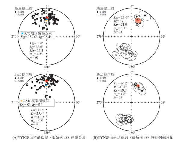
图 6 YYN剖面低温(低矫顽力)和高温(高矫顽力)剩磁分量等面积投影图
(实心圆、空心圆分别代表上、下球面投影,灰色实心圆代表空心圆在球面投影上的对跖点;红色、蓝色、橙色五角星分别代表平均方向、现代地球磁场方向和GAD模型期望地球磁场方向)
Figure 6. Equal-area projection of the site mean directions of the low temperature components and ChRMs of YYN section before and after tilt correction
![]()
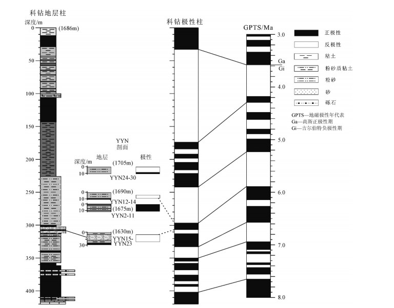
图 7 保山盆地YYN古地磁剖面地层和极性与汉庄镇钻井磁性地层结果对比
Figure 7. Magnetic stratigraphy study of YYN section of Pliocene Yangyi Formation, and the regional stratigraphic correlation with the result of magnetic stratigraphy study of the scientific drill hole near Hanzhuanng Town
![]()
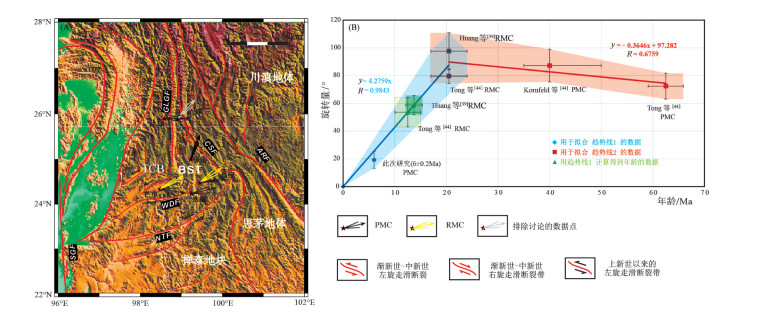
图 8 保山地体和腾冲地块古地磁偏角数据分布图(A)(箭头指示平均方向,两边短线代表误差值)和腾冲地块、保山地体旋转量-地质年龄图解(B)
TCB—腾冲地块;BST—保山地体;ARF—哀牢山-红河断裂带;NTF—南汀河断裂;WDF—畹町断裂;GLGF—高黎贡断裂带;CSF—崇山断裂带;SGF—实皆断裂;PMC—原生剩磁分量;RMC—次生剩磁分量
Figure 8. Paleomagnetic declinations obtained from the BST and TCB(A) and the rotational-age diagram of Baoshan Terrane (B)
![]()
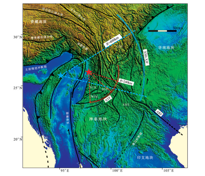
图 9 保山地体以南汀河断裂带为旋转边界的旋转量构造简图
SMT—思茅地体;BST—保山地体;TCB—腾冲地块;CDF—川滇断块;ARF—哀牢山-红河断裂;NTF—南汀河断裂;WDF—畹町断裂;GLGF—高黎贡断裂带;CSF—崇山断裂带;WCSZ—王朝韧性剪切带;XSH-XJF—鲜小河小江断裂
Figure 9. Generalized tectonic map illustrating the rotation of the Baoshan Terrane around the fitted Euler pole (red star) along the Nantinghe fault system
表 1 保山地体上新世羊邑组YYN剖面各采点磁化率各向异性(AMS)测试结果
Table 1 Measurement results of anistropy magnetic susceptibility (AMS) of YYN section, Pliocene Yangyi Formation in Baoshan Terrane
采点 坐标N/E 走向/倾角/º n Km×10-6SI L F Pj T K1 K2 K3 q K1D/I(º) K2D/I(º) K3D/I(º) YYN2 24°59′/99°14′ 147/32 10 140 1.004 1.013 1.018 0.564 1.006 1.003 0.991 0.22 322.6/0.9 232.6/2.8 69.8/87.1 YYN3 24°59′/99°14′ 135/16 7 119 1.002 1.024 1.029 0.816 1.009 1.007 0.984 0.08 342/2.8 252/1.3 136.6/86.9 YYN4 24°59′/99°14′ 346/4 6 100 1.002 1.026 1.032 0.826 1.009 1.006 0.985 0.13 139.3/4.1 49.2/2.6 287.5/85.1 YYN5 24°59′/99°14′ 18/11 6 96 1.006 1.026 1.034 0.627 1.01 1.008 0.983 0.08 280.5/2.8 190.4/1.6 71.4/86.8 YYN6 24°59′/99°14′ 8/3 6 138 1.006 1.037 1.047 0.768 1.014 1.01 0.976 0.11 84.8/10.2 354.4/1.9 253.9/79.6 YYN7 24°59′/99°14′ 25/4 6 111 1.008 1.016 1.025 0.331 1.01 1.002 0.988 0.44 275.2/0.9 185.1/6.5 13.3/83.4 YYN8 24°59′/99°14′ 25/4 6 125 1.011 1.014 1.026 0.094 1.008 1.004 0.988 0.22 92.2/9.8 183/4.9 299.2/79.1 YYN9 24°59′/99°14′ 25/4 6 129 1.01 1.01 1.02 0.028 1.009 1 0.99 0.62 102.4/10.5 193/3.5 301.1/78.9 YYN10 24°59′/99°14′ 37/30 6 114 1.007 1.019 1.028 0.462 1.009 1.004 0.986 0.24 114.9/0.2 204.9/5.8 22.7/84.2 YYN11 24°59′/99°14′ 206/25 6 218 1.007 1.012 1.02 0.216 1.009 1.002 0.989 0.42 106.9/2 16.6/8.5 209.8/81.3 YYN12 24°59′/99°14′ 206/25 6 183 1.006 1.018 1.026 0.504 1.01 1.004 0.986 0.29 114/0.8 204.1/6.5 16.9/83.4 YYN13 24°59′/99°14′ 206/25 6 311 1.004 1.019 1.025 0.607 1.008 1.005 0.987 0.15 109.2/4 200.1/12.4 1.8/77 YYN14 24°59′/99°14′ 206/25 5 172 1.002 1.021 1.026 0.792 1.008 1.006 0.986 0.1 114.2/5.1 204.8/6.7 346.9/81.5 YYN15 24°58′/99°16′ 22/27 6 126 1.003 1.021 1.026 0.747 1.008 1.005 0.987 0.15 280/10.4 11/5.6 128.8/78.2 YYN16 24°58′/99°16′ 22/27 6 121 1.004 1.019 1.025 0.523 1.007 1.004 0.99 0.19 330.9/4.8 240.6/3.7 112.8/83.9 YYN17 24°58′/99°16′ 22/27 6 103 1.005 1.015 1.021 0.384 1.005 1.003 0.992 0.17 333/20 241.4/4.6 139.1/69.4 YYN18 24°58′/99°16′ 22/27 6 98 1.006 1.016 1.023 0.422 1.007 1.002 0.991 0.37 318.4/8 50.3/13.3 198.3/74.4 YYN19 24°58′/99°16′ 22/27 6 148 1.006 1.011 1.018 0.241 1.003 1.001 0.996 0.33 293.9/22.4 27.5/8.7 137.3/65.8 YYN20 24°58′/99°16′ 22/27 6 108 1.004 1.008 1.012 0.252 1.005 1.001 0.994 0.44 300.4/14.9 31.7/4.8 139.1/74.3 YYN21 24°58′/99°16′ 4/17 6 108 1.002 1.022 1.027 0.759 1.008 1.007 0.985 0.04 300.8/5.2 210.4/4.5 79.9/83.1 YYN22 24°58′/99°16′ 4/17 10 159 1.002 1.023 1.028 0.832 1.008 1.007 0.985 0.04 306.1/3.9 215.8/3.6 83.3/84.7 YYN24 24°59′/99°13′ 近水平 7 222 1.006 1.026 1.034 0.641 1.011 1.007 0.982 0.15 160.1/4.7 68.7/16.7 265.3/72.7 YYN25 24°59′/99°13′ 240/19 6 147 1.004 1.015 1.021 0.558 1.007 1.004 0.989 0.18 130.3/1.1 40.2/2.7 242.1/87.1 YYN26 24°59′/99°13′ 240/19 6 155 1.005 1.021 1.028 0.652 1.007 1.006 0.987 0.05 114.7/1.7 24.5/9.2 215.1/80.6 YYN27 24°59′/99°13′ 24019 6 136 1.004 1.016 1.022 0.595 1.006 1.003 0.991 0.22 111.8/1.2 21.8/2.4 228/87.3 YYN28 24°59′/99°13′ 24019 6 140 1.002 1.015 1.019 0.698 1.006 1.004 0.99 0.13 321.4/2.4 51.8/7.6 214.2/82.1 YYN29 24°59′/99°13′ 24019 6 277 1.006 1.023 1.032 0.571 1.012 1.005 0.983 0.27 301.2/3.5 31.4/3.7 167.6/84.9 YYN30 24°59′/99°13′ 近水平 6 307 1.004 1.023 1.029 0.699 1.01 1.006 0.984 0.17 292.6/3.1 22.7/1.6 139.8/86.5 YYN-ALL 177 1.54E-04 1.005 1.019 1.026 0.551 1.007 1.005 0.988 0.11 117.8/0 27.8/1.2 208.6/88.8 注:n为样品数;Km是平均磁化率;磁线理L=K1/K2;磁面理F=K2/K3;形态参数T=(2η2-η1-η3)/(η1-η3);η1=InK1,η2=InK2,η3=InK3,ηm=(η1+η2+η3)/3;各向异性度p=exp{sqrt[2×((η1-ηm)2+(η2-ηm)2+(η3-ηm)2]};f=90-K3;q=(K1-K2)/[(K1+K2)/2-K3]  下载: 导出CSV
表 2 保山地体北部保山盆地上新世羊邑组YYN剖面特征剩磁分量
Table 2 High-temperature magnetic components of the Pliocene Yangyi Formation of section YYN in the central part of the Baoshan Basin in the north part of Baoshan Terrane
采点 坐标 地层产状 n/N 地层校正前 地层校正后 Kg/Ks α95g/α95s 虚地磁极VGP N/E 走向/倾角(º) 偏角(º) 倾角(º) 偏角(º) 倾角(º) 纬度(°N) 经度(°E) A95(º) YYN2 24°58′52″/99°14′12″ 147/32 9/ 32.4 12.9 24.3 41.2 13.6 14.5 67.8 187.6 13.8 YYN4 24°58′52″/99°14′12″ 85/16 10/ 14.2 28.8 14.4 37.5 59.4/69 6.4/6.0 76.2 203.1 5.4 YYN7 24°58′52″/99°14′12″ 25/4 8/ 18.2 36.1 22.1 36.2 23.6/23.0 11.6/11.8 69 198.2 10.5 YYN11 24°58′52″/99°14′12″ 37/10 11/ 32.2 43.8 41.8 43.8 22.5 11.2 52.4 179 11.1 YYN12 24°58′44″/99°14′07″ 206/25 8/ 219.9 -15.1 210.3 -20.3 29.1/31.4 10.4/10.0 57.8 210.6 7.6 YYN17 24°57′33″/99°15′41″ 22/27 8/ 197.7 -33.9 215.4 -31.6 20.5 12.6 56.1 195.7 10.6 YYN20 24°57′33″/99°15′41″ 22/27 7/ 183 -30.2 200.3 -34.9 19.9 14 70.4 202.2 12.2 YYN21 24°57′33″/99°15′41″ 22/27 8/ 174.2 -37.8 187.8 -38.7 32.8 9.8 82.2 211.4 9 YYN22 24°57′33″/99°15′41″ 4/17 9/ 175.2 -33.9 186.9 -34.8 91.7 5.4 81.4 230.2 4.7 YYN24 24°59′20″/99°13′27″ 近水平 9/ 188.6 -46.4 188.6 -46.4 43.3 7.9 81.8 167.9 8.1 YYN25 24°59′20″/99°13′27″ 240/19 12/ 227 -42.6 212.2 -35.9 17.4 10.7 59.9 192.4 9.5 YYN26 24°59′20″/99°13′27″ 240/19 7/ 202.9 -52.6 188.6 -39.2 67.9 7.4 81.6 207 6.8 YYN27 24°59′20″/99°13′27″ 240/19 11/ 217.2 -53.1 202.2 -40.2 23.9 9.5 69.6 190.5 8.9 YYN28 24°59′20″/99°13′27″ 240/19 10/ 216.4 -40.2 204.5 -30.7 19.5 11.2 65.6 204.8 9.3 YYN29 24°59′20″/99°13′27″ 240/19 8/ 207.1 -51.1 192.5 -38.7 15.6 14.5 78.1 202.1 13.3 YYN30 24°59′20″/99°13′27″ 240/19 10/ 22.2 49.3 9.5 35.9 79.8 5.4 79.9 217.5 4.8 YYN剖面高温剩磁分量平均方向 /16 21.6 39.1 20.2 37.1 21.9/59.7 8.1/4.8 71 197.6 5 注:褶皱检验:99%置信度下通过褶皱检验[71],Kc/Ks=2.72,F(30, 30) =2.38;通过褶皱检验[69],DC slope:0.94±0.273;倒转检验:95%置信度下通过C类检验,平均γ=3.9 < 标准γ=10.6;n和N分别是古地磁采点内采样数和用于统计的采点数;k是统计精确度指数;α95和A95是平均方向95%置信度区间
下载: 导出CSV
表 3 保山地体和腾冲地块白垩纪—新生代古地磁数据
Table 3 The Cretaceous and Cenozoic paleomagnetic data obtained from the Baoshan Terrane and the Tengchong Terrane
研究区 坐标(N/E) 地层时代 N/n 观测值 古纬度 虚地磁极VGP 相对于东亚稳定区 磁化类型 参考文献 偏角(°) 倾角(°) α95 观测值(°N) 期望值(°N) 纬度(°N) 经度(°E) A95 (°) k 旋转量(°) 纬度运移量(°) 参考极 BST (永德) 24.2°/99.0° 古新世 5 76.9 17.8 10.4 9.1±5.6 17.3±4.1 15.6 186.2 8.3 86.3 72.4±9.4 8.2±7.4 60Ma 原生分量 [44] TCB (片马) 25.9°/98.8° 约40Ma 5/ 89.8 35.1 11.8 19.7±7.8 18.3±4.2 8.5 171.3 10.3 87.2±11.8 1.1±8.9 40Ma 原生分量 [43] BST (芒市) 24.3°/98.4° 中新世 6/ 99.7 35.2 11.3 19.4±7.5 19.4±3.1 -0.5 166.8 12.2 97.6±13.3 0.0±10.1 20Ma 重磁化分量 [39] BST (昌宁) 24.4°/99.3° 中新世 22/ 81.7 35.1 3.8 19.4±2.5 19.5±3.1 15.1 174.6 3.8 66.3 79.6±5.2 0.2±3.9 20Ma 重磁化分量 [44] BST (芒市) 24.3°/98.4° 中新世 6/ 60.9 32 5.9 17.4±3.7 19.0±3.1 33.1 182.9 5.8 58.7±6.9 2.1 ±5.3 20Ma 重磁化分量 [43] BST (昌宁) 24.4°/99.3° 中新世 /11 55.8 47.1 9 28.3±7.5 19.5±3.1 40.3 172 8.9 53.6±10.6 -8.8±7.5 20Ma 重磁化分量 [44] BST (六库) 26.0°/ 98.8° 约30Ma 12/ 42.3 47 7.8 28.2±6.5 20.2±2.8 52.7 175.7 8.1 39.9±9.7 -8.0±6.9 30Ma [39] BST (保山) 25.0°/99.2° 中新世末6±0.2Ma 16/ 20.2 37.1 4.8 20.9±5.0 22.7±2.6 71 197.6 5.0 55.4 19.2±6.0 1.8±4.5 l0Ma 原生分量 本次研究 东亚磁极移曲线[7] 0Ma 纬度=89.0° 经度=76.6° k=200.7 A95=0.4° 10Ma 纬度=87.5° 经度=257.3° k=154.8 A95=2.6° 20Ma 纬度=84.7° 经度=255.9° k=112.5 A95=3.1° 30Ma 纬度=83.9° 经度=259.6° k=106.7 A95=2.8° 40Ma 纬度=81.9° 经度=260.8° k=94.8 A95=4.2° 60Ma 纬度=81.9° 经度=247.5° k=57.4 A95=4.1° 80Ma 纬度=79.5° 经度=216.9° k=42.2 A95=3.4° 注:N/n分别代表了用于古地磁结果统计的采点数和样品数;k是统计精确度指数;α95和A95是平均方向 95%置信度区间。旋转量: 正负值分别代表了顺时针旋转和逆时针旋转;纬向运移:正负值分别指示了南向纬向运移和北向纬向运移
下载: 导出CSV
-
Klootwijk C T, Gee J S, Peirce J W, et al. An early India-Asia contact:Paleomagnetic constraints from Ninetyeast Ridge, ODP Leg 121[J]. Geology, 1992, 20(5):395-398. doi: 10.1130/0091-7613(1992)020<0395:AEIACP>2.3.CO;2
Najman Y, Appel E, Bown P, et al. Timing of India-Asia collision:Geological, biostratigraphic, and palaeomagnetic constraints[J]. Journal of Geophysical Research, 2010, 115(B12):1-70. doi: 10.1029/2010JB007673
Copley A, Avouac J, Royer J. India-Asia collision and the Cenozoic slowdown of the Indian plate:Implications for the forces driving plate motions[J]. Journal of Geophysical Research Atmospheres, 2010, 115(B3):181-192. doi: 10.1029/2009JB006634
Dupont-Nivet G, Lippert P C, Van Hinsbergen D J J, et al. Palaeolatitude and age of the Indo-Asia collision:palaeomagnetic constraints[J]. Geophysical Journal International, 2010, 182(3):1189-1198. doi: 10.1111/j.1365-246X.2010.04697.x
Van Hinsbergen D J J, Kapp P, Dupont-Nivet G, et al. Restoration of Cenozoic deformation in Asia and the size of Greater India[J]. Tectonics, 2011, 193(5):8-16. http://www.geo.uu.nl/~forth/publications/Hinsbergen_2011a.pdf
Sun Z, Pei J, Li H, et al. Palaeomagnetism of late Cretaceous sediments from southern Tibet:Evidence for the consistent palaeolatitudes of the southern margin of Eurasia prior to the collision with India[J]. Gondwana Research, 2012, 21(1):53-63. doi: 10.1016/j.gr.2011.08.003
Cogné J P, Besse J, Chen Y, et al. A new Late Cretaceous to Present APWP for Asia and its implications for paleomagnetic shallow inclinations in Central Asia and Cenozoic Eurasian plate deformation[J]. Geophysical Journal International, 2013, 192(3):1000-1024. doi: 10.1093/gji/ggs104
Yang T, Ma Y, Zhang S, et al. New insights into the India-Asia collision process from Cretaceous paleomagnetic and geochronologic results in the Lhasa terrane[J]. Gondwana Research, 2015, 28(2):625-641. doi: 10.1016/j.gr.2014.06.010
Ma Y, Yang T, Bian W, et al. Paleomagnetic and geochronologic results of latest Cretaceous lava flows from the Lhasa terrane and their tectonic implications[J]. Journal of Geophysical Research Solid Earth, 2017, 122(11):8786-8809. doi: 10.1002/jgrb.v122.11
Tapponnier P, Peltzer G, Dain A Y L, et al. Propagating extrusion tectonics in Asia:New insights from simple experiments with plasticine[J]. Geology, 1982, 10(10):611-616. https://www.researchgate.net/publication/239225686_Propagating_extrusion_tectonics_in_Asia_New_insights_from_simple_experiments_with_plasticine
Leloup P H, Lacassin R, Tapponnier P, et al. The Ailao Shan-Red River shear zone (Yunnan, China), Tertiary transform boundary of Indochina[J]. Tectonophysics, 1995, 251(1/4):3-10. http://www.geo.tu-freiberg.de/tektono/downloadfiles/Leloup%20et%20al.,%20Ailao%20Shan,%20Yunnan,%20Tectonoph%20%20251,%203-84,%201995.pdf
Wang E. Late cenozoic Xianshuihe/Xiaojiang and Red River fault systems of southwestern Sichuan and central Yunnan, China[J]. Special Paper of the Geological Society of America, 1998, 327:1-108. https://www.researchgate.net/publication/279409427_Late_Cenozoic_Xianshuihe-Xiaojiang_Red_River_and_Dali_Fault_Systems_of_Southwestern_Sichuan_and_Central_Yunnan_China
Wang E, Burchfiel B C. Late Cenozoic to Holocene deformation in southwestern Sichuan and adjacent Yunnan, China, and its role in formation of the southeastern part of the Tibetan Plateau[J]. Geological Society of America Bulletin, 2000, 112(3):413-423. doi: 10.1130/0016-7606(2000)112<413:LCTHDI>2.0.CO;2
Molnar P, Dayem K E. Major intracontinental strike-slip faults and contrasts in lithospheric strength[J]. Geosphere, 2010, 6(4):444-467. doi: 10.1130/GES00519.1
Funahara S, Nishiwaki N, Murata F, et al. Clockwise rotation of the Red River fault inferred from paleomagnetic study of Cretaceous rocks in the Shan-Thai-Malay block of Western Yunnan, China[J]. Earth & Planetary Science Letters, 1993, 117(1/2):29-42.
Chen H, Dobson J, Heller F, et al. Paleomagnetic evidence for clockwise rotation of the Simao region since the Cretaceous:A consequence of India-Asia collision[J]. Earth & Planetary Science Letters, 1995, 134(1/2):203-217.
Otofuji Y I, Liu Y, Yokoyam M, et al. Tectonic deformation of the southwestern part of the Yangtze craton inferred from paleomagnetism[J]. Earth & Planetary Science Letters, 1998, 156(1/2):47-60. https://www.deepdyve.com/lp/elsevier/tectonic-deformation-of-the-southwestern-part-of-the-yangtze-craton-MFwVXvc6ad
Yang Z, Sun Z, Ma X H, et al. Palaeomagnetic Study of the Early Tertiary on both Sides of the Red River Fault and Its Geological Implications[J]. Acta Geologica Sinica, 2001, 75:35-44. https://www.researchgate.net/publication/283915275_Palaeomagnetic_study_of_the_early_Tertiary_on_both_sides_of_the_red_river_fault_and_its_geological_implications
Sato K, Liu Y, Zhu Z, et al. Tertiary paleomagnetic data from northwestern Yunnan, China:further evidence for large clockwise rotation of the Indochina block and its tectonic implications[J]. Earth & Planetary Science Letters, 2001, 185(1/2):185-198. https://www.sciencedirect.com/science/article/pii/S0012821X00003770
Yoshioka S, Yu Y L, Sato K, et al. Paleomagnetic evidence for post-Cretaceous internal deformation of the Chuan Dian Fragment in the Yangtze block:a consequence of indentation of India into Asia[J]. Tectonophysics, 2003, 376(1):61-74. https://www.deepdyve.com/lp/elsevier/paleomagnetic-evidence-for-post-cretaceous-internal-deformation-of-the-Qsmxafe64E
Tamai M, Liu Y, Lu L Z, et al. Palaeomagnetic evidence for southward displacement of the Chuan Dian fragment of the Yangtze Block[J]. Geophysical Journal International, 2004, 158(1):297-309. doi: 10.1111/gji.2004.158.issue-1
Tanaka K, Mu C, Sato K, et al. Tectonic deformation around the eastern Himalayan syntaxis:Constraints from the Cretaceous paleomagnetic data of the Shan-Thai Block[J]. Geophysical Journal International, 2008, 175:713-728. doi: 10.1111/gji.2008.175.issue-2
Otofuji Y I, Yokoyama M, Kitada K, et al. Paleomagnetic versus GPS determined tectonic rotation around eastern Himalayan syntaxis in East Asia[J]. Journal of Asian Earth Sciences, 2010, 37(5/6):438-451. https://www.deepdyve.com/lp/elsevier/paleomagnetic-versus-gps-determined-tectonic-rotation-around-eastern-UdbaGQOHvG
Tong Y B, Yang Z, Zheng L D, et al. Internal crustal deformation in the northern part of Shan-Thai Block:New evidence from paleomagnetic results of Cretaceous and Paleogene redbeds[J]. Tectonophysics, 2013, 608(47):1138-1158. http://adsabs.harvard.edu/abs/2013Tectp.608.1138T
Tong Y B, Yang Z, Wang H, et al. The Cenozoic rotational extrusion of the Chuan Dian Fragment:New paleomagnetic results from Paleogene red-beds on the southeastern edge of the Tibetan Plateau[J]. Tectonophysics, 2015, 658:46-60. doi: 10.1016/j.tecto.2015.07.007
Wang H, Yang Z, Tong Y, et al. Palaeomagnetic results from Palaeogene red beds of the Chuan-Dian Fragment, southeastern margin of the Tibetan Plateau:implications for the displacement on the Xianshuihe-Xiaojiang fault systems[J]. International Geology Review, 2016, 58(11):1363-1381. doi: 10.1080/00206814.2016.1157710
Gao L, Yang Z, Tong Y, et al. Cenozoic clockwise rotation of the Chuan Dian Fragment, southeastern edge of the Tibetan Plateau:Evidence from a new paleomagnetic study[J]. Journal of Geody-namics, 2017, 112:46-57. doi: 10.1016/j.jog.2017.10.001
Shen Z K, Lü J, Wang M, et al. Contemporary crustal deformation around the southeast borderland of the Tibetan Plateau[J]. Journal of Geophysical Research Solid Earth, 2005, 110(B11409):1-17.
Gan W, Zhang P, Shen Z K, et al. Present-day crustal motion within the Tibetan Plateau inferred from GPS measurements[J]. Journal of Geophysical Research Solid Earth, 2007, 112(B8):582-596.
Molnar P, Tapponnier P. Cenozoic Tectonics of Asia:Effects of a Continental Collision:Features of recent continental tectonics in Asia can be interpreted as results of the India-Eurasia collision.[J]. Science, 1975, 189(4201):419-426. doi: 10.1126/science.189.4201.419
England P, Houseman G. Finite strain calculations of continental deformation:2. Comparison with the India-Asia Collision Zone[J]. Journal of Geophysical Research, 1986, 91(91):3664-3676. https://www.researchgate.net/publication/248790767_Finite_strain_calculations_of_continental_deformation_2_Comparison_with_the_India-Asia_Collision_Zone
Peltzer G, Tapponnier P, Gaudemer Y, et al. Offsets of Late Quaternary morphology, rate of slip, and recurrence of large earthquakes on the Chang Ma Fault (Gansu, China)[J]. Journal of Geophysical Research Solid Earth, 1988, 93(B7):7793-7812. doi: 10.1029/JB093iB07p07793
Bird P. Lateral extrusion of lower crust from under high topography in the isostatic limit[J]. Journal of Geophysical Research Solid Earth, 1991, 96(B6):10275-10286. doi: 10.1029/91JB00370
Clark M K, Royden L H. Topographic ooze:Building the eastern margin of Tibet by lower crustal flow[J]. Geology, 2000, 28(8):703-706. doi: 10.1130/0091-7613(2000)28<703:TOBTEM>2.0.CO;2
Royden L H, Burchfiel B C, King R W, et al. Surface Deformation and Lower Crustal Flow in Eastern Tibet[J]. Science, 1997, 276(5313):788-790. doi: 10.1126/science.276.5313.788
ErchieWang, Burchfiel B C. Interpretation of Cenozoic Tectonics in the Right-Lateral Accommodation Zone Between the Ailao Shan Shear Zone and the Eastern Himalayan Syntaxis[J]. International Geology Review, 1997, 39(3):191-219. doi: 10.1080/00206819709465267
Wu Z H, Long C, Fan T, et al. The arc rotational-shear active tectonic system on the southeastern margin of Tibetan Plateau and its dynamic characteristics and mechanism[J]. Geological Bulletin of China, 2015, 34(1):1-31.
Huang K, Opdyke N D. Paleomagnetism of Cretaceous to lower Tertiary rocks from southwestern Sichuan:a revisit[J]. Earth & Planetary Science Letters, 1992, 112(1/4):29-40. https://www.researchgate.net/publication/248411400_Paleomagnetism_of_Cretaceous_to_Lower_Tertiary_rocks_from_Southwestern_Sichuan_a_revisit
Huang K, Opdyke N D. Paleomagnetic results from Cretaceous and Jurassic rocks of South and Southwest Yunnan:evidence for large clockwise rotations in the Indochina and Shan-Thai-Malay terranes[J].Earth & PlanetaryScienceLetters, 1993, 117(3/4):507-524. https://www.researchgate.net/publication/248411556_Paleomagnetic_results_from_Cretaceous_and_Jurassic_rocks_of_South_and_Southwest_Yunnan_evidence_for_large_clockwise_rotations_in_the_Indochina_and_Shan-Thai-Malay_terranes
Yang Z Y, Besse J, Sutheetorn V, et al. Lower-Middle Jurassic paleomagnetic data from the Mae Sot area (Thailand):Paleogeographic evolution and deformation history of Southeastern Asia[J]. Earth & Planetary Science Letters, 1995, 136(3):325-341. https://www.researchgate.net/publication/248411730_Lower-Middle_Jurassic_paleomagnetic_data_from_the_Mae_Sot_area_Thailand_Paleogeographic_evolution_and_deformation_history_of_Southeastern_Asia
Gao L, Yang Z, Tong Y, et al. New paleomagnetic studies of Cretaceous and Miocene rocks from Jinggu, western Yunnan, China:Evidence for internal deformation of the Lanping-Simao Terrane[J]. Journal of Geodynamics, 2015, 89:39-59. doi: 10.1016/j.jog.2015.06.004
Tsuchiyama Y, Zaman H, Sotham S, et al. Paleomagnetism of Late Jurassic to Early Cretaceous red beds from the Cardamom Mountains, southwestern Cambodia:Tectonic deformation of the Indochina Peninsula[J]. Earth & Planetary Science Letters, 2016, 434(7):274-288. https://www.researchgate.net/publication/287199545_Paleomagnetism_of_Late_Jurassic_to_Early_Cretaceous_red_beds_from_the_Cardamom_Mountains_southwestern_Cambodia_Tectonic_deformation_of_the_Indochina_Peninsula
Kornfeld D, Eckert S, Appel E, et al. Cenozoic clockwise rotation of the Tengchong block, southeastern Tibetan Plateau:A paleomagneticandgeochronologicstudy[J].Tectonophysics, 2014, 628:105-122. doi: 10.1016/j.tecto.2014.04.032
Tong Y, Yang Z, Jing X, et al. New insights into the Cenozoic lateral extrusion of crustal blocks on the southeastern edge of Tibetan Plateau:Evidence from paleomagnetic results from Paleogene sedimentary strata of the Baoshan Terrane[J]. Tectonics, 2016, 35(11):2494-2514. doi: 10.1002/2016TC004221
卢海建, 王二七, 李仕虎, 等.青藏高原东南缘构造旋转变形分析:以四川盐源盆地古地磁研究为例[J].中国地质, 2015(5):1188-1201. http://www.cnki.com.cn/Article/CJFDTOTAL-DIZI201505002.htm Akciz S, Burchfiel B C, Crowley J L, et al. Geometry, kinematics, and regional significance of the Chong Shan shear zone, Eastern Himalayan Syntaxis, Yunnan, China[J]. Geosphere, 2008, 4(1):292. doi: 10.1130/GES00111.1
Xu Z, Ji S, Cai Z, et al. Kinematics and dynamics of the Namche Barwa Syntaxis, eastern Himalaya:Constraints from deformation, fabricsandgeochronology[J].GondwanaResearch, 2012, 21(1):19-36. https://www.deepdyve.com/lp/elsevier/kinematics-and-dynamics-of-the-namche-barwa-syntaxis-eastern-himalaya-Lgjea9bBbT
Wang Y, Fan W, Zhang Y, et al. Kinematics and 40Ar/39Ar geochronology of the Gaoligong and Chongshan shear systems, western Yunnan, China:Implications for early Oligocene tectonic extrusion of SE Asia[J]. Tectonophysics, 2006, 418(3/4):235-254.
Lin T H, Lo C H, Chung S L, et al. 40Ar/39Ar dating of the Jiali and Gaoligong shear zones:Implications for crustal deformation around the Eastern Himalayan Syntaxis[J]. Journal of Asian Earth Sciences, 2009, 34(5):674-685. doi: 10.1016/j.jseaes.2008.10.009
Wopfner H. Gondwana origin of the Baoshan and Tengchong terranes of west Yunnan[J]. Geological Society of London, 1996, 106(1):539-547. doi: 10.1144/GSL.SP.1996.106.01.34
戴苏兰, 赵泽江.云南保山盆地的形成与演化[J].矿物岩石, 1998, (s1):116-123. http://mall.cnki.net/magazine/Article/SYSD199802002.htm 张远志.云南省岩石地层[M].武汉:中国地质大学出版社, 1996. Thebault E, Finlay C, Group T I W. The International Geomagnetic Reference Field:the twelfth generatio[J]. Geophysical Journal International, 2010, 183(3):1216-1230. doi: 10.1111/j.1365-246X.2010.04804.x
Lowrie W. Identification of ferromagnetic minerals in a rock by co-ercivity and unblocking temperature properties[J]. Geophysical Research Letters, 1990, 17(2):159-162. doi: 10.1029/GL017i002p00159
Dunlop D J, Özdemir Ö. Rock Magnetism:Fundamentals and Frontiers[M]. Cambridge University Press, 1997.
Maher B A, Thompson R. Quaternary Climates, Environments and Magnetism[M]. Cambridge Univ. Press, 1999.
Hüsing S K, Dekkers M J, Franke C, et al. The Tortonian reference section at Monte dei Corvi (Italy):evidence for early remanence acquisition in greigite-bearing sediments[J]. Geophysical Journal International, 2009, 179(1):125-143. doi: 10.1111/gji.2009.179.issue-1
Passier H F, De Lange G J, Dekkers M J. Magnetic properties and geochemistry of the active oxidation front and the youngest sapropel in the eastern Mediterranean Sea[J]. Geophysical Journal International, 2001, 145(3):604-614. doi: 10.1046/j.0956-540x.2001.01394.x
Roberts A P, Chang L, Rowan C J, et al. Magnetic properties of sedimentary greigite (Fe3S4):An update[J]. Reviews of Geophysics, 2011, 49(1):RG1002(1-46). http://www.academia.edu/2539348/MAGNETIC_PROPERTIES_OF_SEDIMENTARY_GREIGITE_Fe3S4_AN_UPDATE
Duan Z, Liu Q, Gai C, et al. Magnetostratigraphic and environmental implications of greigite (Fe3S4) formation from Hole U1433A of the IODP Expedition 349, South China Sea[J]. Marine Geology, 2017, 394:82-97. doi: 10.1016/j.margeo.2017.02.008
Kruiver P P, Dekkers M J, Heslop D. Quantification of magnetic coercivity components by the analysis of acquisition curves of isothermal remanent magnetisation[J]. Earth & Planetary Science Letters, 2001, 189(3/4):269-276. https://www.deepdyve.com/lp/elsevier/quantification-of-magnetic-coercivity-components-by-the-analysis-of-T6wAQPEMFs
Heslop D, Dillon M. Unmixing magnetic remanence curves without a priori knowledge[J]. Geophysical Journal of the Royal Astronomical Society, 2007, 170(2):556-566. doi: 10.1111/gji.2007.170.issue-2
Tarling D H, Hrouda F. The magnetic anisotropy of rocks[M]. Chapman and Hall, London, 1993.
罗良, 贾东, 陈竹新, 等.川西北磁组构演化及其揭示的应变特征[J].地质通报, 2006, 25(11):1342-1348. doi: 10.3969/j.issn.1671-2552.2006.11.015 Luo L, Jia D, Li H, et al. Magnetic fabric investigation in the northwestern Sichuan Basin and its regional inference[J]. Physics of the Earth & Planetary Interiors, 2009, 173(1/2):103-114. https://www.doc88.com/p-6721222546522.html
Zijderveld A C. Demagnetization of rocks: Analysis of results[C]//Collinson D W, Creer K M, Runcorn S K. Methods in Paleomagnetism, Methods in Paleomagnetism. Elsevier, Amsterdam, 1967: 254-286.
Kirschvink J L. The least-squares line and plane and the analysis of palaeomagnetic data[J]. Geophysical Journal International, 1980, 62(3):699-718. doi: 10.1111/gji.1980.62.issue-3
Fisher R. Dispersion on a Sphere[J]. Proceedings of the Royal Society of London, 1953, 217(1130):295-305. doi: 10.1098/rspa.1953.0064
Enkin R J. A computer program package for analysis and presentation of paleomagnetic data[J]. Pacific Geoscience Centre, Geological Survey of Canada, 1994:1-16. doi: 10.2478/s11600-006-0016-9
Cogné J P. PaleoMac:A MacintoshTM application for treating paleomagnetic data and making plate reconstructions[J]. Geochemistry Geophysics Geosystems, 2003, 4(1):233-236. https://www.researchgate.net/publication/228535927_PaleoMac_A_MacintoshTM_application_for_treating_paleomagnetic_data_and_making_plate_reconstructions
Mcelhinny M W. Statistical Significance of the Fold Test in Palaeo-magnetism[J]. Geophysical Journal of the Royal Astronomical Society, 1964, 8(3):338-340.
Enkin R J. The direction-correction tilt test:an all-purpose tilt/fold test for paleomagnetic studies[J]. Earth & Planetary Science Letters, 2003, 212(1/2):151-166. https://www.deepdyve.com/lp/elsevier/the-direction-correction-tilt-test-an-all-purpose-tilt-fold-test-for-fW5BxTtg0A
Mcfadden P L, Mcelhinny M W. Classification of the reversal test in palaeomagnetism[J]. Geophysical Journal International, 1990, 103(3):725-729. doi: 10.1111/gji.1990.103.issue-3
汪彦, 彭军, 李凯军, 等.高分辨率层序地层学在保山盆地永铸街凸起构造-沉积演化中的应用[J].天然气地球科学, 2005, 16(6):741-746. http://www.wanfangdata.com.cn/details/detail.do?_type=perio&id=trqdqkx200506011 Kornfeld D, Eckert S, Appel E, et al. Clockwise rotation of the Baoshan Block due to southeastward tectonic escape of Tibetan crust since the Oligocene[J]. Geophysical Journal International, 2014, 197(1):149-163. doi: 10.1093/gji/ggu009
Spurlin M S, Yin A, Horton B K, et al. Structural evolution of the Yushu-Nangqian region and its relationship to syncollisional igneous activity, eastcentral Tibet[J]. Geological Society of America Bulletin, 2005, 117(9/10):1293-1317. http://www.researchgate.net/publication/235980451_Structural_evolution_of_the_Yushu-Nangqian_region_and_its_relationship_to_syn-collisional_igneous_activity_east-central_Tibet
Aikman A B, Harrison T M, Lin D. Evidence for Early (>44Ma) Himalayan Crustal Thickening, Tethyan Himalaya, southeastern Tibet[J]. Earth & Planetary Science Letters, 2008, 274(1/2):14-23.
Tong Y, Yang Z, Mao C, et al. Paleomagnetism of Eocene redbeds in the eastern part of the Qiangtang Terrane and its implications for uplift and southward crustal extrusion in the southeastern edge of the Tibetan Plateau[J]. Earth & Planetary Science Letters, 2017, 475:1-14
Tang M, Jing L Z, Hoke G D, et al. Paleoelevation reconstruction of the Paleocene-Eocene Gonjo basin, SE-central Tibet[J]. Tectonophysics, 2017, (712/713):170-181. http://www.sciencedirect.com/science/article/pii/S0040195117302019
Lan J B, Xu Y G, Yang Q J, et al.~40Ma OIB-type mafic magmatism in the Gaoligong belt:results of break-off between subducting Tethyan slab and Indian plate?[J]. Acta Petrologica Sinica, 2007, 23(6):1334-1346. http://en.cnki.com.cn/Article_en/CJFDTOTAL-YSXB200706009.htm
Yang Z, Hou Z, Yang Z, et al. Genesis of porphyries and tectonic controls on the Narigongma porphyry Mo(-Cu) deposit, southern Qinghai[J]. Acta Petrologica Sinica, 2008, 24(3):489-502. https://www.researchgate.net/publication/257941275_Genesis_of_porphyries_and_tectonic_controls_on_the_Narigongma_porphyry_Mo-Cu_deposit_Southern_Qinghai
Wang Q, Wyman D A, Li Z X, et al. Eocene north-south trending dikes in central Tibet:New constraints on the timing of east-west extension with implications for early plateau uplift?[J]. Earth & Planetary Science Letters, 2010, 298(1):205-216.
Sato K, Liu Y, Wang Y, et al. Paleomagnetic study of Cretaceous rocks from Pu'er, western Yunnan, China:Evidence of internal deformation of the Indochina block[J]. Earth & Planetary Science Letters, 2007, 258(1/2):1-15. http://www.sciencedirect.com/science/article/pii/S0012821X07000854
Li S H, Advokaat E L, Hinsbergen D J J V, et al. Paleomagnetic constraints on the Mesozoic-Cenozoic paleolatitudinal and rotational history of Indochina and South China:Review and updated kinematic reconstruction[J]. Earth-Science Reviews, 2017, 171:58-77. doi: 10.1016/j.earscirev.2017.05.007
仝亚博, 杨振宇, 王恒, 等.中国西南思茅地体中部白垩纪古地磁结果及陆内地壳变形特征[J].地球物理学报, 2014, 57(1):179-198. doi: 10.6038/cjg20140116 徐锡伟, 张培震, 闻学泽, 等.川西及其邻近地区活动构造基本特征与强震复发模型[J].地震地质, 2005, 27(3):446-461. http://www.wanfangdata.com.cn/details/detail.do?_type=perio&id=dzdz200503010 Socquet A, Pubellier M. Cenozoic deformation in western Yunnan (China-Myanmar border)[J]. Journal of Asian Earth Sciences, 2005, 24(4):495-515. doi: 10.1016/j.jseaes.2004.03.006
杨振宇, 王树兵, 仝亚博, 等. 青藏高原东南缘晚新生代年代地层及旋转变形过程的古地磁学限定(地质调查项目(12120114002301)成果报告). 2017.


计量
- 文章访问数: 3367
- HTML全文浏览量: 339
- PDF下载量: 1938
