The role of blind fault in soil liquefaction during strong earthquake: A case study of the 2008 Wenchuan Mw7.9 earthquake
-
摘要:
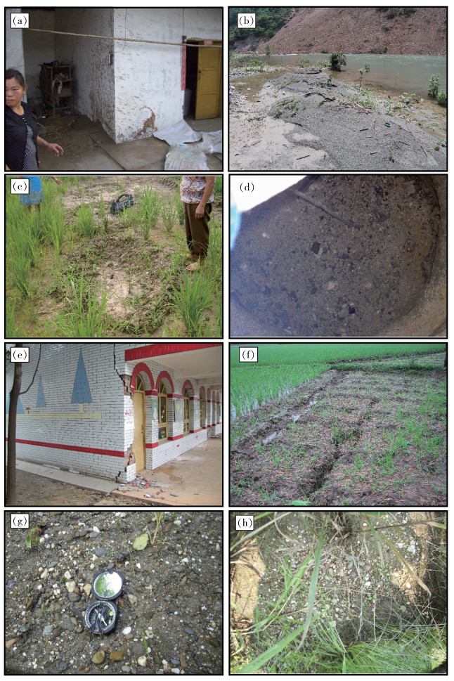
2008年汶川Mw7.9地震的强地面震动在龙门山前地区造成大量的砂土液化、喷砂冒水等地震灾害现象。震后野外调查发现,砂土液化点主要分布于地下水位只有几米深的山前河流的低阶地处,以大面积砾性土液化为特征,约58%的液化点位于距北川断层20~35km的范围内。对喷水高度及喷水过程进行了详细记录,喷水高度与峰值加速度并没有明显的相关性,喷水高度异常点(>2m)集中于山前断裂系统近地表投影处。汶川地震中喷水高度异常、砾性土液化的位置与山前断裂系统的吻合性说明,沉积盆地内的地质构造可能在砂土液化强度和与震动相关的地震灾害方面起到促进作用,所以在类似的地质和水文环境中,除主震的断层错动外,应考虑地质构造在地震危险性评估和建筑物抗震设计中的重要作用。
Abstract:Strong ground shaking during the 2008 Wenchuan Mw7.9 earthquake caused widespread seismic hazard phenomena, such as sand liquefaction and water ejection, in the foothills of the Longmen Mountain in southwestern China. The results of field investi-gation after the earthquake showed that the majority of liquefaction sites occurred along major alluvial fan-building rivers, where the water table was a few meters below the surface and the earthquake was characterized by widespread gravely sand liquefaction, with ~58% of liquefaction sites located 20~35km from the Beichuan fault. The authors recorded the water ejection height and the process of water ejection for the first time, and there was no clear correlation between water ejection height and peak ground acceleration, and clusters of sites with anomalously high (>2m) water ejections were located near the surface projection of the piedmont fault system. The fact that the positions of anomalously high water ejections and gravely sand liquefaction during the Wenchuan earthquake were in line with the piedmont fault system indicates that the geological structure in a sedimentary basin is likely to play a role in augmenting liquefaction intensity and shaking-related seismic hazards, and hence in similar geological and hydrological environments, researchers should consider the geological structure playing an important role in seismic hazard evaluation and earthquake resistance design of buildings in addition to the primary earthquake-producing fault.
-
致谢: 成文过程中得到中国地震局工程力学研究所曹振中副研究员和中国地震局地质研究所任治坤研究员的有益讨论与帮助,在此表示衷心的感谢。
-
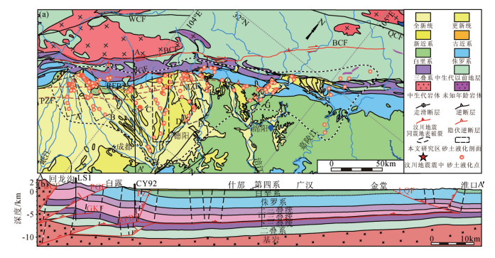
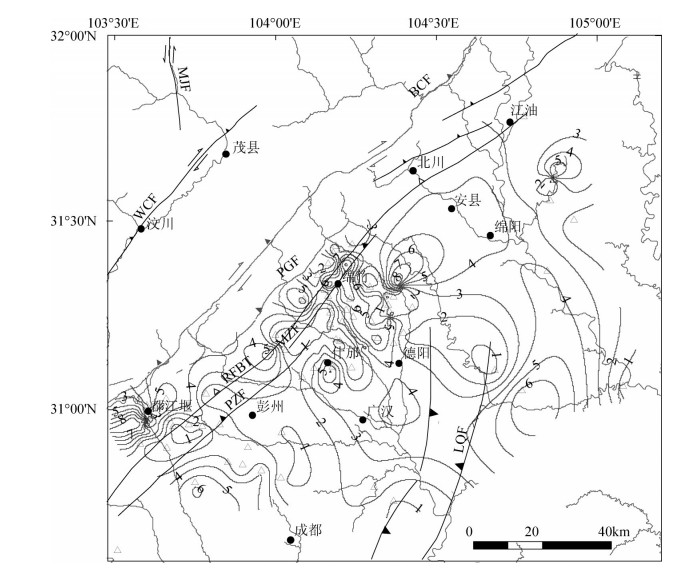
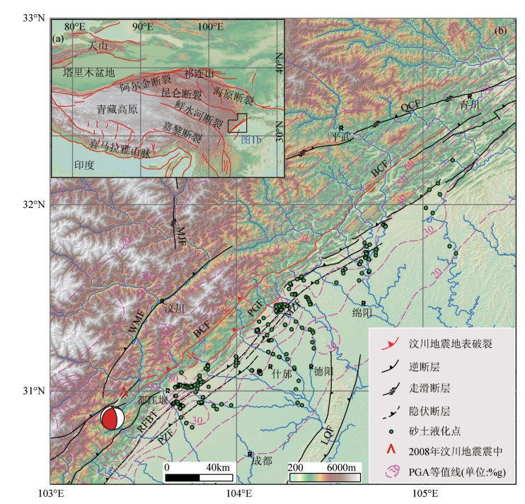
图 1 青藏高原及周边地区构造地貌、主要活动断裂图(a)和龙门山地区构造地貌与主要活动断裂图(b)
(红色实线为汶川地震同震地表破裂带[28];PGA等值线值为峰值加速度的水平分量[29])
MJF—岷江断层;QCF—青川断层;WMF—汶川-茂汶断层;BCF—北川断层;PGF—彭灌断层;RFBT—山前隐伏断层;PZF—彭州断层;MZF—绵竹断层;LQF—龙泉断层Figure 1. Topography and major active faults in and around the Tibetan Plateau (a), and topographic and tectonic map of the Longmen Mountain area (b)
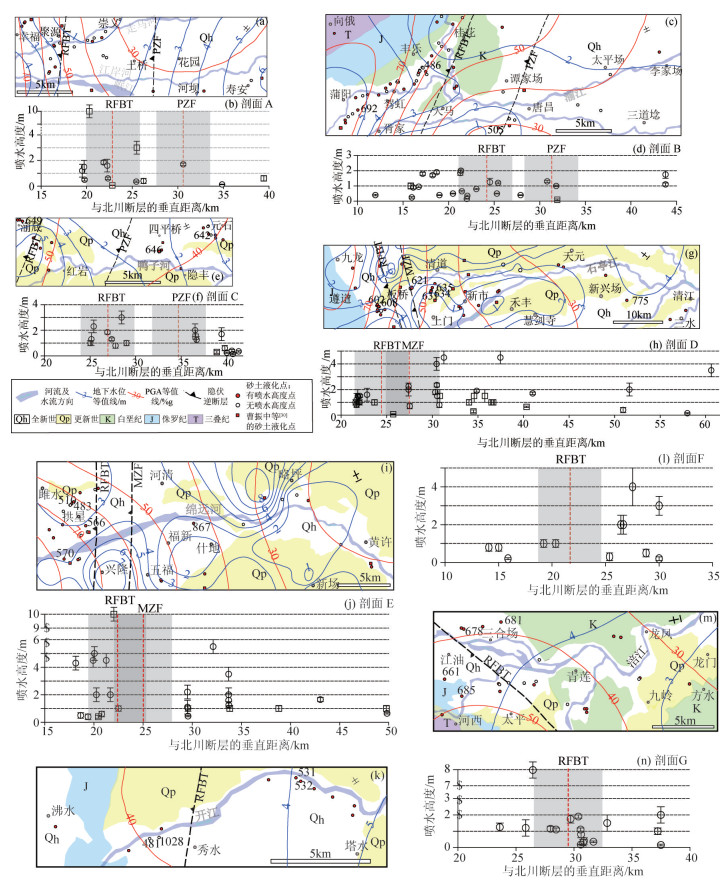
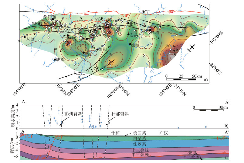
图 5 喷水高度与地下水位(a)、PGA(b)、距北川断层的垂直距离(c)关系图
(菱形代表本次研究结果,方形为曹振中等[30]的喷水高度点;同时给出砂土液化点数量统计结果直方图;图c中灰色矩形区域为山前隐伏断层(RFBT)及彭州断层(PZF))
Figure 5. Plots of water ejection height versus water table depth (a), PGA(b), and distance to the Beichuan fault (c)
-
Ambrasey N, Sarma S. Liquefaction of soils induced by earthquakes[J]. Bulletin of the Seismological Society of America, 1969, 59(2):651-664.
Ishihara K. Liquefaction and flow failure during earthquakes[J]. Geotechnique, 1993, 43(3):351-415. doi: 10.1680/geot.1993.43.3.351
Obermeier S F. Use of liquefaction-induced features for paleoseismic analysis-An overview of how seismic liquefaction features can be distinguished from other features and how their regional distribution and properties of source sediment can be used to infer the location and strength of Holocene paleo- earthquakes[J]. Engineering Geology, 1996, 44(1/4):1-76. https://www.deepdyve.com/lp/elsevier/use-of-liquefaction-induced-features-for-paleoseismic-analysis-an-WV17EeN2kL
Youd T L, Idriss I M, Andrus R D, et al. Liquefaction resistance of soils:Summary report from the 1996 NCEER and 1998 NCEER/NSF Workshops on Evaluation of Liquefaction Resistance of Soils[J]. J. Geotech Geoenviron. Eng., 2001, 127(10):817-833. doi: 10.1061/(ASCE)1090-0241(2001)127:10(817)
Wang C Y. Liquefaction beyond the Near Field[J]. Seismol. Res. Lett., 2007, 78(5):512-517. doi: 10.1785/gssrl.78.5.512
Holzer T L, Jayko A S, Hauksson E, et al. Liquefaction caused by the 2009 Olancha, California (USA), M5.2 earthquake[J]. Engineering Geology, 2010, 116(1):184-188. https://www.researchgate.net/publication/223065568_Liquefaction_caused_by_the_2009_Olancha_California_USA_M52_earthquake
Iwasaki T. Soil liquefaction studies in Japan:state of the art[J]. Soil Dynamics and Earthquake Engineering, 1986, 5(1):2-68. doi: 10.1016/0267-7261(86)90024-2
尹荣一, 刘运明, 李有利, 等.唐山地区地震液化与地貌之间的关系[J].水土保持研究, 2005, 12(4):110-112. http://www.wanfangdata.com.cn/details/detail.do?_type=degree&id=Y986918 Sims J D, Garvin C D. Recurrent liquefaction induced by the 1989 Loma Prieta earthquake and 1990 and 1991 aftershocks:implications for paleoseismicity studies[J]. Bulletin of the Seismological Society of America, 1995, 85(1):51-65. https://www.researchgate.net/publication/279567188_Recurrent_liquefaction_induced_by_the_1989_Loma_Prieta_earthquake_and_1990_and_1991_aftershocks_implications_for_paleoseismicity_studies
Holzer T L, Bennett M J, Ponti D J, et al. Liquefaction and soil failure during 1994 Northridge earthquake[J]. J. Geotech. Geoenviron. Eng., 1999, 125(6):438-452. doi: 10.1061/(ASCE)1090-0241(1999)125:6(438)
Wang C Y, Dreger D S, Wang C H, et al. Field relations among coseismic ground motion, water level change and liquefaction for the 1999 Chi-Chi (Mw=7.5) earthquake, Taiwan[J]. Geophysical Research Letters, 2003, 30(17):doi: 10.1029/2003GL017601.
Wang C Y, Wang C H, Manga M. Coseismic release of water from mountains:Evidence from the 1999(Mw=7.5) Chi-Chi, Tai-wan, earthquake[J]. Geology, 2004, 32(9):769-772. doi: 10.1130/G20753.1
Cox S, Rutter H, Sims A, et al. Hydrological effects of the MW 7.1 Darfield (Canterbury) earthquake, 4 September 2010, New Zealand[J]. New Zealand Journal of Geology and Geophysics, 2012, 55(3):231-247. doi: 10.1080/00288306.2012.680474
Quigley M C, Bastin S, Bradley B A. Recurrent liquefaction in Christchurch, New Zealand, during the Canterbury earthquake sequence[J]. Geology, 2013, 41(4):419-422. doi: 10.1130/G33944.1
Quigley M C, Hughes M W, Bradley B A, et al. The 2010-2011 Canterbury earthquake sequence:environmental effects, seismic triggering thresholds and geologic legacy[J]. Tectonophysics, 2016, 672:228-274. http://adsabs.harvard.edu/abs/2016Tectp.672..228Q
Housner G W. The mechanism of sandblows[J]. Bulletin of the Seismological Society of America, 1958, 48(2):155-161. https://www.researchgate.net/publication/285244357_The_mechanism_of_sandblows
Audemard F A, Gomez J C, Tavera H J, et al. Soil liquefaction during the Arequipa Mw 8.4, June 23, 2001 earthquake, southern coastal Peru[J]. Engineering Geology, 2005, 78(3/4):237-255.
Dobry R. Some basic aspects of soil liquefaction during earthquakes[J]. Annals of the New York Academy of Sciences, 1989, 558:172-182. doi: 10.1111/nyas.1989.558.issue-1
Obermeier S F, Dickenson S E. Liquefaction evidence for the strength of ground motions resulting from Late Holocene Cascadia subduction earthquakes, with emphasis on the event of 1700 A.D[J]. Bulletin of the Seismological Society of America, 2000, 90(4):876-896. doi: 10.1785/0119980179
Idriss I M, Boulanger R W. Semi-empirical procedures for evaluating liquefaction potential during earthquakes[J]. Soil Dynamics and Earthquake Engineering, 2006, 26(2/4):115-130. https://www.deepdyve.com/lp/elsevier/semi-empirical-procedures-for-evaluating-liquefaction-potential-during-PJUIHBP7K4
Youd T L, Hoose S N. Liquefaction susceptibility and geologic setting[C]//the Proceedings of the 6th World Conference on Earthquake Engineering, F, 1977, Indian Society of Earthquake Technology Roorkee, India, 1977.
Cao Z Z, Youd T L, Yuan X M. Gravelly soils that liquefied during 2008 Wenchuan, China earthquake, Ms=8.0[J]. Soil Dynamics and Earthquake Engineering, 2011, 31(8):1132-1143. doi: 10.1016/j.soildyn.2011.04.001
Chen L W, Yuan X M, Cao Z Z, et al. Liquefaction macrophenomena in the great Wenchuan earthquake[J]. Earthquake Engineering and Engineering Vibration, 2009, 8(2):219-229. doi: 10.1007/s11803-009-9033-4
Hou L Q, Li A F, Qiu Z M. Characteristics of Gravelly Soil Liquefaction in Wenchuan Earthquake[J]. Applied Mechanics & Materials, 2011, 90/93:1498-1502.
Huang Y, Jiang X M. Field-observed phenomena of seismic liquefaction and subsidence during the 2008 Wenchuan earthquake in China[J]. Natural hazards, 2010, 54(3):839-850. doi: 10.1007/s11069-010-9509-6
曹振中, 袁晓铭, 陈龙伟, 等.汶川大地震液化宏观现象概述[J].岩土工程学报, 2010, 32(4):645-650. http://www.oalib.com/paper/4368664 袁晓铭, 曹振中, 孙锐, 等.汶川8.0级地震液化特征初步研究[J].岩石力学与工程学报, 2009, 28(6):1288-1296. http://www.cnki.com.cn/Article/CJFDTotal-ZZFY201601008.htm Liu Z J, Zhang Z, Wen L, et al. Co-seismic ruptures of the 12 May 2008, M(s) 8.0 Wenchuan earthquake, Sichuan:East- west crustal shortening on oblique, parallel thrusts along the eastern edge of Tibet[J]. Earth Planet Sci Lett, 2009, 286(3/4):355-370.
USGS. USGS Peak Accel. Map (in%g): Wenchuan, China[EB/OL] (2017-03-13)[2017-04-12] https: //earthquake. usgs. gov/earthquakes/eventpage/usp000g650#shakemap.
曹振中, 袁晓铭.砾性土液化原理与判别技术——以汶川8.0级地震为例[M].北京:科学出版社, 2015. Li Z G, Liu Z J, Jia D, et al. Quaternary activity of the range front thrust system in the Longmen Shan piedmont, China, revealed by seismic imaging and growth strata[J]. Tectonics, 2016, 35(12):2807-2827. doi: 10.1002/2015TC004093
Jia D, Wei G Q, Chen Z X, et al. Longmen Shan fold-thrust belt and its relation to the western Sichuan Basin in central China:New insights fiom hydrocarbon exploration[J]. AAPG Bull., 2006, 90(9):1425-1447. doi: 10.1306/03230605076
Jia D, Li Y Q, Lin A M, et al. Structural model of 2008 Mw 7.9 Wenchuan earthquake in the rejuvenated Longmen Shan thrust belt, China[J]. Tectonophysics, 2010, 491(1/4):174-184. https://www.researchgate.net/publication/223793722_Structural_Model_of_2008_Mw_79_Wenchuan_Earthquake_in_the_Rejuvenated_Longmen_Shan_Thrust_Belt_China
Hubbard J, Shaw J H. Uplift of the Longmen Shan and Tibetan plateau, and the 2008 Wenchuan (M=7.9) earthquake[J]. Nature, 2009, 458(7235):194-197. doi: 10.1038/nature07837
Hubbard J, Shaw J H, Klinger Y. Structural setting of the 2008 M(w)7.9 Wenchuan, China, earthquake[J]. Bulletin of the Seismological Society of America, 2010, 100(5B):2713-2735. doi: 10.1785/0120090341
Li Y Q, Jia D, Shaw J H, et al. Structural interpretation of the coseismic faults of the Wenchuan earthquake:Three- dimensional modeling of the Longmen Shan fold-and-thrust belt[J]. J. Geophys Res-Solid Earth, 2010, 115, B04317, doi: 10.1029/2009JB006824.
Ji C, Shao G, Lu Z, et al. Rupture history of 2008 May 12 Mw 8. 0 Wen-Chuan earthquake: evidence of slip interaction[C]//2008 Fall Meeting, AGU, Eos Trans, Suppl., 2008, 89(53): S23E-02.
Liu Z J, Sun J, Wang P, et al. Surface ruptures on the transverse Xiaoyudong fault:A signifi cant segment boundary breached during the 2008 Wenchuan earthquake, China[J]. Tectonophysics, 2012, 580:218-241. doi: 10.1016/j.tecto.2012.09.024
Shao G, Ji C, Lu Z, et al. Slip History of the 2008 Mw 7. 9 Wenchuan earthquake constrained by jointly inverting seismic and geodetic observations[J]. 2010 Fall Meeting, AGU, San Francisco, Calif., 13-17 Dec. 2010, Abstract: S52B-04.
Zhang P Z, Wen X Z, Shen Z K, et al. Oblique, high-angle, listric- reverse faulting and associated development of strain:The Wenchnan earthquake of May 12, 2008, Sichuan, China[J]. Annual Review of Earth and Planetary Sciences, 2010, 38:353-382. doi: 10.1146/annurev-earth-040809-152602
Li X, Zhou Z, Yu H, et al. Strong motion observations and recordings from the great Wenchuan Earthquake[J]. Earthquake Engineering and Engineering Vibration, 2008, 7(3):235-246. doi: 10.1007/s11803-008-0892-x
Hartzell S, Mendoza C, Ramirez-Guzman L, et al. Rupture history of the 2008 Mw 7.9 Wenchuan, China, earthquake:Evaluation of separate and joint inversions of geodetic, teleseismic, and strongmotion Data[J]. Bulletin of the Seismological Society of America, 2013, 103(1):353-370. doi: 10.1785/0120120108
杨晓平, 李安, 刘保金, 等.成都平原内汶川Ms8.0级地震的地表变形[J].地球物理学报, 2009, 52(10):2527-2537. doi: 10.3969/j.issn.0001-5733.2009.10.011 刘保金, 张先康, 鄂少英, 等.龙门山山前彭州隐伏断裂高分辨率地震反射剖面[J].地球物理学报, 2009, 52(2):538-546. http://manu39.magtech.com.cn/Geophy/CN/article/downloadArticleFile.do?attachType=PDF&id=933 de Michele M, Raucoules D, de Sigoyer J, et al. Three-dimensional surface displacement of the 2008 May 12 Sichuan earthquake (China) derived from Synthetic Aperture Radar:evidence for rupture on a blind thrust[J]. Geophys. J. Int., 2010, 183(3):1097-1103. http://www.academia.edu/8282443/Three-dimensional_surface_displacement_of_the_2008_May_12_Sichuan_earthquake_China_derived_from_Synthetic_Aperture_Radar_evidence_for_rupture_on_a_blind_thrust
Sirovich L. Repetitive liquefaction at a gravelly site and liquefaction in overconsolidated sands[J]. Soils and Foundations, 1996, 36(4):23-34. doi: 10.3208/sandf.36.4_23
Kokusho T, Tanaka Y, Kawai T, et al. Case study of rock debris avalanche gravel liquefied during 1993 Hokkaido-Nansei-Oki earthquake[J]. Journal of the Japanese Geotechnical Society Soils & Foundation, 1995, 35(3):83-95. https://www.researchgate.net/publication/270924202_Case_Study_of_Rock_Debris_Avalanche_Gravel_Liquefied_during_1993_Hokkaido-Nansei-Oki_Earthquake
Hatanaka M, Uchida A, Ohara J. Liquefaction characteristics of a gravelly fill liquefied during the 1995 Hyogo-ken Nanbu earthquake[J]. Journal of the Japanese Geotechnical Society Soils & Foundation, 1997, 37(3):107-115. https://www.researchgate.net/publication/284272719_Liquefaction_Characteristics_of_a_Gravelly_Fill_Liquefied_during_the_1995_Hyogo-ken_Nanbu_Earthquake
Lin P S, Chang C W, Chang W J. Characterization of liquefaction resistance in gravelly soil:large hammer penetration test and shear wave velocity approach[J]. Soil Dynamics and Earthquake Engineering, 2004, 24(9):675-687. https://www.deepdyve.com/lp/elsevier/characterization-of-liquefaction-resistance-in-gravelly-soil-large-T0yQ78j54n
Chester F M, Logan J M. Implications for mechanical properties of brittle faults from observations of the Punchbowl fault zone, California[J]. Pure and Applied Geophysics, 1986, 124(1):79-106. doi: 10.1007/BF00875720
Chester F M, Chester F M. Ultracataclasite structure and friction processes of the Punchbowl fault, San Andreas system, California[J]. Tectonophysics, 1998, 295(295):199-221. http://www.geo.tu-freiberg.de/tektono/downloadfiles/Chester%20and%20Chester%20ultracataclastite%20SA,%20Punchbowl%20Tectonophyiscs,%20295,%201998.pdf
Ben-Zion Y, Sammis C G. Characterization of Fault Zones[J]. Pure and Applied Geophysics, 2003, 160(3):677-715. doi: 10.1007/PL00012554
Donati S, Marra F, Rovelli A. Damage and ground shaking in the town of Nocera Umbra during Umbria-Marche, central Italy, earthquakes:The special effect of a fault zone[J]. Bulletin of the Seismological Society of America, 2001, 91(3):511-519. doi: 10.1785/0120000114
Marra F, Azzara R, Bellucci F, et al. Large amplification of ground motion at rock sites within a fault zone in Nocera Umbra (central Italy)[J]. J. Seismol., 2000, 4(4):543-554. doi: 10.1023/A:1026559901378
Rovelli A, Caserta A, Marra F, et al. Can seismic waves be trapped inside an inactive fault zone? The case study of Nocera Umbra, Central Italy[J]. Bulletin of the Seismological Society of America, 2002, 92(6):2217-2232. doi: 10.1785/0120010288
Spudich P, Olsen K B. Fault zone amplified waves as a possible seismic hazard along the Calaveras fault in central California[J]. Geophysical Research Letters, 2001, 28(13):2533-2536. doi: 10.1029/2000GL011902
Li Y G, Leary P, Aki K, et al. Seismic trapped modes in the Oroville and San Andreas fault zones[J]. Science, 1990, 249(4970):763-766. doi: 10.1126/science.249.4970.763
Li Y G, Leary P C. Fault zone trapped seismic wave[J]. Bulletin of the Seismological Society of America, 1990, 80(5):1245-1271. http://ci.nii.ac.jp/naid/80005544850
Li Y G, Vidale J E, Cochran E S. Low-velocity damaged structure of the San Andreas Fault at Parkfield from fault zone trapped waves[J]. Geophysical Research Letters, 2004, 31(12):doi: 10.1029/2003GL019044.


 下载:
下载:
