The development characteristics of surface fracture and secondary hazards at 5·22 Ms 7.4 earthquake in Maduo County Qinghai Province
-
摘要:
2021年5月22日2时04分在青海省果洛藏族自治州玛多县发生7.4级地震,为了查明此次地震产生的地表破裂和伴生次生灾害发育特征,调查组采用遥感解译和实地调查方式对地震影响区进行了调查。调查结果显示,在玛多-甘德断裂和昆仑山口-江错断裂之间形成了一条宽约75km、长约230km的活动断裂带,地表新发现地裂缝653条、砂土液化和喷砂冒水点1237个、地震鼓包97个、塌陷坑2个。地表破裂总体呈北西—南东向展布,自西向东出现马尾状分支的现象,东段与玛多-甘德断裂带以一定角度斜交,地裂缝整体走向与昆仑山口-江错断裂走向高度一致。地震地表破裂发育特征显示,此次玛多Ms7.4级地震的发震断裂为昆仑山口-江错断裂,断面整体南倾,性质为左行走滑。此次大地震的发生是在印度板块向青藏高原挤压背景下,巴颜喀拉地块强烈向东挤出构造作用导致其北部走滑断裂发生左旋运动的结果。调查结果为地方政府关于灾区地震灾害损失评估及灾后重建提供了第一手基础资料。
Abstract:At 2:04 on May 22,2021, an earthquake of magnitude 7.4 occurred in Maduo County,Guoluo Tibetan Autonomous Prefecture,Qinghai Province. In order to find out the characteristics of the surface rupture and associated secondary hazards caused by the earthquake,the survey team conducted surveys in the earthquake-affected area by means of remote sensing interpretation and field survey. The survey results showed that an active fault zone with a width of about 75 km and a length of about 230 km was formed between the Maduo-Gande fault and the Kunlun Mountain Pass-Jiangcuo fault; 653 ground fissures,1237 sand liquefaction and sand emitting,water spraying points,97 earthquake bulges and 2 collapse pits were found on the surface. The surface fractures were generally distributed in the north west -south east direction,with horsetail-like branches from west to east; the eastern section was oblique to the Maduo-Gande fault zone at a certain angle. The overall trend of the ground fractures was highly consistent with that of the Kunlun Mountain Pass-Jiangcuo fault. As indicated by the development characteristics of the earthquake surface fracture,the seismogenic fault of the Maduo Ms7.4 earthquake was Kunlun Mountain Pass-Jiangcuo fault,and the fault surface was generally inclined to the south,which featured left strike slip. As the earthquake broke out amid extrusion towards the Qinghai Tibet Plateau by the Indian Plate,the earthquake resulted from sinistral movement at strike-slip fault in the north under the tectonic action of strong eastward extrusion by Bayan Har block. The survey results provide the local government with first-hand basic information on the earthquake disaster loss assessment and post-disaster reconstruction in the disaster area.
-
2021年5月22日凌晨2时04分,青海省果洛州玛多县黄河乡发生了7.4级地震,震源深度17 km,该地震发生在青藏高原巴颜喀拉地块东北部前人发现的全新世活断层,即昆仑山口-江错断裂带附近(张裕明等,1996;邓起东等,2002;2007)。青藏高原是中国最主要的地震活动区,尤其是青藏高原中部的巴颜喀拉块体周缘,近20年来发生了一系列强震事件,显示其构造运动正处于活跃期(程佳等,1997;闻学泽等,2011;Jia et al., 2012;徐锡伟等,2017)。巴颜喀拉地块位于青藏高原中北部,该地块呈西部狭长、东侧张开的倒三角形,北侧、西南侧、东南侧分别为柴达木-西秦岭褶皱带、羌塘地块和四川盆地(Meyer et al., 1998;张培震等,2003;徐锡伟等,2008;嘉世旭等,2017)。巴颜喀拉地块的现今运动主要受控于周边的大型活动断裂带,其北边界为昆仑断裂带(Kirby et al., 2000;杜方等,2013),东边界为兼右旋走滑分量的龙门山逆冲断裂(徐锡伟等,2002),南边界为玉树-鲜水河断裂带。作为南北地震带中段的重要组成部分,巴颜喀拉地块东缘现今的地震活动强烈,历史上曾发生过多次强震(许志琴等,1992;Densmore et al., 2007;邓起东等,2010;孟宪纲等,2014;杜方等,2018)。自21世纪初开始,沿巴颜喀拉地块边界又相继发生了多次强震,如2001年昆仑山口西Ms8.1地震、2008年汶川Ms8.0地震、2010年玉树Ms7.1地震和2013年芦山Ms7.0地震、2017年九寨沟Ms7.0地震。此次玛多7.4级地震的发生,表明目前巴颜喀拉块体仍然是中国大陆强震的主体活动地区之一。
玛多地震后,多家单位迅速组织了科考队奔赴现场,进行现场地震断层与次生灾害等的科学考察,在震中区一带先后发现了同震地表裂缝与伴生的地震地质灾害。笔者在玛多地震发生之后的第一时间,收集了玛多周边区域及地质构造、卫星遥感影像等资料,并沿此次地震的发震断裂昆仑山-江错断裂带进行了地震地表破裂与伴生次生灾害等的地表调查。本文主要对本次调查的结果进行介绍,并对相关问题进行讨论。
1. 区域地质背景
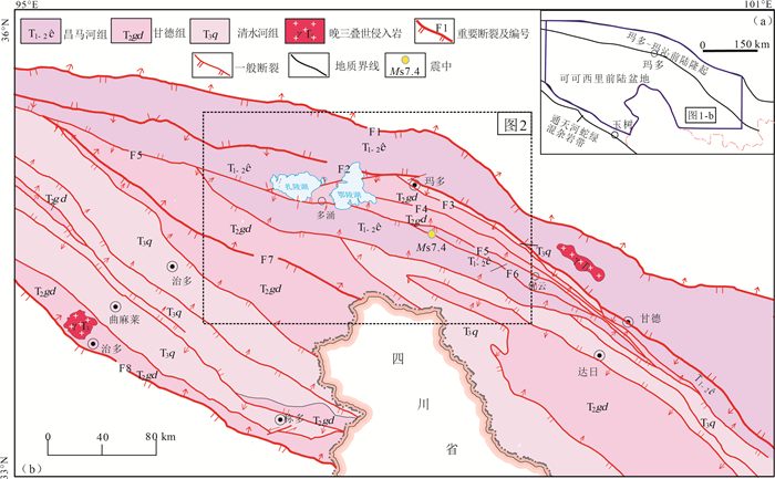
此次大地震发生区域在大地构造上隶属于北羌塘-三江造山系巴颜喀拉地块可可西里前陆盆地(图 1-a)。该前陆盆地呈北西西向展布于可可西里—巴颜喀拉一带,夹持于东昆仑断裂及可可西里南缘断裂之间。
研究区出露地层主要为巴颜喀拉山群昌马河组(T1-2č)、甘德组(T2gd)和清水河组(T3q), 另外在黄河流域及其支流第四纪沉积物广泛发育,类型有洪积物、冲积、风积、湖积等,而此次地震形成的地裂缝、砂土液化点、地震鼓包等均在第四系地质体中表现的更直观。区内有少量岩浆活动,在扎日加至东端的年宝玉则地区呈小岩株出露。
研究区断裂构造较发育,从北至南主要断裂有8条,分别为布青山南缘断裂(F1)、玛多-甘德断裂(F2)、玛曲-多确山断裂(F3)、卡木卡断裂(F4)、昆仑山口-江错断裂(F5)、甘德南缘断裂(F6)、卡巴纽尔多-鲜水河断裂(F7)、可可西里南缘断裂(F8)(图 1-b),其中F2-6断裂本次地震活动性明显。
玛多-甘德断裂西始昆仑山口西,经鄂陵湖北、玛多、甘德北延入甘肃,整体走向北西、倾向北东,呈向北东微凸的弧形,省内出露长度约780 km。地球物理资料反映,断裂切割深度为15 km,属韧-脆性壳型断裂,具多期活动特征。
昆仑山口-江错断裂西始昆仑山口西,经鄂陵湖南、玛多南部等地,向东延至甘德北,整体走向北西西、倾向南,为韧-脆性壳型断裂。该断层具有多期活动性,早期为浅—表部构造的逆冲推覆性质,后期为左行走滑,是一条区域性的地震活动带,2000年昆仑山口西8.1级地震带分布于该断裂带的西段(张裕明等,1996)。
玛曲-多确山断裂沿北西向延伸约76 km,倾向和倾角不明。沿断裂带水系发育,并呈直角状转弯,形成现代长垣状洼地,上游黄河干流经过,近代地震频繁发生,南侧平行排列的姊妹湖与负主断裂活动派生出羽状裂隙有关。断裂形成于中晚印支期,后期有复活。推测为隐伏正断层。
甘德南缘断裂区内出露长约60 km,断线走向北西,沿走向两端延伸迹象不明,倾角不明,性质可能为正断层。断层不仅切割下三叠统砂岩组,还控制中更新统冲洪积层及全新统风成砂的展布。北东侧为垄状、新月状砂丘,一直在活动,南西侧为已固定的风成砂堆积滩地及冲洪积层平地。沿断层线有断头河、湖泊呈线状排列等现象。断层可能形成于喜马拉雅期,现今活动性十分明显。
2. 地表破裂与次生灾害发育特征
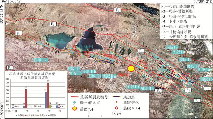
本次工作针对玛多及周边地震区活动性断裂特征开展了遥感解译(刘文等,2021)和野外现场调查,截止2021年5月30日,在宽约75 km、长约230 km的调查区内,分别对玛多-甘德断裂(F2)、玛曲-多确山断裂(F3)、卡木卡断裂(F4)、昆仑山口-江错断裂(F5)、甘德南缘断裂(F6)5条活动断裂进行了定位调查,并在上述断裂地表新发现地裂缝653条、砂土液化和喷砂冒水点1237个、地震鼓包97个、塌陷坑2个(图 2)。
(1) 玛多-甘德断裂(F2)
该断裂为玛多-玛沁前陆隆起与可可西里前陆盆地的分界断裂,整体为走向北西向、向北微凸的弧形。本次在优云乡周边地区对该断裂活动性进行了调查。
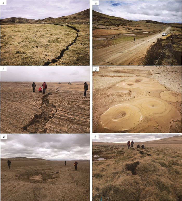
该断裂呈北西向展布,断裂上、下盘地表均被第四系冲洪积物、风积物覆盖,局部表层草皮覆盖厚,断面产状难以判断。沿断裂处及周边地表发现不同规模的地裂缝共计35条(图版Ⅰ-a、b)。地裂缝依据走向大至可分成2组,第一组地裂缝走向在90°~150°之间,整体与断裂走向一致,地裂缝宽0.5~35 m,可见延伸15~300 m。第二组地裂缝与断裂走向近正交,走向在0°~40°之间,规模较小,宽0.4~12 m,可见延伸16~40 m。
(2) 玛曲-多确山断裂(F3)
本次在斗格恰-东葛纳青玛地区对该条断裂活动性进行了调查,共发现地裂缝75条、砂土液化和喷砂冒水点约522个、地震鼓包5个及塌陷坑2个。
地裂缝依据走向大致可分为2组:第一组地裂缝呈北西西—近东西向展布,走向为90°~150°,地裂缝宽0.15~300 m,长50~2200 m,个别地裂缝断续延伸大于5 km(图版Ⅰ-c);第二组地裂缝呈近南北—北东向展布,走向0°~60°,宽15.8~70 m,延伸280~850 m。
砂土液化和喷砂冒水点大多呈串珠状定向分布(图版Ⅰ-d),大小不等,单个砂土液化和喷砂冒水点大小在(2×4) cm~(90×50) cm之间。走向与地裂缝走向较一致,同样可根据砂土液化和喷砂冒水点展布方向分为2组。第一组走向在80°~150°之间,第二组走向在0~55°之间。
地震活动造成地面沉降,形成2处塌陷坑(图版Ⅰ-e),塌陷坑长轴走向均为130°,大小在(11.6×23)~(14.6×31.1) m之间,深0.85~1.2 m。
地震鼓包仅分布于D059点处,呈串珠状展布,走向181°,单个地震鼓包大小(15×8)~(30×45) cm,鼓包凸起高度10~20 cm,鼓包深度在10~25 cm之间(图版Ⅰ-f)。
(3) 卡木卡断裂(F4)
本次在卡格龙波格地区针对卡木卡断裂活动性开展了调查,共发现地裂缝12条。根据地裂缝走向可分为北西西向和北东—南西向2组,其中北西西向地裂缝走向为110°,整体宽约30 m、长约760 m、深0.5~0.9 m,北东—南西向地裂缝走向在236°~242°之间,宽50~100 m,长490~600 m,深0.1~0.9 m。
(4) 昆仑山口-江错断裂(F5)
本次沿扎陵湖南、多涌、鄂陵湖南、野马滩、黑河乡(玛查理镇)星星海、同布岗地区对该断裂活动性开展了调查,共发现地裂缝451条、砂土液化和喷砂冒水点688个、地震鼓包92个。
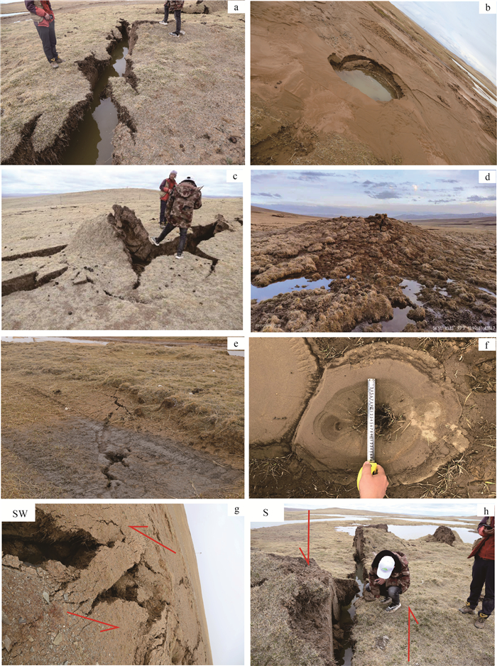
地裂缝依据走向可分为3组:第一组地裂缝整体呈近东西向或北西—南东向展布,走向在80°~140°之间,宽0.01~25 m,局部形成裂缝带宽达780 m,长0.3~500 m之间,个别地裂缝长达800 m,深0.12~1.5 m;第二组地裂缝呈北西—南东向或近南北向展布,裂缝走向320~350°,裂缝宽0.05~60 m,延伸在4~60 m之间,个别地裂缝长达800 m,深0.05~0.9 m;第三组地裂缝呈北东向展布,走向在30°~55°之间,裂缝宽0.7~5 m,延伸在35~500 m之间,深0.15~0.8 m(图版Ⅱ-a)。
砂土液化和喷砂冒水点多呈串珠状定向排列,绝大多数与近东西向或北西向地裂缝对应产出,走向以100°~120°之间居多,仅个别砂土液化和喷砂冒水点走向为10°或140°。单个砂土液化和喷砂冒水点大小在(0.01×0.06) m~(1.3×1.8) m之间,深0.03~0.6 m (图版Ⅱ-b)。
地震鼓包均沿北西—南东向地裂缝产出,其长轴走向在150°~160°之间,长轴在1.2~24 m之间,短轴在0.7~15 m之间(图版Ⅱ-c、d)。
(5) 甘德南缘断裂(F6)
西起哈日尼让马,经歇日科向南东延伸至地列一带,整体呈北西向展布,断层走向138°。断层上盘为活动风尘砂堆积、下盘为固定风尘砂及下—中三叠统昌马河组,断面北倾。断层沿线发育地裂缝、串珠状砂土液化和喷砂冒水点,断层活动性较为明显。
本次在歇日科地区共发现地裂缝80条、砂土液化和喷砂冒水点27个。其中地裂缝整体沿北西—南东向展布,地裂缝走向在110°~145°之间,宽0.3~ 100 m,宽2~650m之间,深0.02~0.4 m之间(图版Ⅱ-e)。砂土液化和喷砂冒水点整体沿地裂缝呈串珠状发育,走向120°~125°之间,其中单个砂土液化点大小在2×3cm~5×10cm之间,可见深度在10~15 cm之间(图版Ⅱ-f)。
3. 地震成因
据中国地震局网资料,本次玛多地震Ms7.4地震及余震集中分布于玛多-甘德断裂(F2)和昆仑山口-江错断裂(F5)之间。野外调查资料显示,在玛多-甘德断裂(F2)和昆仑山口-江错断裂(F5)之间,地表形成集中分布的地裂缝、砂土液化和喷砂冒水点、地震鼓包、塌陷坑等地质现象,由此判断,以F2和F5为界在区域上形成了一条宽约75 km、长约230 km的活动断裂带,其中玛曲-多确山断裂(F3)、卡木卡断裂(F4)、歇日科断裂(F6)断裂规模较小,属于该断裂带的次一级断裂。
玛多Ms7.4震源位置位于昆仑山口-江错断裂南侧,依据图 2中地裂缝、砂土液化和喷砂冒水点、地震鼓包及断裂带的空间展布特征分析,653条地裂缝总体呈北西—南东向展布,在西北段集中分布于鄂陵湖南侧,中段逐渐向玛曲、歇日科等地分散,而最东段分散更明显,在昌马河—优云乡一带均有发育,表明发震断层出现马尾状分支的现象;另外,在昌马河一带发育的地裂缝与玛多-甘德断裂带以一定角度斜交,地裂缝整体的走向与昆仑山口-江错断裂走向高度一致。因此认为,昆仑山口-江错断裂是本次强震的主要发震断层,断面整体南倾,性质为左旋走滑(图版Ⅱ-g、h)。
发震区位于巴颜喀拉地块,是夹持于北侧阿尼玛卿洋和南侧西金乌兰洋演化过程中的块体。自65 Ma以来,印度地块和塔里木地块以更大的应力向青藏高原挤压、俯冲,使高原大幅度抬升并经历了由“青藏运动序幕”、“青藏运动主幕”、“昆黄运动”及“共和运动”构成的剧烈、多幕次、后期显著加速的造山作用(李吉均等,1979;2015;崔之久等,1998;戴霜等,2005;张克信等,2013)。前人研究表明,巴颜喀拉地块东北部以块体挤压为主,东昆仑断裂带的滑动速率向东逐渐减小,意味着巴颜喀拉地块东部存在较强的内部变形。伴随青藏高原块体运动,青藏高原7级以上强震主要沿大型块体边界断裂带分布(邓起东等,2002;张培震等,2003),当块体前缘受到相对坚硬的盆地阻挡,板块内部会发生差异变形,形成一系列与边界性质相同的断裂并发生强震活动,玛多Ms7.4地震在此背景下发生。
4. 结论
(1) 在玛多县及周边宽约75 km、长约230 km的调查区内,共发现地裂缝653条、砂土液化和喷砂冒水点1237个、地震鼓包97个和塌陷坑2个。其分布特征显示:按走向可分为3组,分别为北西—南东(110°~130°)向、北东—南西(30°~55°)和北北西—南南东(320°~350°)向,主体以北西—南东为主,且形成时期最早(另2组有横切它的现象)、规模最大、地表延伸最长。
(2) 玛多地震地表破裂与独特次生灾害在西北段鄂陵湖南侧集中分布,于中段黄河乡一带逐渐向玛曲、歇日科等地分散,而最东段在昌马河—优云乡一带均有发育,分散最明显,表明发震断层出现马尾状分支的现象;在昌马河一带发育的地裂缝与玛多-甘德断裂带以一定角度斜交。
(3) 青海玛多“5.22 Ms7.4地震”的发震断裂为昆仑山口-江错断裂带(F5),断面整体南倾,性质为左旋走滑。此次大地震的发生是在印度板块向青藏高原挤压背景下,巴颜喀拉地块强烈向东挤出构造作用导致其北部走滑断裂发生左旋运动的结果。
致谢: 感谢审稿专家在论文评审过程中提出的宝贵修改意见;野外工作得到果洛州自然资源局、玛多县自然资源局的大力支持, 在此一并表示感谢。 -
-
Densmore A L, Ellis M A, Li Y, et al. Active tectonics of the Beichuan and Pengguan faults at the eastern margin of the Tibetan Plateau[J]. Tectonics, 2007, 26(4): TC4005.
Jia K, Zhou S Y, Wang R. Stress interactions within the strong earthquake sequence from 2001 to 2010 in the Bayankala block of eastern Tibet[J]. Bull. Seismol. Soc. Am., 2012, 102(5): 2157-2164. doi: 10.1785/0120110333
Kirby E, Whipple K X, Burchfiel B C, et al. Neotectonics of the Min Shan, China: Implications for mechanisms driving Quaternary deformation along the eastern margin of the Tibetan Plateau[J]. Geol. Soc Am Bull., 2000, 112(3): 375-393. doi: 10.1130/0016-7606(2000)112<375:NOTMSC>2.0.CO;2
Meyer B, Tapponnier P, Bourjot L, et al. Crustal thickening in Gansu-Qinghai, lithospheric mantle subduction, and oblique, strike-slip controlled growth of the Tibet Plateau[J]. Geophys J. Int., 1998, 135(1): 1-47. doi: 10.1046/j.1365-246X.1998.00567.x
程佳, 刘杰, 甘卫军, 等. 1997年以来巴颜喀拉块体周缘强震之间的黏弹性触发研究[J]. 地球物理学报, 2011, 54(8): 1997-2010. doi: 10.3969/j.issn.0001-5733.2011.08.007 崔之久, 伍永秋, 刘耕年, 等. 关于"昆仑-黄河运动"[J]. 中国科学(D辑), 1998, 28: 53-59. doi: 10.3321/j.issn:1006-9267.1998.01.007 戴霜, 方小敏, 宋春晖, 等. 青藏高原北部的早期隆升[J]. 科学通报, 2005, 50: 673-683. doi: 10.3321/j.issn:0023-074X.2005.07.011 邓起东, 张培震, 冉勇康, 等. 中国活动构造基本特征[J]. 中国科学(D辑), 2002, 32: 1020-1030. https://www.cnki.com.cn/Article/CJFDTOTAL-JDXK200212006.htm 邓起东, 张培震, 冉勇康, 等. 中国活动构造图(1: 400万)[M]. 北京: 地震出版社, 2007. 邓起东, 高翔, 陈桂华, 等. 青藏高原昆仑-汶川地震系列与巴颜喀喇断块的最新活动[J]. 地学前缘, 2010, 17(5): 163-178. https://www.cnki.com.cn/Article/CJFDTOTAL-DXQY201005017.htm 杜方, 龙锋, 阮祥, 等. 四川芦山7.0级地震及其与汶川8.0级地震的关系[J]. 地球物理学报, 2013, 56(5): 1772-1783. https://www.cnki.com.cn/Article/CJFDTOTAL-DQWX201305036.htm 杜方, 闻学泽, 冯建刚, 等. 六盘山断裂带的地震构造特征与强震危险背景[J]. 地球物理学报, 2018, 61(2): 545-559. https://www.cnki.com.cn/Article/CJFDTOTAL-DQWX201802014.htm 嘉世旭, 林吉焱, 郭文斌, 等. 巴颜喀拉块体地壳结构多样性探测[J]. 地球物理学报, 2017, 60(6): 2226-2238. https://www.cnki.com.cn/Article/CJFDTOTAL-DQWX201706017.htm 李吉均, 文世宣, 张青松, 等. 青藏高原隆起的时代、幅度和形式的探讨[J]. 中国科学(A辑), 1979, 9: 608-616. https://www.cnki.com.cn/Article/CJFDTOTAL-JAXK197906008.htm 李吉均, 周尚哲, 赵志军, 等. 论青藏运动主幕[J]. 中国科学(D辑), 2015, 45(10): 1597-1608. https://www.cnki.com.cn/Article/CJFDTOTAL-JDXK201510015.htm 刘文, 王猛, 朱赛楠, 等. 基于光学遥感技术的高山极高山区高位地质灾害链式特征分析——以金沙江上游典型堵江滑坡为例[J]. 中国地质灾害与防治学报, 2021, 32(5): 29-39. https://www.cnki.com.cn/Article/CJFDTOTAL-ZGDH202105004.htm 孟宪纲, 薄万举, 刘志广, 等. 芦山7.0级地震与巴颜喀拉块体中东段的活动性[J]. 吉林大学学报(地球科学版), 2014, 44(5): 1705-1711. https://www.cnki.com.cn/Article/CJFDTOTAL-CCDZ201405032.htm 闻学泽, 杜方, 张培震, 等. 巴颜喀拉块体北和东边界大地震序列的关联性与2008年汶川地震[J]. 地球物理学报, 2011, 54(3): 706-716. https://www.cnki.com.cn/Article/CJFDTOTAL-DQWX201103011.htm 徐锡伟, 陈桂华, 王启欣, 等. 九寨沟地震发震断层属性及青藏高原东南缘现今应变状态讨论[J]. 地球物理学报, 2017, 60(10): 4018-4026. https://www.cnki.com.cn/Article/CJFDTOTAL-DQWX201710028.htm 徐锡伟, 闻学泽, 陈桂华, 等. 巴颜喀拉地块东部龙日坝断裂带的发现及其大地构造意义[J]. 地震学报, 2008, 38(5): 529-542. https://www.cnki.com.cn/Article/CJFDTOTAL-JDXK200805001.htm 徐锡伟, 陈文彬, 于贵华, 等. 2001年11月14日昆仑山库赛湖地震(Ms8.1)地表破裂带的基本特征[J]. 地震地质, 2002, 24(1): 1-13. https://www.cnki.com.cn/Article/CJFDTOTAL-DZDZ200201000.htm 许志琴, 侯立伟, 王宗秀, 等. 松潘-甘孜造山带的造山过程[M]. 北京: 地质出版社, 1992. 张克信, 王国灿, 洪汉烈, 等. 青藏高原新生代隆升研究现状[J]. 地质通报, 2013, 32(1): 1-18. http://dzhtb.cgs.cn/gbc/ch/reader/view_abstract.aspx?file_no=20130101&flag=1 张培震, 邓起东, 张国民, 等. 中国大陆的强震活动与活动地块[J]. 中国科学(D辑), 2003, 33(增刊1): 12-20. https://www.cnki.com.cn/Article/CJFDTOTAL-JDXK2003S1001.htm 张裕明, 李闽峰, 孟勇琦, 等. 巴颜喀拉山地区断层活动性研究及其地震地质意义[M]. 北京: 地震出版社, 1996. -
期刊类型引用(3)
1. 孟思晨,孟秋,陈启志,胡才博. 2021年5月22日青海玛多M_S7.4地震同震变形的数值模拟及其动力学启示. 中国科学院大学学报. 2024(01): 70-80 .  百度学术
百度学术
2. 刘传正,梁宽,王秀英. 积石山M_s6.2级地震区大沙沟泥土流灾害链成因分析. 地质论评. 2024(03): 960-974 .  百度学术
百度学术
3. 王博,崔凤珍,刘静,周永胜,徐胜,邵延秀. 玛多M_S7.4地震断层土壤气特征与地表破裂的相关性. 地震地质. 2023(03): 772-794 .  百度学术
百度学术
其他类型引用(1)


 下载:
下载:


