Application of airborne transient electromagnetic method in the delineation of aquifer stratum in Balinzuoqi, Inner Mongolia
-
摘要:
巴林左旗是内蒙古赤峰的典型缺水区域,水资源的匮乏制约了地区的农牧业发展,圈定含水地层对本区具有重要意义。为了实现地下水增储,使用直升机瞬变电磁法,勘探本区地下水资源。在工作中对航空瞬变电磁数据进行视电阻率-深度计算,dB/dT感应电动势分析,衰减曲线特征分类,最终圈定本区含水地质体,给出了含水地层平面及空间展布特征。推断本地区地下含水层顶面主要埋深在10~30 m,含水层厚度30~80 m,全区共有地下水储量约4.54×10⁶ t。航空瞬变电磁法在本地区找水方面取得了较好的效果,在水文地质勘查方面具有很大前景。
Abstract:Balinzuoqi is a typical water-deficient area in Chifeng, Inner Mongolia, where the scarcity of water resources restricts the development of regional agriculture and animal husbandry.Identifying aquifer stratum is of great significance to this area.In order to increase the storage of groundwater, the helicopter airborne transient electromagnetic method was used in May 2019 to explore groundwater resources in this area.In the work, the resistivity conversion of the airborne transient electromagnetic data, analysis of the dB/dT induced electromotive force and classification of the attenuation curve were performed to finally delineate the water-bearing geological body in the area, which resulted in the plane and spatial distribution characteristics of the water-bearing formation.It is inferred that the top surface of the underground aquifer in this area is mainly buried at the depth of 10 m to 30 m, the thickness of the aquifer ranges from 30 m to 80 m, and the total underground water reserve in the whole area is about 4.54×10⁶ tons.The airborne transient electromagnetic method has achieved agreeable results in water prospecting in this area and has great prospects in hydrogeological survey.
-
巴林左旗地处内蒙古自治区赤峰市北部,全旗基本没有境外水源或其他水源,补给源来自大气降水,水资源总量为3.0375×10⁸ m3[1],总人口35.9万人,人均补给水资源占有量仅846.1 m3,是全国人均占有量的40%,按照国际公认标准,人均占有量低于1000 m3,属重度缺水区。从水资源分区看,全旗90%的土地面积集中于乌尔吉沐伦河流域,地表水开发利用率较高,而地下水开采率仅为40.25%。巴林左旗是一个以农牧业为主的经济区,探明区域地下水分布情况,提高地下水资源利用率,对农业发展和生态环境保护具有重要意义[1-2]。
时间域电磁法(Time domain electromagnetic methods, TEM)或称瞬变电磁法(Transient electromagnetic methods, TEM),是在地面或空中布设通过一定波形电流的线圈,向地下发射一次脉冲磁场,在一次脉冲磁场的关断间歇期间利用接收线圈观测物体引起的二次感应涡流场,获得物体的电阻率信息[3-4]。TEM提供了一种工作效率高、分辨能力强、可用较小装置实现较大深度地下资源勘查的有效工具,被称为“水源勘查的锐利武器”[5]。TEM存在多种工作形式,包括井中TEM、地面TEM、地空TEM及航空TEM。航空TEM因机动灵活、分辨率高、工作效率高、覆盖面积大、适应地形能力强等特点,广泛应用于大面积范围内快速勘查地下水资源。目前,航空TEM在地质勘查领域发挥着重要的作用,有逐渐替代地面TEM系统的趋势[6-8]。Masrom等[9]应用航空瞬变电磁技术在丹麦奥胡斯县探测到位于第四系内的地下河谷,Hesham等[10]利用航空瞬变电磁技术调查了北阿曼-沿海冲击含水层的海水入侵程度,何怡原等[11]应用航空瞬变电磁技术调查了宝清地区含水体的分布。
本文采用中国自然资源航空物探遥感中心自主研发的CHTEM-Ⅱ系统在内蒙古赤峰巴林左旗富河镇地区开展航空瞬变电磁测量,通过视电阻率换算,得到电阻率-深度剖面及电阻率平面分布图,结合多条剖面的视电阻率换算结果,以及异常衰减曲线特征、dB/dT感应电动势变化规律,得到区内地下含水层分布的空间展布特征,与当地水文资料结果基本一致。
1. 区域地质概况与地球物理特征
内蒙古巴林左旗一级构造单元为华北板块或塔里木-华北板块(Ⅱ),二级构造单元为华北板块北部大陆边缘或天山-赤峰活动带(Ⅱ1),三级构造单元为宝音图-锡林浩特火山型被动陆缘(Ⅱ11),四级构造单元为乌兰浩特-林西晚古生代裂谷带(Ⅱ11-3)。研究区位于乌兰浩特-林西晚古生代裂谷带的中南部,与开鲁-通辽中新生代盆地相邻。由于太平洋板块向西伯利亚板块和华北板块的俯冲挤压作用,在研究区及区域上有NE—NNE向板内造山带-大兴安岭-太行山中生代构造岩浆岩带(或隆起带)叠加其上[12-13]。
内蒙古巴林左旗富河镇地区水系不发育,仅有乌尔吉沐伦河及其支流,是区内常年流水的主要河流,由北向南从研究区的中部流过,注入西拉木伦河后进入辽河,地下水缺少接受地表水补给的条件,因此区域地下水的主要补给来源为大气降水和地下水的迳流补给。由于地貌、构造、岩性等条件不同,地下水补给、迳流、排泄条件也不同[14-16]。
含水层主要为第四系松散岩类孔隙潜水含水层和基岩裂隙含水层,二者之间有密切的水力联系,其特征为:①松散岩类孔隙潜水,第四系全新统—上更新统坡洪积砂碎石、冲洪积砂砾石孔隙潜水含水岩组,含水层分布在沟谷洼地和河谷平原,由土黄色、灰黄色砂、砂砾石组成。据富河镇当地水井资料,含水层厚度一般为30~80 m,水位埋深一般为10~80 m,富水性中等。②基岩裂隙水基岩裂隙潜水普遍分布在低山丘岭区。含水层由各期侵入岩体、变质岩、火山岩和沉积岩的裂隙构成,裂隙较发育,普遍含水,但埋藏分布极不均匀,富水性弱,受构造影响,局部可能出现较大的基岩裂隙潜水。
通过对野外采集的岩石标本和钻孔岩心进行物性测量,建立内蒙古赤峰巴林左旗地区地层岩性与电阻率对照表(表 1)。区内第四系坡积物、洪积物砂砾石的视电阻率最低,次为泥岩、砂岩、凝灰岩、板岩等,岩浆岩的视电阻率较高。应用航空瞬变电磁法主要探测的含水层为电阻率较低的全新统—上更新统坡洪积砂碎石、冲洪积砂砾石,由于电阻率的差异,含水层与底部二叠系大石寨组泥岩、粉砂岩、板岩或玛尼吐组玻屑凝灰岩组成的隔水层具有明显的分界线。
表 1 巴林左旗地区岩(矿)石电阻率Table 1. Resistivity for different lithology in Balinzuoqi area岩石名称 电阻率最大值/(Ω·m) 电阻率最小值/(Ω·m) 电阻率均值/(Ω·m) 第四系坡积物 103 44 75 第四系洪积物 93 25 53 凝灰岩 1237 1799 1518 安山岩 1953 3431 2805 板岩 970 1711 1436 粉砂岩 443 1258 998 泥岩 216 963 503 变质粉砂岩 1589 4207 3374 辉绿岩 5558 7610 6825 花岗岩 2857 3962 3442 磁铁矿 1462 4845 2215 银多金属矿石 107 481 331 2. 航空瞬变电磁数据采集与处理
2.1 航空TEM测线布置
本次航空瞬变电磁测量工作使用的是小松鼠B3E型直升机,使用的设备为由中国自然资源航空物探遥感中心自主研发的CHTEM-Ⅱ型直升机时间域航空电磁勘查系统。CHTEM-Ⅱ直升机时间域航空电磁勘查系统集成了航空电磁数据采集、GPS定位数据采集、雷达高度计数据采集等功能。此外,该系统还集成了CS3型铯光泵磁力仪,用于同步收录航磁数据。
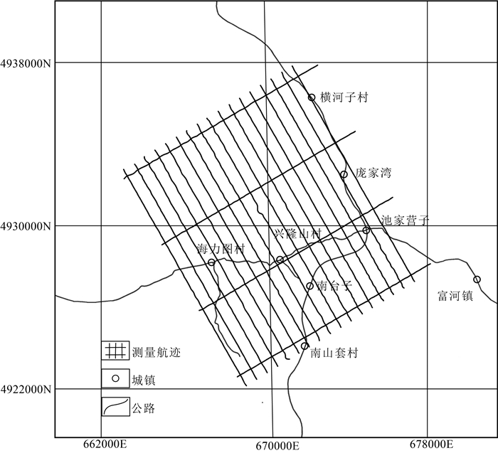
研究区主要构造走向为NE向和NNE向,按照测线尽量垂直于构造走向的原则布置飞行测线,实际测量方向北偏西30°,采用随地形起伏飞行方式,如图 1所示,研究区位于线框内。测量比例尺为1∶1万,测线间距100 m,全区平均飞行高度41 m。测量使用的CHTEM-Ⅱ系统测线噪声水平在±18 nT/s左右,沿测线数据采样率为75 Hz。
2.2 衰减曲线特征分析
根据地下电磁波的传播特点,航空瞬变电磁线圈发射的一次磁场在传播过程中遇到地下导电体,将在内部激发产生感应电流。感应电流在其周围又产生新的磁场,称为二次磁场。由于良导电体内感应电流的热耗损,二次场大致按指数规律随时间衰减[17]。
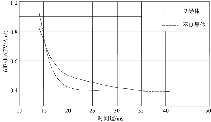
地质体中感应电流及与之对应的二次场随时间的变化率,主要受到地质体的岩性和物性参数(如电导率、磁导率、地质体尺寸大小、形状等)影响。衰减曲线变化速率的大小,主要与地质体的电性特征和几何形状有关。如图 2所示,对于良导体,二次场衰减速度慢;对于不良导体,二次场衰减速度较快①。
![]() 图 2 良导体和不良导体的dB/dt衰减曲线[18]Figure 2. dB/dt attenuation curve of good conductor and poor conductor
图 2 良导体和不良导体的dB/dt衰减曲线[18]Figure 2. dB/dt attenuation curve of good conductor and poor conductor实测地下含水层衰减曲线特征符合良导体衰减规律,结合含水层和围岩电阻率差别,对巴林左旗富河镇地区航空瞬变异常进行分类,筛选含水层产生的电磁异常。
2.3 视电阻率-深度计算
视电阻率-深度计算(Resistivity Depth Imaging,RDI)是一种近似反演方法,利用在时间域无论介质的形状和电性如何,其电磁响应都可以用衰减指数总和来表示这一特性,计算出随深度变化的视电阻率,在解释工作中被广泛采用。
瞬变电磁视电阻率数据是在近似探测深度处转化的有效地下电阻率,在观测位置下方产生连续分布的电阻率图像。得到的TEM视电阻率“等效”曲线,类似于MT数据分析中常用的Niblett-Bostick反演的电阻率-深度变换的实现[18-20]。
研究区各测线数据经过电阻率-深度计算后,绘制电阻率-深度剖面图,反映地下低阻异常体的分布信息。电阻率-深度单剖面图能够反映测量位置电阻率分布特征,可以作为整个测区的推断解释参考。
本文采用CHTEM-Ⅱ航空电磁测量系统配套的数据处理软件CHTEM Software、Geosoft公司的Oasis montaj地球物理数据处理软件及中国自然资源航空物探遥感中心自行研发的GeoProbe航空物探数据处理解释系统对采集数据进行预处理,根据电磁场的衰减信息获得TEM视电阻率“等效”曲线,进行视电阻率-深度计算。
2.4 航空电磁剖面反演
随着瞬变电磁方法理论研究的逐步深入和计算机硬件、软件技术的不断发展,已经有多个商业软件能够对时间域航空瞬变电磁测量数据进行建模、正演和反演,如澳大利亚EMIT公司的Maxwell、澳大利亚工业研究院的EM vision、加拿大Pet Ros Eikon公司开发的Emigma等,这些软件基本代表了国内外瞬变电磁的发展方向和数据处理水平。其中,Maxwell、EM Vision的反演结果相近且与实际地层的电性特征也较接近,而Emigma反演结果与实际出入较大[21-22]。
本次应用Maxwell反演通过求含水地层产生特定的电磁异常的组合来拟合实测dB/dt曲线,以此模拟含水层的分布形态,推断空间展布形态。
3. 航空瞬变电磁解释应用效果
3.1 dB/dT响应特征及衰减曲线特征
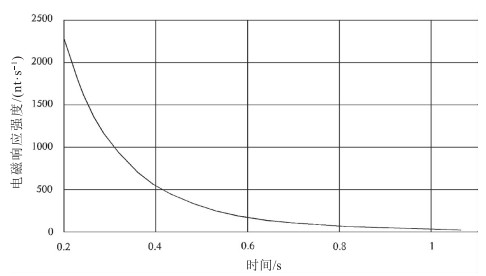
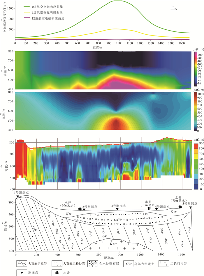
飞行测量获取了大量航空TEM异常,为筛选含水层异常,分析了航空TEM异常电磁响应、衰减曲线特征,并结合实测航磁异常和区域重力场特征进行综合研究[23]。研究区的含水地层主要是第四系全新统洪积砂砾石,物性相比隔水层具有较低的电阻率值和较低的磁化率值,且含水地层的衰减曲线特征表现为衰减速率较慢的特征,在0.2 ms异常强度约为2200 nT/s,衰减速度较均匀,在0.9 ms基本衰减至消失,符合良导体衰减规律。含水层的航空电磁响应通常为宽度较大的梯度较缓异常,且无磁异常(图 4)。
3.2 视电阻率-深度剖面解释
瞬变电磁场的扩散深度表示为:
δTD=√2ρtμ0, (1) 对于任意时间t,地下最大瞬变电场位于δTD深度,(1)式中ρ表示全区视电阻率,μ0=4π×10-7h/m,为大地磁导率。考虑到直升机航空电磁野外作业时飞行高度会影响成像时的精度,利用镜像原理,对快速成像的深度表达式可改进为:
δTD=|√2ρtμ0−h|, (2) 式中,h为吊舱离地高度,通过扩散深度δTD与时间t的关系可以得到电阻率-深度剖面,实现电阻率快速成像[11]。对研究区内的全部测线进行转换计算,并编制逐条测线的电阻率-深度剖面图,反映了测量位置纵向由浅到深的电阻率变化趋势,低阻层位于测区南部及东北部,且由西向东逐渐加厚得,主要位于浅地表位置(图 5)。根据电磁响应特征、反演结果,以双频激电实测的视电阻率值进行约束,逐条剖面推断地质体赋存形态和含水体分布,最终以收集的水井、钻井实际资料验证推断结果。
以图 6剖面位置为例,电阻率-深度剖面、反演结果及双频激电法测量的视电阻率均显示,在该测线中部200 m以浅有宽约1 km的低阻层,视电阻率值小于100 Ω·m,根据物性测量得到的电阻率结果,推断为含水的第四系洪积物砂砾石层;在地表以下200~300 m的位置,均表现为厚度约100 m的连续中高阻层,视电阻率值为100~500 Ω·m,推断是在含水层底部,由板岩粉砂岩组成的隔水层;在300~400 m深的位置,呈顶部拱起,中央厚边缘薄的高阻层,视电阻率值大于500 Ω·m,推断是产状为岩盖的二长花岗岩侵入地层中(图 6-b、c、d)。以岩石物性及异常响应特征为基础,视电阻率-深度剖面及反演结果为划分岩性及范围的主要依据,双频激电法作为约束,综合推断地层、侵入岩形态,顶部为渗水性较好的第四系残坡积亚砂土松散沉积层,中部为第四系洪积物砂砾石含水层,底部为大石寨组粉砂质板岩、泥岩并有燕山期早期的二长花岗岩呈岩盖产状侵入(图 6-e)。根据巴林左旗富河镇的取水井资料,见水位置顶面10~80 m,底面70~110 m,图 5-e中3口水井的含水层顶底面均与推断结果一致。
3.3 电阻率平面分布图及含水体分布
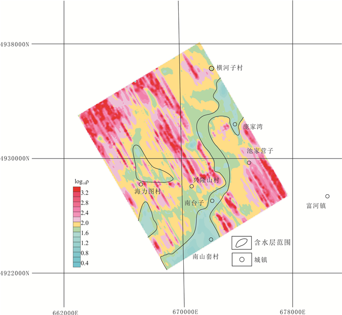
根据研究区航空电磁异常视电阻率-深度的综合解释结果及视电阻率与地层的对应关系,为推断含水地层的水平展布范围,根据视电阻率平面切片图,将视电阻率小于100 Ω·m范围的相对低阻区域圈定为含水地层。对不同深度的水平视电阻率切片图进行圈定,即可分析各个深度水层水平方向的变化。
巴林左旗富河镇地区地表以下20 m含水层分布如图 7,主要含水层由南山套至横河子村南,呈近NE走向,受到区域NNE向构造影响,研究区山脉走向以NE—NNE向为主,含水层位于2条NNE向隆起带间的洼地中,南山套村地势低洼,雨水易汇聚于此,含水层最宽处可达3 km,兴隆山村附近地势较高,地下水含量较少,含水层宽度仅500 m左右。从电阻率和村里打井情况看,地下含水层连续不断,至横河子村庞家湾一带,地势低缓,表面的松散沉积层渗水性较好,中间砂砾石层在接受降水后存储地下水,在横河子村—庞家湾一带形成宽度逾2 km的汇水盆地, 全区整体含水层形态与河流相似,推测原为古河道河床部位接受粒度较大的砂砾沉积形成,而海力图村南、北2个封闭的含水层可能原为小型湖泊或洼地。
3.4 三维地质模型
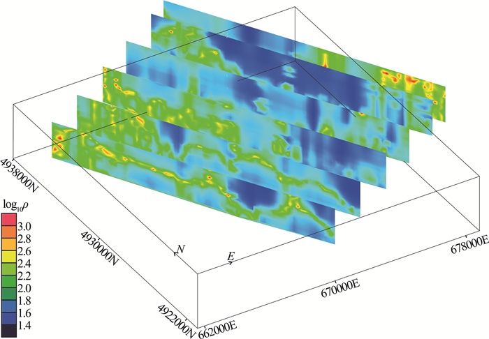
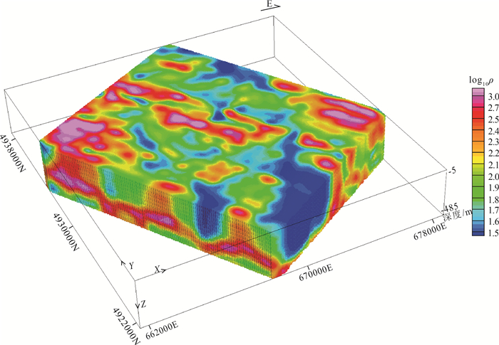
依据研究区岩石物性特征差异,以及富河镇地区水文地质和钻孔岩心资料,建立了电阻率与岩性对应关系,并对全区测线进行电阻率-深度计算,得到反映区内电性分布视电阻率三维模型体(图 7)。依据空间电阻率分布趋势,综合建立富河镇地区三维地质模型。
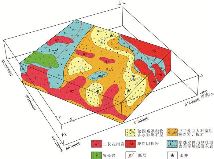
根据电阻率与岩性的相对关系,将视电阻率小于100 Ω·m范围的相对低阻区域圈定为含水砂砾石层,100~500 Ω·m的中高阻层圈定为泥岩、粉砂岩、板岩或凝灰岩组成的隔水层,大于500 Ω·m的高阻层圈定为二长花岗岩、花岗闪长岩、辉长岩等侵入岩体(图 8)。对于电阻率差异较小的岩性,则结合地质踏勘结果和钻井结果进行验证。
根据三维电阻率及水文地质资料,推断巴林左旗富河镇地区含水砂砾石层分布范围(图 9)。从空间形态分析,含水层浅部较宽,最宽可达3 km,到120 m深处,含水层变窄,宽度小于300 m。根据三维模型计算,研究区含水地层体积约5.47×10⁷m3,巴林左旗富河镇地区土壤平均体积含水量为8.3%,地下水储量共计约4.54×10⁶ t(图 8)。巴林左旗总面积6644 km2,2013年全旗地下水资源量为1.7589×10⁸ t,研究区面积140 km2,按巴林左旗地下水平均含量计算,含地下水3.71×10⁶ t,富河镇地区实际的地下水储量略高于巴林左旗平均值,城市乡村的发展建设和农牧业发展得到基本的水资源保证,然而该区仍然属于缺水地区,应合理开采和利用地下水,避免开设工厂等大量用水企业,取水井建议采水至120 m以浅,兼顾经济效益同时又保证了可持续发展。
研究区受大兴安岭区域构造影响,火山活动频发。顺构造带走向在研究区南北两侧发育2条火山岩喷发带,主要岩性为晚侏罗世玛尼吐组玻屑凝灰岩、角砾岩和熔岩,在地势上形成多个连续的丘陵。研究区中部地势低缓,沉积了大量全新统砂砾石,下伏地层为中二叠世大石寨组粉砂岩、泥岩及板岩,形成较好的储水和隔水环境。研究区还发生多期岩浆岩侵入活动,主要以岩盖、岩株形式产出(图 9)。
通过三维地质模型,可以清晰地反映各地层的厚度、空间分布信息及接触关系,并通过含水层体积估算出地下水储量,为城市农村的发展建设提供保证,为水文地质工作提供技术支撑,同时也为三维地质填图提供参考。
4. 结论
(1) 在水源匮乏的内蒙古巴林左旗地区开展直升机TEM测量,可以很好地反映含水地层与围岩的电性差异,异常数据经处理后与含水地层存在较明显的对应关系。该方法为勘探地下水工作提供了重要依据,航空瞬变电磁在同类地区的水文地质勘查方面具有很大的应用前景。
(2) 采用电阻率-深度法对航空瞬变电磁数据进行处理,得到的平面及三维视电阻率图清晰地反映出地层间的电性差异。结合反演结果、电磁响应dB/dT特征分析,圈定含水地层的范围,估算地下水储量,并建立三维地质模型,分析区域地质构造格架,为水文地质及三维地质填图工作提供支撑。
(3) 巴林左旗富河镇地区的含水层顶面主要埋深为10~30 m,最深可达200 m,含水层厚度30~80 m,最宽处可达3 km。地下水储量约4.54×10⁶ t,略高于巴林左旗平均水平,却仍属于缺水地区。水资源储量可满足基本的城市建设规划、农牧业发展,然而仍需要合理的开采利用,保证可持续发展。
致谢: 感谢中国自然资源航空物探遥感中心秦岭大别造山带航空物探遥感调查项目提供数据,感谢国家重点研发计划综合航空地球物理探测系统集成与方法技术示范课题组提供方法技术支持,感谢巴林左旗地方政府、富河镇政府提供水文地质资料,感谢审稿专家提出的宝贵修改意见和建议。 -
图 2 良导体和不良导体的dB/dt衰减曲线[18]
Figure 2. dB/dt attenuation curve of good conductor and poor conductor
表 1 巴林左旗地区岩(矿)石电阻率
Table 1 Resistivity for different lithology in Balinzuoqi area
岩石名称 电阻率最大值/(Ω·m) 电阻率最小值/(Ω·m) 电阻率均值/(Ω·m) 第四系坡积物 103 44 75 第四系洪积物 93 25 53 凝灰岩 1237 1799 1518 安山岩 1953 3431 2805 板岩 970 1711 1436 粉砂岩 443 1258 998 泥岩 216 963 503 变质粉砂岩 1589 4207 3374 辉绿岩 5558 7610 6825 花岗岩 2857 3962 3442 磁铁矿 1462 4845 2215 银多金属矿石 107 481 331 -
程守恩. 赤峰市巴林左旗水资源现状及节水潜力分析[J]. 内蒙古水利, 2014, (1) : 83-85. https://www.cnki.com.cn/Article/CJFDTOTAL-NMSL201401046.htm 高玉霞, 卜凤英. 巴林左旗水资源现状和可持续发展的探究[J]. 内蒙古水利, 2013, (6) : 92-93. https://www.cnki.com.cn/Article/CJFDTOTAL-NMSL201306052.htm Hoekstra P, Blohm M W. Case histories of time-domain electromagnetic soundings in environmental geophysics[C]//S H Ward. Geotechnical and Environmental Geophysics. Society of Exploration Geophysics, 1990, 2: 1-16.
Everett M E. Near-surface Applied Geophysics[M]. UK: Cambridge University Press, 2013.
牛之琏. 时间域电磁法原理[M]. 长沙: 中南大学出版社, 2007. Sattel D. An overview of Helicopter Time-Domain EM systems[J]. Aseg Extended Abstracts, 2009, 2009(1) : 1-6.
武欣, 薛国强, 方广有. 中国直升机航空瞬变电磁探测技术进展[J]. 地球物理学进展, 2019, 34(4) : 1679-1686. https://www.cnki.com.cn/Article/CJFDTOTAL-DQWJ201904050.htm Macnae J. Developments in broadband airborne electromagnetics in the past decade[C]//Proceedings of Exploration, Advances in Airborne Geophysics, 2007: 387-398.
Masrom S N, Samsudin A R. Application of airborne transient electromagnetic(Sky TEM) technique for buried valley detection in part of Hadsten, Aarhus County, Denmark[J]. Bulletin of the Geological Society of Malaysia, 2012, 58: 59-65. doi: 10.7186/bgsm58201210
Hesham E K, Osman A. Application of time-domain electromagnetic method in mapping saltwater intrusion of a coastal alluvial aquifer, North Oman[J]. Journal of Applied Geophysics, 2015, 115: 59-64. doi: 10.1016/j.jappgeo.2015.02.003
何怡原, 梁盛军, 连晟. 基于航空瞬变电磁法的宝清地区含水体分布特征研究[J]. 地球物理学进展, 2018, 33(5) : 2126-2133. https://www.cnki.com.cn/Article/CJFDTOTAL-DQWJ201805047.htm 张超. 大兴安岭南段巴林左旗—扎鲁特旗地区晚中生代岩浆作用及其构造背景[D]. 吉林大学博士学位论文, 2020. 付占荣, 陈会军. 内蒙古巴林左旗东山湾钨锡铍矿床地质特征及找矿前景[J]. 桂林工学院学报, 2004, (2) : 148-151. doi: 10.3969/j.issn.1674-9057.2004.02.004 翟鹏, 徐备, 王志伟, 等. 内蒙古苏尼特左旗卓仑音诺尔地区中二叠统哲斯组沉积环境、形成时代及意义[J]. 地质通报, 2019, 38(10) : 1647-1659. http://dzhtb.cgs.cn/gbc/ch/reader/view_abstract.aspx?file_no=20191007&flag=1 杨星辰, 叶培盛, 蔡茂堂, 等. 150ka以来内蒙古河套古大湖沉积物粒度记录的湖泊水位变化[J]. 地质通报, 2017, 36(6) : 1043-1050. doi: 10.3969/j.issn.1671-2552.2017.06.016 董进, 王永, 张世红, 等. 内蒙古黄旗海全新世湖泊沉积物粒度分析及其沉积学意义[J]. 地质通报, 2014, 33(10) : 1514-1522. doi: 10.3969/j.issn.1671-2552.2014.10.007 骆燕, 江民忠, 宁媛丽, 等. 不同类型低阻异常航电时间常数的特征分析[J]. 物探与化探, 2016, 40(5) : 991-997. https://www.cnki.com.cn/Article/CJFDTOTAL-WTYH201605024.htm 王笠洁, 龚育龄, 杨海燕, 等. 深度视电阻率成像在航空瞬变电磁法探测矿体的研究及应用[J]. 地球物理学进展, 2018, 33(4) : 1707-1712. https://www.cnki.com.cn/Article/CJFDTOTAL-DQWJ201804052.htm Spies B R, Raiche A P. Calculation of apparent conductivity for the transient electromagnetic(coincident loop) method using an HP-67 calculator. Geophysics, 1980, 45(7) : 1197-1204. doi: 10.1190/1.1441117
Ward S H, Hohmann G W. Electromagnetic theory for geophysical applications[C]//Misac NNabighianed. Electromagnetic Methods in Applied Geophysics—Theory. SEG, 1987: 221.
王兴春, 武军杰, 邓晓红, 等. 三套国外TEM软件正反演结果对比[J]. 物探与化探, 2012, 36(3) : 507-510. https://www.cnki.com.cn/Article/CJFDTOTAL-WTYH201203038.htm 朱琳, 赵丛, 江民忠, 等. Maxwell板状体反演在航空瞬变电磁法找矿实践中应用及效果[J]. 矿产勘查, 2018, 9(3) : 420-427. doi: 10.3969/j.issn.1674-7801.2018.03.019 张燕, 董云鹏, 程顺有, 等. 内蒙古赤峰地区重磁特征及其地质意义[J]. 地质通报, 2009, 28(5) : 594-602. doi: 10.3969/j.issn.1671-2552.2009.05.009 Alexander P. EM time constant(tau) analysis. Aurora: Geotech Lta, 2010.
-
期刊类型引用(8)
1. 孙旭鹏,李超楠. 瞬变电磁法在煤矿老窑采空区积水探测中的应用. 煤炭技术. 2024(03): 208-212 .  百度学术
百度学术
2. 胡斌. 瞬变电磁法在煤矿超前地质勘查中的应用. 能源与环保. 2024(06): 70-75 .  百度学术
百度学术
3. WEI Laonao,LIU Yunhe,ZHANG Bo. UAV-based transient electromagnetic 3D forward modeling and inversion and analysis of exploration capability. Global Geology. 2024(03): 154-166 .  必应学术
必应学术
4. 都兵,张旭晴,孙涛,陈峰,王琳炜. 基于时序InSAR的吉林省松原市宁江区地下水活动研究. 世界地质. 2024(03): 424-433 .  百度学术
百度学术
5. 翟皓,李桐林,康鑫泽,吴宇豪. 半航空瞬变电磁数据处理与解释在贺斯格乌拉露天煤矿水灾害勘探中的应用. 世界地质. 2024(03): 434-443 .  百度学术
百度学术
6. 秦莉旻. 物探技术在地下水资源污染防治中的应用研究. 环境科学与管理. 2023(03): 72-76 .  百度学术
百度学术
7. 范莹琳,潘树仁,杜松,李萌,赵岳,张玉峰,丁晏,宋思彤,车巧慧,王锋利. 基于半航空瞬变电磁法识别复杂地形废弃煤矿富水空间的应用研究. 煤炭科学技术. 2023(12): 79-89 .  百度学术
百度学术
8. 林康利. 基于航空物探的铁路地质选线研究. 工程地球物理学报. 2022(05): 603-609 .  百度学术
百度学术
其他类型引用(1)


 下载:
下载:
