Application of active and passive-sourced seismic surface wave exploration to the detecting of shallow overburden karst area
-
摘要:
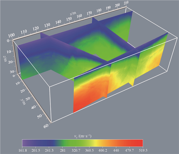
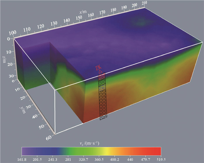
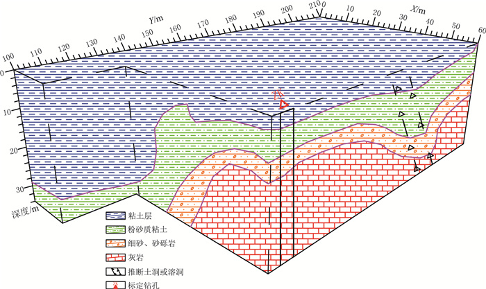
采用主-被动源地震面波勘探方法,对桂林市兴安县典型浅覆盖层实验区三维地质结构进行探测研究。结合主-被动源面波数据提取的频散曲线,拓宽了频带,提升了低频信号的分辨率。实验结果显示,测区内地下介质横波速度值范围为161.5~519.5 m/s, 根据速度值的差异将实验区地下介质大致分为4个层位,第一层速度范围为161.5~281 m/s, 第二层速度范围为281~360.5 m/s, 第三层速度范围为360.5~400.2 m/s, 第四层速度范围为400.2~519.5 m/s。结合钻孔资料,对应的第一层岩性为粘土层,第二层为粉砂质粘土,第三层为细砂-砂砾岩,第四层为灰岩,且局部土洞、溶洞等构造发育。研究结果表明,瑞雷面波勘探方法能够较准确地刻划浅覆盖层地下介质土层厚度、结构分布及土层与基岩面接触带起伏形态。
Abstract:The active and passive-sourced seismic surface wave exploration was carried out to study the three-dimensional geological structure of the typical shallow overburden area in Xing'an County, Guilin City.The dispersion curve extracted from active and passive surface wave data broadened the frequency band and improved the resolution of low-frequency signals.The experimental results show that the shear wave velocity of underground medium ranges from 161.5 m/s to 519.5 m/s in the survey area.According to the difference of velocity value, the underground medium in the experimental area is roughly divided into four layers.The velocity of the first layer ranges from 161.5 m/s to 281 m/s, the second from 281 m/s to 360.5 m/s, the third from 360.5 m/s to 400.2 m/s, and the fourth from 400.2 m/s to 519.5 m/s.Combined with the drilling data, the lithology of the above-mentioned four layers corresponds to clay, silty clay, sand to glutenite, and limestone, respectively; and some local structures such as soil caves and karst caves are locally developed.The research results show that the Rayleigh surface wave exploration method can more precisely describe the soil thickness, structure distribution and the undulating shape of the contact between the soil layer and the bedrock.
-
-
表 1 研究区地层岩性
Table 1 Stratigraphic lithology of the study area
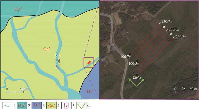
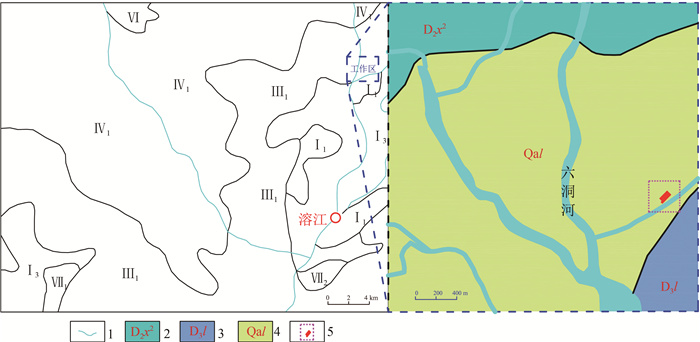
地层 地层代号 岩性 第四系冲积层 Qal 粘土夹粉砂、细砂 上泥盆统榴江组 D3l 微晶灰岩夹粒状灰岩 中泥盆统信都组第二段 D2x2 石英砂岩、泥质粉砂岩 表 2 实验区横波速度和岩性对比
Table 2 Comparison between shear wave velocity and lithology
层位 横波速度值/(m·s-1) 层位岩性 第一层 161~281 粘土层 第二层 281~360.5 粉砂质粘土 第三层 360.5~400.2 细砂-砂砾层 第四层 >400.2 灰岩 -
Aki K. Space and time spectra of stationary stochastic waves with special reference to microtremors[J]. Bull. Earthquake. Res. Inst. Tokyo, 1957, 35: 415-456.
王振东. 微动的空间自相关法及其实用技术[J]. 物探与化探, 1986, 10(2): 123-133. https://www.cnki.com.cn/Article/CJFDTOTAL-WTYH198602006.htm 何正勤, 丁志峰, 贾辉, 等. 用微动中的面波信息探测地壳浅部的速度结构[J]. 地球物理学报, 2007, 50(2): 492-498. doi: 10.3321/j.issn:0001-5733.2007.02.021 孙勇军, 徐佩芳, 凌盨群, 等. 微动勘查方法及其研究进展[J]. 地球物理学进展, 2009, 24(1): 326-334. https://www.cnki.com.cn/Article/CJFDTOTAL-DQWJ200901042.htm 罗松, 罗银河. SPAC系数计算方法研究[C]//中国地球科学联合会学术年会——专题14: 地下介质结构及其变化的地震面波背景噪声及尾波研究论文集. 北京: 中国地球物理学会, 2014: 755. 冯少孔. 微动勘探技术及其在土木工程中的应用[J]. 岩石力学与工程学报, 2003, 22(6): 1029-1036. doi: 10.3321/j.issn:1000-6915.2003.06.025 徐佩芬, 李传金, 凌盨群, 等. 利用微动勘察方法探测煤矿陷落柱[J]. 地球物理学报, 2009, 52(7): 1923-1930. doi: 10.3969/j.issn.0001-5733.2009.07.028 丁立锋, 徐佩芳, 凌苏群, 等. 微动勘探方法探测林南仓煤矿岩浆岩侵入体[J]. 煤炭科学技术, 2010, 38(7): 100-103. https://www.cnki.com.cn/Article/CJFDTOTAL-MTKJ201007031.htm 徐佩芳, 侍文, 凌苏群, 等. 二维微动剖面探测"孤石": 以深圳地铁7号线为例[J]. 地球物理学报, 2012, 55(6): 2120-2128. https://www.cnki.com.cn/Article/CJFDTOTAL-DQWX201206033.htm 徐佩芳, 李世豪, 杜建国, 等. 微动探测: 地层分层和隐伏断裂构造探测的新方法[J]. 岩石学报, 2013, 29(5): 1841-1845. https://www.cnki.com.cn/Article/CJFDTOTAL-YSXB201305028.htm 徐佩芬, 李世豪, 凌甦群, 等. 利用SPAC法估算地壳S波速度结构[J]. 地球物理学报, 2013, 56(11): 3846-3854. doi: 10.6038/cjg20131126 廖武林, 林亚洲, 李井冈, 等. 微动探测方法在武汉后湖勘察中的应用[J]. 地震工程与工程振动, 2014, 34(S1): 173-177. https://www.cnki.com.cn/Article/CJFDTOTAL-DGGC2014S1027.htm 张伟, 甘伏平, 梁东辉, 等. 利用微动法快速探测岩溶塌陷区覆盖层厚度[J]. 人民长江, 2016, 47(24): 51-54. https://www.cnki.com.cn/Article/CJFDTOTAL-RIVE201624011.htm 陈逢. 被动源面波勘探方法及其在城市地区的应用[D]. 中国地质大学(武汉)博士学位论文, 2018. 姜文龙, 涂善波, 何效周, 等. 基于车辆振动噪声的城市面波观测方法研究及其应用[J]. 地球物理学进展, 2020, 35(4): 1557-1564. https://www.cnki.com.cn/Article/CJFDTOTAL-DQWJ202004042.htm 李远林. 被动源面波法在渭河盆地地层结构分层中的应用研究[D]. 长安大学硕士学位论文, 2020. 刘国峰, 刘语, 孟小红, 等. 被动源面波和体波成像在内蒙古浅覆盖层区勘探应用[J]. 地球物理学报, 2021, 64(3): 937-948. https://www.cnki.com.cn/Article/CJFDTOTAL-DQWX202103016.htm Jones R. Surface wave technique for measuring the elastic properties and thickness of roads: theoretical development[J]. British J. Appl. Phys., 1962, 13(1): 21-29. doi: 10.1088/0508-3443/13/1/306
杨成林. 瑞雷波法勘探原理及其应用[J]. 物探与化探, 1989, 13(6): 465-468. https://www.cnki.com.cn/Article/CJFDTOTAL-WTYH198906008.htm 刘云祯, 王振东. 瞬态面波法的数据采集处理系统及其应用研究[J]. 物探与化探, 1996, 20(1): 28-34. https://www.cnki.com.cn/Article/CJFDTOTAL-WTYH601.003.htm 张碧星, 鲁来玉, 鲍光淑. 瑞利波勘探中"之"字形频散曲线研究[J]. 地球物理学报, 2002, 45(2): 263-274. doi: 10.3321/j.issn:0001-5733.2002.02.013 刘强. 基于瑞雷波理论的公路无损检测方法研究[D]. 长安大学博士学位论文, 2009. 潘冬明. 瑞雷面波频散分析与应用[D]. 中国矿业大学博士学位论文, 2009. 刘雪峰, 凡友华. Rayleigh波勘探中"之"字形频散曲线"起跳点"频率研究[J]. 地球物理学报, 2011, 54(8): 2124-2135. doi: 10.3969/j.issn.0001-5733.2011.08.020 杨威. 瑞雷波在岩溶勘查中的应用研究[D]. 中南大学硕士学位论文, 2012. 郑柱坚. 多道瞬态面波法在强夯地基处理工程的应用[J]. 云南大学学报(自然科学版), 2012, 34(S2): 291-295. https://www.cnki.com.cn/Article/CJFDTOTAL-YNDZ2012S2049.htm 袁伟, 周洪生, 刘成东, 等. 短时傅立叶变换和广义S变换用于提取面波频散曲线效果对比研究[J]. 物探化探计算技术, 2013, 35(1): 54-59. doi: 10.3969/j.issn.1001-1749.2013.01.09 Park C B, Miller R D, Ryden N, et al. Combined use of active and passive surface waves[J]. Journal of Environmental & Enginerring Geophysics, 2006, 10(3): 323-334.
张维, 何正勤, 胡刚, 等. 用人工源和天然源面波联合探测浅层速度结构[J]. 震灾防御技术, 2012, 7(1): 26-36. doi: 10.3969/j.issn.1673-5722.2012.01.003 张维, 何正勤, 胡刚, 等. 用面波联合勘探技术探测浅部速度结构[J]. 地球物理学进展, 2013, 28(4): 2199-2206. https://www.cnki.com.cn/Article/CJFDTOTAL-DQWJ201304069.htm


 下载:
下载:
