
Lithologic classification method based on multi-source remote sensing and aero geophysical data
-
摘要:
遥感影像可以获取地表岩性的光谱、色调、纹理等信息,但其所提取的信息局限于地表,对深层地质问题解释并无明显优势;航空物探数据则对地下深部异常体信息的提取更具优势。单一某类数据难以满足基础地质、资源勘查等方面复杂应用的需求。因此,提出一种遥感与航空物探信息联合分析方法,以新疆某地为研究区,结合遥感与航空物探多源数据特征,基于随机森林方法对研究区岩性进行分类。结果表明,与使用单一某类数据相比,遥感与航空物探信息联合分析方法能提高岩性分类精度。该方法对于推动遥感与航空物探技术在地质填图中的精细化应用,具有一定实用价值与指导意义。
Abstract:Remote sensing images can acquire the spectrum, tone, texture and other information of the surface rocks, but the extracted information is limited to the surface and has no obvious advantage in the interpretation of deep geological information.Aero geophysical data has more advantages in extracting information of underground abnormal bodies. A single type of data cannot meet the needs of complex applications in basic geology and resource exploration.Therefore, a combined method of remote sensing and aero geophysical analysis was proposed. A certain area in Xinjiang was taken as the study area to classify the lithology through the analysis of multi-source remote sensing images and aero geophysical data based on the random forest method.The results show that the proposed method can improve the accuracy of lithologic classification in the study area compared with a single type of data.The proposed method has certain practical value and guiding significance in promoting the fine application of remote sensing and aero geophysical exploration technology in geological mapping.
-
遥感与航空物探具有探测范围广、数据获取速度快、信息量大等特点,在地学领域尤其是大面积区域地质调查研究中发挥着重要作用。利用遥感与物探信息进行岩性识别是指通过分析影像光谱、地球物理场等信息特征,确定地表岩性类型与空间分布范围。利用遥感与航空物探信息进行岩性识别分类一直是地质解译工作的重要内容,也是地质填图的重要手段。根据使用的数据可将岩性识别划分的方法分为三大类。
第一类是基于影像光谱特征的岩性分类方法。Abrams等[1]、Rowan等[2]、Crosta等[3]基于遥感多光谱影像,采用波段比值等方法对研究区进行地质填图。Rutz等[4]研究了提高TM图像的热液蚀变矿物的光谱响应的方法。继ETM数据之后,ASTER数据也被广泛普遍应用,增加了热红外波段的岩矿硅酸盐信息,使岩石分类与识别更有效。Guha等[5]基于ASTER数据,利用波段比值,提出了几个新的指数,并结合主成分分析(PCA)进行地质填图。Feizollah等[6]将ASTER数据的可见光近红外-短波红外光谱特征、热红外波段特征、波段比值、纹理特征及主成分分析特征应用至随机森林分类器中,对研究区域进行岩性识别,提高了识别精度。近年,高空间分辨率遥感数据、高光谱遥感数据、Sentinel-2数据、雷达数据等也越来越多地被应用于地质填图中。Kassouk等[7]采用高空间分辨率数据SPOT5图像和DEM数据,基于面向对象分类方法,识别区域地质单元。Kruger等[8]利用HyMap高光谱影像将陶土原始蚀变花岗岩和高岭土作为端元组分参与分类识别,制作了陶土丰度图。Enton[9]基于HyMap和ASTER数据,对格林兰中东部地区岩性进行了划分。
第二类是基于航空物探信息的岩性填图方法。遥感影像通常只能获取地表地质体的相关信息,难以获取覆盖层之下的地质体信息,而物探数据在该方面具有较明显的优势。众多学者通过航空电磁数据分析,完成岩性填图[10-11];利用航磁、航放数据结合跟踪地层界线,明显改善了区域地质填图效果。Mohamed等[12]、Zhang等[13]、Maacha等[14]基于航磁数据和伽玛能谱数据,通过欧拉反褶积计算、比值计算(如K/Th、K/U、U/Th等)等技术方法进行区域地质填图。Akinlalu等[15]基于航磁数据,利用总水平导数、欧拉反褶积、快速傅里叶变换、源边缘检测等技术方法对研究区主要地质结构进行解释。Mohammad等[16]通过区域场分离、化极(RTP)、功率谱曲线、二维磁性地质体反演等技术方法对航磁数据进行处理和分析,对中东沙漠瓦迪泽顿地区的岩性特征和构造进行解释。
第三类是遥感与航空物探信息联合的岩性识别方法。遥感技术在岩性识别、构造解译、侵入体单元划分、新生界沉积物成因分类等方面具有较明显的优势,而航空物探技术在划分岩性(地层)、区分岩相、圈定侵入岩体、划分岩体的侵入期次和相带、研究隐伏地质体、火山机构等方面发挥了重要作用。如何将遥感和地球物理数据联合起来应用至地质填图中是当前研究的热点。Ranjbar等[17]利用ASTER、Landsat ETM和航磁数据,对伊朗中部火山沉积带(区内斑岩矿床和热液蚀变带发育良好)进行了填图和岩性识别。Hewson等[18]通过整合ASTER数据及其衍生的数据产品、地球物理数据、数字高程模型及植被覆盖信息,有效地协助了半干旱地区的地质填图。王东明等[19]基于土壤、航磁、遥感数据,利用多源数据解译的方法,完成森林-沼泽浅覆盖区地质填图工作。联合遥感与物探数据,能够丰富特殊地质地貌区填图成果,优化野外踏勘路线部署,增加覆盖层之下基岩信息的提取内容,但是目前的方法缺乏系统化的特征,有些应用仍是以目视解译为主,且缺少对特征重要性的分析。
本文以新疆某区域为例,联合多源遥感和航空物探数据,提取多种遥感和物探信息特征,利用随机森林进行岩性分类方法研究;通过精度评价,对比分析不同特征组合的分类精度,并分析不同特征在岩性分类中的重要性。本文研究的方法发挥了遥感与航空物探在地质填图中的优势,对于1:5万特殊地质地貌区地质填图[20-21]具有一定实用价值和指导意义。
1. 研究区概况
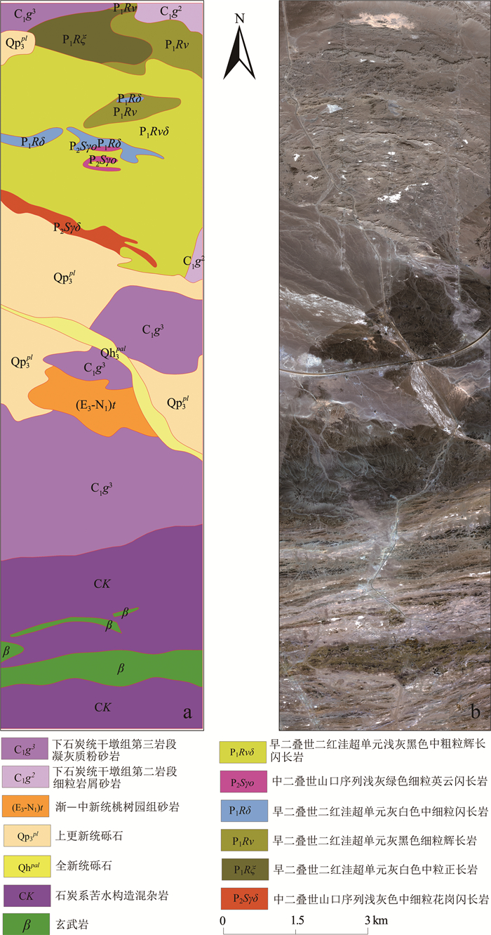
研究区位于新疆东大山地区,区内海拔较高,交通不便利,属于基岩裸露区,区内岩性丰富,岩石出露较好,基本无植被覆盖,元古宇、古生界、中生界、新生界均有出露,其中以古生界石炭系分布最广,该地区在基岩裸露区地质填图中具有一定的代表性。出露的石炭系主要有下石炭统雅满苏组、干墩组;中石炭统梧桐窝子组、苦水组、土古土布拉克组。新生界主要包括古近系—新近系和第四系。区内侵入岩极发育,以华力西期侵入岩分布最广泛。华力西早期侵入岩主要分布于研究区北部,岩性主要为二长闪长岩、闪长岩、粗粒花岗岩等;华力西中期侵入岩主要分布于研究区南北两侧,北部岩性较复杂,超基性、基性、中性、酸性岩均有出露,主要岩石类型为辉长岩、辉长辉绿玢岩、闪长玢岩、二长花岗岩、花岗岩、花岗斑岩等;华力西晚期侵入岩主要分布于研究区中部,岩性非常复杂,超基性—酸性岩均有分布,主要岩性为辉长岩、闪长岩、闪长玢岩、石英二长闪长岩、花岗岩等(图 1-a)。
![]() 图 1 1:5万研究区地质图(a)和GF-2影像(b)Figure 1. 1:50000 geological map (a) and GF-2 image(b)of the study area
图 1 1:5万研究区地质图(a)和GF-2影像(b)Figure 1. 1:50000 geological map (a) and GF-2 image(b)of the study area2. 研究方法
2.1 数据来源
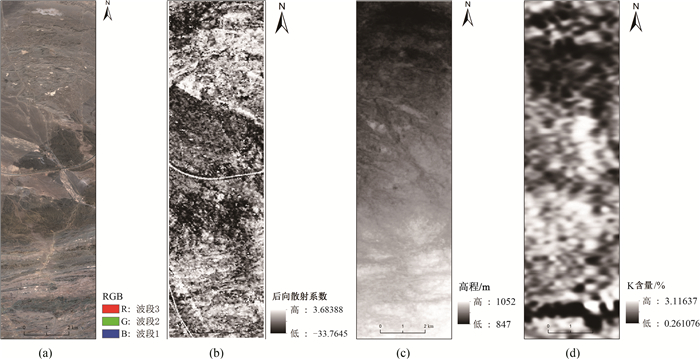
本文采用多源遥感数据,包括高分二号(GF-2)、ASTER、SAR影像哨兵1号(Sentinel-1)数据和DEM数据。GF-2全色波段分辨率达到0.8 m,能更清晰地反映地质体的结构、纹理和边界特征(图 1-b);ASTER影像包括可见光近红外(VNIR)、短波红外(SWIR)、热红外(TIR)共14个光谱通道,光谱信息非常丰富,可以较明显地显示地层、岩石等地质体信息(图 2-a)。本次选择的Sentinel-1数据为干涉宽幅模式(TOPS Mode)的斜距单视复数数据(IW SLC),空间分辨率为5 m×20 m,采用VV和VH双极化方式,不同岩性的后向散射特征具有差异性(图 2-b)。选用的DEM数据为ASTER GDEM V2版数据,其分辨率为30 m(图 2-c)。采用的物探数据源自研究区1:2.5万航空物探综合站(磁、电、放)实测资料[24],根据前人物探数据岩性分类相关研究[22-24]中使用的特征,本次研究选择航磁ΔT化极场,航空伽玛能谱K、U、Th含量及航放总计数率(TC),视电阻率值等特征。图 2-d显示了伽玛能谱K含量数据,空间分辨率为50 m。
![]() 图 2 研究区ASTER影像(a)、Sentinel-1 VV影像(b)、DEM(c)和伽玛能谱钾含量(d)Figure 2. ASTER image (a), Sentinel-1 VV image(b), DEM(c)and Gamma energy spectrum potassium content(d) of the study area
图 2 研究区ASTER影像(a)、Sentinel-1 VV影像(b)、DEM(c)和伽玛能谱钾含量(d)Figure 2. ASTER image (a), Sentinel-1 VV image(b), DEM(c)and Gamma energy spectrum potassium content(d) of the study area2.2 数据特征提取
将多源遥感数据和航空物探数据配准后叠加,分别提取多种遥感和物探信息特征(表 1),遥感信息特征主要包括光谱特征、波段比值特征、主成分分析特征(PC1-PC9)、纹理特征、地形特征、空间坐标信息特征和后向散射系数等特征。其中,纹理特征提取GF-2影像的灰度共生矩阵,地形特征提取DEM的地形耐用指数(Terrain Ruggedness Index, TRI)、地形位置指数(Topographic Position Index, TPI)和粗糙度(Roughness)3个地形指数[25]。物探信息特征主要包括化极磁场值M,伽玛能谱U、Th、K含量与总道计数率(TC)、比值特征、视电阻率等特征。
表 1 遥感与物探信息特征提取Table 1. Feature extraction from remote sensing and geophysical data特征类型 特征参数 数据源 遥感信息特征 光谱特征 VNIR1-3, SWIR1-6, TIR1-5 ASTER 波段比值 2/1, 4/3, 5/3, 5/4, 5/6, 5/3+1/2, 9/8, (4+6)/5, (5+7)/6, (7+9)/8 主成分分析 PC1-PC9 纹理特征 均值,方差,同质性,反差,差异性,熵,二阶矩,相关性 GF-2 地形特征 TPI, TRI, Roughness DEM 空间坐标信息 X, Y 后向散射系数 VV, VH Sentinel-1 物探信息特征 化极磁场 化极磁场值M 1:2.5万航空放射性测量 伽玛能谱 U, Th, K与总道计数率(TC) 1:2.5万频率域航电测量 比值特征 K/U, K/Th, U/Th 电阻率 视电阻率值 1:2.5万航空磁测 2.3 随机森林
随机森林(Random Forest, RF)是一种较新的机器学习模型,与梯度提升决策树类似,也是一个树型分类器的集合[26]。由于随机森林算法可以很好地预测多达几千个解释变量,可以产生高准确度的分类器,处理缺失数据及异常值,并且可以较好地避免过度拟合等[27-28],已越来越广泛地被应用于遥感图像分类领域中。随机森林在原理上指利用自助法重采样的方式,从训练样本N中有放回地重复随机抽取k个样本,然后生成新的训练样本集,再根据自助样本集生成的k个分类树组成随机森林,最后根据新数据的分类结果,按分类树投票多少形成的分数而定。随机森林中的每一棵决策树都为二叉树,根据自顶向下的递归分裂原则对训练集进行划分。本文基于遥感和物探数据,利用随机森林(RF)分类器,进行不同特征组合的岩性分类,表 2是基于遥感信息特征、航空物探信息特征,以及遥感和航空物探联合特征的岩性分类特征组合,并分析基于不同特征组合的分类效果与精度。此外,对各类特征在分类过程中的重要性进行评价。通过RF交叉验证函数计算错误率随特征数量的变化关系,然后依据重复运行10次错误率的均值,计算正确分类精度与特征数目的变化关系,观察最高分类精度对应的特征数量,并确定特征重要性。
表 2 岩性分类特征组合Table 2. Different feature combination for lithology classification组号 特征组合 特征个数/个 A 遥感信息特征 48 B 物探信息特征 10 C 遥感信息和航空物探信息联合特征 58 3. 结果与分析
研究区包括下石炭统干墩组第二岩段细粒岩屑砂岩(C1g2)、下石炭统干墩组第三岩段凝灰质粉砂岩(C1g3)、早二叠世二红洼超单元灰白色中粒正长岩(P1Rξ)、早二叠世二红洼超单元灰黑色细粒辉长岩(P1Rν)、早二叠世二红洼超单元灰白色中细粒闪长岩(P1Rδ)、早二叠世二红洼超单元浅灰黑色中粗粒辉长闪长岩(P1Rvδ)、中二叠世山口序列浅灰绿色细粒英云闪长岩(P2Sγo)、中二叠世山口序列浅灰色中细粒花岗闪长岩(P2Sγδ)、上更新统砾石(QP3pl)、全新统砾石(Qhpal)、古近系—新近系渐—中新统桃树园组砂岩((E3-N1)t)、石炭系苦水构造混杂岩(CK)和玄武岩(β)共13种岩性类别。本文的训练样本和验证样本均基于图 1-a中1:5万地质调查图进行采集,区内13个岩性类别共选取训练样本6927个,验证样本3618个(单位:像元),具体类别样本数目见表 3。
表 3 岩性分类样本选取Table 3. Sample selection for lithology classification类别 训练样本/个 验证样本/个 下石炭统干墩组第二岩段细粒岩屑砂岩(C1g2) 162 107 石炭系下石炭统干墩组第三岩段凝灰质粉砂岩(C1g3) 1275 512 早二叠世二红洼超单元灰白色中粒正长岩(P1Rξ) 213 135 早二叠世二红洼超单元灰黑色细粒辉长岩(P1Rν) 324 207 早二叠世二红洼超单元灰白色中细粒闪长岩(P1Rδ) 171 117 早二叠世二红洼超单元浅灰黑色中粗粒辉长闪长岩(P1Rvδ) 912 549 中二叠世山口序列浅灰绿色细粒英云闪长岩(P2Sγo) 46 34 中二叠世山口序列浅灰色中细粒花岗闪长岩(P2Sγδ) 152 145 上更新统砾石(QP3pl) 1130 567 全新统砾石(Qhpal) 161 232 渐—中新统桃树园组砂岩(E3-N1)t 244 214 石炭系苦水构造混杂岩(CK) 1540 498 玄武岩(β) 597 301 总数 6927 3618 利用训练样本特征组合训练随机森林模型,对整个研究区进行分类,分类精度通过总体分类精度和Kappa系数进行评价。总体精度(Overall Accuracy, OA)指每一类正确分类的样本数量之和与总样本数比值。Kappa系数是一种用于一致性检验的精度衡量指标。具体计算方法参考公式:
Kappa=OA−pe1−pe,pe=m∑i=1ai×bin×n (1) 其中, n为样本总数,m为类别总数,ai为第i类的真实样本个数(选自研究区地质图),bi为第i类预测出的样本个数。
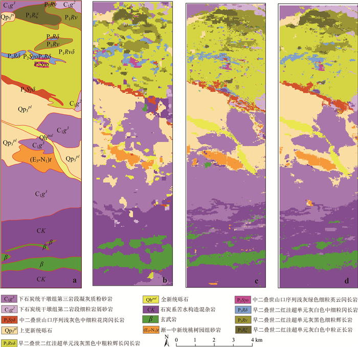
由图 3可知,遥感信息特征对于砂岩、第四系冲洪积物识别效果较好,而对于混杂岩和正长岩的识别效果较差;相比之下,物探信息特征对于第四系冲洪积物、冲积物识别效果较差,而对于混杂岩、玄武岩和正长岩的识别效果较好。将遥感与物探信息特征联合后,能弥补各自的不足。
![]() 图 3 1:5万研究区地质图(a)、基于遥感特征组合分类结果(b)、基于物探特征组合分类结果(c)和基于遥感和物探联合特征组合分类结果(d)Figure 3. 1:50000 geological map of the study area(a), classification result based on remote sensing features (b), based on geophysical exploration features (c) and based on joint remote sensing and geophysical exploration features (d)
图 3 1:5万研究区地质图(a)、基于遥感特征组合分类结果(b)、基于物探特征组合分类结果(c)和基于遥感和物探联合特征组合分类结果(d)Figure 3. 1:50000 geological map of the study area(a), classification result based on remote sensing features (b), based on geophysical exploration features (c) and based on joint remote sensing and geophysical exploration features (d)进一步定量比较不同特征组合分类效果,基于1:5万研究区地质图,通过误差混淆矩阵统计分类的总体精度和Kappa系数(表 4)可以看出,A、B、C三组不同特征的分类结果中,C组基于遥感和物探信息联合特征分类的总体精度(80.29%)和Kappa系数(77.74%)最高,A组单独使用遥感信息特征的分类总体精度(70.95%)和Kappa系数(67.06%)高于B组物探特征的总体精度(65.48%)和Kappa系数(60.81%)。结果说明,遥感和物探信息特征联合后,对于岩性的识别能力进一步提升。
表 4 不同特征组合岩性分类的精度对比Table 4. Accuracy comparison of lithology classification of different feature combinations组号 特征组合 RF 总体精度/% Kappa/% A 遥感信息特征 70.95 67.06 B 物探信息特征 65.48 60.81 C 遥感和航空物探信息联合特征 80.29 77.74 特征重要性分析有助于探明各种特征对于分类任务的贡献度,对于后期的分类研究具有一定的指导意义。在C组特征分类过程中,对所有特征进行重要性分析,由RF交叉验证函数,经过10折交叉验证并重复10次均值,发现当特征数为20时模型可以达到较高的精度,将所有特征进行重要性排序并列出前20个特征(图 4)。这20个特征中,物探特征占比45%,其中包括航磁化极场值、航放(U、Th、K)含量与总道计数率(TC)、航电换算视电阻率值等,说明航磁、航放和航电测量成果数据在该区岩性分类中能发挥重要作用。遥感数据占比55%,其中空间位置信息重要性较高,说明当区域岩性分布具有空间延续性且不同类别分层性明显时,融入空间位置信息有助于精度分类提高。此外,主成分分析PCA3,热红外特征(TIR1,TIR2,TIR4)和短波红外特征(SWIR3,SWIR1)及波段比5/4也发挥了重要作用,而纹理特征、地形特征和雷达后向散射特征重要性较低。
4. 结论
本文主要基于多源遥感和航空物探数据,从多光谱和SAR影像提取多种遥感信息特征,并结合空间特征和多参数航空物探信息特征,构成高维特征向量,基于随机森林利用不同特征组合实现岩性分类,并对重要特征进行分析。
(1) 基于多源遥感数据提取的多光谱特征,并与物探特征的联合,较大程度地提高了中等分辨率遥感影像在1:5万岩性分类中的精度。
(2) 运用随机森林方法可以通过特征重要性分析实现高维特征的降维,为今后利用地质、物探、化探、遥感信息进行岩性分类提供了新的解决方案。
(3) 本文方法适用于工作人员较难到达的区域,譬如特殊地质地貌区填图中的高山峡谷区和境外区域,通过前期小规模区域地质调查或者小比例尺地质资料获取样本信息,对分类器进行训练进而对周边大范围区域进行岩性分类。在野外地质填图过程中,根据调查资料,对分类器进行训练,提升分类精度,有效服务地质填图工作。
致谢: 感谢中国地质科学院地质力学研究所胡健民教授对本文研究工作的支持与建议,感谢中国自然资源航空物探遥感中心钟昶高级工程师对遥感高分数据融合处理的技术支持;感谢审稿专家对本文提出的宝贵意见及建议。 -
![]()
图 1 1:5万研究区地质图(a)和GF-2影像(b)
Figure 1. 1:50000 geological map (a) and GF-2 image(b)of the study area
![]()
图 2 研究区ASTER影像(a)、Sentinel-1 VV影像(b)、DEM(c)和伽玛能谱钾含量(d)
Figure 2. ASTER image (a), Sentinel-1 VV image(b), DEM(c)and Gamma energy spectrum potassium content(d) of the study area
![]()
图 3 1:5万研究区地质图(a)、基于遥感特征组合分类结果(b)、基于物探特征组合分类结果(c)和基于遥感和物探联合特征组合分类结果(d)
Figure 3. 1:50000 geological map of the study area(a), classification result based on remote sensing features (b), based on geophysical exploration features (c) and based on joint remote sensing and geophysical exploration features (d)
表 1 遥感与物探信息特征提取
Table 1 Feature extraction from remote sensing and geophysical data
特征类型 特征参数 数据源 遥感信息特征 光谱特征 VNIR1-3, SWIR1-6, TIR1-5 ASTER 波段比值 2/1, 4/3, 5/3, 5/4, 5/6, 5/3+1/2, 9/8, (4+6)/5, (5+7)/6, (7+9)/8 主成分分析 PC1-PC9 纹理特征 均值,方差,同质性,反差,差异性,熵,二阶矩,相关性 GF-2 地形特征 TPI, TRI, Roughness DEM 空间坐标信息 X, Y 后向散射系数 VV, VH Sentinel-1 物探信息特征 化极磁场 化极磁场值M 1:2.5万航空放射性测量 伽玛能谱 U, Th, K与总道计数率(TC) 1:2.5万频率域航电测量 比值特征 K/U, K/Th, U/Th 电阻率 视电阻率值 1:2.5万航空磁测  下载: 导出CSV
表 2 岩性分类特征组合
Table 2 Different feature combination for lithology classification
组号 特征组合 特征个数/个 A 遥感信息特征 48 B 物探信息特征 10 C 遥感信息和航空物探信息联合特征 58
下载: 导出CSV
表 3 岩性分类样本选取
Table 3 Sample selection for lithology classification
类别 训练样本/个 验证样本/个 下石炭统干墩组第二岩段细粒岩屑砂岩(C1g2) 162 107 石炭系下石炭统干墩组第三岩段凝灰质粉砂岩(C1g3) 1275 512 早二叠世二红洼超单元灰白色中粒正长岩(P1Rξ) 213 135 早二叠世二红洼超单元灰黑色细粒辉长岩(P1Rν) 324 207 早二叠世二红洼超单元灰白色中细粒闪长岩(P1Rδ) 171 117 早二叠世二红洼超单元浅灰黑色中粗粒辉长闪长岩(P1Rvδ) 912 549 中二叠世山口序列浅灰绿色细粒英云闪长岩(P2Sγo) 46 34 中二叠世山口序列浅灰色中细粒花岗闪长岩(P2Sγδ) 152 145 上更新统砾石(QP3pl) 1130 567 全新统砾石(Qhpal) 161 232 渐—中新统桃树园组砂岩(E3-N1)t 244 214 石炭系苦水构造混杂岩(CK) 1540 498 玄武岩(β) 597 301 总数 6927 3618
下载: 导出CSV
表 4 不同特征组合岩性分类的精度对比
Table 4 Accuracy comparison of lithology classification of different feature combinations
组号 特征组合 RF 总体精度/% Kappa/% A 遥感信息特征 70.95 67.06 B 物探信息特征 65.48 60.81 C 遥感和航空物探信息联合特征 80.29 77.74
下载: 导出CSV
-
Abrams M J, Ashley R P, Rowan L C, et al. Mapping of hydrothermal alteration in the Cuprite mining district, Nevada, using aircraft scanner images for the spectral region 0.46 to 2.36μm[J]. Geology, 1977, 5(12): 713-718. doi: 10.1130/0091-7613(1977)5<713:MOHAIT>2.0.CO;2
Rowan L C, Goetz A F H, Ashley R P. Discrimination of hydrothermally altered and unaltered rocks in visible and near infrared multispectral images[J]. Geophysics, 1977, 42(3): 522-535. doi: 10.1190/1.1440723
Crosta A, Moore J M M. Enhancement of Landsat Thematic Mapper imagery for residual soil mapping in SW Minais Gerais State, Brazil: a prospecting case history in Greenstone belt terrain[C]//Proceedings of the 7th ERIM Thematic Conference: Remote sensing for exploration geology, 1989: 1173-1187.
Ruiz-armenta J R, Prol-ledesma R M. Techniques for enhancing the spectral response of hydrothermal alteration minerals in Thematic Mapper images of Central Mexico[J]. Int. J. Remote Sens., 1998, 19(10): 1981-2000. doi: 10.1080/014311698215108
Guha A, Ghosh B, Vinod K, et al. Implementation of reflection spectroscopy based new ASTER indices and principal components to delineate chromitite and associated ultramafic-mafic complex in parts of Dharwar Craton, India[J]. Advances in Space Research, 2015, 56: 1453-1468. doi: 10.1016/j.asr.2015.06.043
Masoumi F, Eslamkish T, Abkar A A, et al. Integration of spectral, thermal, and textural features of ASTER data using Random Forests classification for lithological mapping[J]. J. Afr. Earth Sci., 2017, 129: 445-457. doi: 10.1016/j.jafrearsci.2017.01.028
Kassouk Z, Thouret J-C, Gupta A, et al. Object-oriented classification of a high-spatial resolution SPOT5 image for mapping geology and landforms of active volcanoes: Semeru case study, Indonesia[J]. Geomorphology, 2014, 221: 18-33. doi: 10.1016/j.geomorph.2014.04.022
Kruger J, Westermann R. Linear algebra operators for GPU implementation of numerical algorithms[J]. ACM Transaction on Graphics, 2003, 22(3): 908-916. doi: 10.1145/882262.882363
Enton B. Mineral mapping in the Kap Simpson complex, central East Greenland, using HyMap and ASTER remote sensing data[J]. Advances in Space Research, 2011, 47(1): 60-73. doi: 10.1016/j.asr.2010.08.021
方迎尧, 王卫平, 肖刚毅, 等. 频率域航空电磁法岩性地质单元填图技术[J]. 物探与化探, 2010, 34(3): 308-314. https://www.cnki.com.cn/Article/CJFDTOTAL-WTYH201003010.htm 丁志强, 程志平, 李飞, 等. 频率域航空电磁法视电阻率转换在岩性构造填图中的应用[J]. 桂林理工大学学报, 2013, 33(1): 45-49. doi: 10.3969/j.issn.1674-9057.2013.01.008 Youssef M, Elkhodary S T. Utilization of airborne gamma ray spectrometric data for geological mapping, radioactive mineral exploration and environmental monitoring of southeastern Aswan city, South Eastern Desert, Egypt[J]. Geophysical Journal International, 2013, 195: 1689-1700. doi: 10.1093/gji/ggt375
Zhang H, Jia P, Zhang X, et al. The application of airborne geophysics data for rapid regional geological mapping in Northwestern Angola[J]. Sains Malaysiana, 2017, 46(11): 2109-2118. doi: 10.17576/jsm-2017-4611-11
Maacha L, Jaffal M, Jarni A, et al. A contribution of airborne magnetic, gamma ray spectrometric data in understanding the structure of the Central Jebilet Hercynian massif and implications for mining[J]. J. Afr. Earth Sci., 2017, 134: 389-403. . doi: 10.1016/j.jafrearsci.2017.07.012
Akinlalu A A, Adelusi A O, Olayanju G M, et al. Aeromagnetic mapping of basement structures and mineralisation characterisation of Ilesa Schist Belt, Southwestern Nigeria[J]. J. Afr. Earth Sci., 2018, 138: 383-391. doi: 10.1016/j.jafrearsci.2017.11.033
Mohammad G A, Atef A M I, Ahmed A E, et al. Analysis and interpretation of aeromagnetic data for Wadi Zeidum area, Central Eastern Desert, Egypt[J]. Egyptian Journal of Petroleum, 2018, 27: 285-293. doi: 10.1016/j.ejpe.2017.04.002
Ranjbar H, Masoumi F, Carranza E J M. Evaluation of geophysics and space borne multispectral data for alteration mapping in the Sar Cheshmeh mining area, Iran[J]. Int. J. Remote Sens., 2011, 32(12): 3309-3327. doi: 10.1080/01431161003745665
Hewson R, Robson D, Mauger A, et al. Using the Geoscience Australia-CSIRO ASTER maps and airborne geophysics to explore Australian geoscience[J]. Journal of Spatial Science, 2015, 60(2): 207-231. doi: 10.1080/14498596.2015.979891
王东明, 田世攀, 张昱, 等. 森林-沼泽浅覆盖区地质填图方法试验——以黑龙江1: 5万望峰公社幅为例[J]. 地质通报, 2021, 40(5): 782-797. http://dzhtb.cgs.cn/gbc/ch/reader/view_abstract.aspx?file_no=20210513&flag=1 王涛, 计文化, 胡健民, 等. 专题地质填图及有关问题讨论[J]. 地质通报, 2016, 35(5): 633-641. doi: 10.3969/j.issn.1671-2552.2016.05.001 胡健民, 陈虹, 邱士东, 等. 覆盖区区域地质调查(1: 50000)思路、原则与方法[J]. 地球科学, 2020, 45(12): 4291-4312. https://www.cnki.com.cn/Article/CJFDTOTAL-DQKX202012002.htm 廖桂香, 李振辉. 航空物探方法(航电、航磁、航放)解决的地质问题实例四则[J]. 贵州地质, 2013, 30(3): 213-218 doi: 10.3969/j.issn.1000-5943.2013.03.008 祁程, 田宇, 沈正新, 等. 小兴安岭成矿带航放场特征[J]. 地质论评, 2017, 63(增4): 53-54 https://www.cnki.com.cn/Article/CJFDTOTAL-DZLP2017S1029.htm 张文斌. 高精度航空物探综合测量在地质填图中的应用[J]. 物探与化探, 2004, 28(4): 283-286. doi: 10.3969/j.issn.1000-8918.2004.04.001 史静静, 杨琳, 曾灿英, 等. 土壤制图中多目标属性的环境因子及其尺度选择——以黑龙江鹤山农场为例[J]. 地理研究, 2018, 37(3): 635-646. https://www.cnki.com.cn/Article/CJFDTOTAL-DLYJ201803015.htm 王恒, 姜亚楠, 张欣, 等. 基于梯度提升算法的岩性识别方法[J]. 吉林大学学报(地球科学版), 2021, 51(3): 940-950. https://www.cnki.com.cn/Article/CJFDTOTAL-CCDZ202103026.htm 黄文, 王正林. 数据挖掘: R语言实践[M]. 北京: 电子工业出版社, 2014: 220-222. 徐珉久. R语言与数据分析实战[M]. 北京: 人民邮电出版社, 2017. -
期刊类型引用(5)
1. 路书鹏,徐亚,张倩文,褚伟. 岩性预测综合地球物理解释方法综述. 地球与行星物理论评(中英文). 2024(04): 416-427 .  百度学术
百度学术
2. 鲍宽乐,许文波,王庆同. 基于机器学习的Landsat数据地层信息提取——以西南天山柯坪地区为例. 地质通报. 2023(04): 637-645 . 本站查看
3. 车永飞,叶发旺,张明林. 高光谱数据与航空伽玛能谱数据在砂岩型铀矿勘查中的应用. 地质论评. 2023(S1): 341-342 . 百度学术
4. 赵忠海,乔锴,孙景贵,陈俊,崔晓梦,梁杉杉,Manirambona Alain Jospin. 黑龙江建边农场地区遥感蚀变异常提取方法. 吉林大学学报(地球科学版). 2023(04): 1275-1287 . 百度学术
5. 胡健民,闫纪元,程瑜,刘晓波. 中国晚新生代构造-沉积-古气候事件的地质记录. 地质与资源. 2022(03): 303-330 . 百度学术
其他类型引用(5)

计量
- 文章访问数: 2977
- HTML全文浏览量: 396
- PDF下载量: 1626
- 被引次数: 10
