Seismic landslide hazards assessment along the Xianshuihe fault zone, Tibetan Plateau, China
-
摘要:
鲜水河断裂带是青藏高原东南缘一条大型左旋走滑断裂带, 断裂带沿线地形地貌和地质条件复杂, 历史地震频发, 并诱发大量地震滑坡灾害, 对重大工程建设和人民生命财产造成巨大的影响。基于鲜水河断裂带区域地震滑坡防控需要, 在研究分析区域地质灾害成灾背景和发育分布特征的基础上, 选取鲜水河断裂带两侧约20 km的区域, 采用Newmark模型完成了鲜水河断裂带地震滑坡危险性预测评价。结果显示, 地震滑坡极高危险性区、高危险区、中等危险区及低危险区分别占研究区总面积的6.28%、11.77%、33.33%和48.62%, 危险性较高的地区主要分布在康定-磨西段及大渡河附近, 有63.66%的地震滑坡分布在地震滑坡极高和高危险区。成功率(ROC)曲线检验结果表明, 此次滑坡危险性性评价的准确率为74.3%, 评价结果精确度较高。规划建设中的川藏铁路经泸定县、康定市地震滑坡危险性较高的地区, 因此工程规划建设时需加强铁路隧道口附近潜在地震滑坡危害评判及防控, 研究结果将为该区地质灾害防治工作和川藏铁路建设提供参考。
Abstract:The Xianshuihe fault zone is a large active left-lateral strike-slip fault zone in the southeast margin of Qinghai-Tibet Plateau, Southwest China, the geomorphology and geological structure along the fault zone is complex, and historical earthquakes occur frequently, which induce a large number of seismic landslide disasters, causing a huge impact on major construction projects and people's lives and properties.For the long-term prevention of seismic landslides in the Xianshuihe fault zone, an area of about 20 km on both sides of the Xianshuihe fault zone was selected for remote sensing interpretation and field geological survey, a total of 399 historical seismic landslides were found in the region, with overall characteristics of high remote, one slide to the bottom and cracked but not slipped.On the basis of studying and analyzing the disaster background and development and distribution characteristics of regional geological disasters, the Newmark model was used to complete the seismic landslide hazards assessment with exceeding probability 10% of 50 years in Xianshuihe fault zone.The results showed that the extremely high-risk area, high-risk area, medium-risk area, and low-risk area of seismic landslides account for 6.28%, 11.77%, 33.33%, and 48.62% of the total area of the study area, respectively.The Kangding-Moxi section and the vicinity of Dadu River are areas with high seismic landslide hazards.63.66% of seismic landslides are distributed in extremely high and high seismic landslide hazards areas, the test results of the success rate (ROC) curve show that the accuracy of the landslide risk assessment is 74.3%, and the accuracy of the evaluation results is high.The Sichuan-Tibet Railway under planning and construction extends from Luding County and Kangding City, where there is a high risk of seismic landslide.Therefore, it is necessary to strengthen the evaluation and prevention of potential seismic landslide hazards near the railway tunnel entrance in the project planning and construction.The seismic landslide hazards zoning results of the Xianshuihe fault zone will provide reference materials and scientific guidance for the prevention and control of seismic and geological disasters in this region and the construction of the Sichuan-Tibet railway.
-
受复杂地形地貌、地质构造、强震和强降雨等因素影响,中国地质灾害极发育[1],特别是在青藏高原地区,发育一系列大型—巨型滑坡,危害极严重。青藏高原东部断裂广泛发育,断裂带规模大且活动性强,强震频发,受历史强震影响,区内地震诱发滑坡-堵江-溃坝等次生地质灾害危险性高[2-5]。强烈地震时,在高山峡谷地区,地震诱发的地质灾害危害程度和影响范围往往比地震直接造成的危害更大、分布范围更广[6-9]。据统计,诱发区域性地震滑坡的最小震级约为Ms 4级,最小地震烈度约为Ⅵ度[10-12]。研究表明,当强震Ms≥7.0级时,地震引发的滑坡危害程度尤为显著[13-14],2008年四川汶川Ms 8.0级地震触发的地质灾害达15000多处,灾害导致两万余人死亡,在所有隐患点中滑坡占比高达40%[7]。目前,关于地震滑坡危险性评价的研究成果较丰富,但由于中国地质灾害的发育条件和分布规律较复杂,空间数据质量和各类危险性评价模型方法具有一定的局限性,难以采用统一的模型方法开展危险性评估,尤其是活动断裂带等地震高发区域的潜在地震滑坡预测研究尚需加强[15-16]。
鲜水河断裂带位于青藏高原东部,断裂带北起甘孜东谷附近,向南经炉霍、道孚至石棉县,总体走向北北西,呈略向北东凸出的弧形,是古生代形成的一条大型左旋走滑断裂[17-22]。鲜水河断裂由9条分支断裂组成,沿线历史地震频发、地震滑坡危害严重[17-18, 23-24]。如1786年由磨西Ms 73╱4级地震触发的摩岗岭滑坡造成大渡河阻断,溃坝后的泥石流等到达下游石棉县城境内,造成数万人死亡[25]。据前人研究,鲜水河断裂带未来具有发生Ms 6~7级强震的可能性[24],该区正在规划建设川藏铁路等工程,铁路建设面临地震滑坡的风险较高,进行鲜水河断裂带地震滑坡预测评价研究具有重要意义[24]。
目前,评价地震滑坡危险性的方法主要有数理统计模型和确定力学模型2种方法。数理统计模型评价侧重对现有滑坡与其影响因子间的分析统计,确定力学模型中的Newmark模型方法适用发震构造清楚或地震动参数记录较完整的情况,注重震后地震滑坡影响要素分析和危险性评价[26]。已有研究基于Newmark模型对汶川地震、尼泊尔地震等诱发的地震滑坡进行危险性评价,获得了较精确的结果[27-29]。因此,本文以鲜水河断裂带全线两侧约20 km范围为研究区,通过遥感解译和野外地质调查在区内共发现399处历史地震滑坡,采用Newmark模型对鲜水河断裂带地震滑坡进行危险性分区评价。研究结果可为该区地质灾害防治和川藏铁路等重大工程建设提供参考和指导。
1. 地质背景
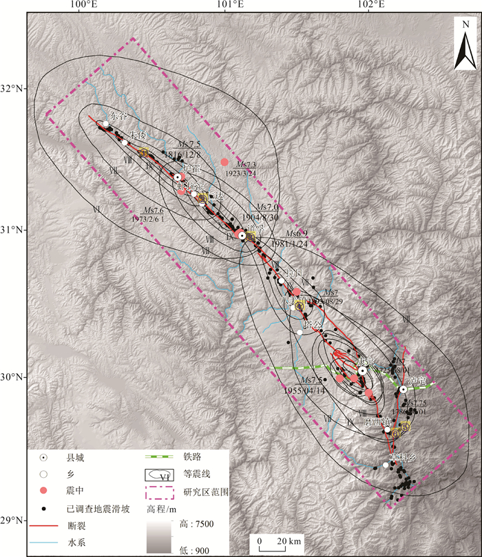
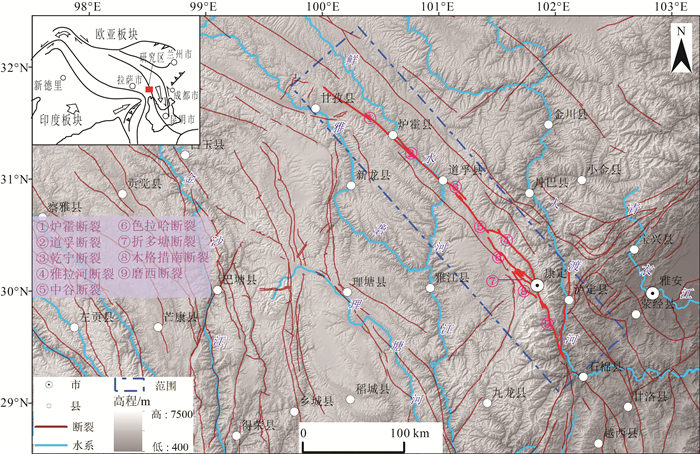
鲜水河断裂带平均海拔在3000 m以上,地形起伏度在1000 m/km2以上,坡度多处于20°~40°,为典型的高山峡谷地区。研究区气候垂直分带较明显,降雨量区域分布差异较大。鲜水河断裂带由炉霍断裂、道孚断裂、乾宁断裂、雅拉河断裂、中谷断裂、色拉哈-康定断裂、折多塘断裂、木格措南断裂和磨西断裂9条分支断裂组成(图 1),均为全新世活动断裂[17-18, 23-24, 30]。
自1725年至今,沿鲜水河断裂带发生8次Ms≥7级的强震,其中1973年发生的炉霍Ms 7.9级地震是鲜水河断裂带内有记载的震级最大的一次地震,距今最近的一次强震是1981年发生的道孚Ms 6.9级地震[23, 31]。2014年康定地区附近发生了Ms 5.9及Ms 5.6级2次地震,但释放的能量远小于自1955年康定Ms 7.5级地震以来积累的能量,研究认为,未来一段时间内在色拉哈-康定段具有产生Ms 6~7级以上强震的风险[24, 32]。
2. 鲜水河断裂带历史地震滑坡发育分布特征
2.1 地震滑坡空间分布特征
地震滑坡是由地震作用或地震力触发的一种滑坡类型,指地震震动引起岩体或土体沿一个缓倾面剪切滑移一定距离,斜坡岩体或土体脱离滑源区,瞬间失稳的一种地质现象[33-35]。由地震引起的地质灾害有时远超过地震作用本身造成的危害,如磨西Ms 73╱4地震、炉霍Ms 7.9地震都造成巨大的破坏,诱发大量的地震滑坡。历史记录和调查研究认为,鲜水河断裂带的地震滑坡主要分布在地震烈度Ⅷ~Ⅹ度区,空间上主要位于断裂带两侧2 km范围内[36]。结合野外地质调查和鲜水河断裂带地震滑坡的发育规律,可将断裂带分为3段,东谷—八美段河谷较宽,地震滑坡以蠕滑下错为主,后壁较明显,堆积层较薄,滑体主要由第四纪堆积物组成;在八美—康定段,八美土石林构造破碎和风化强烈,地质灾害发育,折多山段为高山风化冻融地貌,灾害发育较少;康定—磨西段河谷变窄,受大渡河及大渡河断裂的影响,滑坡较发育,堆积体主要为碎块石和第四纪堆积物。
较典型的1973年四川省炉霍县的Ms 7.9级地震,震源深度17 km,震中烈度Ⅹ度。地震造成2175人死亡,2756人受伤,极震区内房屋倒塌严重,崩塌、滑坡等地震次生地质灾害对公路交通造成了严重影响。由炉霍地震触发的滑坡有160多处[8, 37],多数集中分布于朱倭—仁达之间(图 2),在断裂带两侧各2 km的范围内其分布与地表破裂带高度重合,主要分布于地震烈度Ⅷ~Ⅹ度区,滑坡破坏形式以崩塌和溜滑为主,发生坡度主要为30°~50°[38]。
![]() 图 2 1973年炉霍Ms 7.9级地震地质灾害分布图[38]Figure 2. Distribution map of geological hazards during the Luhuo Ms 7.9 earthquake in 1973
图 2 1973年炉霍Ms 7.9级地震地质灾害分布图[38]Figure 2. Distribution map of geological hazards during the Luhuo Ms 7.9 earthquake in 19732.2 地震滑坡主要类型
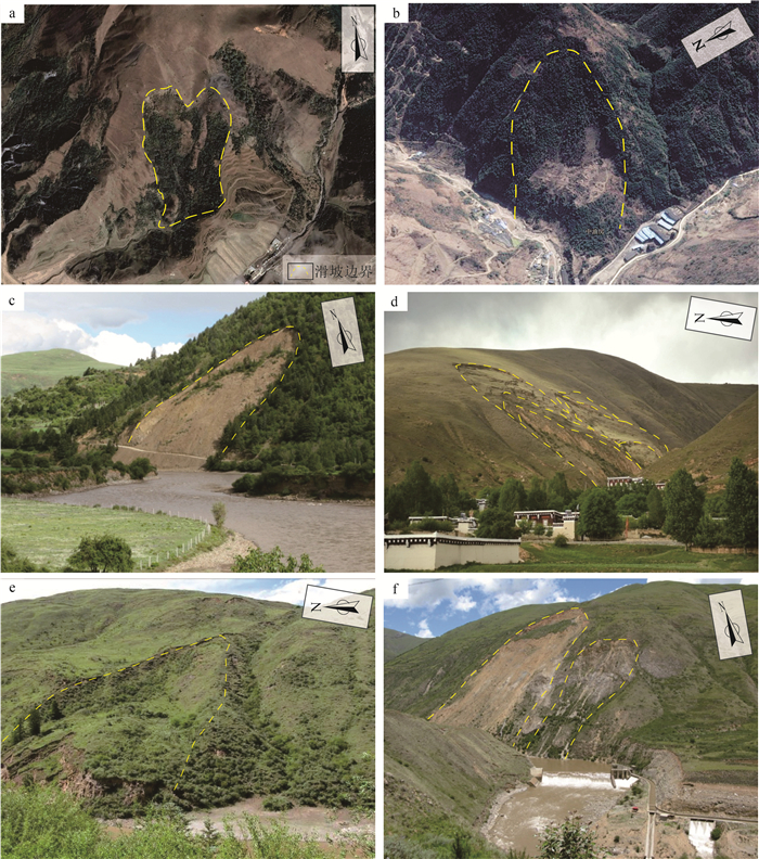
通过遥感解译、历史资料收集分析和1:5万地质灾害调查发现,在鲜水河断裂带两侧20 km范围内共有399处历史地震滑坡[38](图 3)。地震滑坡总体表现为高位远程、一滑到底、裂而未滑等特点。
(1) 高位远程滑坡
高位远程滑坡指滑体重心和剪出口位置高,滑坡剪出口与滑坡前缘的高差较大,滑源区岩体受山脊拉应力作用致使裂缝扩展,在中国青藏高原地区分布广泛,具有较大势能的滑坡,常伴有滑坡-堵江- 溃坝等链生地质灾害特征[39-40]。区内最典型的高位远程滑坡有八美镇幸福沟滑坡(图版Ⅰ-a)、摩岗岭滑坡等。幸福沟滑坡左侧以陡坎为界,右侧以冲沟为界,后缘以高陡基岩后壁为界,前缘以河流为界,滑动后已经挤压河道,该滑坡纵约130 m,宽约60 m,推测堆积体厚约10 m,体积约为7.8×10⁴ m3。
(2) 一滑到底型滑坡
一滑到底型滑坡是在地震震动的作用下,原来处于接近平衡的斜坡松散堆积物重心失稳,堆积体从坡顶启动,直达最低处的坡脚或河谷地区[37],如泸定县河口村河庄子滑坡(图版Ⅰ-b)和四十七道班滑坡(图版Ⅰ-c)。河庄子滑坡平面形态呈舌型,后缘以基岩为界,左右侧以下错陡坎为界,中部和前缘存在平台,滑坡纵长约620 m,宽350 m,厚约10 m,体积约为1.53×10⁶ m3,目前该滑坡稳定性较好。
(3) 裂而未滑型滑坡
裂而未滑型滑坡指在强烈的地震作用下,震区的山体发生大范围破裂,形成了大量拉裂缝,但整个山体松而未动、裂而未滑,处于临界稳定状态,在外力作用下极易发生滑动[41]。如道孚县东南足湾村滑坡为典型的裂而未滑型滑坡,该滑坡拉裂缝极发育,稳定性较差,在强降雨或地震作用下,极易发生滑动[36]。
2.3 典型地震滑坡发育特征
(1) 摩岗岭高位远程滑坡-堵江-溃坝灾害链
摩岗岭滑坡位于四川省泸定县大渡河右岸,鲜水河断裂带的分支断裂磨西断裂从滑体中部穿过,由1786年6月1日Ms 73╱4级地震诱发形成[25, 36]。该滑坡后缘呈典型圈椅状,地震的强大动力作用,使坡体后壁的岩体被抛射到大渡河左岸,堆积体体积约1.8×10⁸m3(图 4)。滑坡造成大渡河堵塞,在堰塞坝堵断大渡河9天后发生溃决,形成的泥石流、洪水造成石棉县城境内数万人死亡[25, 36, 42]。
![]() 图 4 摩岗岭滑坡全貌图和工程地质剖面图a—摩岗岭滑坡全貌图(镜像SWW);b—摩岗岭工程地质剖面图[25]Figure 4. The overall picture and engineering geological profile of the Mogangling landslide
图 4 摩岗岭滑坡全貌图和工程地质剖面图a—摩岗岭滑坡全貌图(镜像SWW);b—摩岗岭工程地质剖面图[25]Figure 4. The overall picture and engineering geological profile of the Mogangling landslide(2) 炉霍55道班滑坡
55道班滑坡位于四川省炉霍县317国道附近,鲜水河断裂带分支断裂从坡体中部穿过,后壁高陡,为典型的地震滑坡[8, 39]。该滑坡平面形态呈舌型,滑坡体积约1000×104m3,滑坡规模为特大型,在平面上分为Ⅰ区、Ⅱ区和Ⅲ区3个区域(图 5)。目前滑坡北侧前缘变形破坏迹象明显,整体稳定性差,坡体中下部发育拉裂缝,引起地面隆起、挡墙开裂和317国道改线绕行[36]。
![]() 图 5 55道班滑坡典型地貌图和工程地质平面图a—55道班滑坡工程地质平面图[36];b—55道班滑坡发育全貌图(镜像NW); Qh—冰川冰水堆积物;Qp—残坡积物;T3y1—变质砂岩夹板岩;T3ln2—砂板岩互层;T3ln1—变质砂岩夹板岩、砾岩;T3r2—玄武岩、凝灰岩、板岩;T3r1—板岩夹薄层变质砂岩;T2z2—变质砂岩夹板岩;T2z1—变质砂岩、板岩、灰岩;T1b—板岩、灰岩、角砾岩Figure 5. Typical geomorphological map and engineering geological plan of the 55 Daoban landslide
图 5 55道班滑坡典型地貌图和工程地质平面图a—55道班滑坡工程地质平面图[36];b—55道班滑坡发育全貌图(镜像NW); Qh—冰川冰水堆积物;Qp—残坡积物;T3y1—变质砂岩夹板岩;T3ln2—砂板岩互层;T3ln1—变质砂岩夹板岩、砾岩;T3r2—玄武岩、凝灰岩、板岩;T3r1—板岩夹薄层变质砂岩;T2z2—变质砂岩夹板岩;T2z1—变质砂岩、板岩、灰岩;T1b—板岩、灰岩、角砾岩Figure 5. Typical geomorphological map and engineering geological plan of the 55 Daoban landslide3. 基于Newmark模型的地震滑坡危险性评价
地震滑坡危险性评价指将地震作为潜在不确定因素,分析潜在地震及其诱发滑坡的时空分布概率,具体的危险性描述要素包括潜在地震滑坡的位置、体积或面积、滑坡类型和运移速度,以及一定时期内的发生概率等[43-44]。地震滑坡危险性评价的研究逐渐从定性向半定量、定量化发展,主要有基于统计分析的综合评价法[43-44]、基于极限平衡理论的拟静力法[45-47]、基于边坡累积位移的Newmark模型方法[48-50]。其中,Newmark方法适用于发震构造清楚或地震动强度和参数记录较完整的情况,注重震后对地震滑坡影响要素分析和危险性反演评估[44]。因此,本文采用Newmark模型开展鲜水河断裂带地震滑坡危险性评价。
3.1 Newmark斜坡位移模型
Newmark斜坡位移模型是英国科学家Newmark于1965年基于无限斜坡的极限平衡理论提出的一种地震滑坡危险性评价方法[48]。该模型把滑体看作是一个刚体,对坡体的静态安全系数和临界加速度进行研究,当外力的作用低于临界加速度时,坡体不会发生位移;当外力的作用高于临界加速度时,会出现有限位移;在地震作用下,则会产生滑动的永久位移。通过二次积分外载荷加速度和临界加速度的差值,即可获得永久位移(公式(1))[48, 51-53]。
Dn=∫t∫t[a(t)−ac]dts (1) 本文采用概率地震条件下的地震动峰值加速度作为潜在地震参数,采用的地震滑坡危险性计算步骤主要有:①利用岩土体力学参数和斜坡坡度,计算斜坡静态安全系数(Fs);②利用斜坡静态安全系数(Fs)和坡度,计算获得斜坡临界加速度(ac);③利用斜坡临界加速度(ac)和地震动峰值地面加速度(PGA),计算概率地震扰动下的坡体累积位移(Dn);④根据斜坡位移和滑坡发生概率的统计规律,预测评价概率地震滑坡危险性[9, 50, 53];⑤最后,利用历史地震滑坡对地震滑坡危险性分区结果进行检验。鲜水河断裂带地震滑坡危险性评价流程图如图 6所示。
3.2 Newmark模型评价过程
(1) 静态安全系数(Fs)
根据基于滑块极限平衡理论的斜坡安全系数公式(公(2))[49, 53],利用岩土体物理力学参数和坡度,计算得到斜坡静态安全系数(Fs)。
Fs=c′γtsinα+tanφ′tanα−mγwtanφ′γtanα=c′γtsinα+(1−mγwγ)×tanφ′tanα (2) 式中:c'为粘聚力(kPa);φ'为有效内摩擦角(°);γ为岩体重度(kN/m3);γw为地下水重度(kN/m3);t为潜在滑体厚度(m);α为潜在滑面倾角(°);m为潜在滑体中饱和部分占总滑体厚度的比例。
(2) 斜坡临界加速度(ac)
斜坡临界加速度(ac)指在地震作用下,滑块的下滑力与抗滑力相等时对应的地震动加速度。通过比较无外力作用和地震作用下滑块的受力状态,建立滑块在地震作用下的极限平衡状态方程,利用安全系数(Fs)推导出ac的计算公式(公(3))[54]。
ac=(Fs−1)gsinα (3) 式中:g为重力加速度(m/s2);α为滑面倾角(°)。
(3) 地震诱发斜坡位移(Dn)
通过分析大量地震加速度记录和地震滑坡实例,获得地震诱发斜坡累积位移(Dn)与临界加速度(ac)和地震动峰值加速度(PGA)的相互关系式(公式(4))[55]。其中,斜坡累积位移(Dn)与地震动峰值地面加速度强度(PGA)成正比,与斜坡临界加速度(ac)成反比[56]。采用中国第五代地震动峰值地面加速度计算鲜水河断裂带区域50年超越概率10%地震诱发斜坡位移(Dn)。
lgDn=0.215+log[(1−acPGA)2.341(aiPGA)−1.438] (4) 式中:ac为斜坡临界加速度;PGA为地震动峰值加速度。
(4) 地震诱发滑坡危险性(P)
地震诱发斜坡位移并不一定会发生坡体滑动,只有当斜坡位移累积到一定程度时,坡体才会发生失稳,并沿滑动面下滑产生滑坡灾害。因此,根据地震斜坡位移和滑坡发生概率之间的相关关系(公式(5))[49],计算地震作用下的滑坡发生概率(P)。
P=0.335[1−exp(−0.048D1.565n)] (5) 式中:Dn为斜坡位移。
4. 鲜水河断裂带地震滑坡危险性评价结果
4.1 地震滑坡危险性计算
(1) 地形坡度
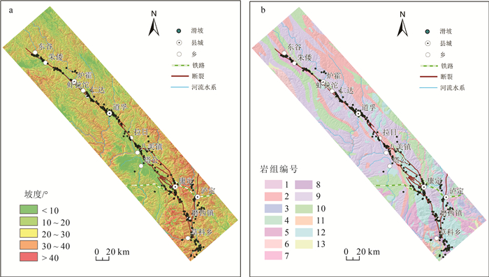
据地震滑坡危险性评估经验,地形坡度小于10°的斜坡通常较稳定,很少发生大规模的滑坡,因此,地形坡度小于10°的斜坡不参与计算[27-28]。研究区的地形坡度起伏较大,大渡河流域、鲜水河流域等地坡度较大(图 7-a)。
![]() 图 7 鲜水河断裂带地形坡度和工程地质岩组(岩组编号见表 1中ID)a—地形坡度分布图;b—工程地质岩组分布图Figure 7. Topographic slope and engineering geological rock group of Xianshuihe fault zone表 1 鲜水河断裂带工程地质岩组与物理力学参数Table 1. Physical and mechanical properties of engineering geological rock groups in the Xianshuihe fault zone
图 7 鲜水河断裂带地形坡度和工程地质岩组(岩组编号见表 1中ID)a—地形坡度分布图;b—工程地质岩组分布图Figure 7. Topographic slope and engineering geological rock group of Xianshuihe fault zone表 1 鲜水河断裂带工程地质岩组与物理力学参数Table 1. Physical and mechanical properties of engineering geological rock groups in the Xianshuihe fault zoneID 工程地质岩组名称 c'/kPa ϕ'/° γ/(kN·m-3) 1 坚硬的厚层状砂岩岩组 26 33 26 2 较坚硬—坚硬的中—厚层状砂岩夹砾岩、泥岩、板岩岩组 25 32 25 3 软硬相间的中—厚层状砂岩、泥岩夹灰岩、泥质灰岩及其互层岩组 25 32 24 4 软弱—较坚硬薄—中厚层状砂、泥岩及砾、泥岩互层岩组 20 27 23 5 软弱的薄层状泥、页岩岩组 24 31 21 6 坚硬的中—厚层状灰岩及白云岩岩组 23 31 25 7 较坚硬的薄—中厚层状灰岩、泥质灰岩岩组 23 30 24 8 软硬相间的中—厚层状灰岩、白云岩夹砂、泥岩、千枚岩、板岩岩组 22 29 23 9 较坚硬—坚硬薄—中厚层状板岩、千枚岩与变质砂岩互层岩组 21 28 22 10 较弱—较坚硬的薄—中厚层状千枚岩、片岩夹灰岩、砂岩、火山岩岩组 28 35 21 11 坚硬的块状玄武岩为主的岩组 27 34 29 12 坚硬块状花岗岩、安山岩、闪长岩岩组 19 26 28 13 软质散体结构岩组 15 25 18 注:ID与图 7-b中的工程地质岩组号码一致,c'为粘聚力,φ'为有效内摩擦角,γ为岩体重度 (2) 工程地质岩组划分
综合考虑地质构造、地层年代、岩土体类型、岩体风化破碎程度等因素,将鲜水河断裂带地层岩性划分为13个工程地质岩组。根据《工程地质手册》 (第五版)[56],结合区内地层岩性分布与典型岩体的力学强度测试结果,获得工程地质岩组的物理力学参数。
(3) 静态斜坡安全系数计算
采用公式(2)计算静态安全系数(Fs),通过多次迭代循环计算,调整模型参数,使斜坡在无外力作用下的斜坡静态安全系数(Fs)大于1。因地形坡度小于10°的斜坡通常十分稳定,本文相应区域的斜坡不进行静态安全系数的计算,以此确定模型参数为:c'、φ'和γ。其中,C'为粘聚力,φ'为有效内摩擦角,r为岩体重度,具体参数值见表 1,γw=10kN/m3,t=2.5m,m=0.3,α取值为地形坡度(图 7-a)。计算得到的鲜水河断裂带斜坡静态安全系数(Fs)见图 8-a,具有较低静态安全性的斜坡沿深切河谷分布,总体上呈现北北东向;具有静态安全性较高的斜坡主要分布在地形坡度较缓的地区,如塔公草原附近静态安全系数大于5。
(4) 鲜水河断裂带临界加速度计算
据公式(3)利用静态安全系数(Fs)和斜坡坡度计算得到鲜水河断裂带斜坡临界加速度(ac)(图 8-b),与静态安全系数相对应,坡度越高的地区其稳定性越差,即静态安全系数越低,诱发斜坡失稳所需的临界加速度越小。在坡度较陡的斜坡上,临界加速度小于0.15 g,在坡度较缓的河谷、盆地和塔公草原,临界加速度大于0.6 g,最大值可达到0.98 g。
(5) 地震动峰值加速度
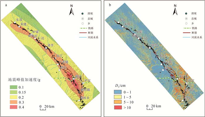
地震动峰值加速度用于计算地震诱发斜坡位移,采用中国第五代地震动峰值地面加速度分区值来计算鲜水河断裂带区域地震诱发斜坡位移(Dn)。据图 9-a显示,随着距离鲜水河断裂带越远,地震动峰值加速度值减小,在康定附近达到最大值0.4 g。
(6) 鲜水河断裂带斜坡位移计算
给定斜坡一个地震动值,当临界加速度相同时,斜坡将产生相同的位移[27]。根据式(4)计算得到鲜水河断裂带斜坡位移(Dn)。结果显示,斜坡位移较大的区域主要分布在临界加速度较小和地震动峰值加速度较大的区域,即康定—磨西段、大渡河流域及坡度较大的地区,位移可达10 cm以上(图 9-b)。
4.2 危险性分区与结果检验
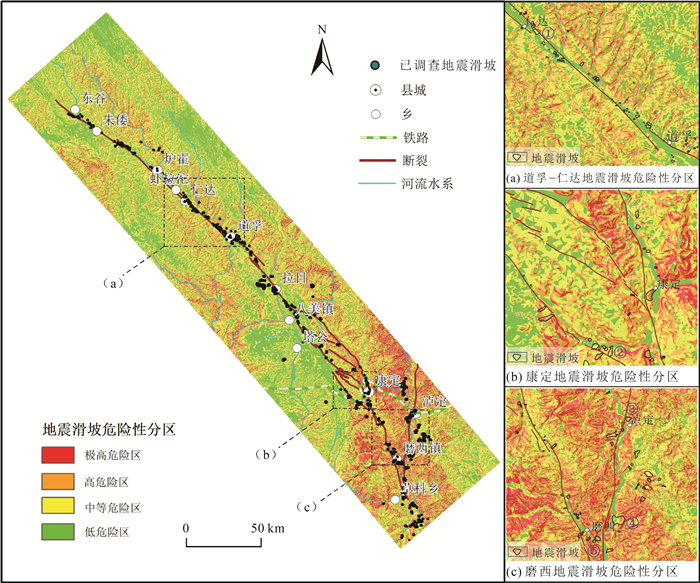
利用Newmark模型计算获得鲜水河断裂带地震滑坡危险性分区,根据地震滑坡发生概率,参考《地质灾害危险性评估规范》(DZ/T 0286—2015)和国内外地震滑坡危险性分区研究成果[49],进一步把鲜水河断裂带划分为地震滑坡低危险区、中等危险区、高危险区和极高危险区(图 10),并统计历史地震滑坡在各分区中的分布(表 2)。结合已有地震滑坡点验证,各分区特点如下。
表 2 地震滑坡危险性分级统计Table 2. Seismic landslide hazards classification statistics地震滑坡危险区 分级面积/km2 分级面积比例/% 已发现的地震滑坡 滑坡数量/个 滑坡数量比例/% 滑坡面积/km2 滑坡面积比例/% 极高危险区 1931 6.28 140 35.09 57.76 70.62 高危险区 3619 11.77 114 28.57 15.34 18.75 中等危险区 10249 33.33 108 27.07 8.36 10.21 低危险区 14951 48.62 37 9.27 0.34 0.42 (1) 地震滑坡低危险区约占研究区面积的48.62%,主要分布在地形坡度较缓的东谷附近河谷地区及塔公草原地区,约有9.27%已调查发现的滑坡分布在地震滑坡低危险区。
(2) 地震滑坡中等危险区约占研究区面积的33.33%,约有27.07%已调查发现的滑坡分布在地震滑坡中等危险区,主要分布在鲜水河断裂带北段鲜水河河谷两侧坡度较缓的斜坡(图 10-a)。
(3) 地震滑坡高危险区约占研究区面积的11.77%,约有28.57%已调查发现的滑坡分布在地震滑坡高危险区,地震滑坡高危险区主要分布在康定市及周边地区(图 10-b)。
(4) 地震滑坡极高危险区约占区域面积的6.28%,约有35.09%已调查发现的滑坡分布在地震滑坡极高危险区,地震滑坡极高危险区主要分布在坡度较陡的大渡河流域和康定—磨西段(图 10-c)。
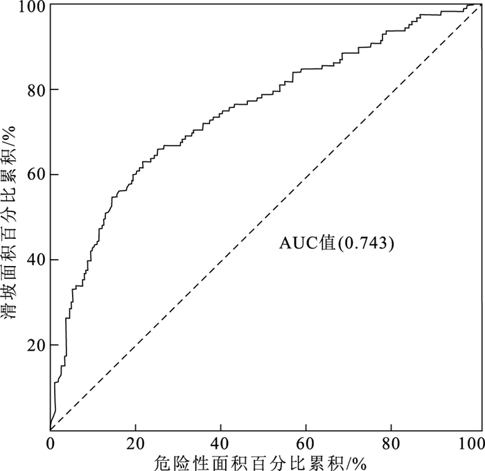
本文采用地质灾害危险性评价常用的成功率(ROC)曲线方法,对鲜水河断裂带地震滑坡危险性评价结果进行检验。ROC曲线下的面积值(AUC)越接近1.0,说明模型的构建效果越好,即评价结果越好;相反,若AUC值越接近0.5,说明模型的准确性越低[57]。本次鲜水河断裂带滑坡危险性评价结果的ROC曲线下方面积值为0.743(图 11),表明基于Newmark模型的鲜水河断裂带地震滑坡危险性评价结果具有较好的精度。
5. 讨论
5.1 鲜水河断裂带地震滑坡趋势
分析表明,已调查发现的399处历史地震滑坡主要沿地震动峰值加速度较高的区域分布。基于Newmark模型计算获得地震滑坡危险性分区,结果显示,有63.66%的地震滑坡分布在极高危险和高危险区。地震滑坡的发生受地震震级、震源深度、地形地貌、工程地质条件等因素影响。鲜水河断裂带构造活动强烈、工程地质条件较差,根据野外地质调查和地震滑坡危险性评价结果,鲜水河断裂带东南段的地震滑坡危险性较高。
前人研究认为,色拉哈-康定具有产生Ms 6~7级以上地震的风险[24, 32]。以上地震滑坡危险性评价结果显示,若沿鲜水河断裂带发生Ms 7.0级及以上强震,则康定周边、大渡河流域及康定—磨西段有较高的地震滑坡危险性。
5.2 鲜水河断裂带地震滑坡预测方法
王涛等[41]利用地震地质灾害形成和演化规律,提出广义的地震滑坡危险性评估框架。历史地震滑坡重点关注研究区历史强震,利用Newmark模型对历史地震诱发滑坡位移进行评估;同震滑坡的评估则是利用基础地质调查、遥感解译、地震动等参数,开展区域同震滑坡危险性评估;震后降雨滑坡结合地质灾害易发性进行地质灾害危险性评估[58];潜在地震滑坡主要依靠概率地震危险性分析方法,综合考虑区域工程地质条件与发震环境的相互作用,利用Newmark模型进行潜在地震滑坡危险性评估[59]。
层次分析法、信息量模型、加权线性叠加、支持向量机、逻辑回归等统计分析方法,具有数据量过大、不适合面积较大区域,忽视了与灾害问题的对应关系和适用条件等不足[60]。Newmark模型适用于发震构造清楚或地震动强度和参数记录较完整的情况,注重震后对地震滑坡影响要素的分析和危险性反演评估[44],可以利用中国第五代地震动峰值加速度计算当前地震动加速度下的潜在地震滑坡危险性,也可以通过阿里亚斯烈度(Arias)计算某次历史地震或设置的潜在地震点下的地震滑坡危险性。本文在考虑区域地震地质背景的基础上,基于Newmark模型方法的定量化评价优势,采用该方法开展鲜水河断裂带地震滑坡危险性评价。通过对比鲜水河断裂带地震滑坡危险性评估结果与区内历史地震滑坡分布,发现历史地震滑坡分布密集的区域与危险性评估结果中的极高危险区和高危险区分布较一致。
5.3 对重大工程规划建设的影响
鲜水河断裂带地处四川省境内川西地区,活动性强,未来具有发生强震的可能性[24]。根据鲜水河断裂带地震滑坡危险性评估结果显示,地震滑坡极高和高危险区主要分布在坡度较陡的大渡河流域和康定—磨西段、康定市及周边地区,研究区约有63.66%的历史地震滑坡分布在地震滑坡极高和高危险区。研究区城镇、公路等沿鲜水河、大渡河密集分布,且沿岸又是地质灾害高发区,部分居民点和公路存在地质灾害风险,城镇规划区应远离地震滑坡高危险区、河谷岸坡等地区;重要入藏公路G318穿越鲜水河断裂带地震滑坡高危险区,受到地质灾害严重威胁,需加强潜在地震诱发地质灾害防控意识、防护排查等处置措施;并且该区正在规划建设川藏铁路等重大工程,铁路建设面临地震滑坡的风险极高,规划铁路线经泸定县、康定市地震滑坡危险性较高的地区,但该路段以隧道为主,因此,铁路等工程规划建设需加强二郎山隧道、宝灵山隧道、郭达山隧道、康定隧道等的进出口地震滑坡危害评判及防控。
6. 结论
(1) 地震滑坡极高危险性区、高危险区、中等危险区和低危险区分别占研究区总面积的6.28%、11.77%、33.33%和48.62%,危险性较高的地区主要分布在康定—磨西段、大渡河附近及坡度较陡的斜坡上。
(2) 通过对比地震滑坡危险性评价结果与历史地震滑坡分布,发现已调查的399处地震滑坡有254处地震滑坡分布在地震滑坡极高和高危险区,与评估揭示的极高—高危险区分布较吻合,成功率(ROC)曲线检验结果显示,地震滑坡危险性评价的准确率为74.3%,评价结果精确度较高。
(3) 地震滑坡危险性分区受活动断裂和地形地貌影响显著,距离断层越近、坡度越大的斜坡,地震滑坡危险性越高。
(4) 根据危险性分区结果,若鲜水河断裂带发生强震,在大渡河流域及康定-磨西段有较高的危险性。川藏铁路经泸定县、康定地震滑坡危险性较高的地区,在铁路建设需加强铁路隧道口附近的地震滑坡危害评判及防控。
致谢: 中国地质科学院地质力学研究所吴瑞安副研究员,金继军、师宗锐、袁浩和倪嘉伟硕士研究生参加了部分野外地质调查工作,在此一并表示感谢。 -
图 2 1973年炉霍Ms 7.9级地震地质灾害分布图[38]
Figure 2. Distribution map of geological hazards during the Luhuo Ms 7.9 earthquake in 1973
图 4 摩岗岭滑坡全貌图和工程地质剖面图
a—摩岗岭滑坡全貌图(镜像SWW);b—摩岗岭工程地质剖面图[25]
Figure 4. The overall picture and engineering geological profile of the Mogangling landslide
图 5 55道班滑坡典型地貌图和工程地质平面图
a—55道班滑坡工程地质平面图[36];b—55道班滑坡发育全貌图(镜像NW); Qh—冰川冰水堆积物;Qp—残坡积物;T3y1—变质砂岩夹板岩;T3ln2—砂板岩互层;T3ln1—变质砂岩夹板岩、砾岩;T3r2—玄武岩、凝灰岩、板岩;T3r1—板岩夹薄层变质砂岩;T2z2—变质砂岩夹板岩;T2z1—变质砂岩、板岩、灰岩;T1b—板岩、灰岩、角砾岩
Figure 5. Typical geomorphological map and engineering geological plan of the 55 Daoban landslide
图 7 鲜水河断裂带地形坡度和工程地质岩组(岩组编号见表 1中ID)
a—地形坡度分布图;b—工程地质岩组分布图
Figure 7. Topographic slope and engineering geological rock group of Xianshuihe fault zone
表 1 鲜水河断裂带工程地质岩组与物理力学参数
Table 1 Physical and mechanical properties of engineering geological rock groups in the Xianshuihe fault zone
ID 工程地质岩组名称 c'/kPa ϕ'/° γ/(kN·m-3) 1 坚硬的厚层状砂岩岩组 26 33 26 2 较坚硬—坚硬的中—厚层状砂岩夹砾岩、泥岩、板岩岩组 25 32 25 3 软硬相间的中—厚层状砂岩、泥岩夹灰岩、泥质灰岩及其互层岩组 25 32 24 4 软弱—较坚硬薄—中厚层状砂、泥岩及砾、泥岩互层岩组 20 27 23 5 软弱的薄层状泥、页岩岩组 24 31 21 6 坚硬的中—厚层状灰岩及白云岩岩组 23 31 25 7 较坚硬的薄—中厚层状灰岩、泥质灰岩岩组 23 30 24 8 软硬相间的中—厚层状灰岩、白云岩夹砂、泥岩、千枚岩、板岩岩组 22 29 23 9 较坚硬—坚硬薄—中厚层状板岩、千枚岩与变质砂岩互层岩组 21 28 22 10 较弱—较坚硬的薄—中厚层状千枚岩、片岩夹灰岩、砂岩、火山岩岩组 28 35 21 11 坚硬的块状玄武岩为主的岩组 27 34 29 12 坚硬块状花岗岩、安山岩、闪长岩岩组 19 26 28 13 软质散体结构岩组 15 25 18 注:ID与图 7-b中的工程地质岩组号码一致,c'为粘聚力,φ'为有效内摩擦角,γ为岩体重度 表 2 地震滑坡危险性分级统计
Table 2 Seismic landslide hazards classification statistics
地震滑坡危险区 分级面积/km2 分级面积比例/% 已发现的地震滑坡 滑坡数量/个 滑坡数量比例/% 滑坡面积/km2 滑坡面积比例/% 极高危险区 1931 6.28 140 35.09 57.76 70.62 高危险区 3619 11.77 114 28.57 15.34 18.75 中等危险区 10249 33.33 108 27.07 8.36 10.21 低危险区 14951 48.62 37 9.27 0.34 0.42 -
许强, 董秀军, 李为乐. 基于天-空-地一体化的重大地质灾害隐患早期识别与监测预警[J]. 武汉大学学报, 2019, 44(7): 957-966. https://www.cnki.com.cn/Article/CJFDTOTAL-WHCH201907002.htm 郭长宝, 倪嘉伟, 杨志华, 等. 川西大渡河泸定段大型古滑坡发育特征与稳定性评价[J]. 地质通报, 2021, 40(12): 1981-1991. http://dzhtb.cgs.cn/gbc/ch/reader/view_abstract.aspx?file_no=20211201&flag=1 黄润秋. 中国西部地区典型岩质滑坡机理研究[J]. 地球科学进展, 2004, 19(3): 443-450. doi: 10.3321/j.issn:1001-8166.2004.03.016 徐正宣, 张利国, 蒋良文, 等. 川藏铁路雅安至林芝段工程地质环境及主要工程地质问题[J]. 工程科学与技术, 2021, 53(3): 29-42. https://www.cnki.com.cn/Article/CJFDTOTAL-SCLH202103005.htm 张怡颖, 郭长宝, 杨志华, 等. 四川巴塘扎马古滑坡发育特征与复活趋势[J]. 地质通报, 2021, 40(12): 2002-2014. http://dzhtb.cgs.cn/gbc/ch/reader/view_abstract.aspx?file_no=20211203&flag=1 李忠生. 国内外地震滑坡灾害研究综述[J]. 灾害学, 2003, (4): 65-71. https://www.cnki.com.cn/Article/CJFDTOTAL-ZHXU200304013.htm 殷跃平. 汶川八级地震地质灾害研究[J]. 工程地质学报, 2008, (4): 433-444. doi: 10.3969/j.issn.1004-9665.2008.04.001 王东辉, 田凯. 鲜水河断裂带炉霍段地震滑坡空间分布规律分析[J]. 工程地质学报, 2014, 22(2): 292-299. https://www.cnki.com.cn/Article/CJFDTOTAL-GCDZ201402018.htm 杨志华, 兰恒星, 张永双, 等. 强震区震后地质灾害长期活动性研究综述[J]. 地质力学学报, 2017, 23(5): 743-753. doi: 10.3969/j.issn.1006-6616.2017.05.011 Keefer D K. Landslides caused by earthquakes[J]. Geological Society of America Bulletin, 1984, 95(4): 406-421. doi: 10.1130/0016-7606(1984)95<406:LCBE>2.0.CO;2
孙崇绍, 蔡红卫. 我国历史地震时滑坡崩塌的发育及分布特征[J]. 自然灾害学报, 1997, (1): 27-32. https://www.cnki.com.cn/Article/CJFDTOTAL-ZRZH701.004.htm 丁彦慧, 王余庆, 孙进忠, 等. 地震崩滑预测方法及其工程应用研究[J]. 工程地质学报, 2000, (4): 475-480. doi: 10.3969/j.issn.1004-9665.2000.04.016 Xu C, Xu X, Yao X, et al. Three (nearly) complete inventories of landslides triggered by the May 12, 2008Wenchuan Mw 7.9 earthquake of China and their spatial distribution statistical analysis[J]. Landslides, 2014, 11(3): 441-461. doi: 10.1007/s10346-013-0404-6
张铎, 吴中海, 李家存, 等. 国内外地震滑坡研究综述[J]. 地质力学学报, 2013, 19(3): 225-241. doi: 10.3969/j.issn.1006-6616.2013.03.001 王涛, 刘甲美, 栗泽桐, 等. 中国地震滑坡危险性评估及其对国土空间规划的影响研究[J]. 中国地质, 2021, 48(1): 21-39. https://www.cnki.com.cn/Article/CJFDTOTAL-DIZI202101003.htm 杨志华, 郭长宝, 吴瑞安, 等. 青藏高原巴塘断裂带地震滑坡危险性预测研究[J]. 水文地质工程地质, 2021, 48(5): 91-101. https://www.cnki.com.cn/Article/CJFDTOTAL-SWDG202105010.htm 许志琴, 李化启, 侯立炜, 等. 青藏高原东缘龙门-锦屏造山带的崛起——大型拆离断层和挤出机制[J]. 地质通报, 2007, (10): 1262-1276. doi: 10.3969/j.issn.1671-2552.2007.10.005 Roger F, Calassou S, Lancelot J, et al. Miocene emplacement and deformation of the Konga Shan granite (Xianshui He fault zone, west Sichuan, China): Geodynamic implications[J]. Earth and Planetary Science Letters, 1995, 130(1/4): 201-216. https://www.sciencedirect.com/science/article/pii/0012821X9400252T
钱洪. 鲜水河断裂带上潜在震源区的地质学判定[J]. 四川地震, 1988, (2): 20-28. https://www.cnki.com.cn/Article/CJFDTOTAL-SCHZ198802004.htm 李海兵, 许志琴, 杨经绥. 青藏高原北缘和东缘造山带的崛起及造山机制[C]//许志琴, 杨经绥, 李海滨, 等. 造山的高原. 北京: 地质出版社, 2007: 276-294. 张岳桥, 陈文, 杨农. 川西鲜水河断裂带晚新生代剪切变形40Ar/39Ar测年及其构造意义[J]. 中国科学, 2004, (7): 613-621. https://www.cnki.com.cn/Article/CJFDTOTAL-JDXK200407002.htm 熊探宇, 姚鑫, 张永双. 鲜水河断裂带全新世活动性研究进展综述[J]. 地质力学学报, 2010, 16(2): 176-188. doi: 10.3969/j.issn.1006-6616.2010.02.007 李天袑, 杜其方. 鲜水河活动断裂带及强震危险性评估[M]. 成都: 成都地图出版社, 1997. 潘家伟, 李海兵, Chevalier M L, 等. 鲜水河断裂带色拉哈-康定段新发现的活动断层: 木格措南断裂[J]. 地质学报, 2020, 94(11): 3178-3188. doi: 10.3969/j.issn.0001-5717.2020.11.002 张御阳. 强震触发摩岗岭滑坡成因机制及运动特性研究[D]. 成都理工大学硕士学位论文, 2013. 林高聪, 潘书华, 叶振南. 基于Newmark法的设定地震滑坡危险性评估[J]. 桂林理工大学学报, 2021, 41(3): 525-532. doi: 10.3969/j.issn.1674-9057.2021.03.006 李雪婧, 高孟潭, 徐伟进. 基于Newmark模型的概率地震滑坡危险性分析方法研究——以甘肃天水地区为例[J]. 地震学报, 2019, 41(6): 795-808. https://www.cnki.com.cn/Article/CJFDTOTAL-DZXB201906010.htm 杨志华, 张永双, 郭长宝, 等. 基于Newmark模型的尼泊尔Ms8.1级地震滑坡危险性快速评估[J]. 地质力学学报, 2017, 23(1): 115-124. https://www.cnki.com.cn/Article/CJFDTOTAL-DZLX201701007.htm 王涛, 吴树仁, 石菊松, 等. 基于简化Newmark位移模型的区域地震滑坡危险性快速评估——以汶川Ms 8.0级地震为例[J]. 工程地质学报, 2013, 21(1): 16-24. https://www.cnki.com.cn/Article/CJFDTOTAL-GCDZ201301004.htm Bai M K, Chevalier M L, Leloup P H, et al. Spatial Slip Rate Distribution Along the SE Xianshuihe Fault, Eastern Tibet, and Earthquake Hazard Assessment[J]. Tectonics, 2021: 1-14.
刘本培, 朱智勤, 廖华, 等. 鲜水河断裂带的构造大地测量[J]. 地壳形变与地震, 2001, (4): 17-25. https://www.cnki.com.cn/Article/CJFDTOTAL-DKXB200104002.htm Xu J, Shao Z G, Liu J, et al. Coulomb stress evolution and future earthquake probability along the eastern boundary of the Sichuan-Yunnan block[J]. Chinese Journal of Geophysics, 2019, 62(11): 4189-4213.
吴俊峰. 大渡河流域重大地震滑坡发育特征与成因机理研究[D]. 成都理工大学博士学位论文, 2013. 蒋宏毅, 杨凡, 左天惠, 等. 京津冀地区地震滑坡危险性评估[J]. 高原地震, 2021, 33(2): 38-43. https://www.cnki.com.cn/Article/CJFDTOTAL-GYDZ202102007.htm 周洪福, 方甜, 韦玉婷. 国内外地震滑坡研究: 现状、问题与展望[J/OL]. 沉积与特提斯地质: 1-12[2022-02-15]. DOI: 10.19826/j.cnki.1009-3850.2021.11011. 郭长宝, 杜宇本, 张永双, 等. 川西鲜水河断裂带地质灾害发育特征与典型滑坡形成机理[J]. 地质通报, 2015, 34(1): 121-134. https://www.cnki.com.cn/Article/CJFDTOTAL-ZQYD201501010.htm 李明辉, 王东辉, 高延超, 等. 鲜水河断裂带炉霍7.9级地震地质灾害研究[J]. 灾害学, 2014, 29(1): 37-41. https://www.cnki.com.cn/Article/CJFDTOTAL-ZHXU201401007.htm 郭长宝, 张永双, 杨志华, 等. 川藏铁路沿线活动断裂与地质灾害效应调查研究[M]. 北京: 地质出版社, 2018: 211-215. 殷跃平. 汶川八级地震滑坡高速远程特征分析[J]. 工程地质学报, 2009, 17(2): 153-166. https://www.cnki.com.cn/Article/CJFDTOTAL-GCDZ200902002.htm 黄润秋, 李为乐. 5.12汶川大地震触发地质灾害的发育分布规律研究[J]. 岩石力学与工程学报, 2008, 27(12): 2585-2592. https://www.cnki.com.cn/Article/CJFDTOTAL-YSLX200812032.htm 许强. 汶川大地震诱发地质灾害主要类型与特征研究[J]. 地质灾害与环境保护, 2009, 20(2): 86-93. https://www.cnki.com.cn/Article/CJFDTOTAL-DZHB200902020.htm 周洪福, 韦玉婷, 王运生, 等. 1786年磨西地震触发的摩岗岭滑坡演化过程与成因机理[J]. 成都理工大学学报(自然科学版), 2017, 44(6): 649-658. https://www.cnki.com.cn/Article/CJFDTOTAL-CDLG201706002.htm Yang Z H, Lan H X, Gao X, et al. Urgent Landslide Susceptibility Assessment in the 2013 Lushan Earthquake-impacted Area, Sichuan Province, China[J]. Natural Hazards, 2015, 75(3): 2467-2487.
王涛, 吴树仁, 石菊松, 等. 地震滑坡危险性概念和基于力学模型的评估方法探讨[J]. 工程地质学报, 2015, 23(1): 93-104. https://www.cnki.com.cn/Article/CJFDTOTAL-GCDZ201501019.htm 巩留杰. 基于有限元计算的边坡稳定极限平衡法研究[D]. 湖南大学硕士学位论文, 2012. 王学鹏. 滑坡体稳定分析的极限平衡法与有限元法对比研究[D]. 昆明理工大学硕士学位论文, 2015. 赵博雅. 基于有限元极限平衡法的边坡可靠度分析[D]. 大连理工大学硕士学位论文, 2017. Newmark N M. Effects of earthquakes on dams and embankments[J]. Geotechnique, 1965, 15(2): 139-160.
Jibson R W, Harp E L, Michael J A. A method for producing digital probabilistic seismic landslide hazard maps[J]. Engineering Geology, 2000, 58(3/4): 271-289. https://www.sciencedirect.com/science/article/pii/S0013795200000399
Zhang Y S, Yang Z H, Guo C B, et al. Predicting landslide scenes under potential earthquake scenarios in the Xianshuihe fault zone, Southwest China[J]. Journal of Mountain Science, 2017, 14(7): 1262-1278. doi: 10.1007/s11629-017-4363-6
Jibson R W. Predicting earthquake-induced landslide displacements using Newmark's sliding block analysis[J]. Transportation Research Record, 1993, 1411: 9-17.
Roberto R. Seismically induced landslide displacements: a predictivemodel[J]. Engineering Geology, 2000, 58(3/4): 337-351.
Miles S B., Ho C l. Rigorous landslide hazard zonation using Newmark's method and stochastic ground motion simulation[J]. Soil Dynamics and Earthquake Engineering, 1999, 18: 305-323.
Wilson R C, Keefer D K. Dynamic analysis of a slope failure from the 6 August 1979 Coyote lake, California, earthquake[J]. Bulletin of the Seismological Society of America, 1983, 73(3): 863-877.
Jibson R W. Regression models for estimating coseismic landslide displacement[J]. Engineering Geology, 2007, 91(2/3): 209-218. https://www.sciencedirect.com/science/article/pii/S0013795207000300
工程地质手册(第五版)[M]. 北京, 中国建筑工业出版社, 2018. 闫怡秋, 杨志华, 张绪教, 等. 基于加权证据权模型的青藏高原东部巴塘断裂带滑坡易发性评价[J]. 现代地质, 2021, 35(1): 26-37. https://www.cnki.com.cn/Article/CJFDTOTAL-XDDZ202101004.htm 王涛. 汶川地震重灾区地质灾害危险性评估研究[D]. 中国地质科学院博士学位论文, 2010. 刘静伟. 基于历史地震烈度资料的地震危险性评估方法研究[D]. 中国地震局地质研究所博士学位论文, 2011. 马思远. 基于Newmark模型的地震滑坡危险性评价研究[D]. 中国地震局地质研究所硕士学位论文, 2018. -
期刊类型引用(1)
1. 吴浩,徐祖阳,严维兵,郝宇杰,刘海永. 西藏中部聂尔错地区辉绿岩锆石U-Pb年龄与地球化学特征:对新特提斯洋板片断离的指示. 中国地质. 2023(06): 1804-1816 .  百度学术
百度学术
其他类型引用(0)


 下载:
下载:

