Recognition and identification of spatial mineralization patterns
-
摘要:
使用现代信息技术,基于空间数据圈定矿化分布和找矿目标,是当前矿产勘查的一个新方向。采用模糊聚类方法,以地质、地球物理和地球化学图层为输入数据,在GIS平台上对空间矿化模式进行识别,并通过地质解读从中鉴别出矿化模式。模糊聚类是基于c-means聚类的人工神经网络方法,以模糊隶属度作为不确定性推理指标,是一种非监督分类器。用这一方法进行空间矿化模式识别,可以在多种矿床类型共存和交叉重叠分布的环境中,识别并鉴别出个性化的矿化模式。以内蒙古乌兰浩特1:20万图幅为例,展示了模糊聚类空间矿化模式的识别与鉴别过程,取得了良好的效果。
Abstract:A recent development in mineral exploration is the use of information technology to define the distribution of mineralization and prospecting targets using spatial data.With geological, geophysical, and geochemical map layers as input data, fuzzy clustering was used in this study to recognize spatial patterns on the GIS platform, and the mineralization patterns were identified by geological interpretation.Fuzzy clustering is a hybrid spatial pattern recognition method composed of c-means clustering, neural network and fuzzy sets.Being an unsupervised classifier, it uses fuzzy membership as an uncertain measurement of the spatial pattern recognition.In the complex distribution environment where diverse deposit types coexist and intersect, different individualized mineralization patterns can be recognized and identified.This study illustrates the technique of fuzzy clustering spatial mineralization pattern recognition and identification, with successful results, using the 1:200 000 map of Ulanhot, Inner Mongolia as an example.
-
随着信息技术的飞速发展,基于空间分析的矿化评价已成为矿产勘查的热点。矿产资源定量评价可以追溯到20世纪50年代[1]。到20世纪70年代,国外开始使用计算机进行矿产资源潜力评价;80—90年代,形成了以多元统计分析为主的、普遍使用计算机的评价方法体系[2-4]。在这个体系的支撑下,美国、加拿大和苏联广泛开展了矿产资源潜力评价工作,稍后中国也成为世界上开展资源潜力评价最活跃的国家之一。20世纪90年代后,转向各种基于GIS的空间分析方法。从21世纪初开始,使用的方法已不限于多元统计,进入使用不确定性推理(uncertain reasoning)和软计算(soft computing)[5-8]领域,如证据权法、模糊逻辑、证据理论、粗糙集、神经网络等,即把各种数学模型归纳为一种遵循人类思维逻辑的推理形式;但推理不是黑白两分,而是带有不确定性测度,如概率、可能性、隶属度等[9]。虽然仍然有部分方法具有概率统计性质,但在观念上已转变为以模拟人的思维逻辑为中心而不是以数学公式为中心,张尧庭等[10]在将评价公式转变为假言三段论推理形式方面做出了开创性的贡献。
人工智能或软计算,是实现不确定性推理的重要途径,在找矿勘查评价中具有广泛的应用前景。Looney[11]和Raines等[12]开发了针对找矿远景区和靶区评价的神经网络工具。他们提出的模糊聚类方法,是一种基于径向基函数和具有模糊隶属度不确定性测度的神经网络。其在应用上有2个重要特点:①这种方法属于非监督分类,无需已知矿床,这就为方法在未知区的应用提供了广阔的前景;②它不是针对固定矿床类型进行的空间矿化模式识别,而是针对图幅内所有可能的矿床类型交错分布的情况下进行个性化的空间模式识别,获取的空间矿化模式更符合实际的矿化分布特征。
本文以内蒙古1:20万乌兰浩特图幅为例,论述使用模糊聚类方法集成地质、地球物理和地球化学图层数据,进行空间模式识别与空间矿化模式鉴别的过程及其效果。
1. 空间模式识别
所谓“模式(pattern)”,指世间事物的规律(regularity in the world), 图形、文字、语音、指纹、人脸都是模式。本文研究的空间模式(spatial pattern)特指基于地理信息系统的空间形态及分布。地质勘查中的地质图、地球物理图、地球化学图、遥感影像图,都是人们熟悉的空间模式,它们是根据调查的原始数据编制的。从原始的文字记录或数字中看不到空间模式,但经过编制成图,展示其空间分布形态与规律,就可以看到。因此,地质学者的任务是调查和记录野外原始数据,并最终将其编制为各种人工制作的空间模式。
空间模式可以由人来制作,也可以由计算机通过空间分析自动生成。自然资源环境领域的各种空间评价,如矿产资源潜力评价、找矿远景区与靶区评价、地质灾害危险性评价、土地适宜性评价、农作物优化种植评价、环境脆弱性评价、资源环境承载力评价等,都属于可通过空间分析识别空间模式的领域。根据单一的地质、地球物理、地球化学、遥感数据编制的空间模式是基础模式,不针对任何特定目标;而通过空间分析获得的空间模式通常属于目标模式,用于为某个决策目标提供依据。这2种模式中,前者相当于数学中的自变量,是输入图层;后者相当于因变量,是输出图层。空间模式的概念模型可表示为:
G=f(geol,geoph,geoche) (1) 式中,G为输出图层,其指标为某种不确定性测度;geol、geoph、geoche分别为地质、地球物理和地球化学图层,其指标为岩石地层单位、地质界线缓冲区等值线数据、地球物理等值线数据和地球化学等值线数据。本文未使用遥感数据,式中从略。
这里讨论的空间模式不是输入模式,因为它已经被编制出来了,而是指输出模式,它是矿产资源潜力评价和找矿靶区评价的决策依据。
如果使用有监督的空间模式识别方法,获得的输出模式即为空间矿化模式,通常是一张或少数几张按预定目标评价获得的预测图,是按人的意志预设目标提取的;如果使用无监督的空间模式识别方法,获得的输出模式是无预设目标定义的空间模式,能产生多少个目标,由空间单元的自由聚合决定。在后一种情形下,由于没有预设矿化目标(如矿床类型),获得的既有矿化模式,也有非矿化模式,因此在空间模式识别(recognition)的基础上,还有一个空间模式鉴别(identification)程序。模式识别由计算机自动完成,获得全部空间模式;模式鉴别由一线地质学家和矿床学家通过成矿理论分析与现场验证完成,从全部模式中研判和鉴别出具有矿化意义的模式。
2. 模糊聚类
模糊聚类(fuzzy clustering)是在传统的c-means聚类(c-means clustering)的算法上发展起来的。c-means聚类在于求解在一个M维变量空间中,存在多少个簇群,并确定所有待分类的个体应该归入哪个簇群。如对每个簇群内部的个体再进行分类,就属于系统聚类(systematic clustering)的范畴。
传统的c-means聚类方法以最小离差平方和为目标函数,每个簇群的参数是均值和方差。对参数赋初值,使用训练点进行机器学习,不断计算修改每个簇群的均值和方差,待收敛到稳定的簇群个数和参数后,训练结束,对全部空间单元作回代计算,即获得全部个体的簇群分类结果。最后在图幅上展现的围绕簇群中心的欧氏距离等值线图,即空间模式。
模糊聚类是由c-means聚类、模糊集和神经网络合成的一种混合型不确定性推理方法。
这类模糊神经网络的学习算法很多,最初由Xie等[13]提出,Looney在其基础上做了修改[14],简化了学习过程,在矿产资源潜力评价与找矿靶区评价方面显示出很好的效果。Xie等[13]和Looney[14]的算法已不是简单地计算各簇群的均值和方差,而是把节点设置为一个径向基函数(RBF),采用在网络结点连接线上用模糊权系数来修改RBF参数的办法,这就使c-means聚类具有了神经网络性质,成为一种基于模糊不确定性推理的分类器。其基本算法如下。
令{Xq; q=1, Q}为由地质、地球物理和地球化学图层构成的训练数据集,其输入矩阵为
\boldsymbol{X}_q=\left(\begin{array}{c} x_{11} x_{12} \cdots \cdots x_{1 M} \\ x_{21} x_{22} \cdots \cdots x_{2 M} \\ \cdots \cdots \cdots \cdots \cdots \cdots \cdots \\ x_{q 1} x_{12} \cdots \cdots x_{Q M} \end{array}\right), \quad q=1, \cdots, P (2) 式中,x为正则化变量;Q为在图幅范围随机布设抽取的训练点总数;M为输入的地质、地球物理和地球化学图层总数。
这是一种无监督的空间模式识别方法,学习算法的过程是通过空间单元的自由竞争和自组织进行空间聚类,形成多个稳定的簇群,就是识别出的空间模式。
网络的学习算法如下。
令{Ck: k=1, ..., K}为第k个聚类中心,式中K为簇群总数。第k个簇群可表示为M维向量
\boldsymbol{c}_k=\left(c_{1 k}, c_{2 k}, \cdots, c_{M k}\right), \quad k=1, \cdots, K (3) Xie等[13]提出的学习算法为
v=\left\{(1 / K) \sum\nolimits_{k=1, k} \sigma_k^2\right\} /\left\{D_{ min }\right\}^2 (4) \sigma_k^2=\sum\nolimits_{q=1, {Q}} W_{q k}\left\|x^q-c^k\right\|^2, k=1, \cdots, K (5) 式中,v为紧密/分离比(compactness to-separation ratio),是目标函数。其值愈小,聚类效果愈佳;D为簇群中心间最小距离:c为簇群中心,即均值;σk2为第k个簇群的方差;Wqk为修改第k个簇群参数的权系数。
Looney[14]将目标函数v改为1/v,意味着其值越大,簇群内部的紧密度越高,簇群间的分离度愈大,聚类效果越好。同时将公式(5)的全部训练点参与学习计算,改为仅使用每个簇群内部的训练点参与学习计算。
\mu^{(r+1)}=\sum\limits_1^P \alpha_p^r x_p, r=1, 2, \cdots, R (6) \left(\sigma^2\right)^{(r+1)}=\sum\limits_1^p \alpha_p^{(r)}\left(x_p-\mu^r\right)^2, \quad r=1, 2 \cdots R (7) \begin{gathered} \alpha_p^{(r)}= exp \left[-\left(x_p-\mu^{(r)}\right)^2 /\left(2 \sigma^2\right)^{(r)}\right] /\left\{\sum\nolimits_{i=1}^p\right. \\ \left. exp \left[-\left(x_i-\mu^{(r)}\right)^2 /\left(2 \sigma^2\right)^r\right]\right\} \\ r=1, 2, \cdots, R \end{gathered} (8) 式中,μ为修改的加权模糊期望值(MWFEV);σ2为加权模糊方差;αp为模糊权系数,以模糊隶属度表示,也是最后输出图层数据,即空间模式的不确定性测度;r是当前迭代顺序数;R是总迭代数。在完成公式(6)~(8)的迭代,达到精度要求后,将产生一定数量的簇群,即空间模式。空间模式的数目随训练点数目的增加而增加,当训练点达到某个数值时,有效空间模式将稳定下来。训练点的数目与图层的分辨率有关,对于1:20万比例尺而言,布设500~700个训练点就可以保证产生足够表达该图幅具有地质意义的空间模式;再增加训练点,即使会多产生一些空间模式,也是零散的、可信度很低的模式,意义不大。
3. 实例
本文以内蒙古乌兰浩特1:20万图幅为例,论述应用模糊聚类方法进行矿化空间模式识别与鉴别的过程。
3.1 地质与数据
1:20万乌兰浩特图幅位于内蒙古自治区兴安盟,与黑龙江省接界,属大兴安岭成矿带中段。区内已发现大量燕山期铁、铜、钼、锡、铅、锌、金、银矿床,是中国典型的岩浆热液成矿带之一。
3.1.1 地层
第四系(Q):现代河流冲积层,沙、砾石、粘土、风成沙。
古近系+新近系(E+N):半胶结粘土、沙、砾石。
上侏罗统上兴安岭火山岩组(J3s):流纹岩、玄武-安山岩、玄武岩、凝灰砾岩、粘土岩、流纹斑岩及熔凝灰岩。
上侏罗统中兴安岭火山岩组(J3z):安山玢岩及凝灰岩、凝灰熔岩夹流纹岩。
上侏罗统大磨拐河含煤组(J3d):砾岩、砂岩、粉砂岩、凝灰岩、粘土岩、煤层。
下二叠统神山组(P1sh):泥质灰岩、大理岩及粉砂岩、粘土岩夹蚀变安山玢岩。
下二叠统大石寨组(P1ds):由下至上分为2个岩性段: 下段为一套滨浅海碎屑岩石组合,岩性主要包括黑色泥质板岩、砂岩及层凝灰角砾岩,偶夹结晶灰岩, 底部为砂砾岩;上段为一套中酸性火山熔岩-碎屑岩组合,岩性主要包括灰白色流纹岩、流纹质晶屑熔结凝灰岩、流纹质晶屑凝灰岩,局部夹灰绿色英安岩、砂泥岩等。
3.1.2 岩浆岩
燕山晚期(γξ53):花岗正长岩岩组。
燕山早期(γ52d):花岗正长岩、花岗斑岩、白岗花岗岩、闪长岩。
燕山早期(γπ52c):花岗斑岩岩组:花岗斑岩、斜长花岗斑岩、花岗闪长斑岩。
海西晚期(γ43-2c):白岗质花岗岩岩组。
海西晚期(γ43-2b):花岗岩岩组。
1:20万乌兰浩特地质图是1960—1962年填制的,之后地层与岩浆岩时代岩性多有变化。本文使用原图的填图单位名称,解读测区地质和矿化应考虑新的时代岩性变更情况。名称不影响计算机对空间模式的识别,但对模式的地质和矿化解释会产生影响。
3.1.3 已知代表性矿床
区内发现矽卡岩型、斑岩型、浅成低温热液型3类矿床。
神山铁铜矿床:是大兴安岭成矿带中段具有代表性的矽卡岩型铁铜矿床[15]。矿体产于伊力特岩体与二叠系哲斯组接触带上,矿石类型主要为致密块状、浸染状石榴子石磁铁矿石, 常伴有铜矿石、钼矿石、铁铜钼矿石、铁钼矿石、铁锌矿石、铁铜矿石,围岩蚀变以矽卡岩化为主。
后六九山铜钼矿床:位于黑龙江省龙江县,属于斑岩型铜钼矿床[16],产于燕山晚期花岗闪长岩、花岗斑岩小岩体内,围岩蚀变发育, 硅化, 绢云母化, 伊利石-水白云母化、钾长石化等,矿产为铜钼。
龙江六九铜银矿床:位于黑龙江省龙江县,在后六九山铜钼矿床南侧,位于早白垩世中酸性火山岩带中。矿体产于晚侏罗世花岗闪长岩和下白垩统光华组隐爆角砾岩中[17],具浅成低温热液矿化性质。光华组由流纹岩、流纹质凝灰熔岩、凝灰岩和流纹质角砾熔岩组成。查本图幅无早白垩世火山岩填图单元,只有晚侏罗世上兴安岭火山岩组,岩性为中酸性—基性火山岩和凝灰岩。大兴安岭成矿带中段的闹牛山铜多金属矿床亦属于浅成低温热液矿床[18],矿体产于早白垩世玛尼吐组酸性火山岩的火山管道中。可分为2种矿床类型:浅成低温型铅锌银矿床和斑岩型铜钼矿床。
浅成低温热液型、斑岩型、矽卡岩型矿床的交错共处构成本图幅的空间矿化模式特征。
3.1.4 输入数据
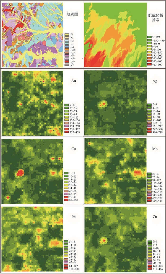
输入数据为1:20万乌兰浩特图幅13个地质、地球物理和地球化学图层,包括地质图、燕山期花岗岩与中—下二叠统接触带缓冲区等值线图、航磁化极异常等值线图、航磁上延5 km等值线图,以及Ag、As、Au、Cu、Hg、Mo、Pb、Sb、Zn地球化学等值线图。在图幅中随机布设846个点,形成训练点图层。图 1显示其中的8个代表性图层。由于在ArcGIS平台上运行空间分析工具要求整型栅格数据,为不降低数据精度,地球3化学图层均乘以100并取整。每个图层网格大小为250 m×250 m,图幅网格总数为57414。
3.2 空间模式识别与矿化模式鉴别
3.2.1 空间模式的地质意义
空间模式是捕捉并集成图幅范围内地质历史演化过程中发生的各种事件留下的地质、地球物理和地球化学印记的空间图形表示。这些印记不是由某个单一的图层而是由全部地质、地球物理和地球化学图层综合表述的。换句话说,每个空间模式都是一组地质、地球物理和地球化学印记的组合,包含了每个输入图层的信息,但又不是原来意义的输入图层信息。
一个空间模式代表图幅区历史上发生过的某个地质事件,但空间模式不是地质事件本身,而是与该事件相关的地质、地球物理和地质化学环境,简称事件环境。本文的研究思路是先找到事件环境,再反推事件本身。如果能有一种方法,能把研究区地质历史上出现过的所有事件环境信息提取出来,那么问题就化为在这些事件环境中是否包含一个或数个矿化事件环境。要做到这一点,首先要保证所获得的空间模式是完备的,是事件环境的全集,没有遗漏。无监督模糊聚类获得的空间模式可以认为是这样一个地质事件环境的全集,条件是它应在图幅精度的意义上满足全集要求。因此,在1:20万比例尺的精度下提取不到的空间模式,有可能在1:5万比例尺的精度下提取到。只要分类器获得的模式满足全集性,图幅具有足够的测量精度,如果图幅内存在矿化,就必然包含在空间模式中。对图幅全部空间模式(事件环境全集)进行鉴别,从中找到与其匹配的空间矿化模式(空间模式的一个子集),就是本文研究图幅矿化问题的基本思路。
3.2.2 空间模式的鉴别标志
将13个地质、地球物理和地球化学图层输入计算机,在GIS平台上运行,获得空间模式后,转入从这些模式中鉴别矿化模式的过程。仅凭感觉很难从中找到矿化模式,为此需要设置一些鉴别准则。大兴安岭中南段已有不少成矿研究成果[19-20], 结合对图幅地质特征、成矿环境和找矿标志的分析,确立以下鉴别准则。
(1) 有利的地层条件:下二叠统大石寨组火山-碎屑岩-大理岩(P1ds),下二叠统神山组碎屑岩-灰岩-安山岩(P1sh),二者之一即可。
(2) 有利的火山岩-次火山岩条件:上侏罗统上兴安岭中酸性火山岩(J3s),上侏罗统中兴安岭火山-凝灰岩(J3z), 上侏罗统大磨拐河碎屑岩(J3d),三者之一即可,与第3条可互补。
(3) 有利的岩浆岩条件:燕山晚期花岗正长岩(γξ53),燕山早期花岗斑岩、斜长花岗斑岩、花岗闪长斑岩(γπ52c),二者之一即可,与第2条可互补。
(4) 有利的地球物理条件:航磁化极处于0~150正异常区间。
(5) 有利的地球化学条件:一种元素具有强异常或2种以上元素具有中等以上异常。
(6) 在空间模式范围内分布有已知矿床。
前5个是必要条件,第6个不是必要条件。对含有已知矿床的图幅,可用于验证结果;对未知地区,只能根据前5条准则进行矿化模式鉴别。
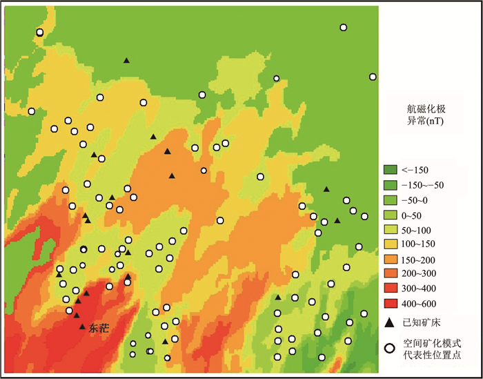
在这里有必要对第4条准则做出说明。在本图幅内,已知矿床和后文鉴别出的所有矿化模式几乎都分布在航磁化极正异常0~150 nT区间内,在正强异常和负异常区间无已知矿床和矿化模式分布。这意味着简单地把这个区间在图上圈定出来,就基本上框定了本图幅的大致矿化分布范围,使用模糊聚类识别出的空间矿化模式则进一步将其细化。这个规律,在乌兰浩特图幅表现得十分明显,在大兴安岭成矿带中段其他图幅是否能复制这个规律,有待考察。图 2显示航磁化极异常与已知矿床和后文鉴别出的空间矿化模式(PAT)的空间分布关系。由图 2可见,已知矿床(黑色三角)和空间矿化模式位置代表点(白色圆圈)基本分布在0~150 nT正异常区间内或紧邻该区间。唯一例外是,在图幅东南角有一个矿床明显落入高正异常的红色区,其名为东茫,是海西晚期铜镍硫化物矿床,不是本文讨论的岩浆热液矿床类型;按其成矿特点,理应具有高磁异常环境。此外,在图幅的东部有少数几个代表矿化模式的点落入负异常区间,原因待查。
3.2.3 空间模式的识别与输出
将上述13个地质、地球物理和地球化学图层输入计算机,在GIS平台上使用SDM空间分析软件中的神经网络工具GeoXplore,经机器学习和回代分类,获得32个空间模式,以PAT1到PAT32编号,然后进入下面的鉴别程序。
3.2.4 空间模式与输入图层的系统聚类分析
为了梳理空间模式之间的关系,寻找矿化模式的空间分布规律,首先对全部空间模式和输入图层进行系统聚类分析,得到2个R型聚类分析结果。对它们进行解读,是鉴别空间矿化模式的第一步。
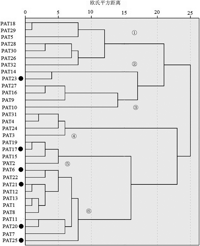
图 3为空间模式系统聚类树枝图。该图是将矿化与非矿化模式混在一起分类,以亲近度15为切割点,得到6个空间模式聚类组。这6个聚类组各具什么意义?为此需要了解PAT系统聚类的原理。每个PAT是一个围绕中心点形成的簇群,树枝图反应各簇群中心点之间的距离关系,本图用的是平方欧式距离,在图幅上表现为空间模式之间在二维平面上的空间亲疏关系。因此2个模式越接近,在图幅上的空间位置就越接近;如2个模式的欧氏距离为零,则两者在空间分布上完全重合。所有的空间模式加在一起,就应该覆盖整个图幅范围。
图 3中6个空间模式聚类组的分布特征如下:第①组主要分布于图幅西南部,个别向西北延伸,未鉴别出矿化模式;第②组分布于西南大部,略呈南西—北东方向延展,鉴别出矿化模式PAT23;第③组主要分布于图幅东北部,个别向南东延伸,未鉴别出矿化模式;第④组主要分布于图幅西北部,个别向南延伸,未鉴别出矿化模式;第⑤组分布于图幅东南部,鉴别出矿化模式PAT17;第⑥组总体呈南西—北东对角线分布,以PAT25为代表,但在偏东处包含一个南东—北西向的小空间模式。鉴别出的其他矿化模式有PAT6、PAT21、PAT20,是本图幅最重要的矿化模式聚类组。
上述6个聚类组反映的实际是13维变量空间投影在二维地理平面上的分布,显示出各种区域化、个性化特征,其中只有部分聚类组包含空间矿化空间模式,呈南西—北东向横贯全区的聚类组⑥拥有最多的矿化空间模式,Mo、Cu、Pb、Zn、Sb、Hg、Au、Ag异常主要沿此带分布,应视为本图幅最主要的找矿方向和找矿范围。
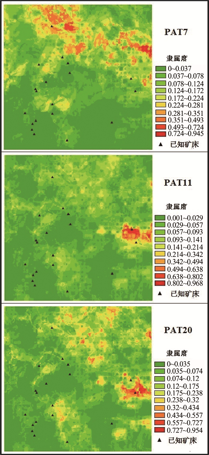
图 4显示第⑥组中的一个南东—北西向小空间模式聚类亚组,是由PAT7、PAT11和PAT20三个空间模式组成(欧氏距离小于7),其中PAT20对观察该聚类亚组的空间分布具有代表性。由图中黄色以上背景可见,三者分布趋势相同。PAT7不满足上述划分矿化模式的条件,被鉴别为非矿化模式;PAT11和PAT20均满足条件,被鉴别为矿化模式,其中PAT20包含PAT11,属于同一矿化模式,只是在PAT11位置处的具体分布细节和强度上有所差异,因此,PAT11在下文不再单独列出。
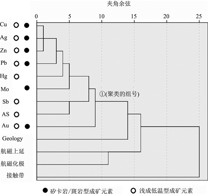
图 5显示输入图层的系统聚类结果,显示出本区独特的成矿元素组合特征。由图 5可见,13个输入图层在亲近度为10的水平上只形成了一个有关联意义的聚类组,以欧氏距离表示。第一组为9个地球化学元素,相互间具有较高的关联性,其中Cu、Ag、Pb、Zn的关联性最高,是本区最主要的成矿元素组合。图 5中黑色实心圆圈代表矽卡岩/斑岩型矿化,空心圆圈代表浅成低温热液型矿化。绝大多数元素既可能参与矽卡岩/斑岩型矿化,也可能参与浅成低温热液型矿化。即使是矽卡岩/斑岩型矿化,也带有低温热液矿化过程。以神山矽卡岩型矿床为例,其具有Fe-Cu-Mo-Pb-Zn-Au-Ag元素组合矿化特点,而在长江中下游,矽卡岩矿床以Fe-Cu-Au元素组合为特点,有IOCG型矿化之说。在矽卡岩、斑岩和浅成低温热液三大矿化类型中,本区浅成低温热液型矿化似乎更具普遍性,它既可能与侵入活动有关,也可能与火山活动有关。单独的浅成低温热液型、矽卡岩-浅成低温热液型、斑岩-浅成低温热液型矿化在本图幅中均有存在的可能。图 5中后面几个地质和地球物理图层相似性程度低,构不成聚类组,只能孤立地与其他聚类组连接,在模式识别中起到独立的而不是相互关联的作用。
3.2.5 空间矿化模式的鉴别结果
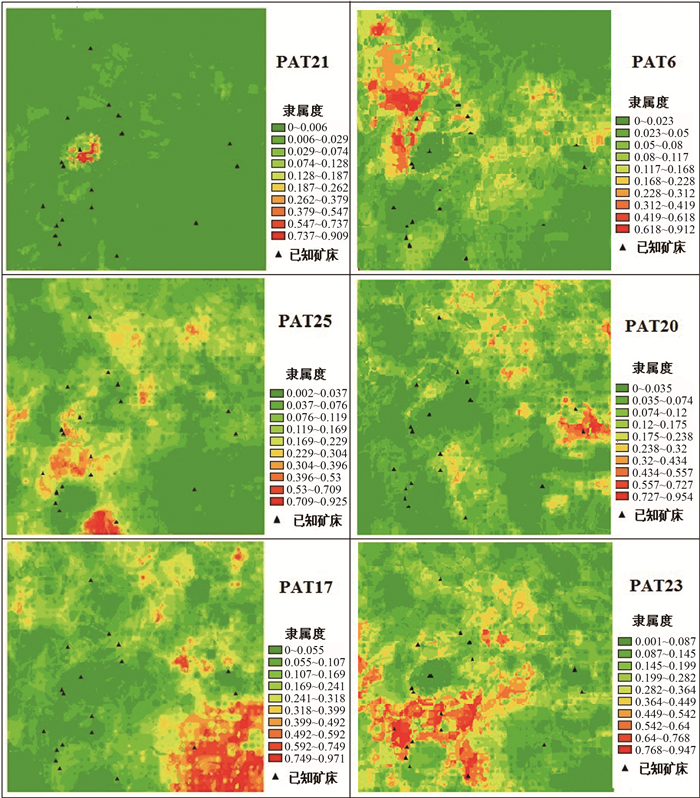
本文以内蒙古乌兰浩特1:20万图幅为例,使用13个地质、地球物理、地球化学图层进行模糊聚类识别出32个空间模式,按3.2.4节的准则进行鉴别后获得6个矿化模式:PAT21、PAT25、PAT17、PAT6、PAT20、PAT23。鉴别出的空间矿化模式图像见图 6,鉴别信息列入表 1。现将每个空间矿化模式的地质特征与找矿意义简述如下。
表 1 空间矿化模式鉴别Table 1. Criteria for spatial mineralization pattern identification空间模式组号 空间模式号 已知典型矿床 空间分布特征 地质特征 地球化学、地球物理特征 目标矿床类型 已知矿床数 6 PAT21 神山金-钼-铅-铁-铜-锌-银矿床 研究区西部,南西—北东方向线上 下二叠统大石寨组火山-碎屑岩-大理岩系(P1ds),下二叠统神山组(P1sh)碎屑岩、灰岩及安山岩,燕山早期花岗斑岩、斜长花岗斑岩、花岗闪长斑岩(γπ52c) 异常:Zn-Mo-Hg-Cu-Ag强,航磁化极异常范围0~+150 矽卡岩型 2 6 PAT25 白音花旗西金-银-铜矿床 斜贯图幅南西—北东向展布 上侏罗统大磨拐河碎屑岩系(J3d),上侏罗统中兴安岭火山-凝灰岩系(J3z),下二叠统神山组(P1sh)碎屑岩、灰岩及安山岩 异常:Zn-Sb-Hg-Au-As强,航磁化极异常范围0~+150 矽卡岩型
斑岩型
浅成低温
热液型7 5 PAT17 宝龙山铜-钼-银矿床 图幅东南端,南西—北东方向展布背景弱 海西晚期花岗岩(γ43-2b),上侏罗统中兴安岭火山-凝灰岩系(J3z) Au- Hg-As强,航磁化极异常范围0~+150 斑岩型
浅成低温
热液型2 6 PAT6 小巴音胡硕金-铜-银矿床 图幅西北部,显示南西—北东方向展布背景 下二叠统大石寨组火山-碎屑岩-大理岩系(P1ds),下二叠统神山组(P1sh)碎屑岩、灰岩及安山岩,燕山晚期花岗正长岩岩组(γξ53)、燕山早期花岗斑岩、斜长花岗斑岩、花岗闪长斑岩(γπ52c) 异常:Mo强,Au零散中等异常,航磁化极异常范围0~+150 矽卡岩型 6 6 PAT20 后六九铜-钼矿床龙江六九铜-银矿床 图幅东部,呈清晰的南西—北东方向展布特征 上侏罗统上兴安岭中酸性火山岩组(J3s),上侏罗统中兴安岭火山-凝灰岩系(J3z),上侏罗统大磨拐河碎屑岩系(J3d),燕山早期花岗斑岩、斜长花岗斑岩、花岗闪长斑岩(γπ52c) 异常:Mo-As强,Sb中—强,Pb中—强,航磁化极异常范围0~+150 斑岩型、浅成低温型 3 2 PAT23 大黑山金-铜-铁矿床 位于中偏西部 上侏罗统大磨拐河碎屑岩系(J3d),上侏罗统上兴安岭中酸性火山岩组(J3s),下二叠统大石寨组火山-碎屑岩-大理岩系(P1ds) 异常:Mo-Pb-As强,航磁化极异常范围0~+150 矽卡岩型、浅成低温型 13 PAT21:属于第⑥组的一个呈独立小范围分布的空间矿化模式。从其背景图像可以隐约地看到南西—北东走向。在这个范围内,分布下二叠统大石寨组火山-碎屑岩-大理岩(P1ds),下二叠统神山组碎屑岩、灰岩及安山岩(P1sh)。燕山早期花岗斑岩、斜长花岗斑岩、花岗闪长斑岩(γπ52c)。Zn-Mo-Hg-Cu-Ag显示强异常。该模式反映出的是以神山矿床为核心、包含其外围的矿化区分布。神山是大兴安岭中南段最重要的矽卡岩型矿床之一,成矿元素组合为Fe-Au-Mo-Pb-Cu,矿体产于晚侏罗世伊力特英云闪长岩与中二叠统哲斯组(P2zs)碳酸盐岩-碎屑岩地层的接触带上。这是一个包含成矿元素最多的强矿化模式,在图幅范围内具有领军意义,无其他模式可比,应在这个矿化模式范围内发现更多更大的矿床。目前被认为属矽卡岩型矿化,但不排除区内有存在斑岩型、浅成低温热液型矿化的可能性。
PAT25:是一个典型的第⑥组沿南西—北东方向展布的空间矿化模式。在这个模式内分布的主要是上侏罗统大磨拐河碎屑岩系(J3d),上侏罗统中兴安岭火山-凝灰岩系(J3z)。图幅内地球化学异常主要沿此矿化模式方向分布。落入此模式的白音花旗西金-银-铜矿床具有典型意义,围绕该矿床Fe-Cu-Pb-Zn-Ag-Sn-Mo矿化普遍, 矿点繁多,是属于矽卡岩型、斑岩型、浅成低温热液型共享的矿化模式。
PAT17:位于图幅东南端,是一个非典型的第⑥组空间矿化模式。初看并不符合第⑥组空间模式沿南西—北东向展布的特征,但细看其西南部仍隐约呈现这个方向的背景,东北部显示出与PAT25相同的矿化方向,但是南部的矿化重点向东位移,成为本模式的主要矿化分布区。模式范围内主要出露海西晚期花岗岩(γ43-2b),上侏罗统中兴安岭火山-凝灰岩系(J3z)小片分布,显示Au- Hg-As强异常。已知有宝龙山铜-钼-银矿床。属斑岩-浅成低温热液型矿化。
PAT6:位于图幅西北部,也是一个第⑥组非典型空间矿化模式。与PAT17互为镜像,一个矿化区在对角线东南角,一个矿化区在对角线西北角,但背景的南西—北东向特征明显。模式范围内主要分布燕山晚期花岗岩(γξ53),下二叠统大石寨组火山-碎屑岩-大理岩系(P1ds),显示Mo强异常,金散布中等异常。落入此空间矿化模式的有小巴音和硕金-铜-银矿床。据鄂阿强等[21]研究,矿床产于上侏罗统次流纹岩体(J3γ)和上侏罗统满头鄂博组(J3mk)接触带,具有次火山热液性质。从燕山晚期花岗岩与中—下二叠统碎屑-碳酸盐岩广泛的接触关系看,本模式应以矽卡岩型矿床化为主,兼有浅成低温热液矿化性质。
PAT20:分布在图幅东部,第⑥组空间矿化模式在这里发生了方向转换,由南西—北东向转变为南东—北西向,这一转换主要出现在图幅东部,西部的南西—北东向矿化方向特征也基本消失。在本矿化模式东南段主要分布上侏罗统上兴安岭中酸性火山岩组(J3s),并有零星燕山早期花岗岩(γπ52c)出露;在其中段,是大片上侏罗统中兴安岭火山-凝灰岩系(J3z)分布区;在其西北段,主要分布上侏罗统大磨拐河碎屑岩系(J3d)。显示Mo-As强异常,Sb中—强异常,Pb中—强异常。本矿化模式代表性矿床有后六九铜钼矿床和龙江六九铜银矿床。前者为斑岩型矿床,产于燕山晚期小侵入体中,赋矿岩石为花岗闪长岩和花岗斑岩[16];后者为浅成低温热液矿床,产于燕山晚期花岗岩侵位下白垩统光华组(K1gn)火山岩形成的引爆角砾岩中,认为具有低温热液成矿性质[17]。基于以上成矿特征,本空间模式属斑岩-浅成低温热液型矿化类型。
PAT23:属于第②组,总体南西—北东走向,但向两侧广泛扩展的空间模式。模式位置偏西南,范围较宽。在此矿化模式内,岩石类型非常复杂,从西到东依次为下二叠统大石寨组火山—碎屑岩—大理岩系(P1ds),下二叠统神山组碎屑岩、灰岩及安山岩(P1sh),上侏罗统大磨拐河碎屑岩系(J3d),未见燕山期花岗岩类分布,显示Mo-Pb-As强异常。该模式包含的已知矿床最多,如大黑山矿床、查干居鲁河金银矿床、胡镇西五棵树铁矿床等。据吴燕平研究[22],大黑山具有2种矿床类型:矽卡岩型和岩浆热液型,成矿与晚侏罗世黑云母花岗闪长岩有关。属矽卡岩-浅成低温热液型矿化模式。
在上述6个空间矿化模式中,PAT21属于勘查成熟区,其范围很小,基本上围绕神山矿床分布,矿产勘查程度和矿床研究程度都很高,是成矿元素多、矿床规模大、最具成矿优势的地区,应继续寻找潜在的矿床,特别是隐伏矿床。PAT23属于半成熟区,面积较大,发现矿床最多,尚有很多无矿床矿点分布的地段,特别是在模式的东部尚未发现矿床,在进一步找矿部署时应予以注意。余下4个矿化模式PAT25、PAT17、PAT16和PAT20属于未成熟区,有成片的区域未发现矿床,是4个应重点部署找矿工作的地区。
对上述6个矿化模式的解读表明,矿床在空间上往往是多种类型混合交错分布的;甚至在同一个矿床中,斑岩型与矽卡岩型、斑岩型与浅成低温热液型、矽卡岩型与浅成低温热液型也会共生在一起。这3种矿化类型,实际上在深部属于同一成矿系统,只是由于在近地表处的围岩和构造条件变化,才形成最终的矿床类型。
各种类型之间显示出明显的牵连性,即一个空间模式可能与另一个空间模式部分重叠。重叠的部分意味着两者存在共性,不重叠的部分意味着两者各具个性。要注意重叠部分不是等同的,在隶属度上应该一个更高,一个更低,只有这样才符合不同空间模式在分类上的竞争性原理。
本次研究不预先指定某个矿床类型为目标,让每个空间网格按其输入的地质、地球物理和地球化学信息按竞争性原则选择空间模式归属,最后应用矿床类型的知识对空间模式进行解读。这种空间矿化模式的识别与鉴别方法,更符合成矿多样性特征和图幅区的矿化实际,也将取得更好的找矿效果。
3.2.6 方法的效果
无监督的神经网络分类方法不预设目标,不是用一个或少数几个有目标的空间模式评价空间矿化,而是用在图幅精度下可能存在的全部空间模式评价空间矿化。成矿具有多样性,相应的空间模式应具有多样性,以多样性对多样性,矿化评价会取得更好的效果。
表 2显示图幅内19个矿床矿点与6个空间矿化模式的配合关系。由表 2可见,用6个空间矿化模式中的任何一个都不能覆盖全部19个矿床矿点,而将6个模式加在一起,则覆盖了18个矿床矿点,相互间没有太大重复,呈互补关系,即这一个空间矿化模式不能覆盖的矿床矿点,被另一个空间矿化模式所覆盖。这意味着矿床类型的空间分布比设想的更复杂,可能有单独的矽卡岩型、斑岩型、浅成低温热液型矿化,也可能有矽卡岩-斑岩型、矽卡岩-浅成低温热液型、斑岩-浅成低温热液型矿化,甚至可能出现2种或更多地质、地球物理或地球化学有差别的矽卡岩型矿化、斑岩型矿化或浅成低温热液型矿化,它们以不同的空间矿化模式表现出来。在研究矿床成因时,建立矿床类型的概念十分必要,可以找出成矿规律的共性因素;但在进行具体的矿化识别时,不必拘泥于某个类型,而应挖掘其自然形成的各种空间矿化模式,这种模式有多少?是哪些地质、地球物理、地球化学特征的组合,事先是不知道的,只有由其自身来回答。模糊聚类是获得这种回答的工具,由地质学家鉴别出的空间矿化模式就是对问题的最终解读。
表 2 空间矿化模式包含的已知矿床统计Table 2. Statistical information of known deposits included in spatial mineralization patterns矿床 PAT21 PAT25 PAT17 PAT6 PAT20 PAT23 胡镇西五棵树 * * 小巴音胡硕 * / 扎兰屯西 * / / 神山 * * 扎兰屯北 / * * 白音苏木 * / 乌兰毛苏木 * / 育林 * / / 林业队 * * 大黑山 * * 居鲁河 * 查干居鲁河1 * 查干居鲁河2 * 东茫 白音花旗西 * * * 宝龙山 * 龙江六九 / * 后六九 * 哈拉 * * 注:*表示矿床矿点在矿化模式核心区,/表示在边缘 表 2中唯一1个未被6个矿化模式覆盖的,是位于图幅西南角的东茫矿床(图 2),这是一个海西晚期的铜镍硫化物矿床,不属于本文岩浆热液矿床研究的范围,不予讨论。
4. 结论
(1) 模糊聚类是一种基于神经网络的无监督分类器,在GIS平台上运行,具有强大的空间数据挖掘能力。本文将其用于空间矿化模式识别,构建了基于地物化输入图层,挖掘全部可能存在的空间模式、并从中鉴别出空间矿化模式的工作流程。通过模糊聚类,获得32个空间模式,结合成矿带特征、矿床类型和成矿地质条件分析,从中鉴别出6个空间矿化模式。
(2) 图幅范围内的已知矿床矿点验证结果表明,6个空间矿化模式完全覆盖了这些矿床矿点,且各空间矿化模式显示出对已知矿床覆盖的互补性与牵连性。互补性表明成矿过程的个性特征,牵连型表明成矿过程的共性关联。在矿化评价中,既要重视共性,更要重视个性。
(3) 本图幅属于大兴安岭成矿带中段,以矽卡岩型、斑岩型和浅成低温热液型矿化为主。对矿化模式的分析表明,在图幅范围内显示3种矿化类型,但彼此之间并不是截然分离而是交错重叠的,显示出成矿的多样性。6个空间矿化模式对成矿的多样性做出了响应。系统聚类分析显示的成矿元素组合特征表明,浅成低温热液矿化在本区具有显著的找矿潜力,它可能渗透到矽卡岩型或斑岩型矿化过程中,形成各种综合类型低温热液矿床。
(4) 模糊聚类方法是不预设目标矿床类型的无监督分类,其预测结果更具客观性,更符合图幅区矿化的实际分布情形。对机器识别出的空间模式,地质学家可根据自己的知识和经验,进行多样化的解读。
致谢: 感谢Rains G博士对笔者使用SDM空间分析系统提供的深入细致帮助。中国地质调查局自然资源航空物探遥感中心熊盛青总工程师为本文开展的工作图幅航磁数据进行了专门处理,成为识别与鉴别空间矿化模式的重要依据,在此深表谢意。 -
表 1 空间矿化模式鉴别
Table 1 Criteria for spatial mineralization pattern identification
空间模式组号 空间模式号 已知典型矿床 空间分布特征 地质特征 地球化学、地球物理特征 目标矿床类型 已知矿床数 6 PAT21 神山金-钼-铅-铁-铜-锌-银矿床 研究区西部,南西—北东方向线上 下二叠统大石寨组火山-碎屑岩-大理岩系(P1ds),下二叠统神山组(P1sh)碎屑岩、灰岩及安山岩,燕山早期花岗斑岩、斜长花岗斑岩、花岗闪长斑岩(γπ52c) 异常:Zn-Mo-Hg-Cu-Ag强,航磁化极异常范围0~+150 矽卡岩型 2 6 PAT25 白音花旗西金-银-铜矿床 斜贯图幅南西—北东向展布 上侏罗统大磨拐河碎屑岩系(J3d),上侏罗统中兴安岭火山-凝灰岩系(J3z),下二叠统神山组(P1sh)碎屑岩、灰岩及安山岩 异常:Zn-Sb-Hg-Au-As强,航磁化极异常范围0~+150 矽卡岩型
斑岩型
浅成低温
热液型7 5 PAT17 宝龙山铜-钼-银矿床 图幅东南端,南西—北东方向展布背景弱 海西晚期花岗岩(γ43-2b),上侏罗统中兴安岭火山-凝灰岩系(J3z) Au- Hg-As强,航磁化极异常范围0~+150 斑岩型
浅成低温
热液型2 6 PAT6 小巴音胡硕金-铜-银矿床 图幅西北部,显示南西—北东方向展布背景 下二叠统大石寨组火山-碎屑岩-大理岩系(P1ds),下二叠统神山组(P1sh)碎屑岩、灰岩及安山岩,燕山晚期花岗正长岩岩组(γξ53)、燕山早期花岗斑岩、斜长花岗斑岩、花岗闪长斑岩(γπ52c) 异常:Mo强,Au零散中等异常,航磁化极异常范围0~+150 矽卡岩型 6 6 PAT20 后六九铜-钼矿床龙江六九铜-银矿床 图幅东部,呈清晰的南西—北东方向展布特征 上侏罗统上兴安岭中酸性火山岩组(J3s),上侏罗统中兴安岭火山-凝灰岩系(J3z),上侏罗统大磨拐河碎屑岩系(J3d),燕山早期花岗斑岩、斜长花岗斑岩、花岗闪长斑岩(γπ52c) 异常:Mo-As强,Sb中—强,Pb中—强,航磁化极异常范围0~+150 斑岩型、浅成低温型 3 2 PAT23 大黑山金-铜-铁矿床 位于中偏西部 上侏罗统大磨拐河碎屑岩系(J3d),上侏罗统上兴安岭中酸性火山岩组(J3s),下二叠统大石寨组火山-碎屑岩-大理岩系(P1ds) 异常:Mo-Pb-As强,航磁化极异常范围0~+150 矽卡岩型、浅成低温型 13 表 2 空间矿化模式包含的已知矿床统计
Table 2 Statistical information of known deposits included in spatial mineralization patterns
矿床 PAT21 PAT25 PAT17 PAT6 PAT20 PAT23 胡镇西五棵树 * * 小巴音胡硕 * / 扎兰屯西 * / / 神山 * * 扎兰屯北 / * * 白音苏木 * / 乌兰毛苏木 * / 育林 * / / 林业队 * * 大黑山 * * 居鲁河 * 查干居鲁河1 * 查干居鲁河2 * 东茫 白音花旗西 * * * 宝龙山 * 龙江六九 / * 后六九 * 哈拉 * * 注:*表示矿床矿点在矿化模式核心区,/表示在边缘 -
Alliams M. Method of appraising economic prospects of mining exploration over large territories - Algerian Sahara case study[J]. Management Sci., 1957, 3(4): 285-345.
Agterberg F P, Davi S R. A statistical method for the distribution of copper, lead and zinc in the Canadian Appalachian region[J]. Eco. Geol., 1978, 73(2): 230-245. doi: 10.2113/gsecongeo.73.2.230
Harris D P. Mineral resourcesappraisal - mineral endowment, resource, and potential supply: concepts, methods, and cases[M]. Oxford University Press, 1984: 1-464.
赵鹏大, 胡旺亮, 李紫金. 矿床统计预测[M]. 北京: 地质出版社, 1994: 1-314. Bonham-Carter G, Agterberg F P, Wright D F. Weights of evidence modeling: a new approach to mapping mineral potential[C]//Statistical Applications in the Earth Sciences, Canadian Government Publishing Centre, Ottawa, 1989: 171-183.
Rains G, Bonham-Carter G. Introduction to special issue to on spatial modeling in GIS[J]. Natural Resources Research, 2007, 16(2): 81-84. doi: 10.1007/s11053-007-9041-x
Korytkowski M, Scherer R, Tadeusiewicz R, et al. Artificial Intelligence and Soft Computing[C]//Proceedings, Part Ⅱ, 15th International Conference. ICAISC, Poland, 2016.
Paris J, Vencovska A. Principles of uncertain reasoning[C]//Philosophy and Cognitive Categories, Consciousness, and Reasonong. Springer, 1996: 221-259.
李裕伟, 赵金满, 李晨阳. 基于GMS、DSS和GIS的潜在矿产资源评价方法[M]. 北京: 地震出版社, 2007: 1-946. 张尧庭, 杜劲松. 人工智能中的概率统计方法[M]. 北京: 科学出版社, 1998. Looney C G. Interactive clustering and merging with a new fuzzy expected value[J]. Pattern Cognition, 2002, 35(11): 2413-2423. doi: 10.1016/S0031-3203(01)00213-8
Raines G, Bonhan-Carter G. Introduction to special issue on spatial modeling in GIS[J]. Natural Resources Research, 2007, 16(2): 81-84. doi: 10.1007/s11053-007-9041-x
Xie X L, Beli G. A validity measure for fuzzy clustering[J]. IEEE Trans. Pattern Analysis and Machine Intelligence, 1991, 13(8): 841-847. doi: 10.1109/34.85677
Looney C G. Fuzzy connectivity clustering with radial basis kernel functions[J]. Fuzzy Sets and Systems, 2009, 160(13): 1868-1885. doi: 10.1016/j.fss.2008.12.010
马骏超, 刘桂香, 张德宝, 等. 内蒙古扎赉特旗神山铁铜矿床地质特征及找矿标志[J]. 地质与资源, 2018, (3): 225-256. https://www.cnki.com.cn/Article/CJFDTOTAL-GJSD201803006.htm 李德胜. 黑龙江省龙江县后六九铜钼矿床地质特征及成因初探[J]. 矿产与地质, 2003, 17(97): 354-357. https://www.cnki.com.cn/Article/CJFDTOTAL-KCYD2003S1026.htm 梁培基. 黑龙江省龙江县六九山铜银矿矿床地质特征及找矿标志[D]. 石家庄经济学院硕士学位论文, 2015: 1-240. 古阿雷, 孙景贵, 白令安, 等. 大兴安岭中段闹牛山浅成热液多金属矿床流体包裹体研究[J]. 矿物岩石, 2018, 38(153): 28-39. https://www.cnki.com.cn/Article/CJFDTOTAL-KWYS201803005.htm 金若时, 刘永顺, 张跃龙, 等. 大兴安岭中南段昌图锡力锰、银、铅、锌多金属矿床的发现及其意义[J]. 地质通报, 2017, (7): 1268-1275. doi: 10.3969/j.issn.1671-2552.2017.07.016 马一行, 吕志成, 颜廷杰, 等. 内蒙古昌图锡力地区重磁场特征与深部找矿指示[J]. 地质通报, 2020, 39(8): 1258-1266. http://dzhtb.cgs.cn/gbc/ch/reader/view_abstract.aspx?file_no=20200813&flag=1 鄂阿强, 杜青松. 大兴安岭地区小巴音胡硕铜多金属矿床地质特征[J]. 内蒙古科教经济, 2016, (20): 62-64. https://www.cnki.com.cn/Article/CJFDTOTAL-NMKJ201620030.htm 吴燕平. 内蒙古扎赉特旗大黑山区金铜铁矿矿床特征及找矿远景[D]. 吉林大学硕士学位论文, 2013: 1-62. -
期刊类型引用(6)
1. 吴净,郭佳怡,张明礼,王延华. 湖泊氮沉积研究热点与发展趋势. 南京师大学报(自然科学版). 2025(01): 18-27 .  百度学术
百度学术
2. 刘欣月,李海波,刘胜山,何文杰,董浩,程艳,乔俊豪,徐银. 大冶湖沉积物氮磷形态分布特征及生态风险评价. 环境科学学报. 2024(06): 161-173 .  百度学术
百度学术
3. Bo Han,Zhen Ma,Liang-jun Lin,Hong-wei Liu,Yi-hang Gao,Yu-bo Xia,Hai-tao Li,Xu Guo,Feng Ma,Yu-shan Wang,Ya-long Zhou,Hong-qiang Li. Planning and construction of Xiong'an New Area(city of over 5 million people):Contributions of China's geologists and urban geology. China Geology. 2024(03): 382-408 .  必应学术
必应学术
4. 杨关绍,温雯雯,王旭,郭雯,王明果,黄林培,孔令阳,李蕊,陈光杰,王教元. 异龙湖草——藻型稳态转换的碳氮磷化学计量特征及埋藏量估算. 地理学报. 2024(11): 2830-2848 .  百度学术
百度学术
5. 雷晓玲,韩程远,魏泽军,杨程,李璐. 多级雨水塘径流污染特征及底泥氮、磷污染风险评价研究. 环境科学与管理. 2023(06): 173-178 .  百度学术
百度学术
6. 邱坚,原璐彬,邢书语,刘鑫,丁益华,田苗苗. 镇江市金山湖沉积物磷元素分布特征研究. 环境监控与预警. 2023(06): 85-92 .  百度学术
百度学术
其他类型引用(4)


 下载:
下载:
