Late Pliocene oblique thrusting and regional stress field changes in southern Longmen Mountain, eastern Tibet
-
摘要:
2008年汶川地震(Mw 7.9)同震滑移结果表明,今地壳缩短为近EW向,与龙门山褶皱冲断带斜交。这一斜向逆冲作用的准确起始时间一直未得到很好的约束。基于龙门山南段山前大邑背斜区三维地震解释和构造建模,结合野外地质调查和年代学数据,确定了晚新生代存在NE向和近NS向2期构造变形。120km长的NS向构造切割了NE向构造,表明近NS向构造形成时间较晚。山前大邑和邛西背斜区近NS向断层和褶皱的活动,均反映了龙门山南段局部或区域上水平最大主应力方向的转换过程,渐新世-早上新世的NW-SE向转变为晚上新世-全新世的近EW向。龙门山南段山前发育的NS向构造和汶川地震同震变形均反映出青藏高原东缘最新的EW向地壳缩短过程,为理解青藏高原东缘的隆升机制提供了新的视角。
Abstract:The co-seismic slip sense of the 2008 Wenchuan earthquake (Mw 7.9) has demonstrated the present east-west (E-W) crustal shortening and oblique thrusting across the Longmen Mountain. However, the oblique thrusting and its initial time remain poorly investigated. By using 3-D seismic reflection data, field investigation, and published dating results, the authors investigated the E-W crustal shortening in the Dayi Fault System (DYFS), and determined tectonic stress field changes during the Late Cenozoic. Two-period tectonic deformations were found in the DYFS, which correspond to the NE-and NS-trending structures, respectively. The activities of the DYFS and Qiongxi Fault System reflect a change in the direction of the tectonic stress, from NW-SE during the Oligocene and Early Pliocene to E-W from the Late Pliocene to Holocene. The 120km NS-trending structures in the southern Longmen Mountain range front as well as the Wenchuan earthquake co-seismic ruptures are assumed to reflect the active, E-W crustal shortening in Longmen Mountain, eastern Tibet plateau. The results obtained by the authors provide a new perspective for the uplift mechanisms of eastern margin of the Tibetan Plateau.
-
斜向俯冲(逆冲)作用,指汇聚-俯冲或者碰撞方向与大型断裂带走向不垂直(即存在走滑分量)的逆冲作用,在板块俯冲带和褶皱冲断带普遍存在。典型的斜向俯冲带有Sumatra[1],Nankai[2-3],Chilean[4]等;典型的斜向褶皱冲断带有Himalaya[5-6],Alps[7-8],Taiwan[9-10],Andes[11-12],Zagros[13-14]等。这些地区既是近10a来大地震频发区[3, 5, 10, 15-17],也是研究板块构造理论的天然实验室。此外,研究斜向逆冲作用可为能源勘探[18]、矿产资源开发[19]、地震危险性评估[15]、地貌演化[19]等提供科学依据。
龙门山属于非典型性的褶皱冲断带,具有独特的地形地貌和构造特征,主要包括:①陡降地形,作为环青藏高原周缘最陡峭的地形地貌边界,部分地方可以在50km的范围内由5000m降至500m[20];②陡变地壳厚度,从青藏高原腹地的60~70km降至四川盆地的40~50km[21];③低水平缩短速率,汶川地震之前的GPS测量数据表明水平缩短速率小于3mm/a[22];④山前川西盆地缺乏连续完整的新生代沉积记录, 这似乎暗示该地区缺乏新生代以来的前渊凹陷和构造挠曲变形[20, 23-25]。
龙门山地区年轻的高地形和低水平缩短速率、缺乏前渊凹陷之间形成强烈对比,这一特征直接启发了下地壳流动模式,Royden等[26]认为,下地壳物质从高原内部向东流动过程中受到四川盆地坚硬克拉通的阻挡而产生侧向支撑作用,使龙门山能够在没有大规模逆冲推覆和挠曲沉降的情况下快速隆升,这种地壳增厚主要发生在下地壳,而上地壳很少或没有明显的缩短变形。该模式虽然可以很好地解释龙门山边界存在的上述4个非同寻常的特征[26-28],但造成了超过8万人死亡和近10亿元的经济损失的2008年汶川地震,以极端震撼的方式展示了龙门山内部强烈的变形作用和正在进行的青藏高原隆升过程[29-31]。汶川地震所体现的上地壳缩短作用不容忽视,因此对流行的下地壳流动模式提出了严峻的挑战,同时也提醒人们需重新审视该理论和其他支撑的证据是否存在更合理的解释[29]。汶川地震的发生,再一次引发了青藏高原东缘的隆升机制究竟是下地壳流动还是上地壳脆性缩短变形的争论[26, 28-30, 32-35]。
争论的焦点在于晚新生代龙门山地壳缩短变形模式。中生代以来龙门山主要经历了晚三叠世和新生代2期重要的地壳缩短变形[20, 23-24]。晚三叠世龙门山在调节SE向逆冲挤压作用下形成NE向延伸的龙门山褶皱冲断带和川西前陆盆地,表明早期造山作用为NW-SE向[20, 24]。晚新生代印度-欧亚大陆碰撞的远距离效应使得龙门山褶皱冲断带被重新激活[20, 24]。但是,对于这一阶段青藏高原东缘的挤压方向存在分歧:一些学者认为晚新生代造山作用方向与晚三叠世一致[36-37];另一种观点则指出晚新生代构造变形可能包含重要的右旋走滑分量[20, 30],后者与汶川地震同震滑移指示的动向一致[30-31, 38-39](图 1)。但这一斜向逆冲作用的活动时间、运动学和动力学机制缺乏准确的约束。
![]() 图 1 青藏高原东缘主要活动断层和大地震分布a-青藏高原东缘周缘GPS位移场(据参考文献[22]修改);b-青藏高原东缘龙门山褶皱冲断带和四川盆地西部区域构造位置,2008年汶川地震震中位置和震源机制解,同震地表破裂和未破裂的主断层[30, 38-39], 1970年大邑地震、1976年松潘地震和2013年芦山地震震源机制解[34, 42-43]和区域地震剖面位置均在图中标明(最大水平主应力数据修改据参考文献[39, 44]);c-小鱼洞断层地表破裂和同震滑移场(数据修改据参考文献[45-46])。WMF-汶川-茂汶断裂;YBF-映秀-北川断裂;PGF-彭县-灌县断裂;QCF-青川断裂;MJF-岷江断裂;HYF-虎牙断裂;LRBF-龙日坝断裂;WLF-武龙断裂;BXF-宝兴断裂;DYF-大邑断层;QXF-邛西断层;PLF-平罗坝断层;LQF-龙泉断层;XPF-熊坡断层Figure 1. Main active faults and earthquake events on the eastern margin of the Tibetan Plateau
图 1 青藏高原东缘主要活动断层和大地震分布a-青藏高原东缘周缘GPS位移场(据参考文献[22]修改);b-青藏高原东缘龙门山褶皱冲断带和四川盆地西部区域构造位置,2008年汶川地震震中位置和震源机制解,同震地表破裂和未破裂的主断层[30, 38-39], 1970年大邑地震、1976年松潘地震和2013年芦山地震震源机制解[34, 42-43]和区域地震剖面位置均在图中标明(最大水平主应力数据修改据参考文献[39, 44]);c-小鱼洞断层地表破裂和同震滑移场(数据修改据参考文献[45-46])。WMF-汶川-茂汶断裂;YBF-映秀-北川断裂;PGF-彭县-灌县断裂;QCF-青川断裂;MJF-岷江断裂;HYF-虎牙断裂;LRBF-龙日坝断裂;WLF-武龙断裂;BXF-宝兴断裂;DYF-大邑断层;QXF-邛西断层;PLF-平罗坝断层;LQF-龙泉断层;XPF-熊坡断层Figure 1. Main active faults and earthquake events on the eastern margin of the Tibetan Plateau本次研究基于龙门山南段山前大邑背斜区三维地震数据,通过野外地质实测和地震解释结果,分析地下和地表构造变形走向上的差异性;结合地震相干分析建立三维构造模型,明确2期构造的三维特征及其切割关系;结合背斜区已发表的浅层地震剖面揭示的生长地层记录和大邑砾岩沉积年龄限定,确定出东西斜向逆冲作用的准确时间,并进一步探讨区域构造应力场转换时序及其运动学和动力学机制。
1. 地质背景
龙门山褶皱冲断带位于青藏高原东缘与四川盆地之间,南起雅安北至广元,长约500km,宽30~50km,呈NE向延伸,北东端与秦岭断裂带斜交,南西端被鲜水河断裂斜截。该褶皱带由4个叠瓦状逆冲推覆系统构成,自西向东分别为后山断裂(汶川-茂汶断裂)、中央断裂(映秀-北川断裂)、山前断裂(彭县-灌县断裂)及山前隐伏断裂[23-24, 40-41](图 1)。
龙门山褶皱冲断带在地形地貌、构造变形、构造演化、前陆盆地发育、构造活动性等方面沿走向的差异一直被众多学者所关注。Jia等[24, 47]根据前陆盆地地层发育和构造形态特征,以安县为界将龙门山褶皱冲断带分为南、北2段,北段类似于阿尔卑斯和喀尔巴契的逆冲推覆构造带[20],其中晚三叠世变形强于新生代,南段以基底卷入的叠瓦状冲断为特点,新生代变形尤为突出;Li等[48]通过对比龙门山褶皱冲断带沿走向变形、汶川地震同震破裂和同震断裂的三维构造建模等方面的差异,同样以安县为界将龙门山褶皱冲断带分为南、北2段,北段为以右旋斜向逆冲为主的单条断层且不能向下延伸至主滑脱面,而南段则是以逆冲为主的2条断层,大约在10km深处汇成一条断层向下延伸至主滑脱面。Jin等[49]结合地形地貌、野外调查和地震剖面解释结果等差异性,以安县和都江堰为界将龙门山褶皱冲断带分为分为南、中和北3段(图 1)。本次研究集中于都江堰以南的龙门山南段。
龙门山南段山前不仅发育一系列突破至近地表的NE向构造,如大邑、平罗、熊坡和龙泉山构造[29, 47-48, 50-51],还发育NS向隐伏构造,如邛西和大塘构造[52](图 1)。其中, 大邑构造位于雾中山推覆构造带前缘,地表出露白垩系红层和晚新生代砾石层,呈宽缓的NE向背斜形态(图 2),Densmore等[53]结合野外调查和遥感影像解译证实,该构造第四纪以来存在活动,且1970年大邑地震(Ms 6.2)发生于此构造上[54](图 2)。
2. 大邑背斜构造解释
2.1 野外调查和卫星影像解译
川西盆地广泛缺失晚新生代的沉积地层, 仅有零星的大邑砾岩、雅安砾岩和上更新统局部出露。在四川盆地内部,大量的沉积岩被大面积剥蚀,形成角度不整合面[20, 55]。在这些不整合面之上,几十至几百米厚的以碎屑支撑的砾岩保留在龙门山山前地区[53]。李勇等[25]等利用电子自旋共振对大邑砾岩和雅安砾岩进行了定年,将大邑砾岩和雅安砾石的年龄分别限定为3.6~0.8Ma(上新世-早更新世)和0.6~0.2Ma(中更新世)[25, 53, 56-57]。Kong等[58]利用宇宙成因核素10Be和26Al得到大邑砾岩的埋藏年龄为2.2±0.7Ma、2.1±1.4Ma和2.7±1.2Ma,这一沉积年龄与李勇等[25]的结果一致。大邑砾岩的典型地层剖面位于岷江西岸的大邑氮肥厂附近,该剖面也是大邑砾岩的命名地。大邑构造研究区内广泛出露大邑砾岩,这为大邑构造晚新生代构造变形提供了充分的依据(图 2)。
野外调查表明,大邑县城北剖面中大邑砾岩(产状135°∠51°)与下伏白垩系灌口组红层(146° ∠55°)呈微角度不整合接触(图 3-a~d);崇州河家山剖面中大邑砾岩(155°∠36°)与下伏灌口组(153° ∠42°)也呈微角度不整合接触(图 3-e)。其他大邑砾岩剖面,如灌县玉堂场汤家沟、崇庆街子场、白塔湖、大邑陈家场白岩沟、团结乡、邛崃水口场及名山万古乡庙坡剖面,均显示与下伏地层呈角度不整合接触,少量呈平行不整合接触。大邑背斜区大邑砾岩也发生褶皱变形,结合野外地质填图、3D扫描仪、全站仪测量等技术手段,发现这一区域的大邑砾岩及其下伏地层的褶皱变形时间应为上新世-早更新世,而最新的活动时间应为中更新世-全新世[25, 53, 59-60]。
2.2 大邑背斜地震解释
本次选取了6条过大邑背斜区的石油地震剖面A~F,分别经叠后偏移处理和深度转换,揭示其地下构造几何学特征。其中,地层主要依据钻井资料约束的地层标定,而近地表地层由地质图约束(图 2)。地震剖面中断层和褶皱以断面反射、断层切割、褶皱翼或膝折端终止和倾角域特征来识别(图 4-图 9)。
![]() 图 4 过崇州构造北翼的地震剖面A解释方案(剖面位置见图 2)Pre-P-前二叠系;P-二叠系;T1j-下三叠统嘉陵江组;T2l-中三叠统雷口坡组;T3m-上三叠统马鞍塘组;T3x-上三叠统须家河组;J1-下侏罗统;J2-上侏罗统;K-白垩系;E-古近系;N2-Q1-大邑砾岩;Q-第四系Figure 4. Interpreted seismic profile A across the Chongzhou structure
图 4 过崇州构造北翼的地震剖面A解释方案(剖面位置见图 2)Pre-P-前二叠系;P-二叠系;T1j-下三叠统嘉陵江组;T2l-中三叠统雷口坡组;T3m-上三叠统马鞍塘组;T3x-上三叠统须家河组;J1-下侏罗统;J2-上侏罗统;K-白垩系;E-古近系;N2-Q1-大邑砾岩;Q-第四系Figure 4. Interpreted seismic profile A across the Chongzhou structure![]() 图 9 沿走向地震剖面F,展示滑脱层厚度在走向上的变化和F5断层的侧断坡(剖面位置见图 2)Figure 9. Along-strike NE-trending seismic profile F across the Dayiand Chongzhou structures, showing the along-strike changes of the thickness and lateral ramp of F5 fault
图 9 沿走向地震剖面F,展示滑脱层厚度在走向上的变化和F5断层的侧断坡(剖面位置见图 2)Figure 9. Along-strike NE-trending seismic profile F across the Dayiand Chongzhou structures, showing the along-strike changes of the thickness and lateral ramp of F5 fault根据地震反射剖面A和B、石油钻井数据及地表地质特征,发现大邑背斜北部的崇州构造主要受东倾F4逆冲断层控制。由F4断层控制的上伏背斜主要呈典型的断层相关褶皱特征:背斜前翼短而陡、后翼长而缓;背斜后翼地层与下伏断坡不平行;后翼地层倾角较断坡角(F4)小。根据这些典型的特征,推测崇州构造存在纯剪变形作用[61-62]。考虑断层倾角(θ≈59°~64°)和后翼地层倾角(δb≈9°~22°),解释这一构造为典型的纯剪断层转折褶皱[61-62],大量滑移量自浅部滑脱层传递至断层上,塑性滑脱层系(下三叠统嘉陵江组)吸收和调节少量的构造缩短(图 4、图 5)。实际上,这一构造比纯剪断层相关褶皱端元模型复杂,深部构造对这一构造进行了改造。地震反射剖面A和B中,崇州构造东翼被一东倾的前冲断层切割,这一断层的形成跟剪切作用的调节和褶皱生长中层面偏移的后翼弯曲有关。从地震剖面A可以看出,F5断层切割了崇州构造后翼的大邑砾岩,暗示这一断层形成于大邑砾岩(N2-Q1)沉积之后,而崇州构造的形成时间可能对应大邑砾岩的沉积时间(图 4、图 5)。
结合地震反射剖面C、D和E,以及石油钻井数据和地表地质特征对比发现,位于大邑背斜区南部的大邑构造呈复杂的构造几何学特征。大邑构造主要受深部F1断层控制,浅部F2和F3断层对这一构造进行改造,深浅构造由浅部的下三叠统嘉陵江组塑性膏岩层相连;断层倾角(θ≈26°~48°)大于后翼地层倾角(δb≈10°~24°),由于深部断层F1浅部缓的断坡使得断层滑移量沿断层向浅部减少;大邑构造被下三叠统嘉陵江组发育的西倾的F2断层和东倾的F3断层切割,这2条断层的形成与剪切作用的调节和褶皱生长过程中层面偏移的后翼弯曲有关,同时这些断层将大量的位移量自滑脱层传播至近地表(图 6-图 9)。
2.3 大邑背斜变形样式和机制走向差异性
褶皱冲断带变形样式和变形机制沿走向存在差异性[63],大邑背斜同样存在这些特征。大邑背斜深部,奥陶系和志留系主要由页岩、砂岩和碳酸盐岩组成,而300~900m厚的页岩可能由于其埋藏较深,经历了高温高压而成为这一区域的中部滑脱层系;浅部早三叠统嘉陵江组由碳酸盐岩、砂岩和蒸发岩组成,400~1100m厚的蒸发岩成为这一区域的浅部滑脱层系。沿走向地震剖面F(图 9)和垂直走向地震剖面A~E(图 4-图 8)均揭示浅部滑脱层由南向北逐渐加厚。为了讨论大邑背斜变形样式和变形机制沿走向的差异性,本文基于地震反射剖面建立了3个以断层相关褶皱理论为基础的构造几何学和运动学模型,包括一个单层滑脱层模型和2个底部滑脱层厚度有差异的双层滑脱层模型,以此讨论滑脱层的存在与否及其厚度变化对构造变形样式的影响(图 10)。对比单层滑脱层和双层滑脱层模型,发现浅部滑脱层存在与否对构造几何学和构造运动学特征有重要影响(图 10),而浅部滑脱层对构造变形作用的影响在物理模拟[63-64]和数值模拟[65]中均有讨论,在此不做深入探讨。
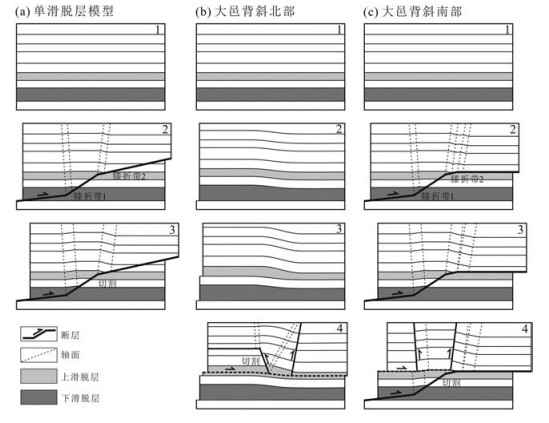
结合典型的构造特征,本文建立了以双滑脱层为基础的概念模型,以塑性变形为主的代表大邑背斜北部的崇州构造(图 10-b),以脆性变形为主的代表大邑背斜南部的大邑构造(图 10-c)。图 10-b中1展示崇州构造北部变形前的几何学特征,在变形的第一阶段,构造缩短被中间滑脱层的滑脱褶皱变形样式的加厚形式所吸收(图 10-b中2);连续的变形导致浅部滑脱层系内的塑性流体向着背斜核部流动而使之上的沉积岩产生不对称的弯曲(图 10-b中3);最后,背斜前后翼发育断层切割能干层,向后的逆冲断层发育在后翼,而向前的逆冲断层发育在前翼,这些构造均连接至浅部滑脱层且改造了深部的剪切断层转折褶皱(图 10-b中4)。对比大邑构造地震剖面,深部断层F1由2个典型的膝折带组成,由此建立由向斜型膝折带和背斜型膝折带组成的深部断层(图 10-c)。图 10-c中1展示变形前的构造几何学特征;在变形的第一阶段,构造缩短被以断层转折褶皱变形样式的断层上盘褶皱形成所吸收,致使构造隆升,由断层作用形成的轴面控制上覆与其平行的地层倾角[62, 66](图 10-c中2);连续的断层滑移使得背斜膝折带进一步加宽,致使构造进一步隆升(图 10-c中3);最后,背斜前后翼均发育断层切割能干层,这些构造均连接至浅部滑脱层且改造了深部的剪切断层转折褶皱(图 10-b中4)。
3. 大邑背斜三维构造特征
3.1 基于三维地震相干刻画断层几何学特征
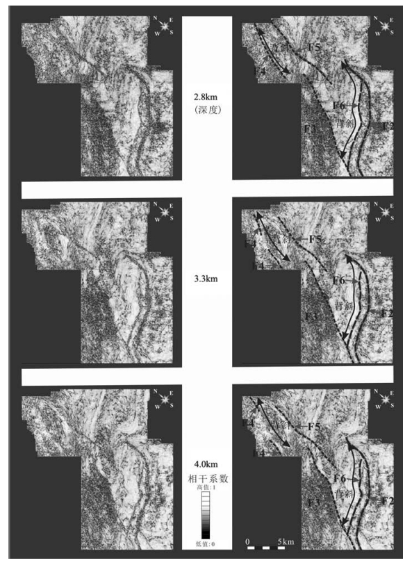
Bahorich等[67-68]最早通过三维地震反射数据提取的地震相干切片属性来刻画断层构造几何学特征和地震道之间的不连续现象,如河道沉积、不整合等。地震相干技术是1995年第65届SEG年会上推出的一种解释性处理技术,可以分辨三维地震数据体中细微断层或其他(地震)道-道之间的不连续[67],其出现被视为三维地震领域里的革命。通过计算在主测线和联络测线中局部波形的相似性,可以获得三维地震相干体[67],从而可在相干切片上很清楚地识别出断层、不同的岩性体系特征。本研究利用Landmark软件中SeisWorks三维模块来制作大邑背斜三维地震数据相干体,消除人为因素定义的大邑背斜地下断层几何学特征,包含0~1数值范围的数据体,其中0代表相邻地震道之间低相干性和低相似性,一般代表断层位置;而1代表相邻地震道之间的高相干性,两侧无差别。为了探讨大邑背斜浅部断层间的相互关系,制作了0~6km深的三维地震相干数据体,考虑到浅部断层出露深度情况,选取了3个不同深度的相干切片,分别为2.8km、3.3km、4.0km深(图 11)。根据地震相干切片中相干性的大小,提取出大邑背斜区主要的断层F2~F6,这些低相干性、低相似性的位置(断层)(图 11)和地震反射剖面中解释的断层位置一致(图 4-图 9),很好地验证了前文中的构造解释方案。地震相干切片清晰地展示了存在2组不同走向的断层,NNE向和NE走向,东倾的逆冲断层F2和F6为NE走向(N47°E-N70°E),西倾的逆冲断层F3和F4为NNE走向(N15°E-N25°E),东倾的逆冲断层F5为NNE走向(N9° E-N13° E)(图 11)。NNE走向断层F3切割了NE走向断层F6和北西侧的背斜,暗示2组走向断层形成时间上存在先后关系,NNE走向断层F3~F5发育时间晚于NE走向断层F2和F6(图 11)。
3.2 三维构造建模刻画断层几何学特征
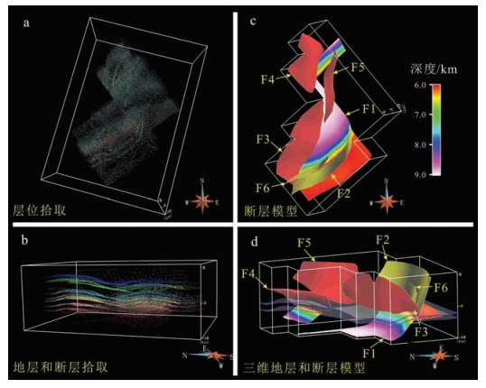
基于大邑背斜三维地震数据构造解释成果,结合相干分析和钻井数据,本文在GOCAD地质三维建模平台上构建了大邑构造三维构造模型[69],以便通过三角面网格识别三维断层构造几何学特征,确认断层之间、断层和背斜或向斜间的空间关系,评价断层几何学沿走向上的变化,讨论深部和浅部构造关系等地下三维构造问题。将Discovery或Land-mark中地震解释模块解释的地层数据和断层数据以离散点方式导出,在GOCAD地质三维建模平台导入这些点数据,使用DSI(离散元插值)[69]算法分别建立断层面模型和地层模型,确立层位和断层、断层和断层的空间切割关系,实现地下三维可视化,该三维构造模型中的断层系统是现今大范围地震灾害的研究基础[70]。首先进行地层点的拾取(图 12-a),其次对地层和断层进行拾取(图 12-b),然后基于断层离散点和断层切割关系建立断面模型(图 12-c),最后基于地层离散点,以及断层和地层的接触关系建立地层模型(图 12-d),从而建立大邑背斜三维构造模型,主要包括7条主要断层和6个地层底界面(分别为二叠系、下三叠统嘉陵江组、中三叠统雷口坡组、上三叠统须家河组、下侏罗统自流井组和上侏罗统遂宁组)(图 12)。在该三维构造模型中,未加入地震剖面中识别的走向延伸小于3km的次级小断层,例如图 4和图 5中左上侧的断层。
大邑背斜中的大邑构造和崇州构造几何学特征在三维构造模型中得以清楚展示。在图 12-d中,由下三叠统嘉陵江组和中三叠统雷口坡组限定的浅部滑脱层系被突出,而蒸发膏岩层在大邑构造较薄,在崇州构造区较厚。大邑构造和崇州构造浅部构造主要受浅部滑脱层系(4~7km深)上部的隐伏逆冲断层改造和控制,而这一滑脱层可向西延伸与龙门山褶皱冲断带深部滑脱层相连。大邑构造主要受深部隐伏的断层转折褶皱控制,其断坡连接了中部9~10km深的志留系滑脱层和浅部4~8km深的下三叠统滑脱层,中部滑脱层也可向西延伸,与龙门山褶皱冲断带深部滑脱层相连。大邑背斜三维构造模型同样展示了2组不同走向的断层F1~F6,包括NE走向的逆冲断层F1、F2和F6,NNE走向的逆冲断层F3、F4和F5(图 12)。
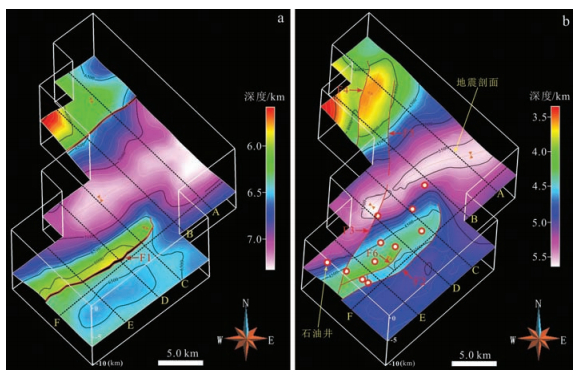
图 13展示了大邑背斜区下三叠统嘉陵江组和上三叠统须家河组底界的地下三维构造模型。下三叠统嘉陵江组三维构造模型揭示,大邑背斜区的大邑构造被深部NE走向的断层F1切割,而崇州构造被另一条深部NE走向的断层切割(图 13-a)。大邑背斜区大邑构造发育西倾的逆冲断层F2和F6,以及东倾的反冲断层F3,而崇州构造发育西倾的逆冲断层F5和东倾的反冲断层,中三叠统、上三叠统、侏罗系和白垩系均被这些断层切割。另外,大邑构造西翼被NNE走向的逆冲断层F3切割,大邑构造背斜区和向斜区也被该断层切割;崇州构造被2条NNE走向的逆冲断层F4和F5限制,断层F4控制NNE走向的背斜区,而断层F5同样切割了大邑构造向斜区西翼(图 13-b)。断层和断层切割关系,以及与相应背斜、向斜的切割关系暗示,大邑背斜区存在2期构造事件。结合地震剖面解释、地震相干分析和三维构造建模,可以确定大邑背斜区发育的NNE向构造晚于NE向构造,而NNE向构造的发育与近EW向的构造缩短作用相关。
4. 晚新生代东西向地壳缩短和构造应力场转换
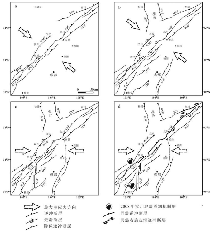
构造应力场转换是现今地球科学研究的热点,晚新生代龙门山褶皱冲断带右旋走滑特征和2008年汶川地震同震斜向挤压逆冲作用暗示,晚新生代存在构造应力场转换。虽然Burchfile等[20]和Wang等[52]已就中生代和新生代龙门山褶皱冲断带的最大主应力场方向问题进行过讨论,但构造应力场演化过程及其相应的构造特征仍然不清。自中生代以来,龙门山褶皱冲断带经历了2期构造缩短事件[20, 24],晚三叠世龙门山在调节SE向逆冲挤压作用下形成了NE东向延伸的龙门山褶皱冲断带和川西前陆盆地,表明早期造山作用为NW-SE向[20, 24](图 14-a)。晚新生代印度-欧亚大陆碰撞的远距离效应使龙门山褶皱冲断带重新被激活[20, 24, 40],但对这一阶段青藏高原东缘的挤压应力方向的认识存在分歧。Avouac等[36]和Zhang等[37]认为,晚新生代造山作用方向与晚三叠世一致,而另一种观点指出,晚新生代龙门山褶皱冲断带构造变形可能包含重要的右旋走滑分量[20, 30, 53],后者与汶川地震同震滑移所揭示的斜向逆冲认识一致[30-31, 38-39, 44, 46-48, 71],暗示晚新生代龙门山褶皱冲断带发生了区域应力场的转变。
![]() 图 14 青藏高原东缘龙门山褶皱冲断带及其邻区构造应力场演化a-晚三叠世水平最大主压应力(σhmax)方向为NW-SE向;b-渐新世-早上新世σhmax为NW-SE向;c-晚上新世-全新世为EW向挤压过程;d-现今测量的和汶川地震反演的近EW向挤压应力场。WMF-汶川-茂汶断裂;YBF-映秀-北川断裂;PGF-彭县-灌县断裂;QCF-青川断裂;MJF-岷江断裂;HYF-虎牙断裂;LRBF-龙日坝断裂;WLF-武龙断裂;BXF-宝兴断裂;DYF-大邑断层;QXF-邛西断层;PLF-平罗坝断层;LQF-龙泉断层;XPF-熊坡断层Figure 14. The evolution of the tectonic stress field in Longmen Mountain and adjacent areas
图 14 青藏高原东缘龙门山褶皱冲断带及其邻区构造应力场演化a-晚三叠世水平最大主压应力(σhmax)方向为NW-SE向;b-渐新世-早上新世σhmax为NW-SE向;c-晚上新世-全新世为EW向挤压过程;d-现今测量的和汶川地震反演的近EW向挤压应力场。WMF-汶川-茂汶断裂;YBF-映秀-北川断裂;PGF-彭县-灌县断裂;QCF-青川断裂;MJF-岷江断裂;HYF-虎牙断裂;LRBF-龙日坝断裂;WLF-武龙断裂;BXF-宝兴断裂;DYF-大邑断层;QXF-邛西断层;PLF-平罗坝断层;LQF-龙泉断层;XPF-熊坡断层Figure 14. The evolution of the tectonic stress field in Longmen Mountain and adjacent areas本次研究表明,大邑背斜区在晚新生代的确存在2期构造事件,分别对应早期的NE向构造和晚期的近NS向构造。平行于龙门山褶皱冲断带的NE向构造存在明显的不连续和被NS向构造切割和限制的特征,而NS向构造在龙门山南段,特别是在四川盆地西南部,呈现为主要的断裂系统,可连续追踪120km[43, 52]。已发表的四川盆地西南部NE向构造的热年代学数据表明,熊坡、平罗和其他NE向构造主要形成于渐新世-中新世[52, 55, 72-73],而地震相干分析和三维构造建模的结果显示,这一区域内NS向构造切割和限制了NE向构造,由此推断,区域内NS向构造形成于中新世之后。地震剖面和野外测量结果表明,NS走向的断层F5切割了大邑砾岩,暗示NS向构造形成于大邑砾岩底部沉积(约3.6Ma)之后。基于大邑背斜区NS向构造延伸特征及其倾滑的位移量,笔者认为,这一构造吸收了近EW向的构造缩短作用(图 14),而大邑背斜区和邛西背斜区NS向断层和褶皱的最新活动性则反映了龙门山南段局部或区域性水平最大主压应力方向从渐新世-早上新世的NW-SE向(如熊坡、龙泉山背斜区反映的构造应力场方向)[20, 52, 55, 72-73](图 14-b)转变为晚上新世-全新世的EW向挤压过程[52](图 14-c)。在龙门山褶皱冲断带和四川盆地西南部,直接测量地壳应力的方法(例如震源机制解、井眼崩落、水力压裂法、断裂滑动反演等)显示,测得的最大水平主压应力方向在85°~105°之间[44, 74],与笔者推测的EW向挤压方向结果一致(图 14-d)。位于研究区东部的龙泉山背斜区为一典型的断坡背斜,其走向由NE向转变为近NS向。这一转变可能指示在EW向挤压应力作用下,背斜的重新活动形成近NS向构造[30, 51]。这一最新的近EW向挤压应力形成的NS向构造与青藏高原东缘龙门山褶皱冲断带主体NE向构造的方向存在斜向逆冲分量,而这一滑动分量与汶川地震反映的斜向逆冲同震破裂样式一致[30, 38, 71](图 14-d)。
龙门山褶皱冲断带南段延伸120km的晚上新世-全新世NS向构造(大邑背斜区和邛西背斜区)切割了渐新世-早上新世的NE向构造和晚更新世名邛冲积扇[20, 52, 55, 72-73],同时,该NS向构造距汶川地震震中只有20km。在龙门山褶皱冲断带和四川盆地西南部地区重新定位的汶川地震余震揭示,震中以北及其附近存在NS向的地震带,震中可能位于NS向地震带与NE向地震带的交汇处[39, 75]。因此,NS向地震带在未来可能存在一定的地震风险。这一区域发育120km长的NS向构造和汶川地震同震变形均反映出青藏高原东缘最新的EW向地壳缩短过程。
5. 结论
(1)浅部塑性滑脱层自北向南减薄,导致大邑背斜区北部的崇州构造深部以塑性变形为主,而南部的大邑构造深部以脆性断层转折褶皱变形为主。大邑背斜前后翼均发育断层切割能干层,浅部断层活动时间为大邑砾岩沉积(约3.6Ma)之后。
(2)大邑背斜区发育近NS向和NE向2期构造,且近NS向构造切割了NE向构造,反映了龙门山南段局部或区域水平最大主应力转换过程,从渐新世-早上新世的NW-SE向转变为晚上新世-全新世的近EW向。
(3)龙门山南段山前发育的120km长的NS向构造和汶川地震同震变形均反映了青藏高原东缘最新的EW向地壳缩短过程。
致谢: 中国石化西南油气分公司提供石油地震反射剖面和钻井数据,西南石油大学陈伟教授给予的宝贵建议,审稿人提出的建设性意见,在此表示衷心的感谢。 -
图 1 青藏高原东缘主要活动断层和大地震分布
a-青藏高原东缘周缘GPS位移场(据参考文献[22]修改);b-青藏高原东缘龙门山褶皱冲断带和四川盆地西部区域构造位置,2008年汶川地震震中位置和震源机制解,同震地表破裂和未破裂的主断层[30, 38-39], 1970年大邑地震、1976年松潘地震和2013年芦山地震震源机制解[34, 42-43]和区域地震剖面位置均在图中标明(最大水平主应力数据修改据参考文献[39, 44]);c-小鱼洞断层地表破裂和同震滑移场(数据修改据参考文献[45-46])。WMF-汶川-茂汶断裂;YBF-映秀-北川断裂;PGF-彭县-灌县断裂;QCF-青川断裂;MJF-岷江断裂;HYF-虎牙断裂;LRBF-龙日坝断裂;WLF-武龙断裂;BXF-宝兴断裂;DYF-大邑断层;QXF-邛西断层;PLF-平罗坝断层;LQF-龙泉断层;XPF-熊坡断层
Figure 1. Main active faults and earthquake events on the eastern margin of the Tibetan Plateau
图 4 过崇州构造北翼的地震剖面A解释方案(剖面位置见图 2)
Pre-P-前二叠系;P-二叠系;T1j-下三叠统嘉陵江组;T2l-中三叠统雷口坡组;T3m-上三叠统马鞍塘组;T3x-上三叠统须家河组;J1-下侏罗统;J2-上侏罗统;K-白垩系;E-古近系;N2-Q1-大邑砾岩;Q-第四系
Figure 4. Interpreted seismic profile A across the Chongzhou structure
图 9 沿走向地震剖面F,展示滑脱层厚度在走向上的变化和F5断层的侧断坡(剖面位置见图 2)
Figure 9. Along-strike NE-trending seismic profile F across the Dayiand Chongzhou structures, showing the along-strike changes of the thickness and lateral ramp of F5 fault
图 14 青藏高原东缘龙门山褶皱冲断带及其邻区构造应力场演化
a-晚三叠世水平最大主压应力(σhmax)方向为NW-SE向;b-渐新世-早上新世σhmax为NW-SE向;c-晚上新世-全新世为EW向挤压过程;d-现今测量的和汶川地震反演的近EW向挤压应力场。WMF-汶川-茂汶断裂;YBF-映秀-北川断裂;PGF-彭县-灌县断裂;QCF-青川断裂;MJF-岷江断裂;HYF-虎牙断裂;LRBF-龙日坝断裂;WLF-武龙断裂;BXF-宝兴断裂;DYF-大邑断层;QXF-邛西断层;PLF-平罗坝断层;LQF-龙泉断层;XPF-熊坡断层
Figure 14. The evolution of the tectonic stress field in Longmen Mountain and adjacent areas
-
Kuncoro A K, Cubas N, Singh S C, et al. Tsunamigenic potential due to frontal rupturing in the Sumatra locked zone[J]. Earth and Planetary Science Letters, 2015, 432:311-322. doi: 10.1016/j.epsl.2015.10.007 Kuncoro A K, Cubas N, Singh S C, et al. Tsunamigenic potential due to frontal rupturing in the Sumatra locked zone[J]. Earth and Planetary Science Letters, 2015, 432:311-322. doi: 10.1016/j.epsl.2015.10.007
Wang K L, He J H. Mechanics of low-stress forearcs:Nankai and Cascadia[J]. Journal of Geophysical Research, 1999, 104(B7):15191-15205. doi: 10.1029/1999JB900103 Wang K L, He J H. Mechanics of low-stress forearcs:Nankai and Cascadia[J]. Journal of Geophysical Research, 1999, 104(B7):15191-15205. doi: 10.1029/1999JB900103
Tsuji T, Ashi J, Strasser M, et al. Identification of the static backstop and its influence on the evolution of the accretionary prism in the Nankai Trough[J]. Earth and Planetary Science Letters, 2015, 431:15-25. doi: 10.1016/j.epsl.2015.09.011 Tsuji T, Ashi J, Strasser M, et al. Identification of the static backstop and its influence on the evolution of the accretionary prism in the Nankai Trough[J]. Earth and Planetary Science Letters, 2015, 431:15-25. doi: 10.1016/j.epsl.2015.09.011
Angermann D, Klotz J, Reigber C. Space-geodetic estimation of the Nazca-South America Euler vector[J]. Earth and Planetary Science Letters, 1999, 171:329-324. doi: 10.1016/S0012-821X(99)00173-9 Angermann D, Klotz J, Reigber C. Space-geodetic estimation of the Nazca-South America Euler vector[J]. Earth and Planetary Science Letters, 1999, 171:329-324. doi: 10.1016/S0012-821X(99)00173-9
Ader T, Avouac J P, Liu-Zeng J, et al. Convergence rate across the Nepal Himalaya and interseismic coupling on the Main Himalayan Thrust:Implications for seismic hazard[J]. Journal of Geophysical Research, 2012, 117:1-16. https://www.researchgate.net/publication/258661893_Convergence_rate_across_the_Nepal_Himalaya_and_interseismic_coupling_on_the_Main_Himalayan_Thrust_Implications_for_seismic_hazard Ader T, Avouac J P, Liu-Zeng J, et al. Convergence rate across the Nepal Himalaya and interseismic coupling on the Main Himalayan Thrust:Implications for seismic hazard[J]. Journal of Geophysical Research, 2012, 117:1-16. https://www.researchgate.net/publication/258661893_Convergence_rate_across_the_Nepal_Himalaya_and_interseismic_coupling_on_the_Main_Himalayan_Thrust_Implications_for_seismic_hazard
Kundu B, Yadav R K, Bali B S, et al. Oblique convergence and slip partitioning in the NW Himalaya:Implications from GPS measurements[J]. Tectonics, 2014, 33, doi: 10.1002/2014TC003633. Kundu B, Yadav R K, Bali B S, et al. Oblique convergence and slip partitioning in the NW Himalaya:Implications from GPS measurements[J]. Tectonics, 2014, 33, doi: 10.1002/2014TC003633.
Rosenberg C L, Brun J P, Cagnard F, et al. Oblique indentation in the Eastern Alps:Insights from laboratory experiments[J]. Tectonics, 2007, 26:TC2003, doi: 10.1029/2006TC001960. Rosenberg C L, Brun J P, Cagnard F, et al. Oblique indentation in the Eastern Alps:Insights from laboratory experiments[J]. Tectonics, 2007, 26:TC2003, doi: 10.1029/2006TC001960.
Castelltort S, Goren L, Willett S D, et al. River drainage patterns in the New Zealand Alps primarily controlled by plate tectonic strain[J]. Nature Geoscience, 2012, doi: 10.1038/NGEO1582. Castelltort S, Goren L, Willett S D, et al. River drainage patterns in the New Zealand Alps primarily controlled by plate tectonic strain[J]. Nature Geoscience, 2012, doi: 10.1038/NGEO1582.
Chang C P, Chang T Y, Angelier J, et al. Strain and stress field in Taiwan oblique convergent system:constraints from GPS observation and tectonic data[J]. Earth and Planetary Science Letters, 2003, 214:115-127. doi: 10.1016/S0012-821X(03)00360-1 Chang C P, Chang T Y, Angelier J, et al. Strain and stress field in Taiwan oblique convergent system:constraints from GPS observation and tectonic data[J]. Earth and Planetary Science Letters, 2003, 214:115-127. doi: 10.1016/S0012-821X(03)00360-1
Chen Y G, Lai K Y, Lee Y H, et al. Coseismic fold scarps and their kinematic behavior in the 1999 Chi-Chi earthquake Taiwan[J]. Journal of Geophysical Research, 2007, 112:B03S02, doi: 10.1029/2006JB004388. Chen Y G, Lai K Y, Lee Y H, et al. Coseismic fold scarps and their kinematic behavior in the 1999 Chi-Chi earthquake Taiwan[J]. Journal of Geophysical Research, 2007, 112:B03S02, doi: 10.1029/2006JB004388.
Norabuena E, Leffler-Griffin L, Mao L, et al. Space Geodetic Observations of Nazca-South America Convergence Across the Central Andes[J]. Science, 1998, 279, doi: 10.1126/science.279.5349.358. Norabuena E, Leffler-Griffin L, Mao L, et al. Space Geodetic Observations of Nazca-South America Convergence Across the Central Andes[J]. Science, 1998, 279, doi: 10.1126/science.279.5349.358.
Vargas G, Klinger Y, Rockwell T K, et al. Probing large intraplate earthquakes at the west flank of the Andes[J]. Geology, 2014, 42, 1083-1086. doi: 10.1130/G35741.1 Vargas G, Klinger Y, Rockwell T K, et al. Probing large intraplate earthquakes at the west flank of the Andes[J]. Geology, 2014, 42, 1083-1086. doi: 10.1130/G35741.1
Authemayou C, Chardon D, Bellier O, et al. Late Cenozoic partitioning of oblique plate convergence in the Zagros fold-andthrust belt (Iran)[J]. Tectonics, 2006, 25, doi: 10.1029/2005TC001860. Authemayou C, Chardon D, Bellier O, et al. Late Cenozoic partitioning of oblique plate convergence in the Zagros fold-andthrust belt (Iran)[J]. Tectonics, 2006, 25, doi: 10.1029/2005TC001860.
Tavakoli F, Walpersdorf A, Authemayou C, et al. Distribution of the right-lateral strike-slip motion from the Main Recent Fault to the Kazerun Fault System (Zagros, Iran):Evidence from presentday GPS velocities[J]. Earth and Planetary Science Letters, 2008, 275:342-347. doi: 10.1016/j.epsl.2008.08.030 Tavakoli F, Walpersdorf A, Authemayou C, et al. Distribution of the right-lateral strike-slip motion from the Main Recent Fault to the Kazerun Fault System (Zagros, Iran):Evidence from presentday GPS velocities[J]. Earth and Planetary Science Letters, 2008, 275:342-347. doi: 10.1016/j.epsl.2008.08.030
Bilham R, Gaur V K, Molnar P. Himalayan seismic hazard[J]. Science, 2001, 293:1442-1444. doi: 10.1126/science.1062584 Bilham R, Gaur V K, Molnar P. Himalayan seismic hazard[J]. Science, 2001, 293:1442-1444. doi: 10.1126/science.1062584
Subarya C, Chlieh M, Prawirodirdjo L, et al. Plate-boundary deformation associated with the great Sumatra-Andaman earthquake[J]. Nature, 2006, 440:46-51. doi: 10.1038/nature04522 Subarya C, Chlieh M, Prawirodirdjo L, et al. Plate-boundary deformation associated with the great Sumatra-Andaman earthquake[J]. Nature, 2006, 440:46-51. doi: 10.1038/nature04522
Murphy M A, Taylor M H, Gosse J, et al. Limit of strain partitioning in the Himalaya marked by large earthquakes in western Nepal[J]. Nature Geoscience, 2014, 7:38-42. http://www.nature.com/ngeo/journal/v7/n1/abs/ngeo2017.html Murphy M A, Taylor M H, Gosse J, et al. Limit of strain partitioning in the Himalaya marked by large earthquakes in western Nepal[J]. Nature Geoscience, 2014, 7:38-42. http://www.nature.com/ngeo/journal/v7/n1/abs/ngeo2017.html
McClay K R, Whitehouse P S, Dooley T, et al. 3D evolution of fold and thrust belts formed by oblique convergence[J]. Marine and Petroleum Geology, 2004, 21:857-877. doi: 10.1016/j.marpetgeo.2004.03.009 McClay K R, Whitehouse P S, Dooley T, et al. 3D evolution of fold and thrust belts formed by oblique convergence[J]. Marine and Petroleum Geology, 2004, 21:857-877. doi: 10.1016/j.marpetgeo.2004.03.009
Upton P, Craw D. Coeval emplacement and orogen-parallel transport of gold in oblique convergent orogens[J]. Tectonophysics, 2016, http://dx.doi.org/10.1016/j.tecto.2016.01.015. doi: 10.1016/j.tecto.2016.01.015 Upton P, Craw D. Coeval emplacement and orogen-parallel transport of gold in oblique convergent orogens[J]. Tectonophysics, 2016, http://dx.doi.org/10.1016/j.tecto.2016.01.015. doi: 10.1016/j.tecto.2016.01.015
Burchfiel B C, Chen Z L, Liu Y P, et al. Tectonics of the Longmen Shan and adjacent regions, central China[J]. International Geology Review, 1995, 37:661-735. doi: 10.1080/00206819509465424 Burchfiel B C, Chen Z L, Liu Y P, et al. Tectonics of the Longmen Shan and adjacent regions, central China[J]. International Geology Review, 1995, 37:661-735. doi: 10.1080/00206819509465424
Robert A, Pubellier M, de Sigoyer J, et al. Structural and thermal characters of the Longmen Shan (Sichuan, China)[J]. Tectonophysics, 2010, 491:165-173. doi: 10.1016/j.tecto.2010.03.018 Robert A, Pubellier M, de Sigoyer J, et al. Structural and thermal characters of the Longmen Shan (Sichuan, China)[J]. Tectonophysics, 2010, 491:165-173. doi: 10.1016/j.tecto.2010.03.018
Wang Q, Zhang P Z, Freymueller J T, et al. Present-Day crustal deformation in China constrained by Global Positioning System measurements[J]. Science, 2001, 294:574-577. doi: 10.1126/science.1063647 Wang Q, Zhang P Z, Freymueller J T, et al. Present-Day crustal deformation in China constrained by Global Positioning System measurements[J]. Science, 2001, 294:574-577. doi: 10.1126/science.1063647
Burchfiel B C, Royden L H, van der Hilst R D, et al. A geological and geophysical context for the Wenchuan earthquake of 12 May 2008, Sichuan, People's Republic of China[J]. GSA Today, 2008, 18:4-11. http://d.wanfangdata.com.cn/NSTLQK_NSTL_QKJJ0213989097.aspx Burchfiel B C, Royden L H, van der Hilst R D, et al. A geological and geophysical context for the Wenchuan earthquake of 12 May 2008, Sichuan, People's Republic of China[J]. GSA Today, 2008, 18:4-11. http://d.wanfangdata.com.cn/NSTLQK_NSTL_QKJJ0213989097.aspx
Jia D, Wei G Q, Chen Z X, et al. Longmen Shan fold-thrust belt and its relation to the western Basin in Central China:New insights from hydrocarbon exploration[J]. AAPG Bulletin, 2006, 90:1425-1447. doi: 10.1306/03230605076 Jia D, Wei G Q, Chen Z X, et al. Longmen Shan fold-thrust belt and its relation to the western Basin in Central China:New insights from hydrocarbon exploration[J]. AAPG Bulletin, 2006, 90:1425-1447. doi: 10.1306/03230605076
李勇, 周荣军, Densmore A L, 等.青藏高原东缘龙门山晚新生代走滑挤压作用的沉积响应[J].地质学报, 2006, 24:153-164. http://www.cnki.com.cn/Article/CJFDTOTAL-CJXB200602000.htm Royden L H, Burchfiel B C, King R W, et al. Surface deformation and lower crustal flow in Eastern Tibet[J]. Science, 1997, 276:788-790. doi: 10.1126/science.276.5313.788 Royden L H, Burchfiel B C, King R W, et al. Surface deformation and lower crustal flow in Eastern Tibet[J]. Science, 1997, 276:788-790. doi: 10.1126/science.276.5313.788
Royden L H, Burchfiel B C, Hilst R D, et al. The geological evolution of the Tibetan Plateau[J]. Science, 2008, 321:1054-1058. doi: 10.1126/science.1155371 Royden L H, Burchfiel B C, Hilst R D, et al. The geological evolution of the Tibetan Plateau[J]. Science, 2008, 321:1054-1058. doi: 10.1126/science.1155371
Clark M K, Royden L H. Topographic ooze:building the eastern margin of Tibet by lower crustal flow[J]. Geology, 2000, 28:703-706. doi: 10.1130/0091-7613(2000)28<703:TOBTEM>2.0.CO;2 Clark M K, Royden L H. Topographic ooze:building the eastern margin of Tibet by lower crustal flow[J]. Geology, 2000, 28:703-706. doi: 10.1130/0091-7613(2000)28<703:TOBTEM>2.0.CO;2
Hubbard J, Shaw J H. Uplift of the Longmen Shan and Tibetan plateau, and the 2008 Wenchuan (M=7.9) earthquake[J]. Nature, 2009, 458:194-197. doi: 10.1038/nature07837 Hubbard J, Shaw J H. Uplift of the Longmen Shan and Tibetan plateau, and the 2008 Wenchuan (M=7.9) earthquake[J]. Nature, 2009, 458:194-197. doi: 10.1038/nature07837
Liuzeng J, Zhang Z, Wen L, et al. Co-seismic ruptures of the 12 May 2008, Ms 8.0 Wenchuan earthquake, Sichuan:East-west crustal shortening on oblique, parallel thrusts along the eastern edge of Tibet[J]. Earth and Planetary Science Letters, 2009, 286:355-370. doi: 10.1016/j.epsl.2009.07.017 Liuzeng J, Zhang Z, Wen L, et al. Co-seismic ruptures of the 12 May 2008, Ms 8.0 Wenchuan earthquake, Sichuan:East-west crustal shortening on oblique, parallel thrusts along the eastern edge of Tibet[J]. Earth and Planetary Science Letters, 2009, 286:355-370. doi: 10.1016/j.epsl.2009.07.017
Zhang P Z, Wen X Z, Shen Z K, et al. Oblique, High-angle, listric-reverse faulting and associated development of strain:The Wenchuan earthquake of May 12, 2008, Sichuan, China[J]. Annual Review Earth and Planetary Sciences, 2010, 38:353-382. doi: 10.1146/annurev-earth-040809-152602 Zhang P Z, Wen X Z, Shen Z K, et al. Oblique, High-angle, listric-reverse faulting and associated development of strain:The Wenchuan earthquake of May 12, 2008, Sichuan, China[J]. Annual Review Earth and Planetary Sciences, 2010, 38:353-382. doi: 10.1146/annurev-earth-040809-152602
Tapponnier P, Xu Z Q, Roger F, et al. Oblique stepwise rise and growth of the Tibet Plateau[J]. Science, 2001, 294:1671-1677. doi: 10.1126/science.105978 Tapponnier P, Xu Z Q, Roger F, et al. Oblique stepwise rise and growth of the Tibet Plateau[J]. Science, 2001, 294:1671-1677. doi: 10.1126/science.105978
Guo X Y, Gao R, Keller G R, et al. Imaging the crustal structure beneath the eastern Tibetan Plateau and implications for the uplift of the Longmen Shan range[J]. Earth and Planetary Science Letters, 2013, 379:72-80. doi: 10.1016/j.epsl.2013.08.005 Guo X Y, Gao R, Keller G R, et al. Imaging the crustal structure beneath the eastern Tibetan Plateau and implications for the uplift of the Longmen Shan range[J]. Earth and Planetary Science Letters, 2013, 379:72-80. doi: 10.1016/j.epsl.2013.08.005
Zhang P Z. A review on active tectonics and deep crustal processes of the Western Sichuan region, eastern margin of the Tibetan Plateau[J]. Tectonophysics, 2013, 584:7-22. doi: 10.1016/j.tecto.2012.02.021 Zhang P Z. A review on active tectonics and deep crustal processes of the Western Sichuan region, eastern margin of the Tibetan Plateau[J]. Tectonophysics, 2013, 584:7-22. doi: 10.1016/j.tecto.2012.02.021
Liu Q Y, van der Hilst R D, Li Y, et al. Eastward expansion of the Tibetan Plateau by crustal fl ow and strain partitioning across faults[J]. Nature Geoscience, 2014, 7:361-365. doi: 10.1038/ngeo2130 Liu Q Y, van der Hilst R D, Li Y, et al. Eastward expansion of the Tibetan Plateau by crustal fl ow and strain partitioning across faults[J]. Nature Geoscience, 2014, 7:361-365. doi: 10.1038/ngeo2130
Avouac J P, Tapponnier P. Kinematical model of active deformation in central Asia[J]. Geophysical Research Letters, 1993, 20:895-898. doi: 10.1029/93GL00128 Avouac J P, Tapponnier P. Kinematical model of active deformation in central Asia[J]. Geophysical Research Letters, 1993, 20:895-898. doi: 10.1029/93GL00128
Zhang P Z, Shen Z K, Wang M, et al. Continuous deformation of the Tibetan Plateau from global positioning system data[J]. Geology, 2004, 32:809-812. doi: 10.1130/G20554.1 Zhang P Z, Shen Z K, Wang M, et al. Continuous deformation of the Tibetan Plateau from global positioning system data[J]. Geology, 2004, 32:809-812. doi: 10.1130/G20554.1
Xu X W, Wen X Z, Yu G H, et al. Coseismic reverse-and oblique-slip surface faulting generated by the 2008 Mw 7.9 Wenchuan earthquake, China[J]. Geology, 2009, 37:515-518. doi: 10.1130/G25462A.1 Xu X W, Wen X Z, Yu G H, et al. Coseismic reverse-and oblique-slip surface faulting generated by the 2008 Mw 7.9 Wenchuan earthquake, China[J]. Geology, 2009, 37:515-518. doi: 10.1130/G25462A.1
Wang Q, Qiao X J, Lan Q G, et al. Rupture of deep faults in the 2008 Wenchuan earthquake and uplift of the Longmen Shan[J]. Nature Geoscience, 2011, 4:634-640. doi: 10.1038/ngeo1210 Wang Q, Qiao X J, Lan Q G, et al. Rupture of deep faults in the 2008 Wenchuan earthquake and uplift of the Longmen Shan[J]. Nature Geoscience, 2011, 4:634-640. doi: 10.1038/ngeo1210
Chen S F, Wilson C J L. Emplacement of the Longmen Shan thrustnappe belt along the eastern margin of the Tibetan Plateau[J]. Journal of Structural Geology, 1996, 18:413-430. https://www.researchgate.net/publication/280800842_Emplacement_of_the_Longmen_Shan_Thrust-Nappe_Belt_along_the_eastern_margin_of_the_Tibetan_Plateau Chen S F, Wilson C J L. Emplacement of the Longmen Shan thrustnappe belt along the eastern margin of the Tibetan Plateau[J]. Journal of Structural Geology, 1996, 18:413-430. https://www.researchgate.net/publication/280800842_Emplacement_of_the_Longmen_Shan_Thrust-Nappe_Belt_along_the_eastern_margin_of_the_Tibetan_Plateau
Li Y, Allen P A, Densmore A L, et al. Evolution of the Longmen Shan foreland basin (western Sichuan, China) during the late Triassic Indosinian orogeny[J]. Basin Research, 2003, 15:117-138. doi: 10.1046/j.1365-2117.2003.00197.x Li Y, Allen P A, Densmore A L, et al. Evolution of the Longmen Shan foreland basin (western Sichuan, China) during the late Triassic Indosinian orogeny[J]. Basin Research, 2003, 15:117-138. doi: 10.1046/j.1365-2117.2003.00197.x
Jones L M, Han W B, Hausson E, et al. Focal mechanism and aftershock locations of the Songpan earthquakes of August 1976 in Sichuan, China[J]. Journal of Geophysical Research, 1984, 89:7697-7707. doi: 10.1029/JB089iB09p07697 Jones L M, Han W B, Hausson E, et al. Focal mechanism and aftershock locations of the Songpan earthquakes of August 1976 in Sichuan, China[J]. Journal of Geophysical Research, 1984, 89:7697-7707. doi: 10.1029/JB089iB09p07697
Li Z G, Jia D, Chen W, et al. Late Cenozoic east-west crustal shortening in the southern Longmen Shan, eastern Tibet:Implications for regional stress field changes[J]. Tectonophysics, 2014, 623:169-186. doi: 10.1016/j.tecto.2014.03.033 Li Z G, Jia D, Chen W, et al. Late Cenozoic east-west crustal shortening in the southern Longmen Shan, eastern Tibet:Implications for regional stress field changes[J]. Tectonophysics, 2014, 623:169-186. doi: 10.1016/j.tecto.2014.03.033
Du Y, Xie F R, Zhang X L, et al. The mechanics of fault slip of Ms 8.0 Wenchuan earthquake[J]. Chinese Journal of Geophysical, 2009, 52:464-473. http://manu39.magtech.com.cn/Geophy/EN/abstract/abstract926.shtml Du Y, Xie F R, Zhang X L, et al. The mechanics of fault slip of Ms 8.0 Wenchuan earthquake[J]. Chinese Journal of Geophysical, 2009, 52:464-473. http://manu39.magtech.com.cn/Geophy/EN/abstract/abstract926.shtml
Shen Z K, Sun J B, Zhang Z P, et al. Slip maxima at fault junctions and rupturing of barriers during the 2008 Wenchuan earthquake[J]. Nature Geoscience, 2009, 2:718-724. doi: 10.1038/ngeo636 Shen Z K, Sun J B, Zhang Z P, et al. Slip maxima at fault junctions and rupturing of barriers during the 2008 Wenchuan earthquake[J]. Nature Geoscience, 2009, 2:718-724. doi: 10.1038/ngeo636
Liu Z J, Sun J, Wang P, et al. Surface ruptures on the transverse Xiaoyudong fault:A significant segment boundary breached during the 2008 Wenchuan earthquake, China[J]. Tectonophysics, 2012, 580:218-241. doi: 10.1016/j.tecto.2012.09.024 Liu Z J, Sun J, Wang P, et al. Surface ruptures on the transverse Xiaoyudong fault:A significant segment boundary breached during the 2008 Wenchuan earthquake, China[J]. Tectonophysics, 2012, 580:218-241. doi: 10.1016/j.tecto.2012.09.024
Jia D, Li Y Q, Lin A M, et al. Structural model of 2008 Mw 7.9 Wenchuan earthquake in the rejuvenated Longmen Shan thrust belt, China[J]. Tectonophysics, 2010, 491:174-184. doi: 10.1016/j.tecto.2009.08.040 Jia D, Li Y Q, Lin A M, et al. Structural model of 2008 Mw 7.9 Wenchuan earthquake in the rejuvenated Longmen Shan thrust belt, China[J]. Tectonophysics, 2010, 491:174-184. doi: 10.1016/j.tecto.2009.08.040
Li Y Q, Jia D, Shaw J H, et al. Structural interpretation of the coseismic faults of the Wenchuan earthquake:Three-dimensional modeling of the Longmen Shan fold-and-thrust belt[J]. Journal of Geophysical Research, 2010, 115:1-26. https://www.researchgate.net/publication/248805410_Structural_interpretation_of_the_coseismic_faults_of_the_Wenchuan_earthquake_Three-dimensional_modeling_of_the_Longmen_Shan_fold-and-thrust_belt Li Y Q, Jia D, Shaw J H, et al. Structural interpretation of the coseismic faults of the Wenchuan earthquake:Three-dimensional modeling of the Longmen Shan fold-and-thrust belt[J]. Journal of Geophysical Research, 2010, 115:1-26. https://www.researchgate.net/publication/248805410_Structural_interpretation_of_the_coseismic_faults_of_the_Wenchuan_earthquake_Three-dimensional_modeling_of_the_Longmen_Shan_fold-and-thrust_belt
Jin W Z, Tang L J, Yang K M, et al. Segmentation of the Longmen Mountains thrust belt, Western Sichuan Foreland Basin, SW China[J]. Tectonophysics, 2010, 485:107-121. doi: 10.1016/j.tecto.2009.12.007 Jin W Z, Tang L J, Yang K M, et al. Segmentation of the Longmen Mountains thrust belt, Western Sichuan Foreland Basin, SW China[J]. Tectonophysics, 2010, 485:107-121. doi: 10.1016/j.tecto.2009.12.007
Hubbard J, Shaw J H, Klinger Y. Structural setting of the 2008Mw 7.9 Wenchuan, China, earthquake[J]. Bulletin of the Seismological Society of America, 2010, 100:2713-2735. doi: 10.1785/0120090341 Hubbard J, Shaw J H, Klinger Y. Structural setting of the 2008Mw 7.9 Wenchuan, China, earthquake[J]. Bulletin of the Seismological Society of America, 2010, 100:2713-2735. doi: 10.1785/0120090341
Li Z G, Jia D, Chen W, et al. Structural geometry and deformation mechanism of the Longquan anticline in the Longmen Shan foldand-thrust belt, eastern Tibet[J]. Journal of Asian Earth Sciences, 2013, 64:223-234. doi: 10.1016/j.jseaes.2012.12.022 Li Z G, Jia D, Chen W, et al. Structural geometry and deformation mechanism of the Longquan anticline in the Longmen Shan foldand-thrust belt, eastern Tibet[J]. Journal of Asian Earth Sciences, 2013, 64:223-234. doi: 10.1016/j.jseaes.2012.12.022
Wang M M, Jia D, Lin A M, et al. Active fault-related folding beneath an alluvial terrace in the southern Longmen Shan range front, Sichuan basin, China:Implications for seismic hazard[J]. Bulletin of the Seismological Society of America, 2013, 103:2369-2385. doi: 10.1785/0120120188 Wang M M, Jia D, Lin A M, et al. Active fault-related folding beneath an alluvial terrace in the southern Longmen Shan range front, Sichuan basin, China:Implications for seismic hazard[J]. Bulletin of the Seismological Society of America, 2013, 103:2369-2385. doi: 10.1785/0120120188
Densmore A L, Ellis M A, Li Y, et al. Active tectonics of the Beichuan and Pengguan faults at the eastern margin of the Tibetan Plateau[J]. Tectonics, 2007, 26:1-17. http://en.cnki.com.cn/Article_en/CJFDTOTAL-DZYC200802002.htm Densmore A L, Ellis M A, Li Y, et al. Active tectonics of the Beichuan and Pengguan faults at the eastern margin of the Tibetan Plateau[J]. Tectonics, 2007, 26:1-17. http://en.cnki.com.cn/Article_en/CJFDTOTAL-DZYC200802002.htm
Tang R, Han W. Active Faults and Earthquakes in Sichuan Province[M]. Seismological Press, Beijing, 1993. Tang R, Han W. Active Faults and Earthquakes in Sichuan Province[M]. Seismological Press, Beijing, 1993.
Richardson N J, Densmore A L, Seward D, et al. Extraordinary denudation in the Sichuan Basin:Insights from low-temperature thermochronology adjacent to the eastern margin of the Tibetan Plateau[J]. Journal of Geophysical Research, 2008, 113:1-23. doi: 10.1029/2006JB004739/full Richardson N J, Densmore A L, Seward D, et al. Extraordinary denudation in the Sichuan Basin:Insights from low-temperature thermochronology adjacent to the eastern margin of the Tibetan Plateau[J]. Journal of Geophysical Research, 2008, 113:1-23. doi: 10.1029/2006JB004739/full
黎兵, 李勇, 张开均, 等.青藏高原东缘晚新生代大邑砾岩的物源分析与水系变迁[J].第四纪研究, 2007, 27:64-73. http://www.cnki.com.cn/Article/CJFDTOTAL-DSJJ200701007.htm Li Z W, Liu S G, Chen H D, et al. Spatial variation in Meso-Cenozoic exhumation history of the Longmen Shan thrust belt (eastern Tibetan Plateau) and the adjacent western Sichuan basin:Constraints from fi ssion track thermochronology[J]. Journal of Asian Earth Sciences, 2012, 47:185-203. doi: 10.1016/j.jseaes.2011.10.016 Li Z W, Liu S G, Chen H D, et al. Spatial variation in Meso-Cenozoic exhumation history of the Longmen Shan thrust belt (eastern Tibetan Plateau) and the adjacent western Sichuan basin:Constraints from fi ssion track thermochronology[J]. Journal of Asian Earth Sciences, 2012, 47:185-203. doi: 10.1016/j.jseaes.2011.10.016
Kong P, Zheng Y, Fu B H. Cosmogenic nuclide burial ages and provenance of Late Cenozoic deposits in the Sichuan Basin:Implications for Early Quaternary glaciations in east Tibet[J]. Quaternary Geochronology, 2011, 6:304-312. doi: 10.1016/j.quageo.2011.03.006 Kong P, Zheng Y, Fu B H. Cosmogenic nuclide burial ages and provenance of Late Cenozoic deposits in the Sichuan Basin:Implications for Early Quaternary glaciations in east Tibet[J]. Quaternary Geochronology, 2011, 6:304-312. doi: 10.1016/j.quageo.2011.03.006
董绍鹏, 韩竹军, 尹金辉, 等.龙门山山前大邑断裂活动时代与最新构造变形样式初步研究[J].地震地质, 2008, 30:996-1003. http://www.cnki.com.cn/Article/CJFDTOTAL-DZDZ200804018.htm 李永昭, 郭兵.成都平原的晚新生代构造[J].成都理工大学学报(自然科学版), 2008, 35:371-376. http://www.cnki.com.cn/Article/CJFDTOTAL-CDLG200804004.htm Suppe J, Connors C D, Zhang Y K, et al. Shear fault-bend folding[C]//McClay K R. Thrust Tectonics and Hydrocarbon Systems:AAPG Memoir, 2004, 82:303-323. Suppe J, Connors C D, Zhang Y K, et al. Shear fault-bend folding[C]//McClay K R. Thrust Tectonics and Hydrocarbon Systems:AAPG Memoir, 2004, 82:303-323.
Shaw J H, Connors C D, Suppe J, et al. Seismic interpretation of contractional fault-related folds[M]. An AAPG Seismic Atlas Studies in Geology #53, 2005:8-56. Shaw J H, Connors C D, Suppe J, et al. Seismic interpretation of contractional fault-related folds[M]. An AAPG Seismic Atlas Studies in Geology #53, 2005:8-56.
Graveleau F, Malavieille J, Dominguez S. Experimental modelling of orogenic wedges:A review[J]. Tectonophysics, 2012, 538/540:1-66. doi: 10.1016/j.tecto.2012.01.027 Graveleau F, Malavieille J, Dominguez S. Experimental modelling of orogenic wedges:A review[J]. Tectonophysics, 2012, 538/540:1-66. doi: 10.1016/j.tecto.2012.01.027
Couzens-Schultz B A, Vendeville B C, Wiltschko D V. Duplex style and triangle zone formation:insights from physical modeling[J]. Journal of Structural Geology, 2003, 25:1623-1644. doi: 10.1016/S0191-8141(03)00004-X Couzens-Schultz B A, Vendeville B C, Wiltschko D V. Duplex style and triangle zone formation:insights from physical modeling[J]. Journal of Structural Geology, 2003, 25:1623-1644. doi: 10.1016/S0191-8141(03)00004-X
Ruh J B, Kaus B J P, Burg J P, et al. Numerical investigation of deformation mechanics in fold-and-thrust belts:Influence of rheology of single and multiple décollements[J]. Tectonics, 2012, 31:1-32. https://www.researchgate.net/profile/Boris_Kaus/publication/233906712_Numerical_investigation_of_deformation_mechanics_in_fold-and-thrust_belts_Influence_of_rheology_of_single_and_multiple_decollements/links/0deec52714ad361ff9000000.pdf Ruh J B, Kaus B J P, Burg J P, et al. Numerical investigation of deformation mechanics in fold-and-thrust belts:Influence of rheology of single and multiple décollements[J]. Tectonics, 2012, 31:1-32. https://www.researchgate.net/profile/Boris_Kaus/publication/233906712_Numerical_investigation_of_deformation_mechanics_in_fold-and-thrust_belts_Influence_of_rheology_of_single_and_multiple_decollements/links/0deec52714ad361ff9000000.pdf
Medwedeff D A, Suppe J. Multibend fault-bend folding[J]. Journal of Structural Geology, 1997, 19:279-292. doi: 10.1016/S0191-8141(97)83026-X Medwedeff D A, Suppe J. Multibend fault-bend folding[J]. Journal of Structural Geology, 1997, 19:279-292. doi: 10.1016/S0191-8141(97)83026-X
Bahorich M S, Farmer S L. 3-D seismic discontinuity for faults and stratigraphic features[J]. The Leading Edge, 1995, 14:1053-1058. doi: 10.1190/1.1437077 Bahorich M S, Farmer S L. 3-D seismic discontinuity for faults and stratigraphic features[J]. The Leading Edge, 1995, 14:1053-1058. doi: 10.1190/1.1437077
Bahorich M S, Farmer S L. Methods of seismic signal processing and exploration[J]. U.S. Patent No. 5, 1996, 563:949. http://cn.bing.com/academic/profile?id=1849907805&encoded=0&v=paper_preview&mkt=zh-cn Bahorich M S, Farmer S L. Methods of seismic signal processing and exploration[J]. U.S. Patent No. 5, 1996, 563:949. http://cn.bing.com/academic/profile?id=1849907805&encoded=0&v=paper_preview&mkt=zh-cn
Mallet J L. Discrete smooth interpolation in geometric modeling[J]. Computer Aided Design, 1992, 24:178-191. doi: 10.1016/0010-4485(92)90054-E Mallet J L. Discrete smooth interpolation in geometric modeling[J]. Computer Aided Design, 1992, 24:178-191. doi: 10.1016/0010-4485(92)90054-E
Plesch A, Shaw J H, Benson C, et al. Community fault model (CFM) for southern California[J]. Bulletin of the Seismological Society of America, 2007, 97:1793-1802. doi: 10.1785/0120050211 Plesch A, Shaw J H, Benson C, et al. Community fault model (CFM) for southern California[J]. Bulletin of the Seismological Society of America, 2007, 97:1793-1802. doi: 10.1785/0120050211
Luna L M, Hetland E A. Regional stresses inferred from coseismic slip models of the 2008 Mw 7.9 Wenchuan, China, earthquake[J]. Tectonophysics, 2013, 584:43-53. doi: 10.1016/j.tecto.2012.03.027 Luna L M, Hetland E A. Regional stresses inferred from coseismic slip models of the 2008 Mw 7.9 Wenchuan, China, earthquake[J]. Tectonophysics, 2013, 584:43-53. doi: 10.1016/j.tecto.2012.03.027
Arne D, Worley B, Wilson C, et al. Differential exhumation in response to episodic thrusting along the eastern margin of the Tibetan Plateau[J]. Tectonophysics, 1997, 280:239-256. doi: 10.1016/S0040-1951(97)00040-1 Arne D, Worley B, Wilson C, et al. Differential exhumation in response to episodic thrusting along the eastern margin of the Tibetan Plateau[J]. Tectonophysics, 1997, 280:239-256. doi: 10.1016/S0040-1951(97)00040-1
Kirby E, Reiners P W, Krol M A, et al. Late Cenozoic evolution of the eastern margin of the Tibetan Plateau:Inferences from 40Ar/39Ar and (U-Th)/He thermochronology[J]. Tectonics, 2002, 21:1-20. Kirby E, Reiners P W, Krol M A, et al. Late Cenozoic evolution of the eastern margin of the Tibetan Plateau:Inferences from 40Ar/39Ar and (U-Th)/He thermochronology[J]. Tectonics, 2002, 21:1-20.
Zhang Y Q, Dong S W, Yang N, et al. Active faulting pattern, present-day tectonic stress field and block kinematics in the east Tibetan Plateau[J]. Acta geological Sincia, 2009, 83:694-712. doi: 10.1111/j.1755-6724.2009.00093.x Zhang Y Q, Dong S W, Yang N, et al. Active faulting pattern, present-day tectonic stress field and block kinematics in the east Tibetan Plateau[J]. Acta geological Sincia, 2009, 83:694-712. doi: 10.1111/j.1755-6724.2009.00093.x
Zhu A L, Xu X W, Zhou Y S, et al. Relocation of small earthquakes in western Sichuan, China and its implications for active tectonics[J]. Chinese Journal of Geophysics, 2005, 48:629-636. http://manu39.magtech.com.cn/Geophy/EN/abstract/abstract721.shtml Zhu A L, Xu X W, Zhou Y S, et al. Relocation of small earthquakes in western Sichuan, China and its implications for active tectonics[J]. Chinese Journal of Geophysics, 2005, 48:629-636. http://manu39.magtech.com.cn/Geophy/EN/abstract/abstract721.shtml
-
期刊类型引用(25)
1. 毕晨曦,刘亮明,周飞虎. 融合动力学模拟的机器学习三维成矿预测:以安徽铜山铜矿为例. 大地构造与成矿学. 2025(01): 103-116 .  百度学术
百度学术
2. 李维禄,高思宇,杨锦坤,韩春花,韦广昊,孔敏. 面向多金属结核资源评价的大数据挖掘与融合. 吉林大学学报(地球科学版). 2025(01): 340-350 .  百度学术
百度学术
3. 张村,贾胜,华埜,宋启. 矿山三维地质建模研究进展:原理、方法与应用. 煤炭科学技术. 2025(02): 222-238 .  百度学术
百度学术
4. 徐昌,杨真亮,赵庆鑫,林永成,刘志宁. 澳大利亚昆士兰州Goldsmiths金矿体三维地质建模与矿体储量计算研究. 山东国土资源. 2024(09): 59-66 .  百度学术
百度学术
5. 马鑫,何叶,李金洲,张庚,张新乐,吴夏涛,周家喜,殷桂圆. 四川拉拉铜矿区ASTER和GF-5号卫星数据蚀变矿物弱信息提取. 矿物学报. 2024(06): 898-910 .  百度学术
百度学术
6. 邱云飞,邢浩然,李刚. 矿井建设知识图谱构建研究综述. 计算机工程与应用. 2023(07): 64-79 .  百度学术
百度学术
7. 鲍宽乐,许文波,王庆同. 基于机器学习的Landsat数据地层信息提取——以西南天山柯坪地区为例. 地质通报. 2023(04): 637-645 .  本站查看
本站查看
8. 欧阳渊,刘洪,李光明,马东方,张林奎,黄瀚霄,张景华,张腾蛟,柳潇,赵银兵,李富. 基于随机森林算法的找矿预测——以冈底斯成矿带西段斑岩——浅成低温热液型铜多金属矿为例. 中国地质. 2023(02): 303-330 .  百度学术
百度学术
9. 林成贵,程志中,陈辉,吕志成,庞振山,陈鑫,沈和明. 四川省红泥坡铜矿原生晕特征及找矿方向. 中国地质. 2023(03): 837-852 .  百度学术
百度学术
10. 张宏飞. 省级三维立体自然资源“一张图”建设方案研究与应用——以新疆为例. 测绘与空间地理信息. 2023(07): 111-113+116 .  百度学术
百度学术
11. 许逢明,赵院冬,李成立,崔健,吴大天,孙巍. 黑龙江多宝山矿集区三维地质建模与深部找矿预测. 地质与勘探. 2022(03): 629-652 .  百度学术
百度学术
12. 熊玖琦,刘星. 基于支持向量机的顾北煤矿北一矿区三维地质模型构建. 科学技术与工程. 2022(19): 8194-8199 .  百度学术
百度学术
13. 李希元,崔健,胡望水,李成立. 基于多源地球物理数据的机器学习方法在地质体分类中的应用——以黑龙江多宝山矿集区为例. 地球物理学报. 2022(09): 3634-3649 .  百度学术
百度学术
14. 罗杰,周仲礼,邹天一,刘斌,龚灏. 基于PSO-CNN的深部找矿预测模型构建. 成都理工大学学报(自然科学版). 2022(06): 697-708 .  百度学术
百度学术
15. 王岩,王登红,王永磊,黄凡. 基于地质大数据的中国锑矿空间分布规律定量研究. 中国地质. 2021(01): 52-67 .  百度学术
百度学术
16. 王良玉,张明林,祝洪涛,刘洋. 人工神经网络及其在地学中的应用综述. 世界核地质科学. 2021(01): 15-26 .  百度学术
百度学术
17. 张振杰,成秋明,杨玠,武国朋,葛云钊. 机器学习与成矿预测:以闽西南铁多金属矿预测为例. 地学前缘. 2021(03): 221-235 .  百度学术
百度学术
18. 孔维豪,肖克炎,陈建平,孙莉,李楠. 降低矿产资源定量预测不确定性的双向预测方法. 地学前缘. 2021(03): 128-138 .  百度学术
百度学术
19. 周永章,左仁广,刘刚,袁峰,毛先成,郭艳军,肖凡,廖杰,刘艳鹏. 数学地球科学跨越发展的十年:大数据、人工智能算法正在改变地质学. 矿物岩石地球化学通报. 2021(03): 556-573+777 .  百度学术
百度学术
20. 徐晗,姚孔轩,程丹仪,宋强银,马志明,朱旭明,乌效鸣,赵官慧,蔡晓春. 基于非开挖随钻检测系统与随机森林的地层岩性识别. 地质科技通报. 2021(05): 272-280 .  百度学术
百度学术
21. 杨明莉,薛林福,冉祥金,桑学佳,燕群,戴均豪. 智能矿产地质调查方法——以甘肃大桥-崖湾地区为例. 岩石学报. 2021(12): 3880-3892 .  百度学术
百度学术
22. 付世兴,刘伟栋. 基于地质大数据理念的模型驱动矿产资源定量预测. 中国金属通报. 2020(03): 131-132 .  百度学术
百度学术
23. 汤磊,林成贵,程志中,贾儒雅,李鸿睿,李康宁. 甘肃省合作市早子沟金矿原生晕三维特征及深部找矿预测. 地质通报. 2020(08): 1173-1181 .  本站查看
本站查看
24. 冯永玉,张妍,王燕,张蕊. 省级自然资源调查二三维空间数据一体化管理技术研究与应用——以山东省为例. 国土资源信息化. 2020(06): 27-33 .  百度学术
百度学术
25. 李志斌,陈建平,王大川. 中美两国地学大数据技术发展及研究现状. 地质学刊. 2020(04): 345-355 .  百度学术
百度学术
其他类型引用(21)


 下载:
下载:


