
Change prediction of potential suitable area of cultivated land in Northeast China under the future climate change situation based on MaxEnt model
-
摘要:
东北是中国重要的商品粮基地,其耕地主要分布于东北平原林耕资源大区。研究该区域耕地的未来潜在适宜区,对于提升其在未来气候变化背景下的适应性具有重大意义。基于2000—2020年耕地分布数据与31个气候、地形、水文、土壤等多类环境变量,通过最大熵模型(MaxEnt)和空间统计分析,构建未来近期(2021—2040年)和未来中期(2041—2060年)4种共享经济路径(SSP126、SSP245、SSP370和SSP585)情景下的耕地预测模型,揭示东北平原林耕资源大区耕地潜在适宜区空间分布规律和未来演变趋势。结果显示:①旱地面积为29.21×10⁴ km2,其高适生区、中适生区、低适生区和不适生区面积分别为5.39×10⁴ km2、48.71×10⁴ km2、19.82×10⁴ km2和30.18×10⁴ km2。高适生面积区占旱地面积的15.27%,主要分布在海拔较低的辽河平原和松嫩平原。影响旱地适宜性的主要环境因素是最湿季度平均温度、坡度、最干季度降水量和气温季节变化标准差。旱地最优分布环境条件为:平均温度为18.58~24.8℃、坡度为−1.25°~8.03°、降水量为0~16.3 mm、气温季节变化标准差为930~1400。②水田面积为6.07×10⁴ km2,其高适生区、中适生区、低适生区和不适生区面积分别为4.06×10⁴ km2、13.67×10⁴ km2、20.22×10⁴ km2和66.17×10⁴ km2。高适生区面积占水田面积的66.89%,主要集中在三江平原,零散分布于松嫩平原和辽河平原。影响水田适宜性的主要环境因素是海拔、年平均气温、坡度和等温性。水田最优分布环境条件为:海拔低于225.9 m、年平均气温为1.69~6.03℃、坡度低于2.28°、等温性低于25.53。③在未来气候情境下,旱地和水田适宜区分布与历史气候情景相似,但适生区面积有所变化。在未来近期,旱地高适生区面积在SSP245-30模式下增量最高,为0.4×10⁴ km2;水田高适生区面积在SSP126-30模式下面积增量最高,为0.03×10⁴ km2。在未来中期,旱地和水田高适生区在4种模式下均降低,旱地在SSP126-50模式下降低最多,水田在SSP585-50模式下降低最多。研究结果可为东北平原林耕资源大区土地国土空间规划提供科学支撑,为耕地的开发与利用提供参考。
Abstract:Northeast China is an important commodity grain base in China, and its cultivated land is mainly distributed in the Northeast Plain forest−farming resources area. Studying the future potential suitable areas of cultivated land in this region is of great significance for improving its adaptability in the context of future climate change. Based on the distribution data of cultivated land (dry land and paddy field) and 31 environmental variables such as climate, topography, hydrology and soil from 2000 to 2020, this study used the maximum entropy model (MaxEnt) and spatial statistical analysis to construct cultivated land prediction models under the scenarios of four shared economic paths (SSP126, SSP245, SSP370 and SSP585) in different periods (2021−2040,2041−2060) in the future, and revealed the spatial distribution and future evolution trend of the potential suitable areas of cultivated land in the forest and cultivated resources area of the Northeast Plain.The results showed that: ① The area of dry land was 29.21 ×10⁴ km2, and the areas of high suitable area, medium suitable area, low suitable area and unsuitable area of dry land were 5.39×10⁴ km2,48.71×104 km2,19.82×104 km2 and 30.18×10⁴ km2, respectively. The high suitable area accounted for 15.27% of the dry land area, mainly distributed in the Liaohe Plain and Songnen Plain with low altitude. The main environmental factors affecting the suitability of dry land are the average temperature of the wettest quarter (bio8), slope (slope), precipitation of the driest quarter (bio17) and the standard deviation of seasonal variation of temperature (bio4). The optimal environmental conditions for dry land distribution are as follows: bio8 is 18.58 ~ 24.8℃, slope is −1.25° ~ 8.03°, bio17 is 0 ~ 16.3 mm, and bio4 is 930 ~ 1400. ② The paddy field area is 6.07×10⁴ km2, and the areas of high suitable area, medium suitable area, low suitable area and unsuitable area of paddy field were 4.06×10⁴ km2, 13.67×10⁴ km2, 20.22×10⁴ km2 and 66.17×10⁴ km2, respectively. The high suitable area accounted for 66.89% of the paddy field area, which was mainly concentrated in Sanjiang Plain and scattered in Songnen Plain and Liaohe Plain. The main environmental factors affecting the suitability of paddy fields are altitude (dem), annual average temperature (bio1), slope and isothermality (bio3). The optimal environmental conditions for the distribution of paddy fields are as follows: dem is lower than 225.9 m, bio1 is 1.69 ~ 6.03℃, slope is lower than 2.28°, bio3 is lower than 25.53. ③ In the future climate scenario, the distribution of suitable areas for dry land and paddy fields is basically consistent with the current climate scenario, but the area of suitable areas has changed. During the early future period, the area of high suitable area of dry land increased the most under the SSP245−30 mode, which was 0.4×10⁴ km2. The area increment of high suitable area in SSP126−30 mode was the highest, which was 0.03×10⁴ km2. During the mid future period, the high suitable areas of dry land and paddy field decreased under the four modes. The dry land decreased the most under the SSP126−50 mode (1.46×10⁴ km2), and the paddy field decreased the most under the SSP585−50 mode (0.29×10⁴ km2). The research results can provide scientific support for the spatial planning of land in the Northeast Plain forest−farming resources area, and provide reference and suggestions for the development and utilization of cultivated land.
-
Keywords:
- cultivated land /
- MaxEnt model /
- assessment of feasibility /
- climate change /
- Northeast China
-
-
![]()
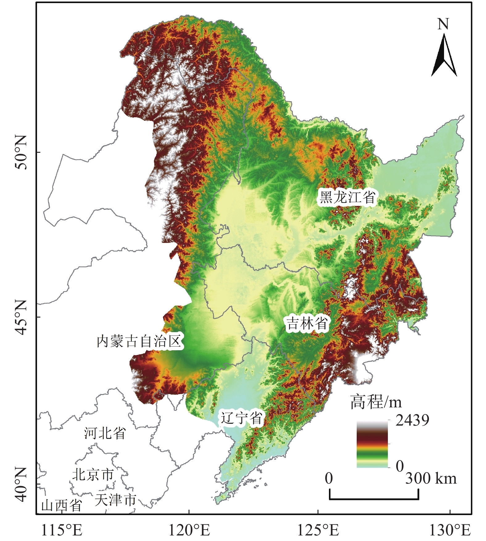
图 1 东北平原林耕资源大区高程(基于自然资源部标准地图服务网站审图号:GS(2019)1823的标准地图绘制,底图边界无修改,后图同)
Figure 1. Northeast Plain forest-farming resources area elevation
![]()
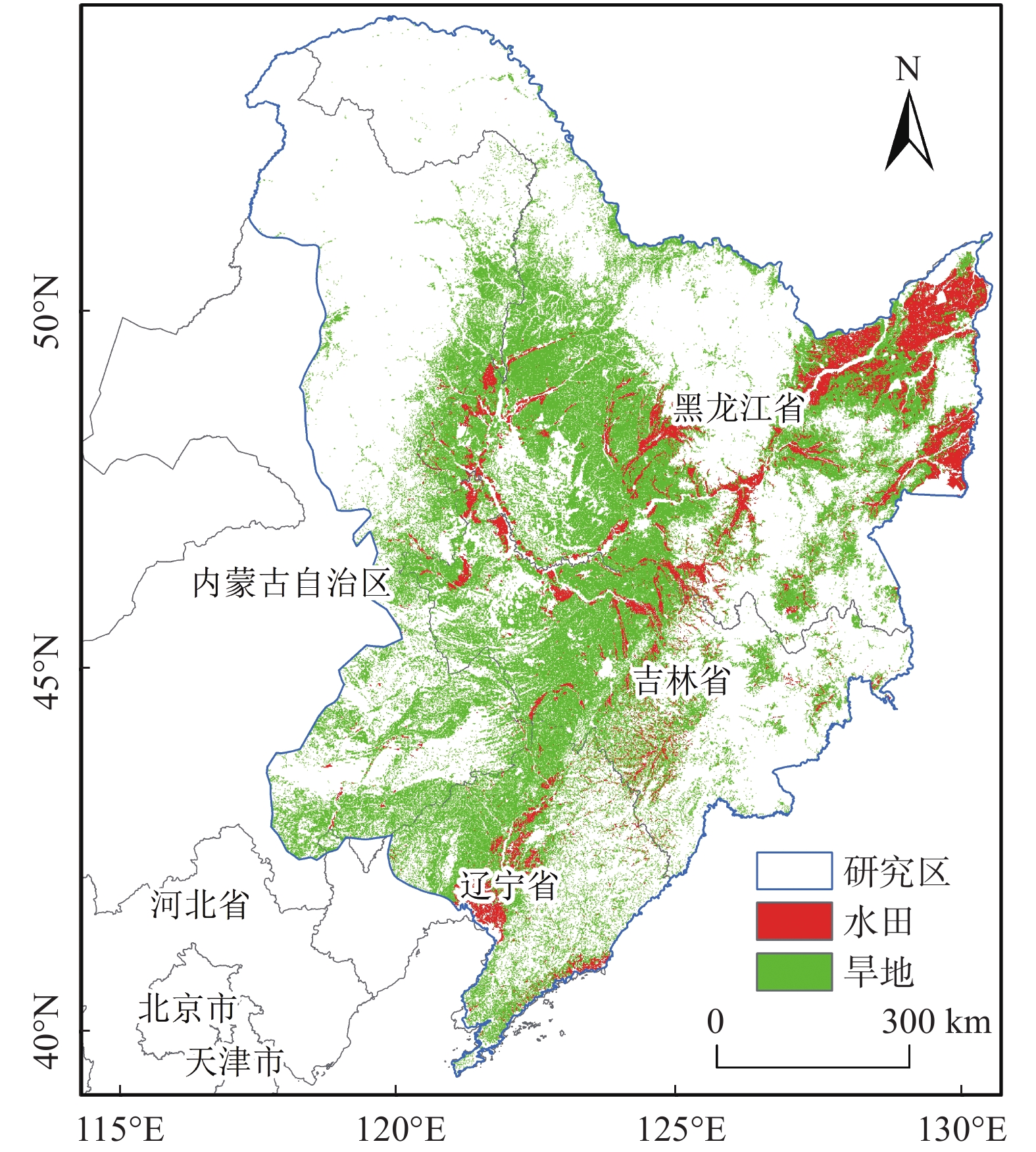
图 2 东北平原林耕资源大区水田与旱地分布
Figure 2. Distribution of paddy field and dry land in the forest-farming resources area of Northeast Plain
![]()
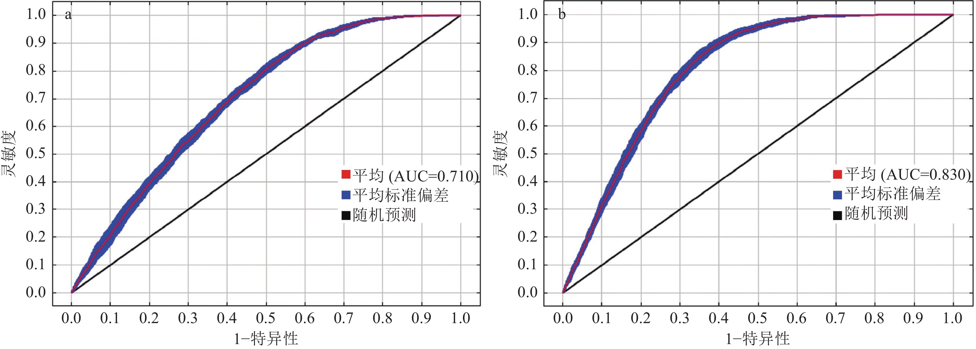
图 3 东北平原林耕资源大区耕地适宜区分布模型的受试者特征曲线(ROC)和曲线下面积(AUC)
a—旱地;b—水田
Figure 3. Receiver operating characteristic curve (ROC) and area under the ROC curve (AUC) of the suitable area distribution model of cultivated land in the Northeast Plain forest-farming resources area
![]()
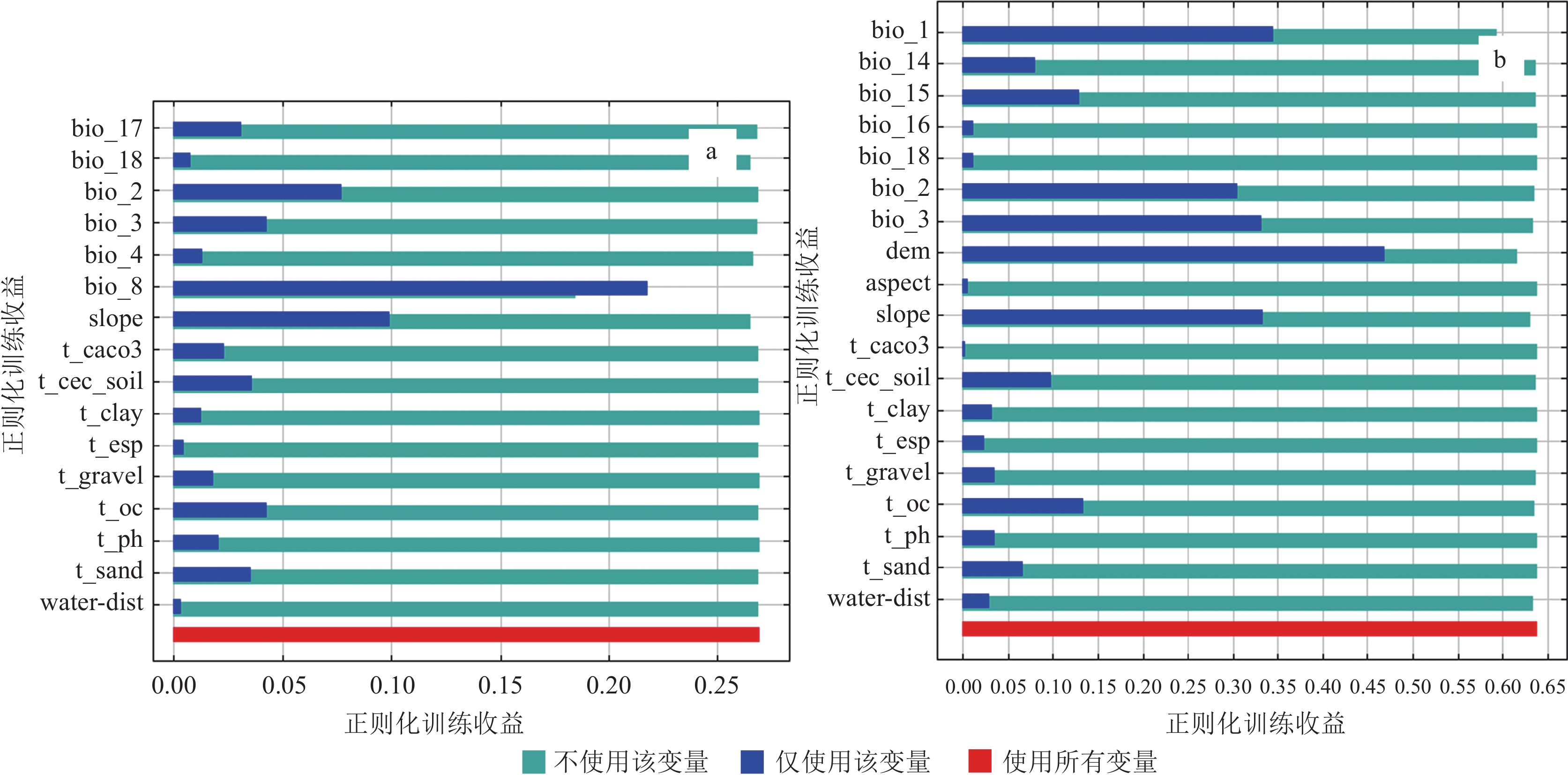
图 4 东北平原林耕资源大区旱地(a)和水田(b)适宜性的刀切检验结果
Figure 4. The results of the cut-and-cut test on the suitability of dry land (a) and paddy field (b) in the forest-farming resources area of the Northeast Plain
![]()
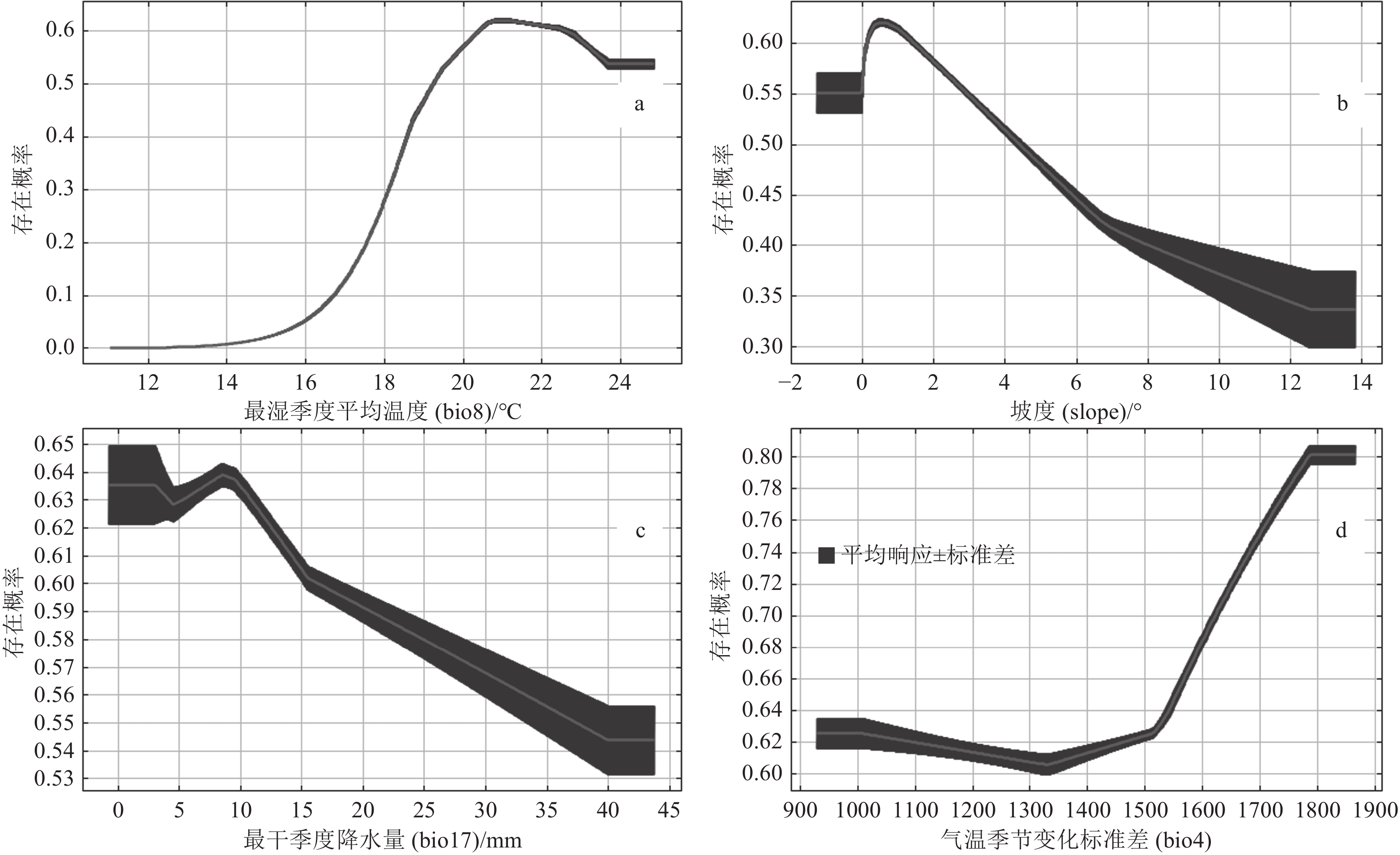
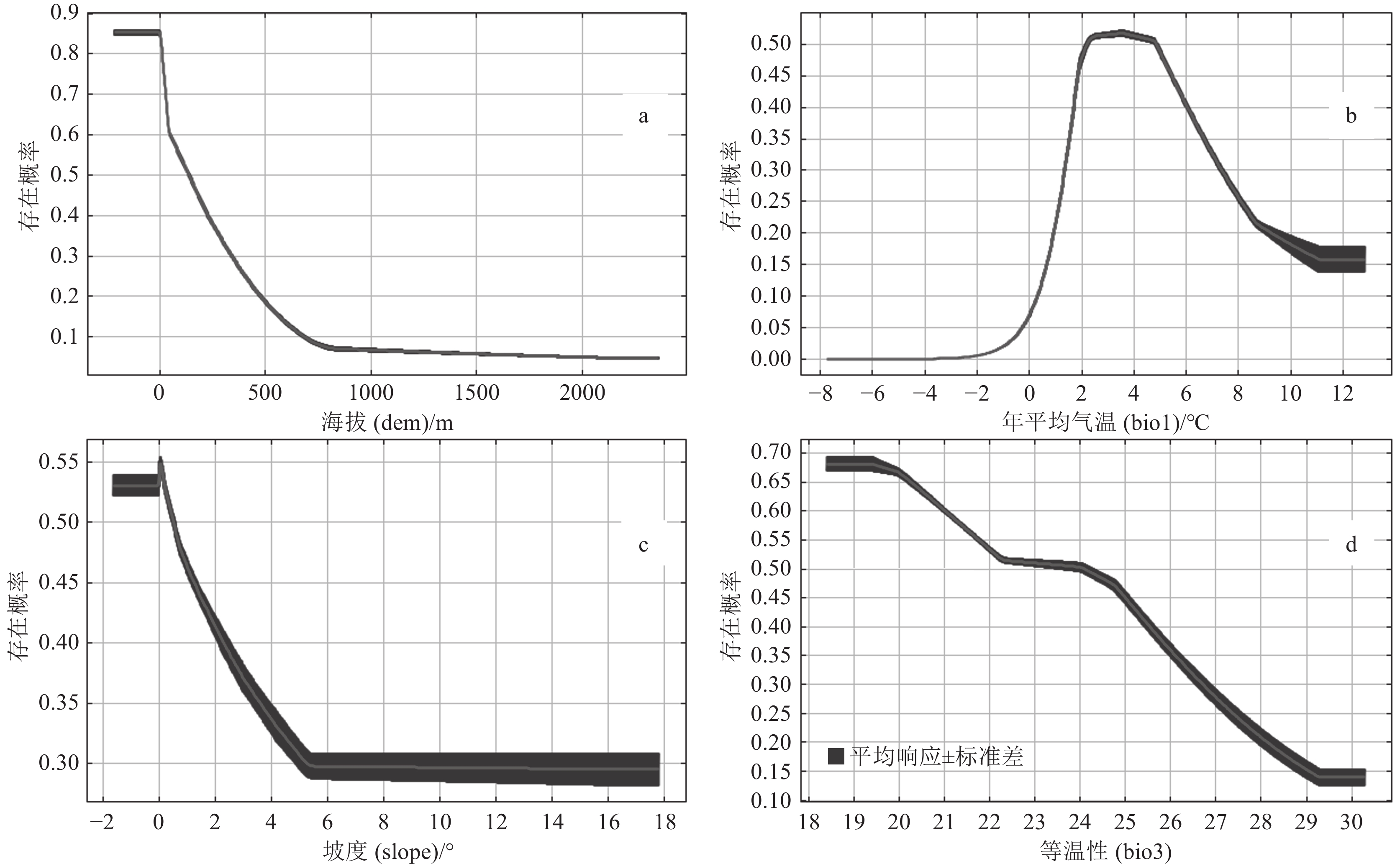
图 5 东北平原林耕资源大区旱地适宜性主要影响因素的响应曲线
a—最湿季度平均温度(bio8)与旱地适宜性的响应曲线;b—坡度(slope)与旱地适宜性的响应曲线;c—最干季度降水量(bio17)与旱地适宜性的响应曲线;d—气温季节变化标准差(bio4)与旱地适宜性的响应曲线
Figure 5. The response curve of the main factors affecting the suitability of dry land in the Northeast Plain forest-farming resources area
![]()
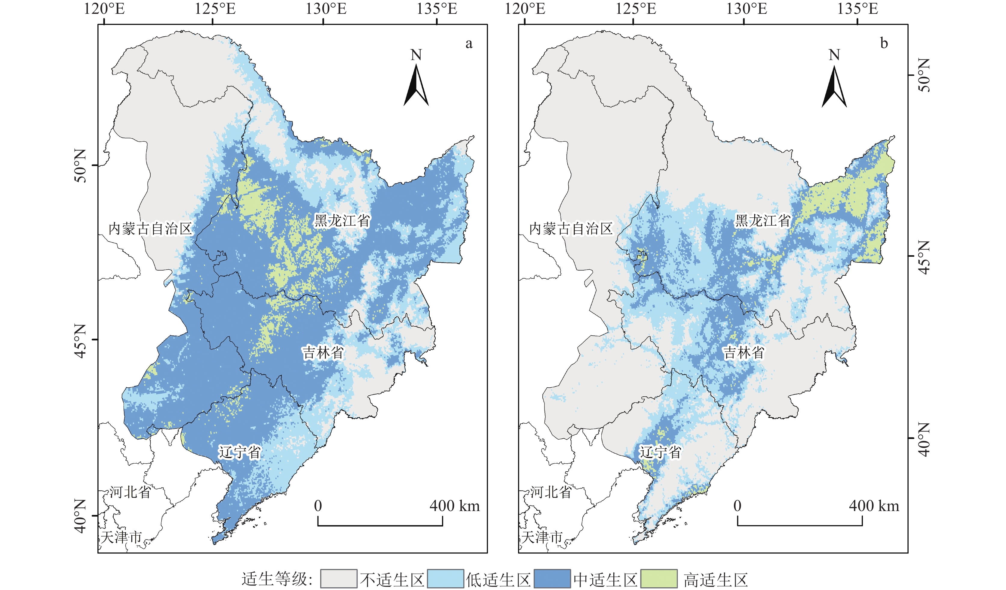
图 6 东北平原林耕资源大区旱地(a)和水田(b)适宜区分布
Figure 6. The distribution of dry land (a) and paddy (b) field suitable area in the Northeast Plain forest-farming resources area
![]()
图 7 东北平原林耕资源大区水田适宜性主要影响因素的响应曲线
a—海拔(dem)与水田适宜性的响应曲线;b—年平均气温(bio1)与水田适宜性的响应曲线;c—坡度(slope)与水田适宜性的响应曲线;d—等温性(bio3)与水田适宜性的响应曲线
Figure 7. The response curve of the main factors affecting the suitability of paddy field in the Northeast Plain forest-farming resources area
![]()
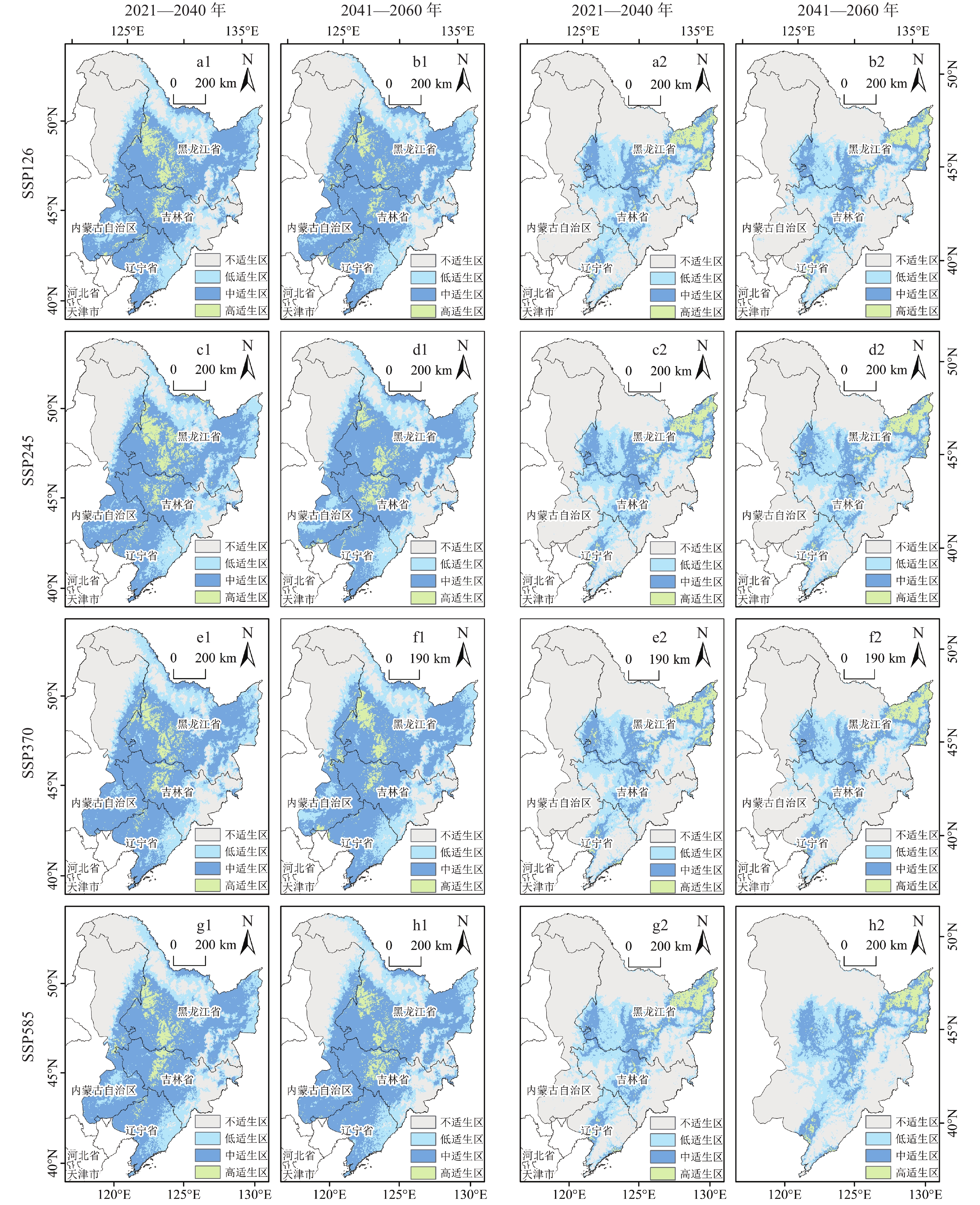
图 8 SSP126、SSP245、SSP370和SSP585情景下在未来近期和未来中期旱地(a1、b1、c1、d1、e1、f1、g1、h1)和水田(a2、b2、c2、d2、e2、f2、g2、h2)的潜在适生区预测
Figure 8. Prediction of potential suitable areas of SSP126, SSP245, SSP370 and SSP585 scenarios in dry land ( a1, b1, c1, d1, e1, f1, g1, h1 ) and paddy fields ( a2, b2, c2, d2, e2, f2, g2, h2 ) in the early future and mid future
表 1 水田与旱地特征
Table 1 Paddy field and dry land characteristics
耕地类型 描述 面积/km2 用于模型的栅格点数/个 旱地 无灌溉水源及设施,靠天然降水生长作物的耕地;有水源和浇灌设施,在一般年景下能正常灌溉的旱作物耕地;以仲裁为主的耕地;正常耕作的休闲地和轮歇地 292127 7143 水田 有水源保证和灌溉设施,在一般年景能正常灌溉,用以种植水稻、莲藕等水生农作物的耕地,包括实行水稻和旱地作物轮种的耕地 60739 3980  下载: 导出CSV
表 2 用于分析东北平原林耕资源大区耕地适宜区的31个环境变量及数据来源
Table 2 Thirty-one environmental variables and data sources used to analyze the suitable area of cultivated land in the Northeast Plain forest-farming resources area
变量类型 变量 描述 数据来源 气候因子 bio1 年平均气温/℃ 世界气候数据库(www.worldclim.org)中1970—2000年和
2021—2100年的气候因子bio2 昼夜温差月均值/℃ bio3 等温性[(bio2/bio7)×100] bio4 气温季节变化标准差(标准差×100) bio5 最暖月份最高温度/℃ bio6 最冷月份最低温度/℃ bio7 气温年较差(bio5-bio6)/℃ bio8 最湿季度平均温度/℃ bio9 最干季度平均温度/℃ bio10 最暖季度平均温度/℃ bio11 最冷季度平均温度/℃ bio12 年降水量/mm bio13 最湿月份降水量/mm bio14 最干月份降水量/mm bio15 降水量季节性变化/mm bio16 最湿季度降水量/mm bio17 最干季度降水量/mm bio18 最暖季度降水量/mm bio19 最冷季度降水量/mm 地形因子 aspect 坡向/° 国家青藏高原科学数据中心(https://data.tpdc.ac.cn) dem 海拔/m slope 坡度/° 土壤因子 t_caco3 碳酸盐含量/% 北京大学城市与环境学院地理数据平台(http://geodata.pku.edu.cn) t_cec_soil 土壤阳离子交换能力/(cmol·kg−1) t_clay 粘粒含量/% t_esp 可交换钠盐/% t_gravel 砾石体积百分比/% t_oc 有机碳含量/% t_ph 酸碱度(l) t_sand 沙含量/% 水文类 water-dist 水系距离/m OpenStreetMap Data extract (https://www.openstreetmap.org)
下载: 导出CSV
表 3 去除空间相关性后的变量及贡献率
Table 3 Variables and their contribution rates after removing spatial correlation
旱地 水田 变量 贡献率/% 变量 贡献率/% bio8 79.8 dem 34.5 slope 6.7 bio1 23.1 bio17 4.9 slope 20.1 bio4 3 bio3 11.6 bio18 2 bio14 3.4 bio2 1 bio15 1.6 bio3 0.8 water-dist 1.2 t_sand 0.5 bio2 1.1 t_oc 0.4 bio16 0.8 t_cec_soil 0.2 bio18 0.6 t_caco3 0.2 t_oc 0.5 t_esp 0.1 t_clay 0.5 water-dist 0.1 t_ph 0.4 t_ph 0.1 t_cec_soil 0.3 t_clay 0.1 aspect 0.2 t_gravel 0.1 t_sand 0.1 - - t_gravel 0.1 - - t_esp 0.1 - - t_caco3 0.1 注:变量的详细描述见表2
下载: 导出CSV
表 4 旱地历史时期和未来时期各适宜区面积
Table 4 The area of suitable areas in the historical and future periods of dry lands
104km2 适宜区 历史时期 未来近期 未来中期 SSP126 SSP245 SSP370 SSP585 SSP126 SSP245 SSP370 SSP585 高适生区 5.39 5.26 5.79 4.55 4.67 3.93 4.05 4.44 4.10 中适生区 48.71 47.69 47.67 49.63 49.10 50.87 49.60 49.38 50.25 低适生区 19.82 20.87 22.35 20.62 19.94 19.90 20.44 19.93 20.39 不适生区 30.18 30.31 28.31 29.32 30.40 29.42 30.03 30.36 29.38
下载: 导出CSV
表 5 水田历史时期和未来时期各适宜区面积
Table 5 The area of suitable areas in the historical period and future period of paddy field
104km2 适宜区 历史时期 未来近期 未来中期 SSP126 SSP245 SSP370 SSP585 SSP126 SSP245 SSP370 SSP585 高适生区 4.06 4.09 4.00 3.99 4.02 4.02 4.01 3.86 3.77 中适生区 13.67 13.49 14.62 14.08 13.64 13.79 13.67 14.22 14.33 低适生区 20.22 19.86 19.49 19.72 20.10 19.89 20.03 20.33 20.18 不适生区 66.17 66.68 66.00 66.33 66.37 66.43 66.41 65.70 65.85
下载: 导出CSV
-
Bai S Y, Zhang S W, Bao Y, et al. 2003. Application of RS and GIS in land suitability evaluation——Given example of Wuchuan County[J]. Journal of Soil and Water Conservation, (6): 18−21, 26 (in Chinese with English abstract).
Chen M Y, Wang S C, Lu Q, et al. 2024. Habitat suitability evaluation and influencing factors of waterbirds in coastal zone around Bohai Sea[J]. Chinese Journal of Ecology, 43(4): 1152−1160 (in Chinese with English abstract).
Eyring V, Bony S, Meehl G A, et al. 2016. Overview of the Coupled Model Intercomparison Project Phase 6 (CMIP6) experimental design and organization[J]. Geoscientific Model Development, 9: 1937−1958. doi: 10.5194/gmd-9-1937-2016
Fu Y J, Liu X H, Sun X L, et. al. 2024. Spatial−temporal variation of ecosystem carbon storage driven by land use in the northwest inland desert resource region in the past 30 years[J]. Geological Bulletin of China, 43(2/3): 451−462 (in Chinese with English abstract).
Gao X X, Liu J, Huang Z H. 2022. The impact of climate change on the distribution of rare and endangered tree Firmiana kwangsiensis using the Maxent modeling[J]. Ecology and Evolution, 12(8): e9165. doi: 10.1002/ece3.9165
Haddad N M, Brudvig L A, Clobert J, et al. 2015. Habitat fragmentation and its lasting impact on Earth's ecosystems[J]. Science Advances, 1(2): e1500052. doi: 10.1126/sciadv.1500052
He Z S, Wang L J, Jiang L, et al. 2019. Effect of microenvironment on species distribution patterns in the regeneration layer of forest gaps and non−gaps in a subtropical natural forest, China[J]. Forests, 10(2): 90. doi: 10.3390/f10020090
Hu Y B, Zhang Q, Xiao G J, et al. 2022. Effect of soil carbon, nitrgen and phosphate contents on maize production in semi−arid regions of China[J]. Journal of Desert Research, 42: 261−273 (in Chinese with English abstract).
Jiang F M, Xu Z H, Wang J F, et al. 2022. Identification and zoning of complex ecological functions in territorial space: A case study of Huzhou City of Zhejiang Province[J]. Journal of Zhejiang University ( Agriculture and Life Science ), 48: 227−239 (in Chinese with English abstract).
Kiss O, Catry I, Avilés J M, et al. 2020. Past and future climate−driven shifts in the distribution of a warm−adapted bird species, the European Roller Coracias Garrulus[J]. Bird Study, 67: 143−159. doi: 10.1080/00063657.2020.1784842
Kumar S, Stohlgren T J, Chong G W. 2006. Spatial heterogeneity influences native and nonnative plant species richness[J]. Ecology, 87: 3186−3199. doi: 10.1890/0012-9658(2006)87[3186:SHINAN]2.0.CO;2
Li D Y, Zhang Y C. 2020. Soil organic carbon and its influencing factors[J]. Agricultural Sciences, 10: 803−810 (in Chinese with English abstract).
Li H Y, Liu X H, Zhao X F, et al. 2023a. Contrasting effects of tectonic faults on vegetation growth along the elevation gradient in tectonically active mountains[J]. Forests, 14(12): 2336. doi: 10.3390/f14122336
Li S, Wang Z S, Zhu Z X, et al. 2023b. Predicting the potential suitable distribution area of Emeia pseudosauteri in Zhejiang Province based on the MaxEnt model[J]. Scientific Reports, 13(1): 1806. doi: 10.1038/s41598-023-29009-w
Liu J J, Kuang W H, Zhang Z X, et al. 2014. Spatiotemporal characteristics, patterns and causes of land use changes in China since the late 1980s[J]. Acta Geographica Sinica, 69: 3−14 (in Chinese with English abstract).
Liu X H, Liu X J, Jiang D, et al. 2023. Chinese natural resource zoning from a global perspective[M]. Beijing: Science Press (in Chinese with English abstract).
Liu Y H, Liu L, Chen H, et al. 2024. Habitat suitability evaluation of sable (Martes zibellina) based on MaxEnt model in Beijicun National Nature Reserve, Heilongjiang Province, China[J]. Acta Ecologica Sinica, 44(2): 559−569 (in Chinese with English abstract).
Ma R M, Ban J, Wang Q, et al. 2022. Full−coverage 1 km daily ambient PM2.5 and O3 concentrations of China in 2005−2017 based on a multi−variable random forest model[J]. Earth System Science Data, 14: 943−954. doi: 10.5194/essd-14-943-2022
Miao X R, Li Z H, Wang M Y. 2023. Spatiotemporal changes of cultivated land use system resilience in the black soil region of Northeast China under food supply security: A case study of Qiqihar City[J]. Resource Science, 45: 1801−1816 (in Chinese with English abstract).
Miller R H, Masuoka P, Klein T A, et al. 2012. Ecological niche modeling to estimate the distribution of Japanese Encephalitis Virus in Asia[J]. Plos Neglected Tropical Diseases, 6(6): e1678. doi: 10.1371/journal.pntd.0001678
Phillips S J, Anderson R P, Schapire R E. 2006. Maximum entropy modeling of species geographic distributions[J]. Ecological Modelling, 190: 231−259.
Rong W W, Huang X, Niu P X, et al. 2023. Potentially suitable areas for traditional Chinese medicinal material Ephedra equisetina based on MaxEnt model[J]. Acta Ecologica Sinica, 43: 8631−8646 (in Chinese with English abstract).
Semwal D P, Pandey A, Gore P G, et al. 2021. Habitat prediction mapping using BioClim model for prioritizing germplasm collection and conservation of an aquatic cash crop 'makhana' (Euryale ferox Salisb.) in India[J]. Genetic Resources and Crop Evolution, 68: 3445−3456. doi: 10.1007/s10722-021-01265-7
Song M S, Yang M, Fang X H. 2019. Improved control charts based on maximum entropy and their evaluations[J]. Chinese Journal of Management Science, 27: 208−216 (in Chinese with English abstract).
Soilhi Z, Sayari N, Benalouache N, et al. 2022. Predicting current and future distributions of Mentha pulegium L. in Tunisia under climate change conditions, using the MaxEnt model[J]. Ecological Informatics, 68: 101533. doi: 10.1016/j.ecoinf.2021.101533
Sun J J, Jiang B, Zhu J R, et al. 2020. Prediction of potential suitable habitat and dominate environmental factors of sassafras tzumu in Zhejiang with MaxEnt Model[J]. Journal of Northeast Forestry University, 48: 1−6 (in Chinese with English abstract).
Tang G A. 2019. Digital elevation model of China (1KM)[DS]. A Big Earth Data Platform for Three Poles(in Chinese).
Wang F H, Zhang K G, Fang X Q, et al. 2024. Spatio−temporal changes and sustainable utilization strategies of cultivated land in China over the past 2000 years[J]. Geological Bulletin of China, 43(8): 1373−1383 (in Chinese with English abstract).
Wang G. 2021. Spatiotemporal multi−scale habitat selection of red−crowned crane in Yancheng coastal wetland and its influencing mechanism [D]. Master's thesis of Nanjing Normal University (in Chinese with English abstract).
Wei L, Ge T D, Zhu Z K, et al. 2021. Comparing carbon and nitrogen stocks in paddy and upland soils: Accumulation, stabilization mechanisms, and environmental drivers[J]. Geoderma, 398: 115121. doi: 10.1016/j.geoderma.2021.115121
Worthington T A, Zhang T J, Logue D R, et al. 2016. Landscape and flow metrics affecting the distribution of a federally−threatened fish: Improving management, model fit, and model transferability[J]. Ecological Modelling, 342: 1−18. doi: 10.1016/j.ecolmodel.2016.09.016
Xiong M Q, Li F J, Liu X H, et al. 2023. Characterization of ecosystem services and their trade−off and synergistic relationships under different land−use scenarios on the loess plateau[J]. Land, 12(12): 2087. doi: 10.3390/land12122087
Xiong D Y, Zhang L, Li G Q. 2023. MaxEnt − based multi − class classification of land use in remote sensing image interpretation[J]. Remote Sensing for Natural Resources, 35: 140−148 (in Chinese with English abstract).
Xiong M Q, Liu X H, Zhang X H, et al. 2024. Spatio−temporal variation of soil conservation in the upper reaches of the Tarim River Basin based on RUSLE model[J]. Geological Bulletin of China, 43(4): 641−650 (in Chinese with English abstract).
Xu L, Fan Y, Zheng J, et al. 2023. Impacts of climate change and human activity on the potential distribution of Aconitum leucostomum in China[J]. The Science of the total environment, 912: 168829.
Yang L W, Zhang Y Y, Yang Z, et al. 2024. Potential habitat analysis and future conservation strategies of Pére David's deer based on MaxEnt model[J]. Chinese Journal of Ecology, 1−17 [2024−08−26]. http://kns.cnki.net/kcms/detail/21.1148.Q.20240118.1433.002.html (in Chinese with English abstract).
Ying B K, Tian K, Guo H Y, et al. 2023. Predicting potential suitable habitats of Kandelia obovata in China under future climatic scenarios based on MaxEnt model[J]. Acta Ecologica Sinica, 44(1): 224−234 (in Chinese with English abstract).
Zhou Y C, Zhang Z X, Zhu B, et al. 2021. MaxEnt modeling based on CMIP6 models to project potential suitable zones for Cunninghamia lanceolata in China[J]. Forests, 12(6): 752. doi: 10.3390/f12060752
Zhang M Y, Wang K L, Liu H Y, et al. 2008. Heterogeneity of landscape pattern with elevation in karst area[J]. Chinese Journal of Ecology, (7): 1156−1160 (in Chinese with English abstract).
Zhang R, Du G M, Zhang S W. 2023. Spatiotemporal changes and the driving factors of cultivated landresources of the typical black soil region in Northeast China from 1986 to 2020[J]. Resources Science, 45(5): 939−950 (in Chinese with English abstract).
Zhang W L, Kolbe H, Zhang S L. 2020. Research Progress of SOC Functions and Transformation Mechanisms[J]. Scientia Agricultura Sinica, 53: 317−331 (in Chinese with English abstract).
Zhang X, Zhao Y C, Xie E Z, et al. 2020. Spatio−temporal change of soil organic carbon, progress and prospects[J]. Journal of Agro−Environment Science, 39: 673−679 (in Chinese with English abstract).
Zhang X Y, Wu W H, Liang Y M. 2024. Prediction of potential suitable distribution of shoot blight of larch(Neofusicoccum laricinum) in China[J]. Acta Ecologica Sinica, 44(7): 3027−3037 (in Chinese with English abstract).
Zhao Z Y, Tu J J, Liu J, et al. 2010. GlS based on the karst area of cultivated land suitability evaluation in order to Yunyang County of Chongqing as an example[J]. Journal of Agricultural Mechanization Research, 32: 10−12,17 (in Chinese with English abstract).
Zheng J L, Cai Y L, Guo X Y, et al. 2024. Study on land use change and carbon stock in northern Shanxi Province based on InVEST model[J]. Geological Bulletin of China, 43(1): 173−180 (in Chinese with English abstract).
Zheng Y, Hu Y C, Liu Y S, et al. 2005. Spatial analysis and optimal allocation of land resources based on lanosuitability evaluation in Shandong Province[J]. Transactions of the Chinese Society of Agricultural Engineering, (2): 60−65 (in Chinese with English abstract).
Zinke L. 2022. Irrigation efficiency for expanded croplands[J]. Nature Reviews Earth & Environment, 3: 617−617.
白淑英, 张树文, 宝音, 等. 2003. 遥感和GIS在土地适宜性评价研究中的应用——以呼和浩特武川县为例[J]. 水土保持学报, (6): 18−21,26. doi: 10.3321/j.issn:1009-2242.2003.06.005 陈梦缘, 汪生财, 路琦, 等. 2024. 环渤海海岸带水鸟栖息地适宜性评价及影响因素[J]. 生态学杂志, 43(4): 1152−1160. 付宇佳, 刘晓煌, 孙兴丽, 等. 2024. 近30年西北内陆荒漠资源大区土地利用驱动下生态系统碳储量时空变化[J]. 地质通报, 43(2/3): 451−462. 胡延斌, 张强, 肖国举, 等. 2022. 中国半干旱区农田土壤碳、氮、磷含量对玉米生产的影响[J]. 中国沙漠, 42: 261−273. 姜芳茗, 徐志红, 王建锋, 等. 2022. 国土空间复合生态功能识别与分区——以浙江省湖州市为例[J]. 浙江大学学报(农业与生命科学版), 48: 227−239. 李典友, 章玉成. 2020. 土壤有机碳及其影响因素[J]. 农业科学, 10: 803−810. 刘纪远, 匡文慧, 张增祥, 等. 2014. 20世纪80年代末以来中国土地利用变化的基本特征与空间格局[J]. 地理学报, 69: 3−14. doi: 10.11821/dlxb201401001 刘晓煌, 刘晓洁, 江东, 等. 2023. 全球视角下的中国自然资源区划[M]. 北京: 科学出版社. 刘艳华, 刘磊, 陈红, 等. 2024. 基于Maxent模型的北极村国家级自然保护区紫貂栖息地适宜性评价[J]. 生态学报, 44(2): 559−569. 苗欣然, 李泽红, 王梦媛. 2023. 粮食供应安全下东北黑土区耕地利用系统韧性时空演变——以齐齐哈尔市为例[J]. 资源科学, 45: 1801−1816. doi: 10.18402/resci.2023.09.08 荣文文, 黄祥, 牛攀新, 等. 2023. 基于最大熵模型的中药材木贼麻黄潜在适生区[J]. 生态学报, 43: 8631−8646. 宋明顺, 杨铭, 方兴华. 2019. 基于最大熵分布的控制图改进与评价研究[J]. 中国管理科学, 27: 208−216. 孙杰杰, 江波, 朱锦茹, 等. 2020. 应用生态位模型预测檫木在浙江省的潜在适生区与主导环境因子[J]. 东北林业大学学报, 48: 1−6. doi: 10.3969/j.issn.1000-5382.2020.04.001 汤国安. 2019. 中国数字高程图(1KM)[DS]. 时空三极环境大数据平台. 王发浩, 张凯歌, 方修琦, 等. 2024. 中国过去2000年耕地的时空变化及其可持续利用策略[J]. 地质通报, 43(8): 1373−1383. 王刚. 2021. 基于时空多尺度的盐城滨海湿地丹顶鹤栖息地选择及其影响机制研究[D]. 南京师范大学硕士学位论文. 熊东阳, 张林, 李国庆. 2023. 基于最大熵模型的遥感土地利用多分类研究[J]. 自然资源遥感, 35: 140−148. 熊茂秋, 刘晓煌, 张雪辉, 等. 2024. 基于RUSLE模型的塔里木河流域上游土壤保持时空变化研究[J]. 地质通报, 43(4): 641−650. 杨丽雯, 张渊媛, 杨峥, 等. 2024. 基于最大熵模型的麋鹿潜在栖息地分析与保护对策[J/OL]. 生态学杂志, 1−17 [2024−08−26]. http://kns.cnki.net/kcms/detail/21.1148.Q.20240118.1433.002.html. 应邦肯, 田阔, 郭浩宇, 等. 2023. 基于MaxEnt模型预测未来气候变化情境下红树秋茄(Kandelia obovata)在中国潜在适生区的变化[J]. 生态学报, 44(1): 224−234. 张明阳, 王克林, 刘会玉, 等. 2008. 喀斯特区域景观空间格局随高程的分异特征[J]. 生态学杂志, (7): 1156−1160. 张瑞, 杜国明, 张树文. 2023. 1986—2020年东北典型黑土区耕地资源时空变化及其驱动因素[J]. 资源科学, 45(5): 939−950. 张维理, Kolbe H, 张认连. 2020. 土壤有机碳作用及转化机制研究进展[J]. 中国农业科学, 53: 317−331. doi: 10.3864/j.issn.0578-1752.2020.02.007 张秀, 赵永存, 谢恩泽, 等. 2020. 土壤有机碳时空变化研究进展与展望[J]. 农业环境科学学报, 39: 673−679. doi: 10.11654/jaes.2020-0031 张秀芸, 伍文慧, 梁英梅. 2024. 落叶松枯梢病在中国的适生性[J]. 生态学报, 44(7): 3027−3037. 赵在友, 涂建军, 柳蛟, 等. 2010. 基于GIS的喀斯特地区耕地适宜性评价——以重庆市云阳县为例[J]. 农机化研究, 32: 10−12,17. doi: 10.3969/j.issn.1003-188X.2010.01.003 郑吉林, 蔡艳龙, 郭晓宇, 等. 2024. 基于InVEST模型的晋北土地利用变化与碳储量研究[J]. 地质通报, 43(1): 173−180. doi: 10.12097/gbc.2022.05.038 郑宇, 胡业翠, 刘彦随, 等. 2005. 山东省土地适宜性空间分析及其优化配置研究[J]. 农业工程学报, (2): 60−65. doi: 10.3321/j.issn:1002-6819.2005.02.014
计量
- 文章访问数: 5571
- HTML全文浏览量: 4237
- PDF下载量: 767
