Research on land-space ecological restoration zoning based on the types of Earth’s Critical Zone: A case study of Xixia County, Henan Province
-
摘要:
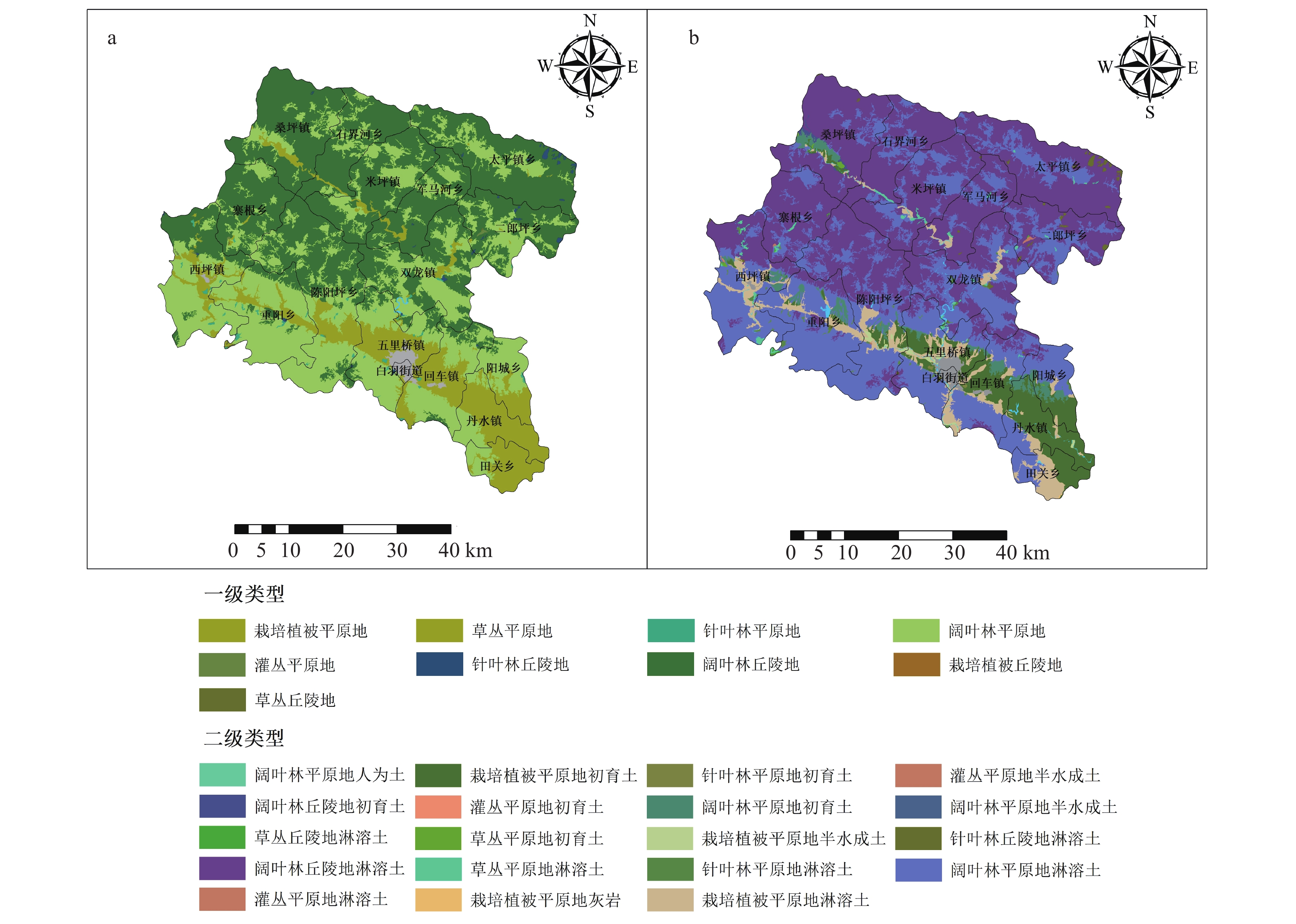
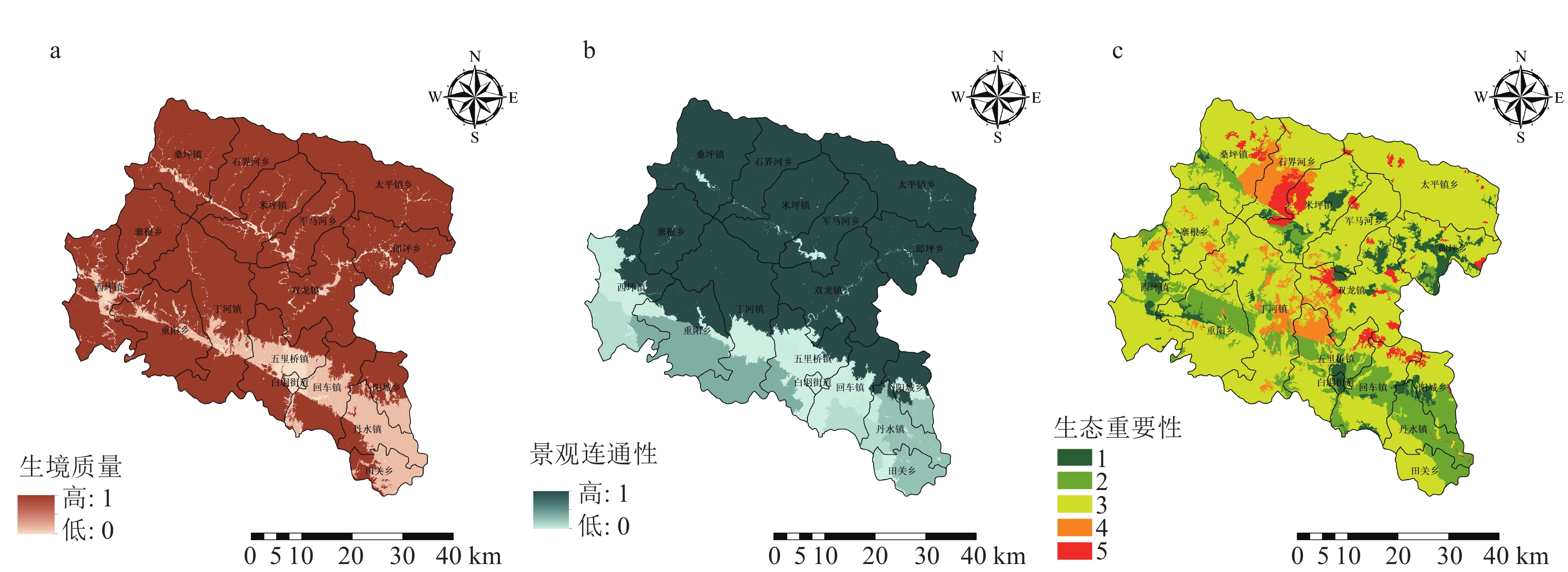
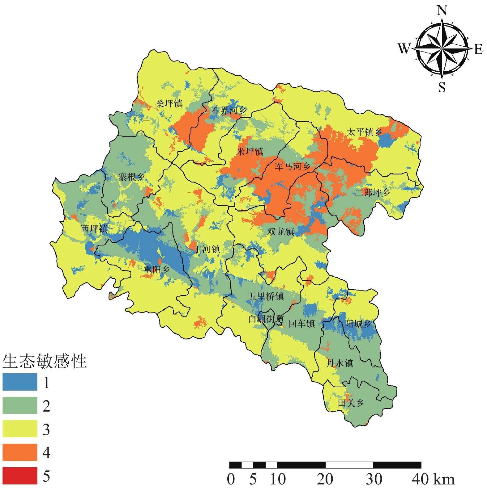
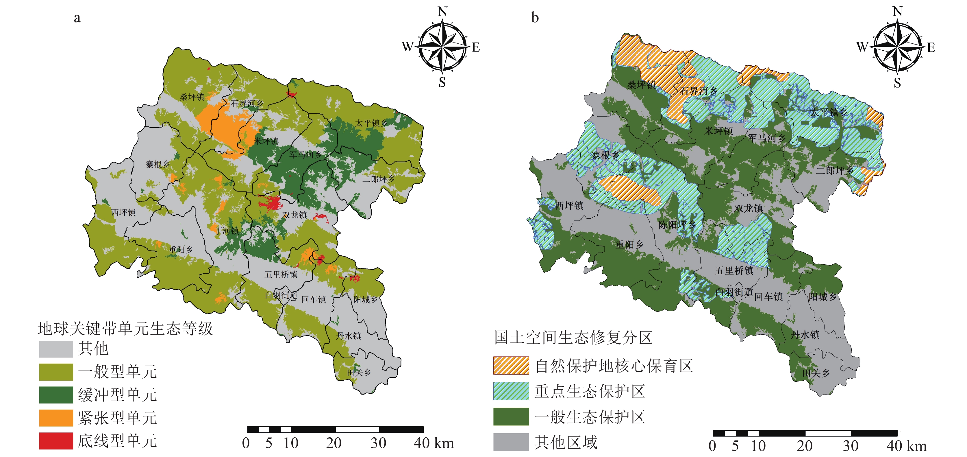
地球关键带类型单元反映自然本底特征,可为国土空间生态修复提供科学参考。以土地覆盖、地形、土壤为构成要素,划分县域地球关键带类型,并结合InVEST模型和Conefor2.6模型评估区域生态重要性和生态敏感性,识别县域国土空间生态修复分区。结果显示:①西峡县地球关键带类型可划分为一级类型8种,二级类型19种,一级类中阔叶林丘陵地类型为主要类型,二级类中阔叶林丘陵地淋溶土为主要类型;②高生态重要性等级地球关键带集中在中部和北部分布,约占县域的9.3%。生态敏感性等级高的地球关键带单元主要分布在北部丘陵区;③按生态等级将地球关键带单元分为底线型、紧张型、缓冲型和一般型4类,县域国土空间生态修复区域分为自然保护地核心保育区、重点生态保护区、一般生态保护区和其他区域。
Abstract:The type units of Earth’s Critical Zone reflect the characteristics of the natural background, which can provide scientific reference for the ecological restoration of land and space. We use land cover, topography and soil as the constituent elements to divide the types of Earth’s Critical Zone, the regional ecological importance and ecological sensitivity are evaluated by combining the InVEST model and Conefor2.6 model, and the land−space ecological restoration zone is identified. The results show that: ① The types of Earth’s Critical Zone in Xixia County could be divided into 8 first−class types and 19 second−class types, with the Broadleaf forest−Hilly in the first−class types as the main type, and the Broadleaf forest−Hilly−Leaching soil in the second−class types as the main type. ② The units of high ecological importance were concentrated in the central and northern parts, accounting for about 9.3% of the county. The units with high ecological sensitivity are mainly distributed in the northern hilly area. ③ According to the ecological level, the units of Earth’s Critical Zone are divided into four categories: bottom line, tension, buffer and general, and the ecological restoration is divided into core conservation area of nature reserve, key ecological reserve, general ecological reserve and other areas.
-
大别造山带不仅出露大面积的高压—超高压变质岩,而且发育大量的碰撞后岩浆岩(马昌前等,1999,2003;赵子福等,2009)。前人同位素年代学研究表明,大别造山带碰撞后岩浆活动高峰期为120~135 Ma(Xue et al., 1997;Hacker et al., 1998;薛怀民等,2002;赵子福等,2004;Xie et al., 2006;Wu et al., 2007;续海金等,2008)。这些燕山期的侵入岩以中酸性为主,同时还发育许多基性—超基性岩石。由于基性—超基性岩蕴含有大量的幔源信息,对这些岩石的研究,有助于了解大别造山带深部壳幔的地球化学特征及其相互作用。
从已有的资料看,前人对这些基性—超基性岩进行了一定的年代学和地球化学方面的研究(李曙光等,1997,1998,1999;陈道公等,1997,2001;聂永红等,1997;葛宁洁等,1999;王江海等,2002;王世明等,2010;Dai et al., 2011;谢清陆等,2016),但与同时期发育的中酸性岩相比,其研究程度明显不足。另外,前人的研究工作主要集中在北大别安徽段几个大的岩体,如椒子岩(陈道公等,1997;Zhao et al., 2005;李全忠等,2008)、沙村岩体(葛宁洁等,1999;赵子福等,2003;Zhao et al., 2005)等,对其他地方的基性—超基性岩报道较少。从近期工作看,在北大别湖北段也发育类似的基性—超基性岩,但野外特征上,相比于安徽段几个尚未发生变质变形的基性—超基性岩,湖北段基性—超基性岩发生了强烈的变质作用。这两类野外特征不同的基性—超基性岩,是否具相同的形成年龄和地球化学特征是需要查明的问题。对该问题的探讨,有助于对整个北大别地区基性—超基性岩的年代学研究和成因分析。
本文在1∶5万区域地质调查填图基础上,对北大别木子店地区的雷家湾辉长岩进行了岩石学、地球化学和年代学研究,并通过与安徽段基性—超基性岩研究成果进行对比,探讨了雷家湾辉长岩的岩石成因及其构造意义,为北大别地区晚中生代岩浆演化研究提供资料。
1. 地质背景及岩石学特征
大别造山带是三叠纪形成的碰撞造山带(徐树桐等,1992;徐树桐等,1994;杨巍然等,1999;汤加富等,2003;王勇生等,2004),先后经历了挤压作用、伸展作用、岩石圈减薄等多阶段作用过程(索书田等,2001;李曙光,2004;吴元保,2009;林伟等,2013;王清晨,2013;刘晓春等,2015)。大别造山带的东侧以郯庐断裂为界,西侧延伸可与秦岭造山带相连。碰撞后的伸展作用和晚燕山期以来的构造坍塌造就了大别造山带现今的构造样式。根据变质温度−压力条件,前人将该带划分为5个构造单元(Zheng et al., 2005),由北至南分别为北淮阳构造单元、北大别构造单元、超高压构造单元、高压构造单元和蓝闪−绿片岩构造单元。
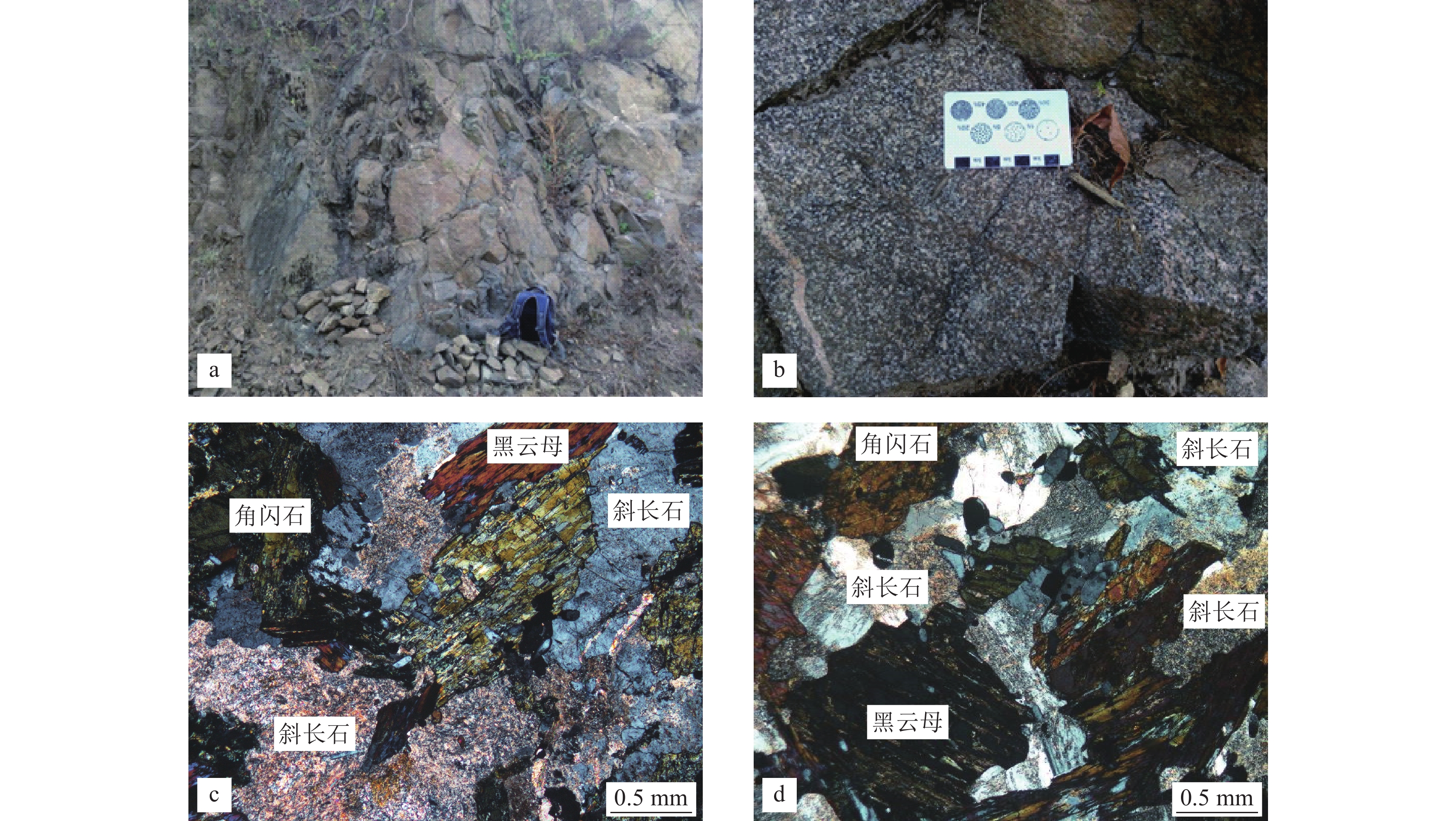
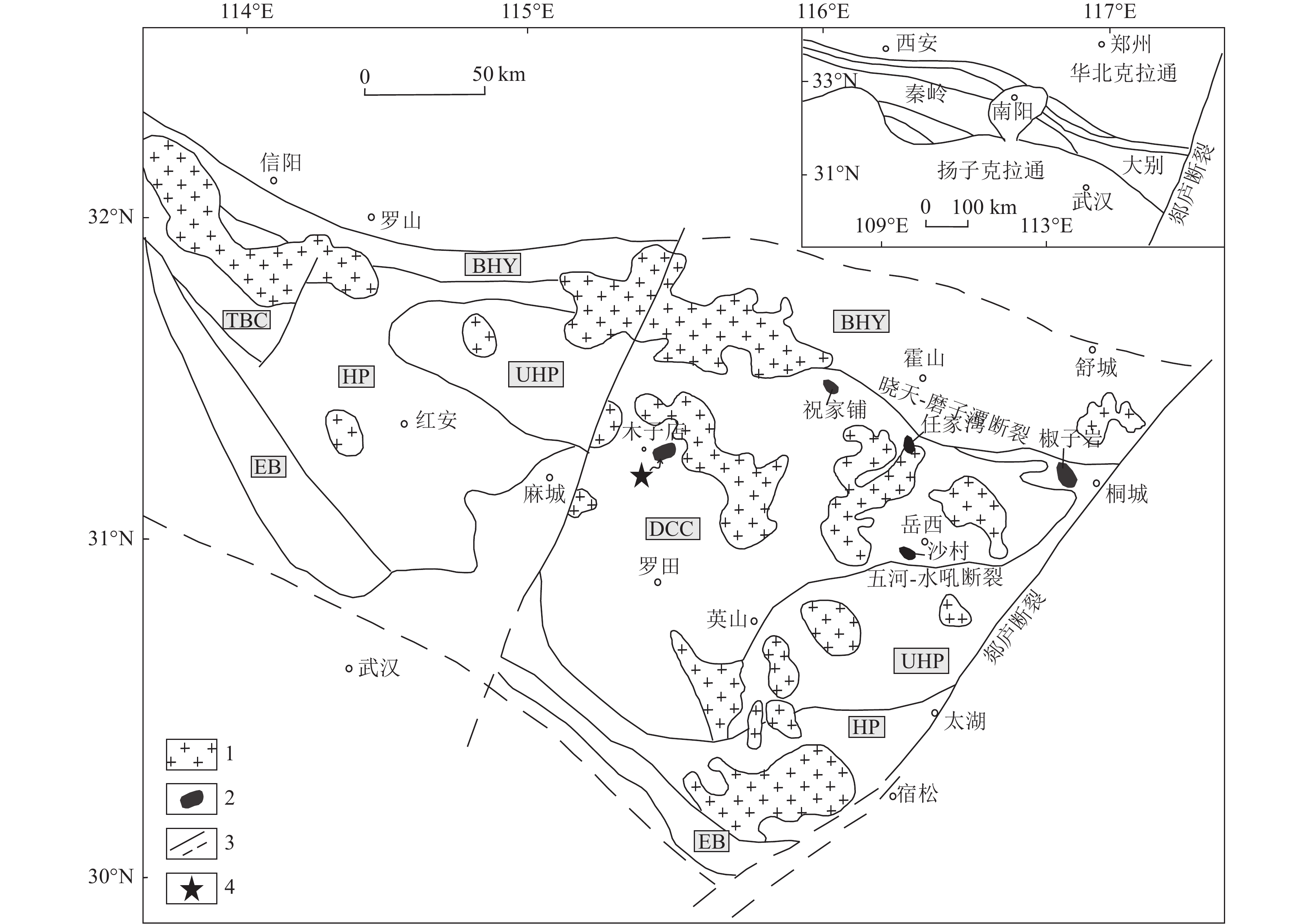
大别造山带发育较多的燕山期基性—超基性岩,从分布位置看,它们主要位于北大别构造单元内。野外以小型侵入体、团块状或脉状与围岩呈侵入接触关系。本次研究的雷家湾岩体位于麻城市木子店镇北东方向13 km处,处于北大别构造单元罗田穹隆核部位置(图1)。岩体近卵圆形,直径约2 km,与围岩二长花岗岩呈侵入接触。从岩体中心向边部,岩性由辉长岩逐渐过渡到闪长岩。野外特征上,雷家湾岩体发生强烈的变质,局部形成斜长角闪岩。本次采集的雷家湾辉长岩,呈灰绿色,半自形—自形柱状结构,块状构造(图2−a,b)。主要矿物有斜长石、辉石、角闪石、黑云母、石英等,少量副矿物为磁铁矿、磷灰石、榍石等。斜长石呈板柱状,晶体表面普遍布满粘土矿物集合体(图2−c),但仍可见聚片双晶;辉石呈半自形—他形,多蚀变为角闪石;角闪石呈黄绿色柱状,伴有透闪石化;黑云母全部被绿泥石和铁质集合体取代,具残余片状假象(图2−d);石英呈他形粒状分布于长石粒间。副矿物磁铁矿多呈包体分布于主要矿物晶体内,磷灰石多呈包体较集中分布于暗色矿物晶体内,榍石呈楔形与磁铁矿伴生。
2. 样品分析方法
选取1个辉长岩样品(采样位置: 北纬31°14′28″、东经115°29′41″) 的锆石用于LA−ICP−MS U−Pb年龄分析,针对7个辉长岩样品进行了岩石全分析。
野外采集约25 kg的辉长岩样品,采用常规方法进行粉碎,经淘洗、电磁分选等步骤后分离出锆石﹐在双目镜下挑选锆石颗粒,将其粘在环氧树脂上进行制靶﹐用阴极发光(CL)照相确定锆石颗粒内部结构,便于后期进行锆石U−Pb同位素测定。锆石阴极发光CL照相在JSM6510扫描电镜上完成。
锆石的U−Pb年龄测定由中国地质调查局武汉地质调查中心实验室完成。锆石LA−ICP−MS定年采用的仪器型号为icapQ型,配备有 RESOlution 193 nm ArF 准分子激光剥蚀系统,束斑直径为29 μm,频率为6~8 Hz。采用标准锆石91500校正U−Pb同位素,NIST SRM612校正元素含量。单个数据点误差为1σ。采用ICPMSDataCal软件(ver.10.9)对同位素组成数据进行处理(Liu et al., 2008)。采用Isoplot程序计算锆石年龄加权平均值和谐和图的绘制(Ludwig, 2003)。
主量、微量元素测试在自然资源部中南矿产资源监督检测中心完成。主量元素采用波长色散X荧光光谱仪分析,型号为荷兰PW2440,误差优于3.2%;微量元素分析仪器为法国JY38S型光谱仪,误差优于4% 。
3. 分析结果
3.1 锆石U−Pb 年龄
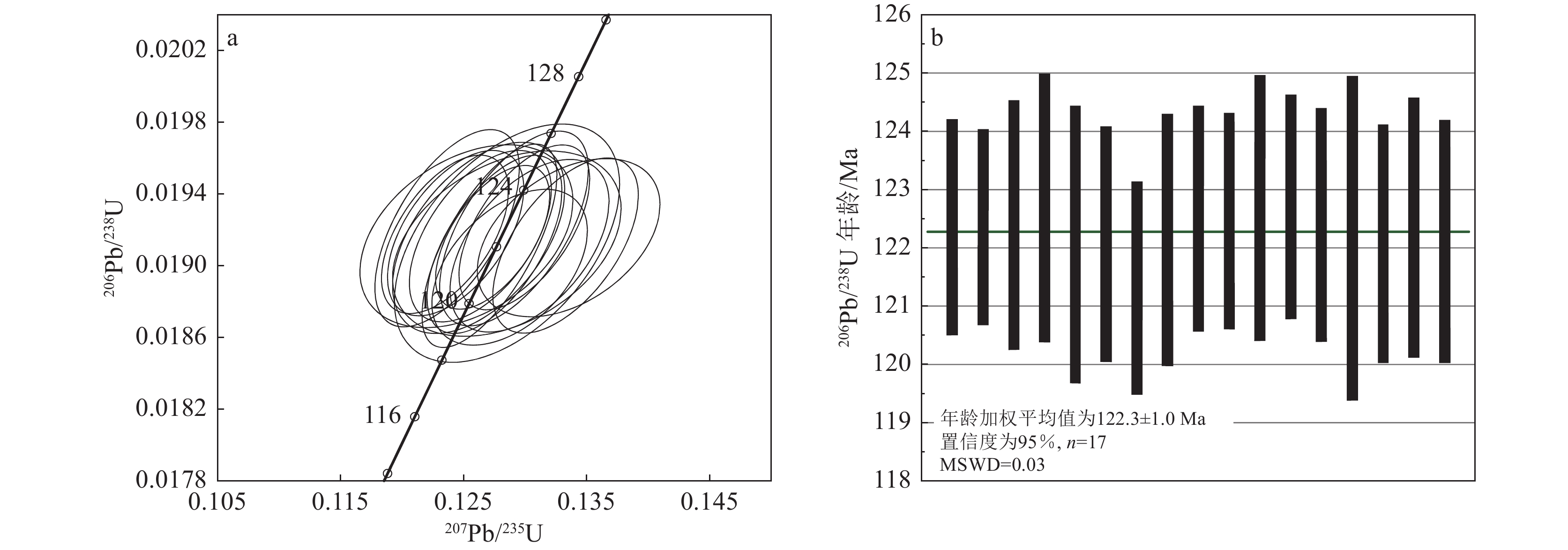
对雷家湾辉长岩样品中17颗锆石进行了LA−ICP−MS定年测试,每颗锆石测试一个点,其同位素分析结果见表1。样品锆石呈无色、浅粉色,透明—半透明,晶形为半自形—他形。锆石晶体粗大,通常在150~200 μm之间,个别可达300 μm,虽然部分碎裂,但总体仍保留了较好的晶形,大部分晶体显示较好的振荡环带(图3)。锆石Th含量为72×10−6~1734×10−6,平均值804×10−6;U含量为97×10−6~596×10−6,平均值288×10−6;Th/U值较高,平均为2.61。这些特征表明,该锆石为辉长岩中典型的岩浆锆石。从本次测试的同位素数据看,17颗锆石点较集中,206Pb/238U年龄介于121.3±1.8~122.7±2.3 Ma之间(图4),其年龄加权平均值为122.3±1.0 Ma(MSWD=0.03,置信度为95%),代表辉长岩的结晶年龄。
表 1 雷家湾辉长岩LA−ICP−MS锆石U−Th−Pb同位素分析结果Table 1. Result of zircon LA−ICP−MS U−Th−Pb dating for the Leijiawan gabbro分析号 含量/10−6 232Th/
238U同位素比值 同位素年龄/Ma 谐和度 Total
Pb232Th 238U 207Pb/
206Pb1σ 207Pb/
235U1σ 206Pb/
238U1σ 207Pb/
206Pb1σ 207Pb/
235U1σ 206Pb/
238U1σ LJW-1-1 19.9 532 192 2.77 0.05060 0.0018 0.1335 0.0049 0.01916 0.00029 233.4 81.5 127.2 4.4 122.4 1.8 96% LJW-1-2 36.0 1082 451 2.40 0.04833 0.0011 0.1273 0.0031 0.01916 0.00026 122.3 53.7 121.7 2.8 122.4 1.7 99% LJW-1-3 8.9 236 139 1.70 0.04718 0.0019 0.1252 0.0057 0.01917 0.00034 57.5 92.6 119.7 5.2 122.4 2.1 97% LJW-1-4 22.5 654 211 3.10 0.04714 0.0016 0.1236 0.0039 0.01921 0.00036 57.5 74.1 118.4 3.5 122.7 2.3 96% LJW-1-5 50.0 1576 596 2.64 0.04815 0.0010 0.1271 0.0036 0.01911 0.00037 105.6 48.1 121.4 3.3 122.1 2.4 99% LJW-1-6 28.3 829 254 3.26 0.04949 0.0015 0.1303 0.0043 0.01912 0.00032 172.3 70.4 124.4 3.8 122.1 2.0 98% LJW-1-8 31.3 1014 274 3.70 0.04913 0.0015 0.1287 0.0042 0.01900 0.00029 153.8 76.8 122.9 3.8 121.3 1.8 98% LJW-1-10 6.4 72 129 0.56 0.04880 0.0023 0.1285 0.0061 0.01913 0.00034 200.1 104.6 122.7 5.5 122.1 2.2 99% LJW-1-11 30.1 937 359 2.61 0.04691 0.0012 0.1243 0.0036 0.01918 0.00030 42.7 63.0 119.0 3.3 122.5 1.9 97% LJW-1-12 53.3 1734 422 4.11 0.04685 0.0013 0.1235 0.0034 0.01918 0.00029 42.7 63.0 118.2 3.1 122.5 1.8 96% LJW-1-13 24.3 779 250 3.12 0.04875 0.0014 0.1291 0.0040 0.01921 0.00036 200.1 73.1 123.3 3.6 122.7 2.3 99% LJW-1-14 22.7 622 376 1.65 0.04901 0.0012 0.1299 0.0035 0.01922 0.00030 146.4 59.3 124.0 3.1 122.7 1.9 98% LJW-1-15 41.7 1316 362 3.63 0.04779 0.0013 0.1263 0.0038 0.01917 0.00031 100.1 58.3 120.8 3.4 122.4 2.0 98% LJW-1-16 4.7 85 97 0.88 0.04965 0.0024 0.1285 0.0060 0.01913 0.00044 189.0 119.4 122.7 5.4 122.2 2.8 99% LJW-1-18 24.9 778 230 3.38 0.05091 0.0015 0.1332 0.0039 0.01912 0.00032 235.3 66.7 127.0 3.5 122.1 2.0 96% LJW-1-19 14.2 385 225 1.71 0.04780 0.0016 0.1262 0.0046 0.01916 0.00035 100.1 77.8 120.7 4.2 122.4 2.2 98% LJW-1-20 31.5 1030 325 3.17 0.04847 0.0013 0.1275 0.0036 0.01912 0.00033 120.5 63.0 121.8 3.3 122.1 2.1 99% 3.2 主量元素
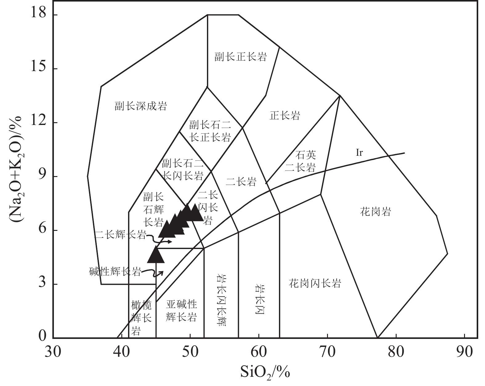
对雷家湾辉长岩7个样品进行了主量和微量元素分析,测试结果见表2。样品的烧失量为1.94%~4.12%,为了减少蚀变对岩石组分分析的影响,将烧失量扣除后,重新计算元素含量并归一至100%。岩石SiO2含量介于45.00%~50.69%之间,平均值为48.02%,属于基性岩范围。Al2O3含量介于11.88%~16.72%之间,平均值为15.42%。TFeO含量介于9.91%~15.64%之间,平均值为12.45%。MgO含量介于4.86%~8.44%之间,平均值为5.81%。TiO2含量介于1.61%~2.23%之间,平均值为1.79%。CaO含量介于6.64%~9.95%之间,平均值为8.16%。P2O5含量介于1.01%~1.50%之间,平均值为1.34%。K2O+ Na2O含量变化于4.68%~7.03%之间,平均值为6.31%,属于碱性系列。Mg#值变化范围在45.62~53.49之间,平均值为47.86,明显比原生岩浆的Mg#值低(60~71),暗示岩浆可能经历了结晶分异作用。在SiO2−(Na2O+K2O)图解(图5)中,所有样品点都落在碱性范围。
表 2 雷家湾辉长岩主量、微量和稀土元素分析结果Table 2. Major, trace and rare earth elements data for the Leijiawan gabbro样号 PM407/3-1 PM407/4-1 PM407/7-1 LJW-1 LJW-2 LJW-3 LJW-4 SiO2 48.13 43.20 49.12 46.71 46.58 45.37 47.38 TiO2 1.63 2.14 1.71 1.70 1.65 1.75 1.57 Al2O3 16.16 11.41 16.20 14.84 15.52 14.76 16.02 Fe2O3 4.68 6.20 3.34 5.11 5.06 5.77 4.88 FeO 6.87 9.44 6.60 7.63 7.53 7.98 7.06 TFeO 11.08 15.02 9.61 12.23 12.08 13.17 11.45 MnO 0.17 0.18 0.15 0.18 0.18 0.19 0.18 MgO 4.72 8.10 5.58 5.40 5.12 5.69 4.88 CaO 6.67 9.55 6.43 8.39 8.16 8.48 7.78 Na2O 3.55 1.64 3.56 2.89 3.05 2.79 3.18 K2O 3.28 2.85 3.23 3.21 3.24 3.14 3.30 P2O5 1.30 1.30 0.98 1.44 1.40 1.46 1.26 烧失量 3.21 4.12 3.88 1.94 2.20 2.20 2.14 总量 100.37 100.13 100.78 99.44 99.69 99.58 99.63 Mg# 45.75 51.64 53.49 46.65 45.62 46.10 45.76 La 115 69.6 93.6 108 109 88.1 122 Ce 222 152 182 218 212 180 236 Pr 26.3 18.6 21.6 26.5 25.2 22.0 26.2 Nd 103 77.0 83.6 107 101 89.7 104 Sm 17.1 14.0 13.5 18.3 16.9 15.7 17.0 Eu 4.26 3.44 3.28 4.46 4.28 3.93 4.26 Gd 13.6 11.2 11.0 14.6 13.6 12.4 14.3 Tb 1.70 1.39 1.37 1.83 1.67 1.53 1.69 Dy 7.70 6.58 6.24 8.38 7.56 6.91 7.62 Ho 1.31 1.12 1.08 1.43 1.34 1.14 1.31 Er 3.27 2.73 2.67 3.55 3.20 2.79 3.30 Tm 0.410 0.350 0.340 0.460 0.410 0.370 0.400 Yb 2.46 2.15 2.05 2.78 2.49 2.25 2.48 Lu 0.310 0.280 0.260 0.350 0.320 0.300 0.330 Y 31.1 27.9 25.6 34.9 31.4 27.6 33.2 ΣREE 518 360 423 516 499 427 541 LREE 488 335 398 482 468 399 509 HREE 30.8 25.8 25.0 33.4 30.6 27.7 31.4 LREE/HREE 15.9 13.0 15.9 14.4 15.3 14.4 16.2 LaN/YbN 33.5 23.2 32.8 27.9 31.4 28.1 35.3 δEu 0.854 0.840 0.823 0.834 0.863 0.861 0.835 Rb 63.5 79.8 78.4 74.7 76.6 82.2 70.0 Ba 4000 4320 3890 4460 4560 4950 4370 U 0.700 0.820 0.440 1.41 0.990 1.21 0.840 Th 8.03 5.54 6.08 8.29 7.54 8.62 9.34 Ta 0.570 0.480 0.730 0.650 0.630 0.780 0.580 Nb 14.7 10.3 20.8 13.7 13.1 13.4 13.0 Pb 11.2 9.8 11.8 12.1 12.9 12.5 12.4 Sr 1880 895 1420 1780 1960 1720 2050 Zr 154 99 212 154 214 217 196 Hf 4.14 3.23 4.80 3.98 4.89 4.99 4.50 注:TFeO=FeO+Fe2O3*0.8998;Mg#=100*MgO/[MgO+0.505*(FeO+0.9*Fe2O3)];δEu=Eu/Eu∗=2EuN/(SmN+GdN) ;主量元素含量单位为%,微量和稀土元素含量单位为10−6 3.3 稀土和微量元素
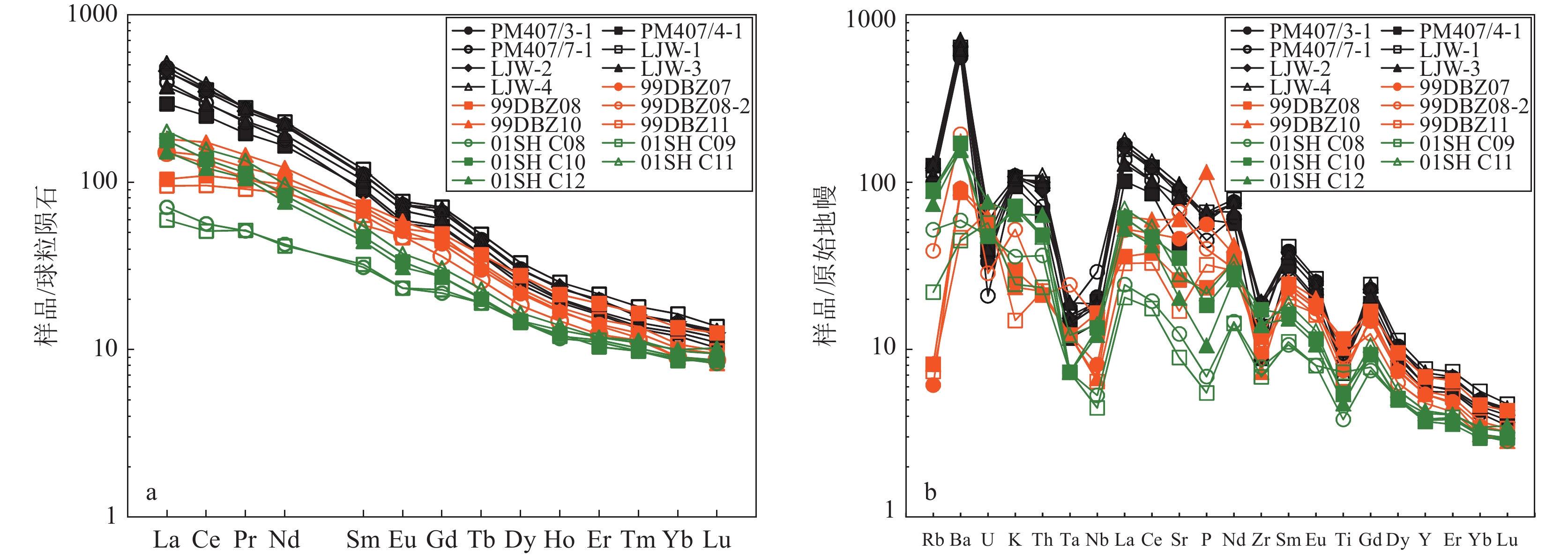
样品稀土、微量元素测试结果见表2。在稀土元素球粒陨石标准化配分模式图中,7个样品均表现出相同的稀土元素配分模式(图6−a)。样品稀土元素总量(∑REE)变化范围为360×10−6~541×10−6,平均值为469×10−6;其中轻稀土元素(LREE)平均含量为440×10−6,重稀土元素(HREE)平均含量为29.2×10⁻⁶;LREE/HREE值为13.0~16.2,(La/Yb)N值为23.2~35.3,δEu为0.823~0.863。雷家湾辉长岩强烈富集LREE,亏损HREE,轻、重稀土元素分馏明显;稀土元素配分曲线为右倾模式,其特点与碱性玄武岩相似。无或弱负Eu异常,指示早期没有或者很少有斜长石析出。微量元素蛛网图(图6−b)显示,雷家湾辉长岩总体富集Rb、Ba、K、Sr等大离子亲石元素(LILE),亏损高场强元素(HFSE)Ta、Nb、Zr、Ti等,与岛弧型火山岩具有相似的微量元素特征。
![]() 图 6 北大别不同地段基性—超基性岩稀土元素球粒陨石标准化配分图(a)和微量元素原始地幔标准化蛛网图(b)a—不同地段基性−超基性岩稀土元素球粒陨石标准化配分图;b—不同地段基性−超基性岩微量元素原始地幔标准化蛛网图;99DBZ—椒子岩数据(据李全忠等,2008);01SHC—沙村数据(据赵子福等,2003)Figure 6. Chondrite-normalized REE petterns (a) and trace element spider diagram (b) for mafic-ultramafic rocks in different regions of North Dabie
图 6 北大别不同地段基性—超基性岩稀土元素球粒陨石标准化配分图(a)和微量元素原始地幔标准化蛛网图(b)a—不同地段基性−超基性岩稀土元素球粒陨石标准化配分图;b—不同地段基性−超基性岩微量元素原始地幔标准化蛛网图;99DBZ—椒子岩数据(据李全忠等,2008);01SHC—沙村数据(据赵子福等,2003)Figure 6. Chondrite-normalized REE petterns (a) and trace element spider diagram (b) for mafic-ultramafic rocks in different regions of North Dabie4. 讨 论
4.1 北大别不同地段基性岩对比
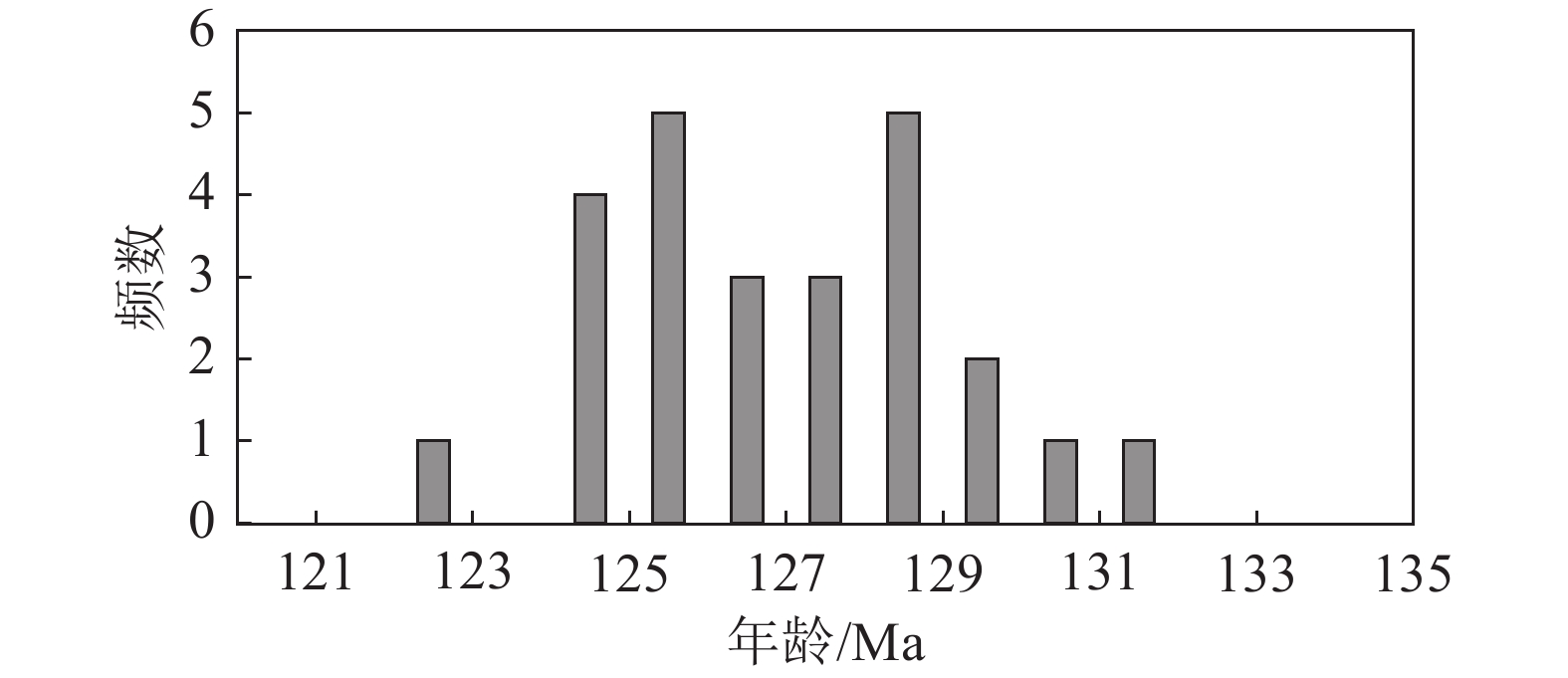
早期,由于测试手段和测试精度的不同,关于北大别中生代基性—超基性岩的形成时代有不同认识,主要分为印支期和燕山期(同碰撞和碰撞后)2种观点(李曙光等,1989,1997,1998,1999;Hacker et al., 1995,1998;陈道公等,1997,2001;聂永红等,1997,1998;Jahn et al.,1999;葛宁洁等,1999;Tsai et al., 2000)。随着近年来高精度锆石U−Pb同位素定年方法越来越普及,学者们对北大别基性—超基性岩的形成时代已初步达成共识,即主体侵位时间为130~120 Ma(Hacker et al., 1998;葛宁洁等,1999;李曙光等,1999;王江海等,2002;Wang et al., 2005;Zhao et al., 2005;王世明等,2010;Dai et al., 2011;Dai et al., 2012;谢清陆等,2016)。本次在北大别湖北段木子店地区采集的雷家湾辉长岩的结晶年龄为122.3±1.0 Ma,与北大别安徽段基性—超基性岩形成时代在误差范围内一致(表3;图7),进一步说明北大别不同地段的基性—超基性岩均形成于燕山期(碰撞后)。
表 3 大别造山带中生代基性—超基性岩年龄Table 3. Isotope age of the Mesozoic mafic-ultramafic rocks from Dabie Orogenic belt位置/岩体 岩性 年龄/Ma 定年方法 参考文献 小河口 闪长岩 127±6 TIMS锆石 李曙光等,1999 小河口 辉石岩 125.3±0.8 TIMS锆石 李曙光等,1999 祝家铺 闪长岩 130.2±1.4 TIMS锆石 李曙光等,1999 漆柱山 辉长岩 122.9±0.6 TIMS锆石 王江海等,2002 北大别 辉绿岩脉 128.3±0.1 全岩Ar−Ar Wang et al., 2005 北大别 煌斑岩 128.2±0.2 全岩Ar−Ar Wang et al., 2005 北大别 煌斑岩 129.6±0.2 全岩Ar−Ar Wang et al., 2005 北大别 辉绿岩脉 131.8±0.3 全岩Ar−Ar Wang et al., 2005 北大别 辉绿岩脉 127.6±0.2 全岩Ar−Ar Wang et al., 2005 沙村 辉长岩 128±2 TIMS锆石 Zhao et al., 2005 沙村 辉长岩 125±2 SHRIMP锆石 Zhao et al., 2005 沙村 辉长岩 125±3 SHRIMP锆石 Zhao et al., 2005 椒子岩 辉长岩 127±3 TIMS锆石 Zhao et al., 2005 金寨银沙畈 辉长岩脉 125.8±2.7 SHRIMP锆石 王世明等,2010 湖北大悟 闪斜煌斑岩脉 129.6±2.5 SHRIMP锆石 王世明等,2010 北淮阳 基性岩脉 129±1 SIMS锆石 Dai et al., 2011 道士冲 富斜长石角闪石岩 125±1 SIMS锆石 Dai et al., 2011 道士冲 富斜长石角闪石岩 129±1 LA−ICP−MS锆石 Dai et al., 2011 祝家铺 辉石岩 128±1 SIMS锆石 Dai et al., 2011 祝家铺 辉石岩 126±1 LA−ICP−MS锆石 Dai et al., 2011 祝家铺 富斜长石角闪石岩 126±2 SIMS锆石 Dai et al., 2011 祝家铺 富斜长石角闪石岩 126±1 LA−ICP−MS锆石 Dai et al., 2011 道士冲 角闪石岩 129±1 LA−ICP−MS锆石 Dai et al., 2012 祝家铺 角闪石岩 125±3 LA−ICP−MS锆石 Dai et al., 2012 道士冲 富斜长石角闪石岩 127±2 LA−ICP−MS锆石 Dai et al., 2012 祝家铺 角闪石岩 127±1 LA−ICP−MS锆石 Dai et al., 2012 ![]() 图 7 大别造山带中生代基性—超基性岩年龄频率图(资料来源见表3)Figure 7. Age spectrogram of the Mesozoic mafic-ultramafic rocks in the Dabie Orogenic belt
图 7 大别造山带中生代基性—超基性岩年龄频率图(资料来源见表3)Figure 7. Age spectrogram of the Mesozoic mafic-ultramafic rocks in the Dabie Orogenic belt从野外岩石特征看,雷家湾岩体从岩体中心向边部,岩性由辉长岩逐渐过渡到闪长岩,与安徽段基性—超基性岩具有相似的特征(葛宁洁等,1999;赵子福等,2003)。岩石化学方面,将2个地段的基性—超基性岩进行对比(图6)发现,二者具有相同的元素地球化学特征,均富集轻稀土元素和Rb、Ba、K、Sr等大离子亲石元素,明显亏损高场强元素(Ta、Nb、Zr、Ti等)和重稀土元素。
但值得注意的是,与前人研究的安徽段基性—超基性岩相比,雷家湾辉长岩具有更强的变质程度,其岩性为变质辉长岩,局部见斜长角闪岩,镜下具柱粒状变晶结构,且辉石多蚀变为角闪石。根据本次野外工作,结合前人研究成果,认为雷家湾辉长岩的变质作用可能与白垩纪岩浆后期热液的交代作用有关。至于同时代形成的、具有相同地球化学性质的基性—超基性岩,为何湖北段变质程度强于安徽段,可能与它们所处的构造部位有关:雷家湾岩体位于北大别构造单元罗田穹隆核部,因此受岩浆热和后期热液蚀变作用较强;而安徽段处于穹隆边部位置,岩石受到的热液交代作用较弱。
通过以上对比分析,北大别不同地段的基性—超基性岩具有相同的侵位时代,相似的岩相学和岩石化学特征,暗示它们具有相同的成因机制。
4.2 岩石成因
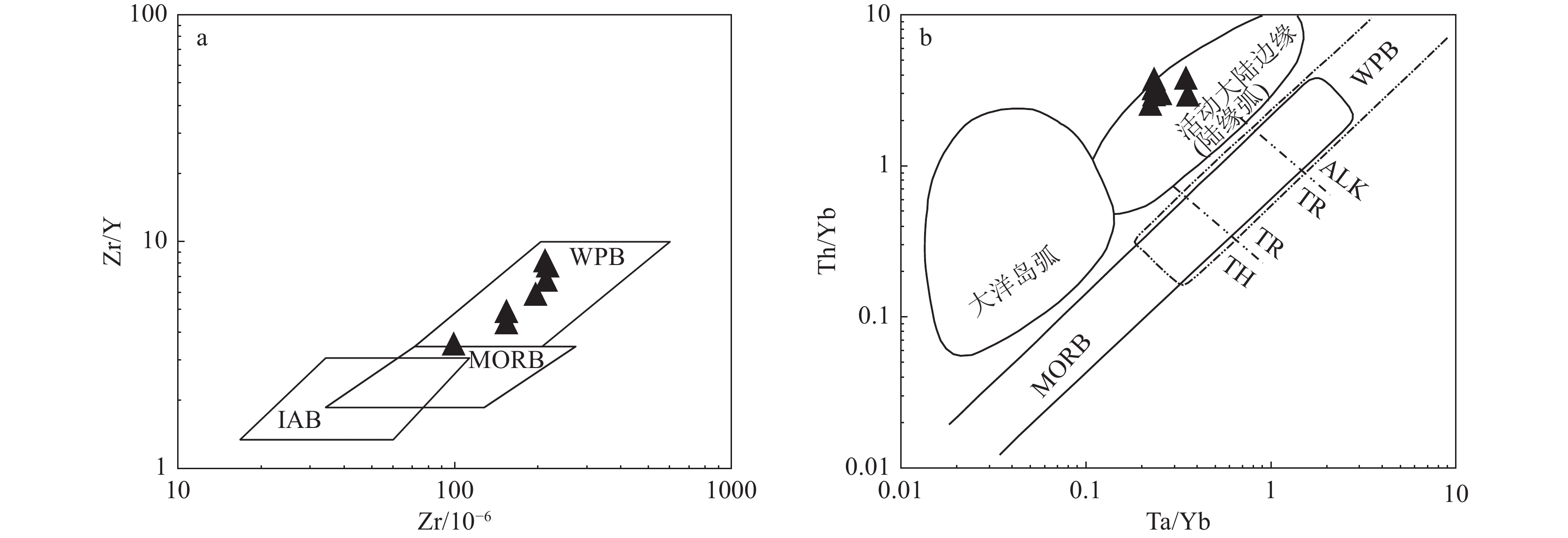
雷家湾辉长岩的SiO2含量低(45.00%~50.69%,平均值为48.02%),MgO含量较高(4.86%~8.44%,平均值为5.81%),表明其母岩浆来自于地幔。但是,部分地球化学特征反映其母岩浆具有地壳物质成分特点,如岩石明显富碱, K2O+ Na2O含量高,其值变化于4.68%~7.03%之间,平均值为6.31%;均富集轻稀土元素和Rb、Ba、K、Sr等大离子亲石元素,明显亏损高场强元素Ta、Nb、Zr、Ti等;在Zr−Zr/Y构造环境判别图(图8−a)上,样品显示板内玄武岩特征,而在Ta/Yb−Th/Yb构造环境判别图(图8−b)上,样品点位于活动大陆边缘弧范围,可能暗示其形成过程中有地壳物质加入。另外,前人的同位素研究表明,北大别基性—超基性岩具有高δ18O值(夏群科等,2002)、高87Sr/86Sr初始比值、低εNd(t)值等特征(Jahn et al., 1999;李曙光等,1999;陈道公等,2001;李全忠等,2008),说明幔源岩浆中有地壳物质的贡献。以上特征表明,雷家湾辉长岩的幔源母岩浆经历了地壳物质的加入。
地壳物质影响幔源岩浆主要通过以下2种方式:一种是源区的混合,即辉长岩母岩浆源区加入了地壳物质;另一种是母岩浆上升过程中遭受了地壳物质的混染。从雷家湾辉长岩的地球化学特征看,7个样品无论是微量元素蛛网图,还是稀土元素配分模式图都基本一致,说明其地球化学成分单一,岩浆上升过程中受到的地壳混染作用不明显;另外,从本次对雷家湾辉长岩锆石研究看,镜下显示没有熔蚀特征,也未见包体,且17颗锆石测试点年龄数据集中,没有发现古老残留锆石信息,说明未受到地壳物质的混染。因此认为,地壳物质对辉长岩幔源母岩浆的作用方式应该为源区的混合。
对于地壳物质加入到幔源母岩浆中的方式,本次研究认为可能与三叠纪以来扬子板块向华北板块俯冲后加厚岩石圈的拆沉作用有关。三叠纪,扬子板块向与华北板块俯冲,使大别造山带地壳加厚。但地球物理资料显示,目前大别造山带下部不存在山根,表明发生过岩石圈的拆沉作用;前人从岩石学、地球化学、地球物理等方面肯定了大别造山带岩石圈发生拆沉的可能性(高山等,1999;李超等,2002)。另一方面,大量研究表明,岩浆活动与岩石圈拆沉有密切关系(Sacks et al., 1990;Nelson, 1992;Kay et al., 1993),拆沉可使地壳抬升,并引发下地壳熔融,所以拆沉作用几乎与大规模的岩浆活动同时。综合以上特征,认为雷家湾辉长岩是由大别岩石圈地幔与拆沉的下地壳物质,在上涌的软流圈提供热源的条件下发生了部分熔融,形成具有富集特征的幔源母岩浆,于122 Ma左右上升侵位后形成。
4.3 构造意义
大别地区中生代以来,不仅有基性—超基性岩浆活动,更多的是发育大规模的中酸性岩。从大量年代学资料看,中酸性岩起始活动时间早,基性—超基岩晚,二者相差13 Ma左右,如目前大别地区报道的较老花岗岩的年龄为143±3 Ma和142±3 Ma(Wang et al.,2007),而基性—超基性岩的时代均不早于130 Ma(图7;表3)。马昌前等(2007)根据花岗岩的Sr/Y值,将花岗岩分为高Sr/Y和低Sr/Y值2种,并将时间限定在130 Ma,即高Sr/Y花岗岩的形成时代一般大于130 Ma,而低Sr/Y值花岗岩的形成时代一般小于130 Ma,因此将130 Ma视为造山带构造体制由挤压向伸展转换的时间,这与基性—超基性岩开始出现的时间吻合。基性—超基性岩的出现往往暗示岩石圈地幔物质熔融的开始,岩石圈地幔物质的熔融需要较高温度,而岩石圈拆沉导致的软流圈物质上涌能提供所需的热能。因此,笔者认为,大别地区中生代以来的岩浆活动是从下地壳的部分熔融开始的,于143 Ma左右形成时代较老的花岗质侵入体,直到130 Ma构造体制由挤压向伸展转换,引起加厚岩石圈发生垮塌,软流圈物质上涌;同时,由于早期下地壳部分熔融产生的熔体(早期的中酸性岩)被抽取后,富含石榴子石残留相物质的下地壳密度逐渐增大,也促进了加厚岩石圈物质拆沉进入软流圈。在上涌的软流圈物质提供热能的条件下,岩石圈地幔物质开始发生熔融,上升侵位后形成130 Ma以来的基性—超基性岩。
5. 结 论
(1)北大别木子店地区雷家湾辉长岩锆石U−Pb年龄为122.3±1.0 Ma,为早白垩世,与大别基性—超基性岩同期,是大别造山带碰撞后岩浆活动的重要组成部分。
(2)雷家湾辉长岩体与安徽段基性—超基性具有相似的野外特征,且地球化学特征均表现出富集大离子亲石元素Rb、Ba、K、Sr等和轻稀土元素,亏损高场强元素Ta、Nb、Zr、Ti等和重稀土元素,暗示二者具有相同的成因机制。
(3)雷家湾辉长岩的幔源母岩浆有地壳物质的加入,作用方式为源区的混合,地壳物质的加入可能与三叠纪以来扬子板块向华北板块俯冲后加厚岩石圈的拆沉作用有关。
(4)大别造山带中生代以来中酸性岩浆起始活动时间更早,基性—超基岩浆稍晚,130 Ma左右基性—超基性岩的出现可能暗示造山带构造体制由挤压向伸展转换。
致谢:LA−ICP−MS锆石U−Pb数据测试得到中国地质调查局武汉地质调查中心同位素地球化学研究室相关工作人员的帮助,野外期间得到中国地质大学(武汉)张欣、熊爱民协助,室内岩矿鉴定得到湖北省地质调查院邱玲教授级高工指导,稿件的修改得到两位审稿专家的指导,在此一并表示感谢。
-
表 1 地球关键带分类级别与命名规则
Table 1 Classification levels and naming rules for Earth's Critical Zone
级别 包含要素 理论单元种类 实际单元种类 命名举例 一级地球关键带 土地覆盖、地形 5×2 8 阔叶林丘陵地 二级地球关键带 土地覆盖、地形、土壤类型 5×2×5 19 阔叶林丘陵地淋溶土 表 2 威胁源参数设置
Table 2 Threat source parameter settings
威胁源 建设用地 耕地 裸地 草地 0.6 0.6 0.5 林地 0.7 0.5 0.5 园地 0.7 0.6 0.5 水域 0.7 0.4 0.3 权重 1 0.7 0.2 最大影响距离 0.8 0.5 0.3 表 3 水土流失敏感性影响因子分级
Table 3 Grading of erosion sensitivity impact factors
分级 不敏感(1) 轻度敏感(2) 中度敏感(3) 高度敏感(4) 极敏感(5) R值 <25 >600 400 ~ 600 100 ~ 400 25 ~ 100 土壤质地 石砾、沙 粗砂土、细砂土、粘土 面砂土、壤土 砂壤土、粉粘土、壤粘土 砂粉土、粉土 地形起伏度/m 0 ~ 20 20 ~ 50 50 ~ 100 100 ~ 300 300 ~ 450 沟谷密度/(km·km−2) <1 1 ~ 2 2 ~ 3 3 ~ 5 >5 植被类型 水体 阔叶林、针叶林 草丛 栽培植被 裸地 分级赋值(C) 1 3 5 7 9 表 4 地球关键带单元生态等级判别原则
Table 4 Discriminating principles of the ecological level of Earth's Critical Zone units
生态重要性等级
生态敏感性等级轻度重要 一般重要 中度重要 高度重要 极度重要 不敏感 其他单元 其他单元 其他单元 其他单元 其他单元 低敏感 其他单元 其他单元 其他单元 其他单元 其他单元 中敏感 其他单元 其他单元 一般型单元 缓冲型单元 紧张型单元 高敏感 其他单元 其他单元 缓冲型单元 紧张型单元 底线型单元 极敏感 其他单元 其他单元 紧张型单元 底线型单元 底线型单元 表 5 一级地球关键带类型数量结构
Table 5 Quantitative structure of first-class types of Earth’s Critical Zone
一级地球关键带类型 面积比 频率比 多样性指数 草丛平原地 0.51% 13.54% 0.000001 草丛丘陵地 0.03% 1.30% 0 灌丛平原地 0.07% 2.60% 0 阔叶林平原地 37.80% 33.59% 0.007182 阔叶林丘陵地 47.62% 18.75% 0.021154 栽培植被平原地 13.26% 8.07% 0.006164 针叶林平原地 0.36% 12.50% 0 针叶林丘陵地 0.34% 9.64% 0.000001 表 6 二级地球关键带类型数量结构
Table 6 Quantitative structure of second-class types of Earth’s Critical Zone
二级地球关键带类型 面积比 频率比 多样性指数 草丛平原地初育土 0.068% 2.08% 0 草丛平原地淋溶土 0.444% 11.46% 0.000001 草丛丘陵地淋溶土 0.033% 1.30% 0 灌丛平原地半水成土 0.007% 0.26% 0 灌丛平原地初育土 0.004% 0.26% 0 灌丛平原地淋溶土 0.060% 2.08% 0 阔叶林平原地半水成土 0.005% 0.26% 0 阔叶林平原地初育土 2.266% 4.17% 0.000074 阔叶林平原地淋溶土 35.521% 28.91% 0.007108 阔叶林平原地人为土 0.005% 0.26% 0 阔叶林丘陵地初育土 0.152% 0.78% 0.000001 阔叶林丘陵地淋溶土 47.470% 17.97% 0.021152 栽培植被平原地半水成土 0.293% 0.52% 0.000007 栽培植被平原地初育土 7.392% 2.34% 0.004952 栽培植被平原地淋溶土 5.572% 4.95% 0.001206 栽培植被平原地灰岩 0.007% 0.26% 0 针叶林平原地初育土 0.033% 1.30% 0 针叶林平原地淋溶土 0.326% 11.20% 0 针叶林丘陵地淋溶土 0.344% 9.64% 0.000001 表 7 各生态等级地球关键带类型
Table 7 Types of Earth's Critical Zone by ecological class
生态等级 一级地球关键带类型 二级地球关键带类型 一般型单元 栽培植被平原地 栽培植被平原地淋溶土 阔叶林平原地 阔叶林平原地淋溶土、阔叶林平原地初育土 针叶林平原地 针叶林平原地淋溶土、针叶林平原地初育土 草丛平原地 草丛平原地初育土、草丛平原地淋溶土 阔叶林丘陵地 阔叶林丘陵地淋溶土 针叶林丘陵地 针叶林丘陵地淋溶土 缓冲型单元 栽培植被平原地 栽培植被平原地初育土、栽培植被平原地淋溶土、栽培植被平原地灰岩 阔叶林平原地 阔叶林平原地淋溶土 针叶林平原地 针叶林平原地淋溶土 草丛平原地 草丛平原地淋溶土 阔叶林丘陵地 阔叶林丘陵地淋溶土 针叶林丘陵地 针叶林丘陵地淋溶土 紧张型单元 阔叶林平原地 阔叶林平原地淋溶土 针叶林平原地 针叶林平原地淋溶土 阔叶林丘陵地 阔叶林丘陵地淋溶土 针叶林丘陵地 针叶林丘陵地淋溶土 底线型单元 阔叶林平原地 阔叶林平原地淋溶土 针叶林平原地 针叶林平原地淋溶土 草丛平原地 草丛平原地淋溶土 阔叶林丘陵地 阔叶林丘陵地淋溶土 针叶林丘陵地 针叶林丘陵地淋溶土 -
Bushnell T M. 1943. Some aspects of the soil catena concept[J]. Soil Science Society of America Journal, 7(C): 466−476. doi: 10.2136/sssaj1943.036159950007000C0079x
Cui N, Yu E Y, Li S, et al. 2021. Protection measures of plateau lake based on ecosystem sensitivity and importance of ecosystem function: the case of Lake Dalinor Basin[J]. Acta Ecologica Sinica, 41(3): 949−958 (in Chinese with English abstract).
Ding G H. 2021. Research on identification and strategy of key areas of ecological protection and restoration based on circuit theory: A case of Xixia County, Henan Province[D]. Master's thesis, China University of Geosciences (Beijing) (in Chinese with English abstract).
Fridland V M. 1974. Structure of the soil mantle[J]. Geoderma, 12(1): 35−41.
Gao H. 2018. Land classification and division in Hunan Province[D]. Master's thesis, Hunan Agricultural University (in Chinese with English abstract).
Guo C H, Zhang M S, Wang Y, et al. 2023. Ecological restoration of China's territorial space in Yulin section of the Yellow River Basin through nature−based solutions[J]. Geological Bulletin of China, 42(10): 1745−1756(in Chinese with English abstract).
Kong L Q, Zheng H, Ouyang Z Y. 2019. Ecological protection and restoration of forest, wetland, grassland and cropland based on the perspective of ecosystem services: a case study in Dongting Lake Watershed[J]. Acta EcologicaSinica, 39(23): 8903−8910(in Chinese with English abstract).
Li X, Wu K N, Liu Y N, et al. 2019. Ecological protection and restoration of mountains−rivers−forests−farmlands−lakes−grasslands based onecosystem services−utilizing Heshan section of the south Taihang area as an example[J]. Acta EcologicaSinica, 39(23): 8806−8816(in Chinese with English abstract).
Li X L, Wu K N, Feng Z, et al. 2022. Research progress of land surface system classification: From land type to Earth's critical zone type[J]. Progress in Geography, 41(3): 531−540(in Chinese with English abstract). doi: 10.18306/dlkxjz.2022.03.015
Liu K, Kang Y, Cao M M, et al. 2004. GIS−based assessment on sensitivity to soil and water loss in Shaanxi Province[J]. Journal of Soil and Water Conservation, 18(5): 168−170(in Chinese with English abstract).
Liu S D, Liu L, Zhang J J, et al. 2019. Study on ecological protection and restoration path of arid area based on improvement of ecosystem service capability: A case of the ecological protection and restoration pilot project area in Irtysh River Basin[J]. Acta Ecologica Sinica, 39(23): 8998−9007 (in Chinese with English abstract).
Liu S L, Dong Y H, Sun Y X, et al. 2019. Priority area of mountains−rivers−forests−farmlands−lakes−grasslands based on the improvement of ecosystem services: A case study of Guizhou Province[J]. Acta EcologicaSinica, 39(23): 8957−8965(in Chinese with English abstract).
Liu Y N, Wu K N, Li X L, et al. 2021. Land−type classification at provincial level based on GIS and Fuzzy SOFM model: A case study of Henan Province[J]. China Land Science, 35(11): 112−122(in Chinese with English abstract).
Ministry of Natural Resources. 2020. Guidelines for ecological protection and restoration of mountains, waters, forests, fields, lakes and grasses (trial)[R].
Niu Z J. 2018. Study on the classification and structure analysis of land types in Laiyuan County[D]. Master's thesis, Hebei Agricultural University (in Chinese with English abstract).
Shen Y C, Li C W. 1983. A preliminary study on the structure of land types and agricultural natural regionalization: Based on the study of Beijing area[J]. Geographical Research, (4): 11−22 (in Chinese with English abstract).
Shen Y C. 2010. Studies on land types: Academic significance, function and prospect[J]. Geographical Research, 29(4): 575−583(in Chinese with English abstract).
Shi Y L. 1985. Main characteristics of China's mountains and their rational utilization[J]. Resources Science, (4): 1−7(in Chinese with English abstract).
Wang X Y, Feng Z, Wu K N, et al. 2019. Ecological conservation and restoration of life community theory based on the construction of ecological security pattern[J]. Acta EcologicaSinica, 39(23): 8725−8732 (in Chinese with English abstract).
Wu G, Zhao M, Wang C X. 2019. Research on the theoretical support system of ecological protection and restoration of full−array ecosystems[J]. Acta EcologicaSinica, 39(23): 8685−8691 (in Chinese with English abstract).
Wu K N, Zhao R. 2019. Soil texture classification and its application in China[J]. Acta PedologicaSinica, 56(1): 227−241(in Chinese with English abstract).
Yang S H, Zhang G L. 2021. What is the Critical Zone[J]. Science, 73(5): 4,33−36(in Chinese with English abstract).
Yu E Y, Qi L, Dai L M, et al. 2019. Correlation analysis of elements in the mountains−rivers−forests−farmlands−lakes−grasslands life community: using Changbai mountains as an example[J]. Acta EcologicaSinica, 39(23): 8837−8845(in Chinese with English abstract).
Zhang C, Fang S M. 2021. Identifying and zoning key areas of ecological restoration for territory in resource−based cities: A case study of Huangshi City, China[J]. Sustainability, 13(7): 3931. doi: 10.3390/su13073931
Zhang G L, Song X D, Wu K N. 2021. A classification scheme for Earth’s critical zones and its application in China[J]. Science China Earth Sciences, 64(10): 1709−1720(in Chinese with English abstract). doi: 10.1007/s11430-020-9798-2
Zhang H T, Li J L, Tian P, et al. 2022. Construction of ecological security patterns and ecological restoration zones in the city of Ningbo, China[J]. Journal of Geographical Sciences, 32(4): 663−681. doi: 10.1007/s11442-022-1966-9
Zhang X Y. 2021. Analysis and Evaluation of Sensitivity ofSoil Erosion in Bin Xian[D]. Master's thesis, Northeast Agricultural University (in Chinese with English abstract).
Zhou C H, Cheng W M, Qian J K. 2009. Research on the classification system of digital land geomorphology of 1: 1 000 000 in China[J]. Journal of Geo−information Science, 11(6): 707−724(in Chinese with English abstract).
崔宁, 于恩逸, 李爽, 等. 2021. 基于生态系统敏感性与生态功能重要性的高原湖泊分区保护研究——以达里湖流域为例[J]. 生态学报, 41(3): 949−958. 丁广辉. 2021. 基于电路理论的生态保护修复关键区域识别及策略研究[D]. 中国地质大学(北京)硕士学位论文. 高晗. 2018. 湖南省土地分类及分区研究[D]. 湖南农业大学硕士学位论文. 郭迟辉, 张茂省, 王尧, 等. 2023. 基于自然解决方案的黄河中游国土空间生态修复——以陕西榆林国土空间生态修复为例[J]. 地质通报, 42(10): 1745−1756. doi: 10.12097/j.issn.1671-2552.2023.10.011 孔令桥, 郑华, 欧阳志云. 2019. 基于生态系统服务视角的山水林田湖草生态保护与修复——以洞庭湖流域为例[J]. 生态学报, 39(23): 8903−8910. 李潇, 吴克宁, 刘亚男, 等. 2019. 基于生态系统服务的山水林田湖草生态保护修复研究——以南太行地区鹤山区为例[J]. 生态学报, 39(23): 8806−8816. 李晓亮, 吴克宁, 冯喆, 等. 2022. 陆地表层系统分类研究进展——从土地类型到地球关键带类型[J]. 地理科学进展, 41(3): 531−542. doi: 10.18306/dlkxjz.2022.03.015 刘康, 康艳, 曹明明, 等. 2004. 基于GIS的陕西省水土流失敏感性评 价[J]. 水土保持学报, (5): 168−170. doi: 10.3321/j.issn:1009-2242.2004.05.041 刘时栋, 刘琳, 张建军, 等. 2019. 基于生态系统服务能力提升的干旱区生态保护与修复研究——以额尔齐斯河流域生态保护与修复试点工程区为例[J]. 生态学报, 39(23): 8998−9007. 刘世梁, 董玉红, 孙永秀, 等. 2019. 基于生态系统服务提升的山水林 田湖草优先区分析——以贵州省为例[J]. 生态学报, 39(23): 8957−8965. 刘亚男, 吴克宁, 李晓亮, 等. 2021. 基于GIS和模糊SOFM模型的省级尺度土地类型划分研究——以河南省为例[J]. 中国土地科学, 35(11): 112−122. doi: 10.11994/zgtdkx.20211027.092122 牛志君. 2018. 涞源县土地类型划分与结构分析研究[D]. 河北农业大学硕士学位论文. 申元村, 李昌文. 1983. 土地类型结构与农业综合自然区划的初步研 究——以北京市为例[J]. 地理研究, (4): 11−22. 申元村. 2010. 土地类型研究的意义、功能与学科发展方向[J]. 地理研究, 29(4): 575−583. 石玉林. 1985. 我国山地的主要特点及其合理利用[J]. 自然资源, (4): 1−7. 王晓玉, 冯喆, 吴克宁, 等. 2019. 基于生态安全格局的山水林田湖草生态保护与修复[J]. 生态学报, 39(23): 8725−8732. 吴钢, 赵萌, 王辰星. 2019. 山水林田湖草生态保护修复的理论支撑体系研究[J]. 生态学报, 39(23): 8685−8691. 吴克宁, 赵瑞. 2019. 土壤质地分类及其在我国应用探讨[J]. 土壤学报, 56(1): 227−241. doi: 10.11766/trxb201803120129 杨顺华, 张甘霖. 2021. 什么是地球关键带[J]. 科学, 73(5): 4, 33−36. 于恩逸, 齐麟, 代力民, 等. 2019. “山水林田湖草生命共同体”要素关联性分析——以长白山地区为例[J]. 生态学报, 39(23): 8837−8845. 张甘霖, 宋效东, 吴克宁. 2021. 地球关键带分类方法与中国案例研 究[J]. 中国科学: 地球科学, 51(10): 1681−1692. 张鑫宇. 2021. 宾县水土流失敏感性分析与评价[D]. 东北农业大学硕士学位论文. 自然资源部. 2020. 山水林田湖草生态保护修复工程指南(试行)[R]. 周成虎, 程维明, 钱金凯, 等. 2009. 中国陆地1∶100万数字地貌分类体系研究[J]. 地球信息科学学报, 11(6): 707−724. doi: 10.3969/j.issn.1560-8999.2009.06.006


 下载:
下载:
